
Last week, I wrote about hiking Upper Salt Creek Canyon to Kirk Cabin in Canyonlands National Park. I had read of the possibility of scrambling overland to Kirk Arch, across the canyon from the cabin of the same name. It seemed like a worthy side trek, and given how much trouble we had getting there, it seems like a good idea to give an accurate (or at least, fairly accurate!) account of how you can (and can’t) get to the arch.
Quick Stats
Note: Some of the links in this post are affiliate links. If you click one and purchase something, I may earn a small commission without an extra cost to you.
First, you can’t scramble across the canyon directly from the cabin or the nearby campsites (SC1 and SC 2). It might be possible, but you’d have to scramble down a very steep incline (sandy cliff, probably undercut) down to Salt Creek, cross the creek, and then find a way to scramble up the other side. From there, you’d have to find the correct side canyon and walk up, hopeful of being able to scramble out of the canyon (sooner or later) to get views of the arch. Let’s just say that we looked into that possibility after visiting Kirk Cabin and crossed it off the list for the day – or any other day.

Instead, we retraced our steps up to the top of the waterfall (it’s seasonal, so it might be dry). We crossed the creek (there are several potholes in the area that often contain water even when the creek is dry) and then navigated a marshy area by heading south.

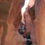
We then bushwacked our way west. And bushwack is the word for it! We’re talking stiff, pokey bushes higher than my head, growing close enough together that I had to elbow my way through. It was almost impossible, and I was very thankful for long sleeves and leggings! There are animal trails, but they usually peter out pretty quickly.
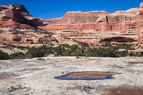
After an eternity that was only about 0.2 miles, we crossed over a small wash and found our way up a slickrock slope by heading north (it looked like a watercourse came down the rocks here). You’ll be happy to know that the worst is over, though there are still a couple of tricky moves to come.
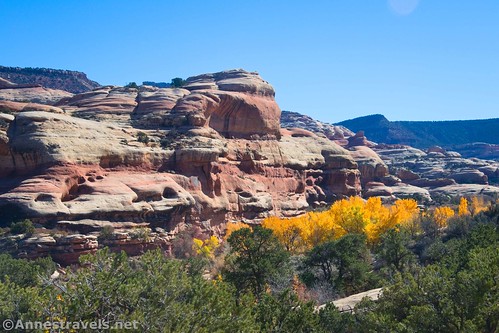
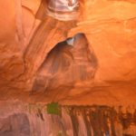
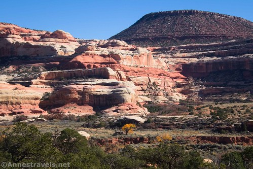
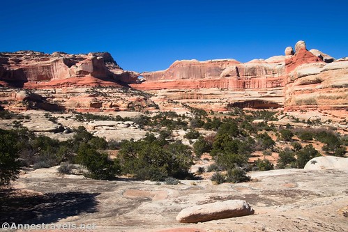
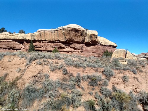
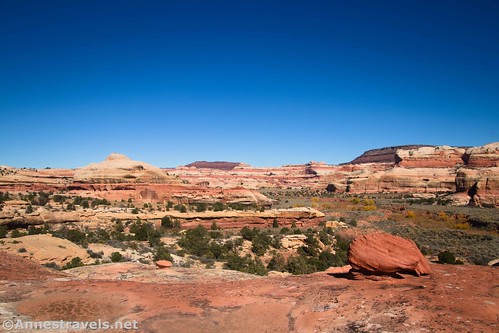
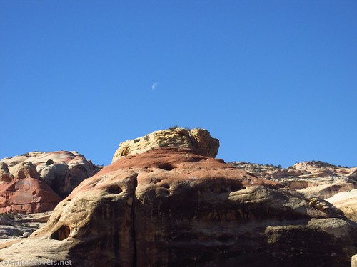
Once on top of the white slickrock, go over toward the far side and then work your way right (east) to the other side of the large monolith that sits on top of the white slickrock. On the far side, about 0.4 miles from the waterfall, you’ll find a really cool rock hoodoo/spire and fabulous views down on Salt Creek.
I only found this view on the way back (actually, some of my group found it while I was off looking for Kirk Arch and took me there on my way back). But it’s well worth seeing. It’s the best view I saw all day!

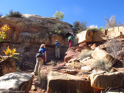
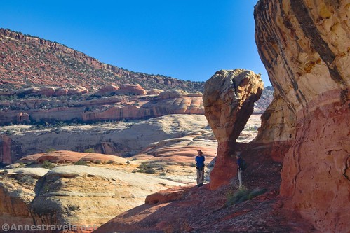
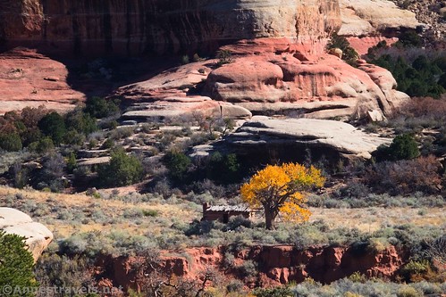
At this point, most of my group decided they’d had enough and would just wait for me to find or not find whatever I wanted at Kirk Arch. But I pressed on northward, locating a descent off of the white slickrock and down into a side wash of Salt Creek (getting down was not especially easy; the wash has a deep trench in the bottom and there is some foliage). I scrambled up the other side and then found a sketchy ascent up the white slickrock on the other side of the side wash. As I climbed, I spotted an ancient ruin.

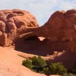
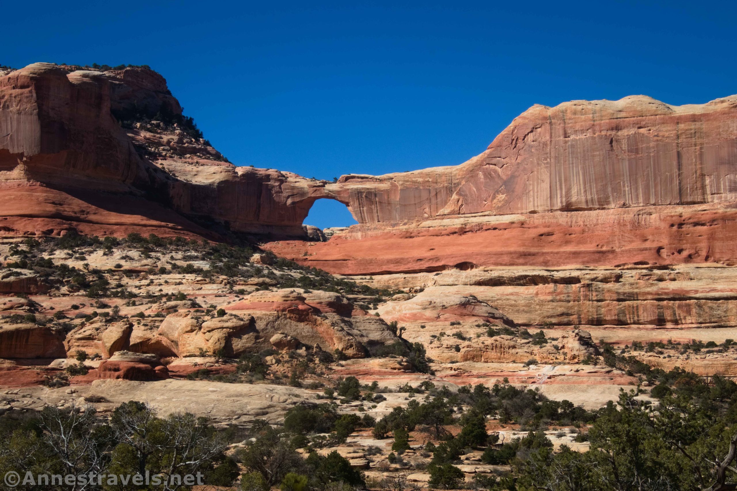
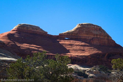
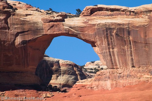
Finally once again on top of slickrock, and with the worst over with, I headed northwest and west toward where I knew Kirk Arch would be. It was there, too. A visitor specialist in Moab had dashed any hopes of getting to the arch, itself, but he said that we could get close on the slickrock. The walking was pretty easy and mostly on slickrock. Occasionally, I had to cross sections of soil, but there always seemed to be animal trails I could follow.
About this point, I found one of my intrepid group members had followed me via his own route. The two of us continued to a plain above a side canyon with a great view to Kirk Arch about a mile after leaving the Salt Creek Trail at the waterfall.
I’m sure we could have gotten closer if we’d wanted to. It would likely have required either skirting some side canyons of side washes off of Salt Creek or else some scrambling up and down into and out of said canyons. But we decided the day was too far spent to go much further. (We’d gotten a late start because we had to drive in from Moab before starting our hike. And it gets dark early in November.)

So we took our photos, admired the arch, and retraced our steps back to the spire. (We did find a better way down into the side wash via some boulders and an advantageously-placed dead tree.) From there, we found our way back down to the bushwack section and then back to the Salt Creek Trail.

Overall, it was definitely an adventure! (One I’d probably do again if I happened to be in the area with some extra time.) The bushwacking was the hardest part, per me, but you also need to be very skilled in desert scrambling and finding a route without a trail. I also highly recommend a good sense of direction. It would be easy to get turned around in the bushwack area. Add to this the physical requirements – you’re a minimum of 4 miles from the trailhead before you even leave the trail at the waterfall to search for Kirk Arch, and the scrambles aren’t for those with vertigo. A better approach would probably be to snag a permit to camp at SC1 or SC2 campsites so you don’t have to do the entire trip (out and back) in a single day. Backcountry permits can be reserved here (currently $5/person/night + $36/reservation).
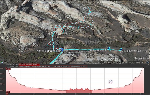
Round Trip Trail Length: 10.2 miles out & back (not including if you hike the extra 0.5 miles RT if you also visit Kirk Cabin)
Elevation Gain: 479ft. (5,972ft. to 6,028ft.) just for the Kirk Arch route; including the rest of the trail, you’re talking more like 1,465ft. (7,067ft. to 5,927ft.)
Facilities: None
Fees: $30/vehicle, valid 7 days. America the Beautiful National Park & Federal Recreational Lands Passes and Southeast Utah Parks passes are also accepted.

Trail Notes: Use care not to lose your way, since the entirety of this route is off-trail (after leaving the Salt Creek Trail near the waterfall). Long pants and long sleeves are recommended, especially for the bushwack section. Use care, as some of the scrambles are a little sketchy (I felt getting up and down the canyon between the two white slickrock sections was Class 3 bordering on Class 4 scrambles). Do not enter or in any way disturb ancient ruins which can be found in the canyons surrounding Kirk Arch. If you find old squash vines, these are left over from stashes once stored by ancient Puebloans. This route would be extremely hot on a warm day; I highly recommend that you not try this June-September.

Trail 
![]()
![]()
![]()
![]()
Road ![]()
Signs ![]()
![]()
![]()
Scenery
Would I go 100 miles out of my way for this? ![]()
Overall Rating: ![]()
![]()

GPS Coordinates for Kirk Arch
Upper Salt Creek TH: 37.950059, -109.706573 (37°57.00354′, -109°42.39438′ / 37°57’00.2124″, -109°42’23.6628″) (7,052ft.) (0.0)
Begin down wash/rocks: 37.957451, -109.710484 (37°57.44706′, -109°42.62904′ /
Waterfall: 37.983102, -109.745401 (37°58.98612′, -109°44.72406′ / 37°58’59.1672″, -109°44’43.4436″) (5,931ft.) (4.12)
Kirk Cabin: 37.985592, -109.743761 (37°59.13552′, -109°44.62566′ / 37°59’08.1312″, -109°44’37.5396″) (5,909ft.) (4.38)
Cross stream (leave trail): 37.983019, -109.745419 (37°58.98114′, -109°44.72514′ / 37°58’58.8684″, -109°44’43.5084″) (4,932ft.) (4.79)
Kirk Arch Overlook: 37.988198, -109.751648 (37°59.29188′, -109°45.09888′ / 37°59’17.5128″, -109°45’05.9328″) (5,997ft.) (~5.7)
Spire (hoodoo): 37.983809, -109.747391 (37°59.02854′, -109°44.84346′ / 37°59’01.7124″, -109°44’50.6076″) (6,014ft.) (~6.1)
Return to Trail: 37.982979, -109.745191 (37°58.97874′, -109°44.71146′ / 37°58’58.7244″, -109°44’42.6876″) (5,948ft.) (7.02)
End: 37.950070, -109.706595 (37°57.00420′, -109°42.39570′ / 37°57’00.2520″, -109°42’23.7420″) (7,051ft.) (11.13)

The gpx file for Upper Salt Creek to Kirk Cabin and Kirk Arch can be downloaded – please note that this and the GPS Coordinates are for reference only and should not be used as a sole resource when hiking this trail.
Download GPX File size: 231.7 KB Downloaded 511 times
(Note: I do my best to ensure that all downloads, the webpage, etc. are virus-free and accurate; however, I cannot be held responsible for any damage that might result, including but not limited to loss of data, damages to hardware, harm to users, from use of files, information, etc. from this website. Thanks!)

Getting to the Upper Salt Creek Trailhead
From US-191 39 miles south of Moab, Utah (or 14.4 miles north of Monticello), turn onto UT-211 (signed for Canyonlands National Park and Newspaper Rock). Drive 20.2 miles to a somewhat unassuming dirt road on the left. No sign marks the junction, but there are three ways to find it: 1) it has a cattle guard (not that helpful; many of the sideroads have cattle guards), 2) it’s right after passing a sign with some of the park rules (I think that’s what it’s about; I’m usually driving in after dark), and 3) there is a primitive restroom almost as soon as you leave the pavement (a signboard is near the restrooms). There may also be signs about Beef Basin or Elk Mountain; however, I believe these signs have not been up in a while.
Stay on the main dirt road (gravel at this point) as it crosses a wash (sometimes with water in it – I broke ice on my last visit and was grateful for high clearance!). If you can pass this obstacle, you’re probably good to go to get to the Upper Salt Creek Trailhead.
Follow the road as it winds past buttes, canyon walls, sideroads, campsites, and generally beautiful scenery. In general, the road is typically in reasonable repair (I did it in a Toyota Camry) but does have washboard. Use caution when the road crosses small washes on corners; these can be harmful to a low-clearance undercarriage).

At long last, 16.7 miles from the pavement, pass by a sideroad on your right. This is the Big Pockets Overlook Road and is 4×4 only, but it’s a good indication that you’re almost there. A mile later, you’ll come to the driveway into the parking area for Upper Salt Creek. Yay! You made it!
Now you just have to hike down the Upper Salt Creek Trail about 4 miles to the top of the waterfall to begin your off-trail trek to Kirk Arch!
This Week’s Featured Product
If you’re looking for hikes off the beaten trail (and on it!) in Canyonlands, this one is a great resource. Buy your copy here!