
There are so many free and fun trails around Moab, Utah. Trails that are often overlooked because they’re not in the national parks. Some of these (like Corona Arch) are becoming fairly popular in their own right, but others take a little more digging to find. Such is Longbow Arch, located in the slickrock above the Colorado River. Along the way, you’ll be treated to some very nice rock art and real, honest-to-goodness dinosaur tracks! (And that coming from someone who is very difficult to impress when it comes to both rock art and supposed dino tracks!)
Quick Stats
Note: Some of the links in this post are affiliate links. If you click one and purchase something, I may earn a small commission without an extra cost to you.
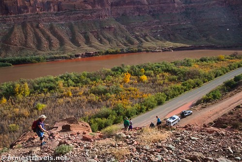
The trailhead is at the beginning of the Poison Spider Road on UT-279 (the road to Potash). A parking area allows for quite a few vehicles. I have a feeling it was created for people to park their pickups and trailers while they go off-roading, but it works quite well for the trail, as well, and even has a primitive restroom.

The trail is a little tricky at first. We pretty much stayed left at every junction. A group of tourists had just arrived to see the dinosaur tracks and the rock art, which is at the very beginning of the trail. So we figured we’d catch those on the way back.

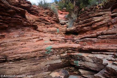
Maps at the trail junctions help describe the three or so trails that wind through the small section at the beginning. Turn left at the junction for the dinosaur tracks, then left again at the junction for the petroglyphs. After this, the trail steeply climbs a watercourse, marked with rectangles of green paint, and you know you’re on the right trail to Longbow Arch!
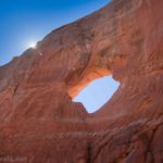
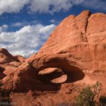
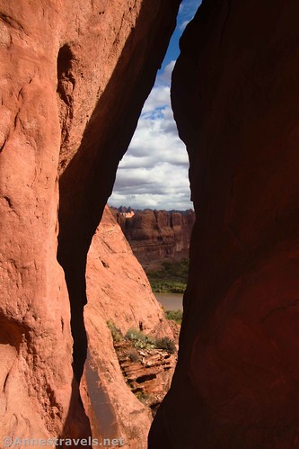
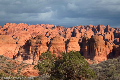
At the top of the watercourse, enjoy peek-a-boo views through an arch – the spires across the Colorado River are Behind the Rocks. Turn left to follow the trail and the green blazes.
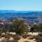
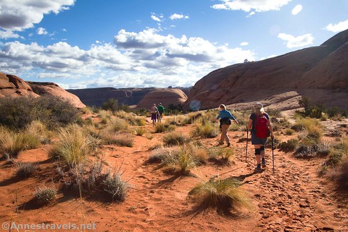
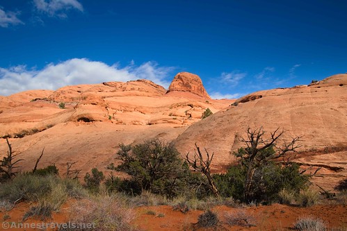
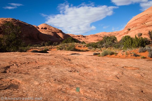
The trail winds up across sand and slickrock with views to various rock formations. In busy times of the year, chances are that you’ll hear vehicles on the Poison Spider Road to the south. The road passes right below the bluff the trail is traversing.
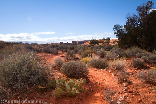
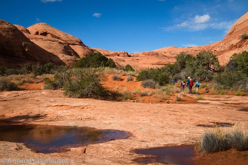
After about half a mile, the trail turns due north to work its way up a broad canyon. I loved the views of rock formations and a small stream in this section (it had rained all morning, so the washes were pretty damp!)

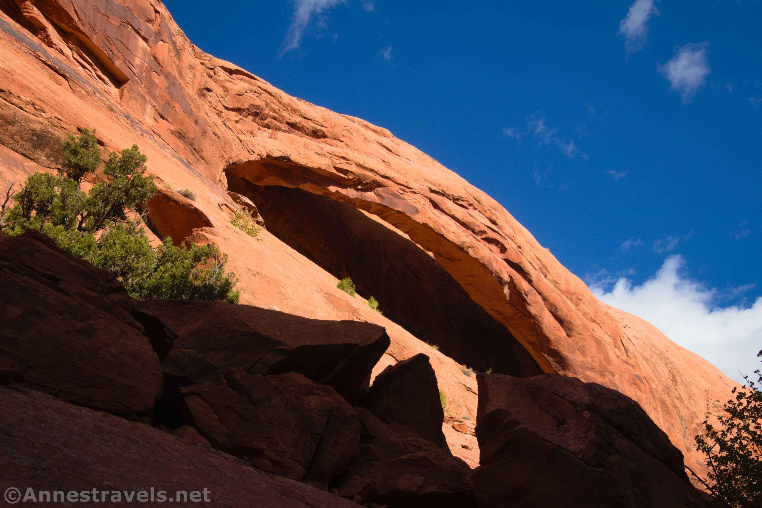
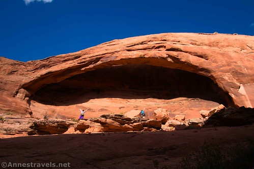
A mile from the parking area, the trail turns sharply east up a side canyon. Shortly after this, you’ll get your first view of Longbow Arch, high on the wall to the left.

The trail becomes sketchier as you approach the arch. You’re scrambling up a watercourse that narrows as it ascends; this includes a few Class 2-Class 3 climbs. I lost the trail multiple times in this short section, but it’s not a big deal because it’s hard to get lost! Eventually, when the slickrock slope on the left becomes level enough to climb, you’ll want to scramble up the slickrock and stand under the arch!
We met a couple of families coming down from the arch, and then on the way back, we met a couple more. But it had been raining all morning and the sun had just come out as we were hiking. So it makes sense that there were only a few brave souls on the trail!

Standing under the arch is awesome, and I can’t accurately portray it in photos. I’ve read that Longbow Arch is over 100ft. long, though other sources suggest it’s only 60ft. by 30ft. Either way, just try leaning against the slickrock wall underneath it and look up at the clouds floating by. Wow!!!

Return by the way you came. Except…
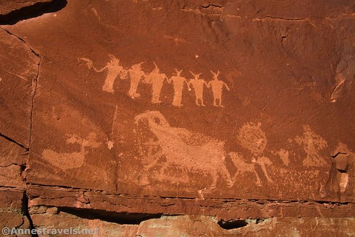
At the trail for the petroglyphs (just below the steep watercourse), turn left along the narrow shelf of a trail. It will lead you directly to the rock art on the cliff.

I was highly impressed with this rock art. It is clear, varied, and covers much of the cliff wall without being crowded.
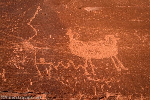
Some of the rock art has been defaced (before recent times, I believe), but much of it is still very much enjoyable to look at.

At this point, you have a choice to make. You can retrace your steps to the petroglyphs junction and head down to the dinosaur tracks junction, or…
…or you can do what we did, which is to take the very sketchy trail that switchbacks down along the edge of the cliff. It looks terrifying from above, and it does have its slippery moments. But we all made it down in one piece. And it delivered us straight to the dinosaur track exhibit. Yay!
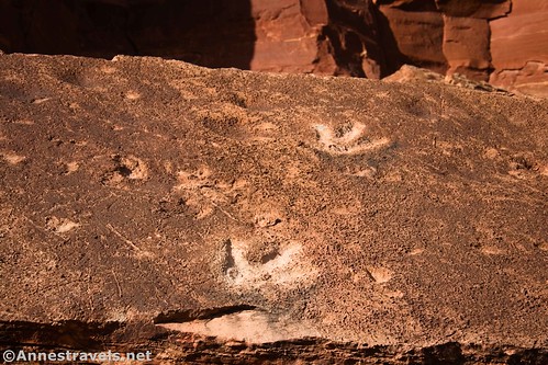
The dinosaur tracks are some of the best I’ve seen in Utah. They’re clearly defined in the rock and very visible (they’re not even behind plexiglass!)

Apparently, it’s a thing to pour water into dinosaur tracks (who knew?) Just don’t! There are signs everywhere asking you not to pour water in the tracks. (I feel like I should insert a shrugging emoji here.)
From here, it’s 0.2 miles back to the parking area. The entire thing is under 3 miles, so it’s a great, short hike without a lot of crowds but a whole lot to see!
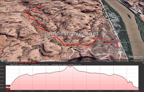
Round Trip Trail Length: I went 2.7 miles; out & back to the arch would be about 2.6 miles, so seeing the rock art and dinosaur tracks alone would be about 0.25 miles RT
Elevation Gain: 717ft. (3,990ft. to 4,429ft.)
Facilities: Primitive restrooms at the trailhead
Fees: None

Trail Notes: Dogs are allowed on this trail; if it’s hot, be sure your pup is wearing booties. The worst of the elevation gain is right at the beginning and the scramble up to Longbow Arch. The arch faces south, so it’s better in the fall, winter, and spring months rather than in the summer when the sun is further north.

Trail 
![]()
![]()
Road ![]()
Signs ![]()
Scenery
Would I go 100 miles out of my way for this? ![]()
Overall Rating: ![]()

GPS Coordinates for Longbow Arch
TH: 38.532834, -109.608602 (38°31.97004′, -109°36.51612′ / 38°31’58.2024″, -109°36’30.9672″) (3,998ft.) (0.0)
Dinosaur Tracks Junction: 38.533435, -109.608304 (38°32.00610′, -109°36.49824′ / 38°32’00.3660″, -109°36’29.8944″) (4,011ft.) (394ft.)

First view of Longbow Arch: 38.542375, -109.614926 (38°32.54250′, -109°36.89556′ / 38°32’32.5500″, -109°36’53.7336″) (4,336ft.) (1.11)
Longbow Arch: 38.542267, -109.612947 (38°32.53602′, -109°36.77682′ / 38°32’32.1612″, -109°36’46.6092″) (4,434ft.) (1.29)
Shortcut to dinosaur tracks: 38.533816, -109.608864 (38°32.02896′, -109°36.53184′ / 38°32’01.7376″, -109°36’31.9104″) (4,095ft.) (2.48)
Dinosaur Tracks: 38.533777, -109.608368 (38°32.02662′, -109°36.50208′ / 38°32’01.5972″, -109°36’30.1248″) (4,092ft.) (2.53)
End: 38.532927, -109.608729 (38°31.97562′, -109°36.52374′ / 38°31’58.5372″, -109°36’31.4244″) (4,007ft.) (2.70)

The gpx file for Longbow Arch (and the petroglyphs and dino prints) can be downloaded – please note that this and the GPS Coordinates are for reference only and should not be used as a sole resource when hiking this trail.
Download GPX File size: 62.9 KB Downloaded 373 times
(Note: I do my best to ensure that all downloads, the webpage, etc. are virus-free and accurate; however, I cannot be held responsible for any damage that might result, including but not limited to loss of data, damages to hardware, harm to users, from use of files, information, etc. from this website. Thanks!)
Getting to Longbow Arch
From Moab, drive north on US-191 (toward Arches and the Colorado River). Just after crossing the Colorado River (and before you get to the entrance to Arches National Park), turn left onto UT-279. Drive 5.9 miles to a dirt driveway on the right, signed on the left for Dinosaur Track and Poison Spider Trail. Turn right and then take another right into the parking area. Despite being dirt and quite steep, it’s usually passable by low-clearance vehicles.
This Week’s Featured Product!
Check out the best easy hikes in Moab in this FalconGuide! The trails include paths in Arches and Canyonlands National Parks as well as the surrounding area. Buy your copy here!