

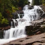
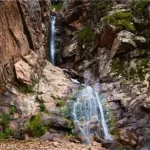
In my rambles around the internet (and social media), I’d seen a cool waterfall where the water fell through a hole in the rock. It was named Donut Falls and was near Salt Lake City. So when I found myself in SLC for a few days, I decided to go find this famous waterfall. While I was at it, I decided I’d hike up nearby Kessler Peak, since it leaves from the same trailhead in Big Cottonwood Canyon. Donut Falls ended up being a slight disappointment (you’re not allowed to see the donut part of the falls), but the views from Kessler Peak were stunning (even if the trail up was breathtaking!)
Quick Stats
We started out about noon. On a weekday in September, we were able to get the second-to-last parking space in the upper lot (so grateful for someone who helped us navigate the van into the parking space… the space wasn’t tight, but the parking area is so narrow that trying to turn a full-size van into a spot behind a full-size pickup truck was quite the feat). We ate lunch and then followed the signs for the detour to Donut Falls (which mostly just meant following a dirt road instead of a trail).
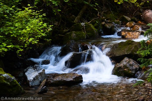
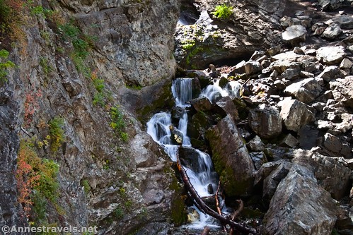
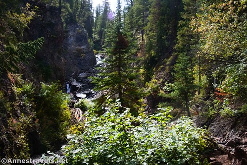
The dirt road took us up along the creek (Mill D South Fork, but that’s too long for such a little stream). It rushes and gurgles and tumbles down small cascades for much of its route. Be careful after about mile 0.4 to take the left fork of the road – the right fork either is or leads to private property. If you took the Donut Falls Trail (which was closed when I visited), the trail would meet up with the road just after this junction.
About 0.7 miles from the trailhead, the path suddenly drops into the streambed. Between plenty of hikers and plenty of floods, it appears that you’ve reached the end of the navigable trail. However, by scrambling up the streambed on the right side, you can continue another tenth of a mile to Donut Falls.
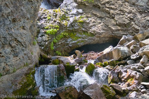
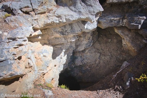
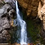
At the bottom of the falls, signs forbid you from climbing any higher. It’s a pity in that you can’t really see the donut part of the falls. There are rocks ‘way up near the top of the cascade that – if you look carefully – seem to have the falls flowing onto the top and then out underneath. But from this distance, it’s hard to say whether the water is going through boulders or somehow finding its way through a single rock (or, as the case might be, flowing through one hole in a rock and out another hole in a rock).
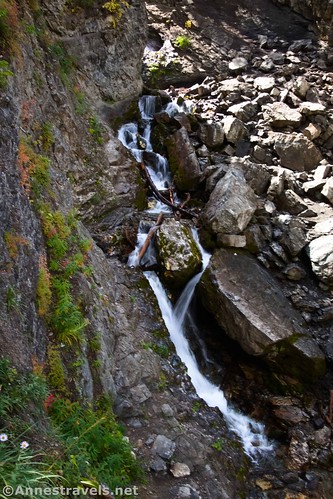
I did scramble up to the left side (not beyond the sign, surely!) following some social trails. It gave me a much better view. There was also enough of a different angle to use my zoom lens to at least get a few photos of the donut, even if I couldn’t hike up there.
With that more or less busted, we set toward finding the Kessler Peak Trail. The problem was that my directions 1) took you down the Donut Falls Trail instead of the road, and 2) took you up a maybe-private road that currently had a sign saying that no one was allowed up it, or else. I knew that the Kessler Peak Trail itself was on public land, and since (thankfully!) I had a GPS coordinate for where the trail struck off of the supposedly-closed road, we walked back down the Donut Falls Trail and then took a social path (not a very good one) up the hillside. It popped us out on the supposedly-private road just below where the Kessler Peak Trail turns right off up the hillside.
The junction was clearly if quietly marked with a small pile of stones. The Kessler Peak Trail itself is used often enough that it’s also fairly obvious if you’re looking for it.
From the first, the Kessler Peak Trail shoots upward at an alarming rate. (And when I say alarming, I mean truly terrifying – it just about goes straight up!) I was pushing 150 miles of hiking over a little less than two weeks, but this trail took the cake for both steepness and strenuousness.

A short distance up the trail, we came to two badly vandalized private property signs. Someone had even written some rather uncomplimentary messages on one of the signs ending with something like – “This is public property, so just ignore the signs.” Apparently, someone really loves this trail and keeps it open; even the big trees that fall across the path are cut. From what I can tell on maps, the trail is entirely within the national forest, so I’m not sure why there would be private property signs.
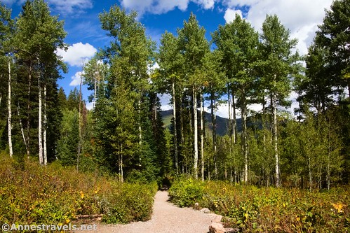
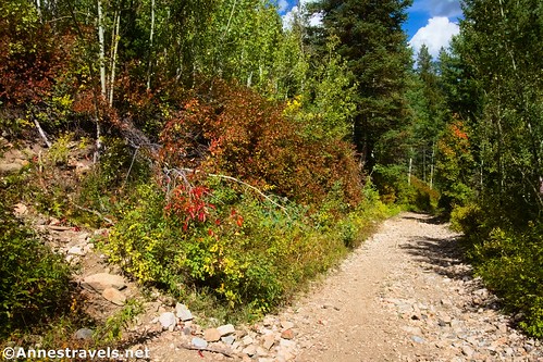
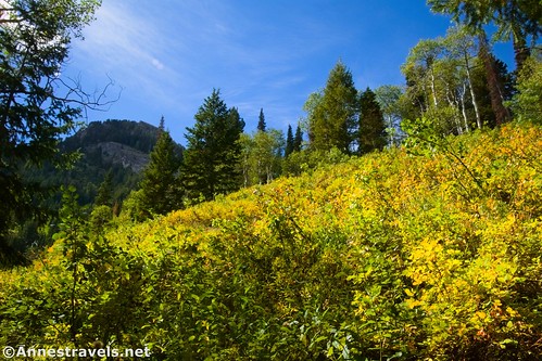
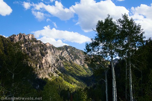
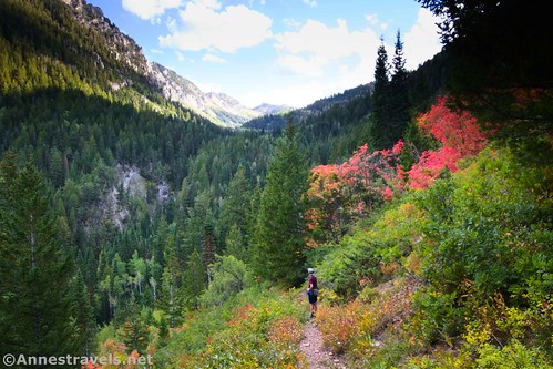
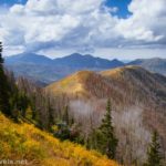
The trail climbs through aspen forests and occasional small meadows with peek-a-boo views to mountains on the other side of the valley. Actually, these views started almost as soon as you left the Donut Falls Trail, but they will get better at the top of the mountain.
The foliage changes from aspens to fir trees as the path climbs higher, beginning to steeply switchback up the north-facing slope of the mountain. Don’t give up! This is probably the most dismal portion of the trail… it feels like you’ve been hiking uphill forever, but you’re still not quite there yet!
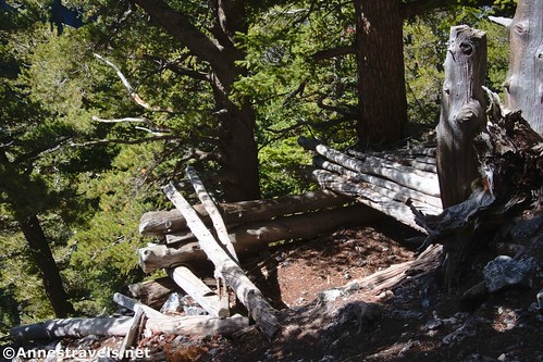
About 1.8 miles after leaving the supposedly-private road, you’ll come to the remains of a cabin. Nearby is a peek-a-boo view to the northwest. A quarter mile up the trail is a mine audit. Keep climbing; you’re almost there!
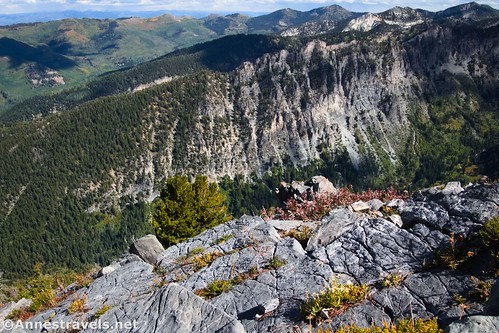
A tenth of a mile or so beyond the mine, it looks like the trail splits, with the left path rising to the rocky ridgeline and the right branching across the side of the mountain as though to bypass the peak. If you’re just looking for a quick view, turn left and you’ll get a pretty good one. But to reach the peak, turn right.
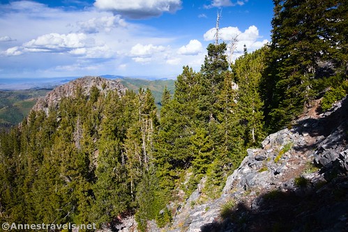
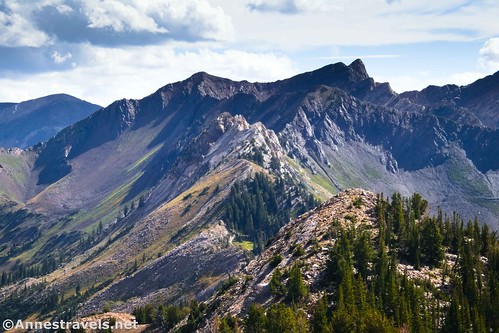
The path is sketchy at times (I wasn’t super happy about the exposure in one place!) as it scrambles along the mountainside and up and over rocks. But it will get you to the top of Kessler Peak more easily than hiking along the ridgeline (yes, I went left and then tried to reach the peak via the ridgeline… not fun with a lot of rock scrambling).
At last, 3.5 miles from the trailhead (if you went to Donut Falls, too; if you didn’t, it’s closer to 2.6 miles… I’m not sure how that math worked out; it felt at least twice that) you’ll finally crest the top of Kessler Peak!
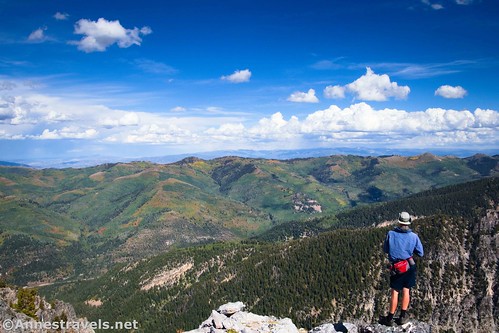
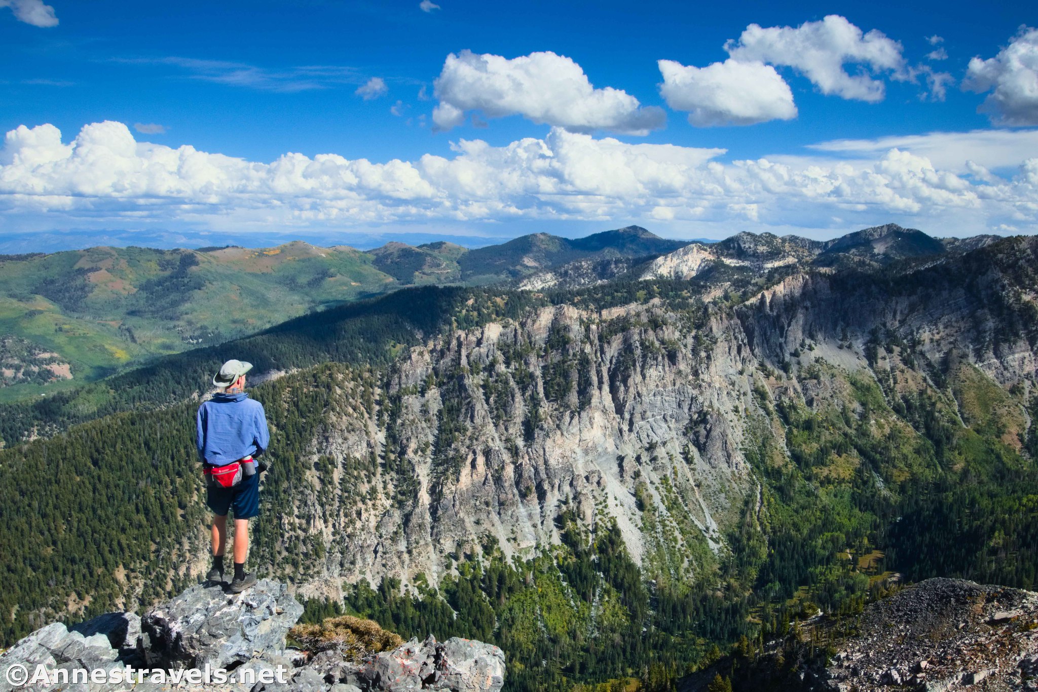
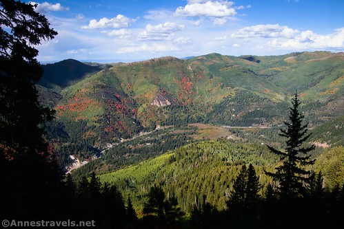
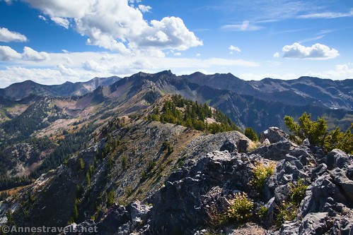
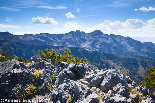
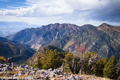
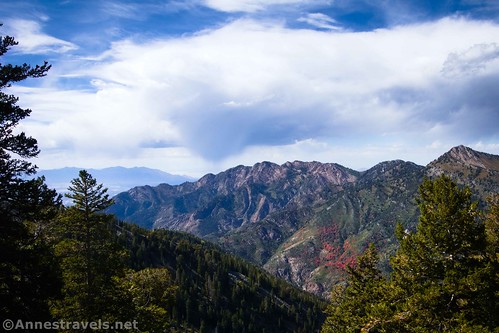
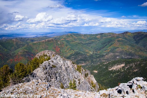
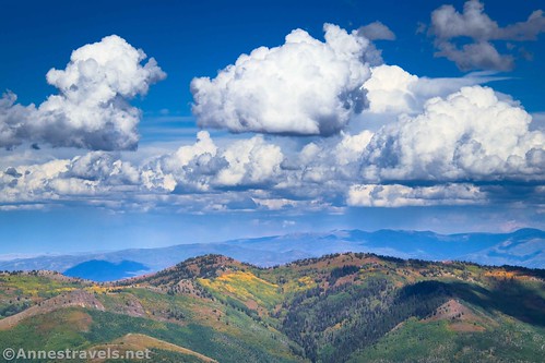
The views from the top of Kessler Peak are stunning in all directions. My favorite views were to the east into the valley which contains Donut Falls.
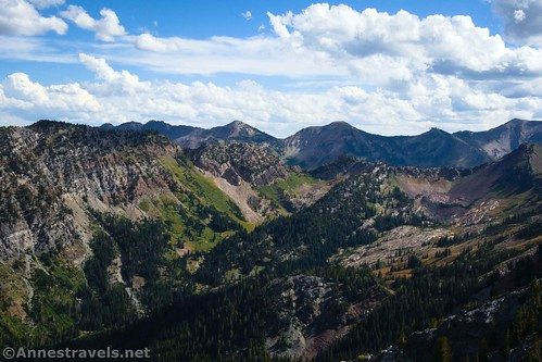
To the west are Sandy and Salt Lake City; to the north are Mt. Reymond, Gobblers Knob, and Little Water Peak. To the south is Mt. Superior and many other peaks (including a few around Lake Blanche).
The fall colors were just beginning, so we had the benefit of red and orange patches on the mountainsides. Wow!
Enjoy the great views before heading back down. We met two single guys on our way back; one hikes this trail frequently, and the other hadn’t been up here in about three years and was loving it. I’d say those Salt Lake City hikers are tough cookies!
Descending was easier on the lungs and harder on our legs! I’m simply not used to that kind of steepness. But it was also faster, so we ended up back on the Donut Falls Trail in 1.1 miles and then the parking area 0.5 miles later. The good news was that most of the cars had left, and getting out of the parking area was much easier than trying to park in the first place!
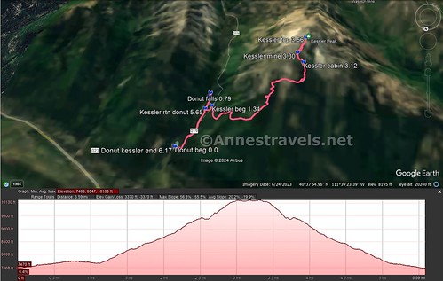
Round Trip Trail Length: I went 6.2 miles including Donut Falls. Donut Falls on its own is 1.6 miles, and Kessler Peak without Donut Falls is around 5.2 miles.
Elevation Gain: 3,370ft. (7,468ft. to 10,130ft.)
Facilities: Vault toilets at the trailhead
Fees: None $10/vehicle for a 3 day pass, $20 for 7 days, or $60 for an annual pass (Uinta-Wasatch-Cache National Forest Pass). America the Beautiful National Parks & Federal Lands Passes are accepted.
Trail Notes: Donut Falls is extremely popular; the chances of getting a parking spot at the trailhead after 8am are slim. The Forest Service recommends parking at the base of the entrance road and hiking the trail up to the trailhead (it is a trail, not hiking on the road). Due to multiple injuries, etc., signs prohibit hiking close to or up Donut Falls. I’ve already waxed eloquent on the steepness of the trail up to Kessler Peak, so take your hiking poles, take your time, and take plenty of water and snacks (I felt the trail was twice as long as reality). Kessler Peak was named for Frederick Kesler (1816-1899; note the single s), a Mormon bishop, mill architect, school warden, and justice of the peace.
Trail 
![]()
![]()
Road ![]()
![]()
Signs ![]()
![]()
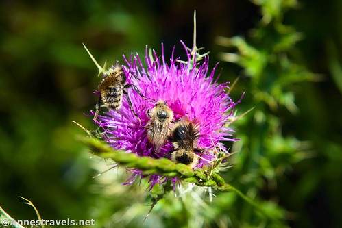
Scenery
Would I go 100 miles out of my way for this?
Overall Rating: ![]()
GPS Coordinates for Donut Falls & Kessler Peak
TH: 40.6396280°, -111.6512550° (40°38.37768′, -111°39.07530′ / 40°38’22.6608″, -111°39’04.5180″) (7,473ft.) (0.0)
Stream: 40.6321250°, -111.6544650° (40°37.92750′, -111°39.26790′ / 40°37’55.6500″, -111°39’16.0740″) (7,751ft.) (0.72)
Donut Falls: 40.6314910°, -111.6545170° (40°37.88946′, -111°39.27102′ / 40°37’53.3676″, -111°39’16.2612″) (7,776ft.) (0.79)
Kessler Beginning: 40.6336440°, -111.6552930° (40°38.01864′, -111°39.31758′ / 40°38’01.1184″, -111°39’19.0548″) (7,728ft.) (1.34)
Cabin: 40.6286140°, -111.6686600° (40°37.71684′, -111°40.11960′ / 40°37’43.0104″, -111°40’07.1760″) (9,832ft.) (3.12)
Mine: 40.6274470°, -111.6676330° (40°37.64682′, -111°40.05798′ / 40°37’38.8092″, -111°40’03.4788″) (10,143ft.) (3.30)
Kessler Peak: 40.6251490°, -111.6687290° (40°37.50894′, -111°40.12374′ / 40°37’30.5364″, -111°40’07.4244″) (10,359ft.) (3.56)
Return to Donut Falls Trail: 40.6340370°, -111.6543090° (40°38.04222′, -111°39.25854′ / 40°38’02.5332″, -111°39’15.5124″) (7,650ft.) (5.65)
End: 40.6397140°, -111.6512780° (40°38.38284′, -111°39.07668′ / 40°38’22.9704″, -111°39’04.6008″) (7,470ft.) (6.17)
The gpx file for Donut Falls & Kessler Peak can be downloaded – please note that this and the GPS Coordinates are for reference only and should not be used as a sole resource when hiking this trail.
Download GPX File size: 139.4 KB Downloaded 395 times
(Note: I do my best to ensure that all downloads, the webpage, etc. are virus-free and accurate; however, I cannot be held responsible for any damage that might result, including but not limited to loss of data, damages to hardware, harm to users, from use of files, information, etc. from this website. Thanks!)
Getting to the Donut Falls & Kessler Peak Trailhead
From I-215, take Exit 6 for 6200S and UT-190E. If coming from SLC on I-215S, stay left to turn left onto Big Cottonwood Road; if coming from Provo and I-215N, stay right to turn right on Big Cottonwood Road. After 0.7 miles, continue straight onto Wasatch Blvd E for another mile. Turn left onto UT-190E/Big Cottonwood Canyon Road. Drive 8.9 miles up into the mountains. At this point, you can park in the large lot and then take the trail (not the road) up to Donut Falls. However, I decided to try and get a parking space up at the Donut Falls Trailhead – and I did! To do so, turn right on S Cardiff Fork Road and steeply ascend 0.8 miles to the tiny parking area at the trailhead.
Today’s Featured Product!
Mountains, waterfalls, lakes, and much more can be found in these 60 trails within 60 miles of Salt Lake City. There’s just so much to discover! Buy your copy here.

One response to “Hiking to Donut Falls & Kessler Peak in Big Cottonwood Canyon”
[…] From there, we drove down to the Salt Lake City area. Our first hike was up to Donut Falls… […]