Santaquin Peak in the Wasatch Mountain Range isn’t the loftiest of peaks nor is it the most famous. Even the trail to the top takes on the name of another peak, which (granted) is 2 feet taller. But it does have advantages, including 1) a trail all of the way to the summit and 2) a fantastic view most of the way along the trail!
Quick Stats
(This post contains affiliate links – there is no extra cost to you, but I may receive a small commission if you click and link and buy something.)

It was sunny when I started out on the Loafer Mountain Trail (marked Loafer Mtn TR. 098 (6 Miles)). It was also a fairly quiet morning. I’ve heard that the Mount Nebo Highway can be absolutely overrun, and it seemed to be set up for a good deal of traffic. However, on a Thursday in the middle of September, I’d seen less than a handful of cars (starting at about 7am may have had something to do with this, too). We parked in the small parking area, donned our gear, started up my GPS, and took off down the trail.

The path descends through the trees – it’s a bit of a disappointment, since you know you’ll be climbing a lot of elevation later! After only a tenth of a mile, don’t turn right on the Blackhawk Trail (TR. 084). Instead, continue on the Loafer Mountain Trail. These signs look new, so I expect they’ll be around for quite some time.

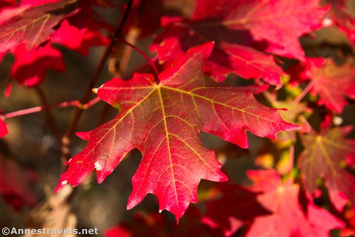
The path passes through aspen woods with occasional meadows and/or views to the surrounding area. The fall colors were just starting (they were apparently extremely late in 2023). There are a few very wet spots in this area, and since the trail is also open to motorcycles, mountain bikes, and horses, let’s just say that the muddy parts were pretty torn up. We used logs put down by helpful hikers and skirted the worst of the mud.
After not quite a mile, we came to the junction with the Bennie Creek Trail (TR. 071). This one threw me for a loop; I had no idea where we were supposed to go or do… and sadly, the map on my GPS wasn’t terribly helpful. We took a chance and continued straight (return into the trees and don’t cross the fence) – which thankfully was correct! The path descends to cross a small creek (dry in September).
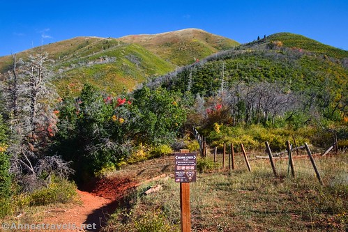
Only a tenth of a mile beyond the Bennie Creek Trail Junction, you’ll come to the turnoff for the Loafer Mountain Trail (horses and bicycles are still allowed, but motorcycles are not). Turn right here and begin the ascent.

The views improve as you climb higher. At this point, you’re in a deciduous forest, so the oaks were red and the aspens were just turning yellow. Spectacular!

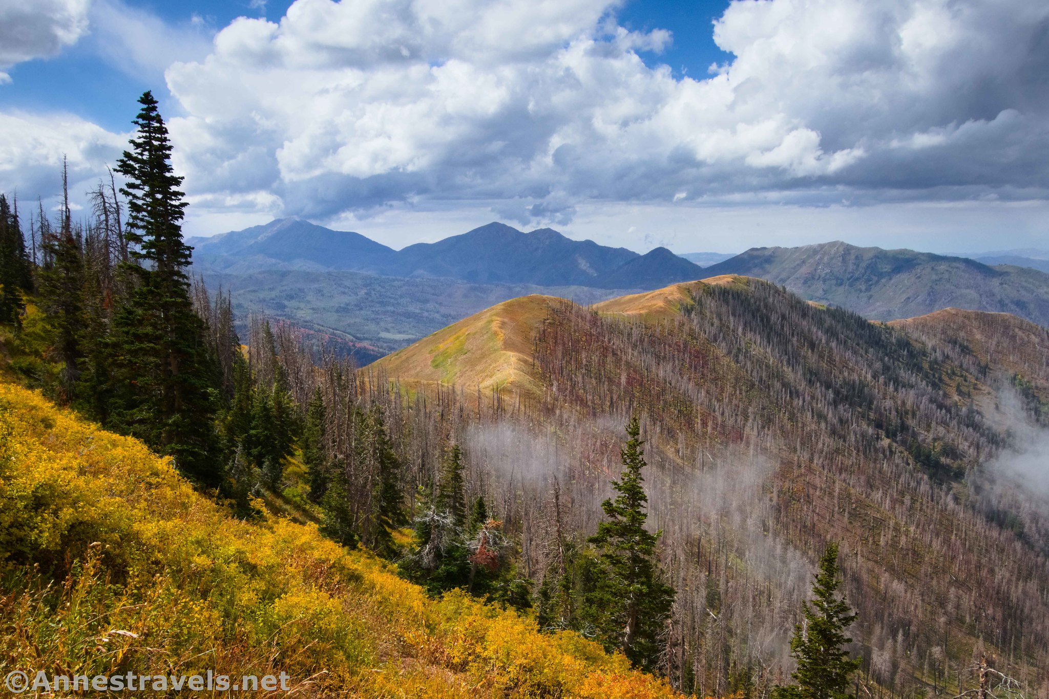
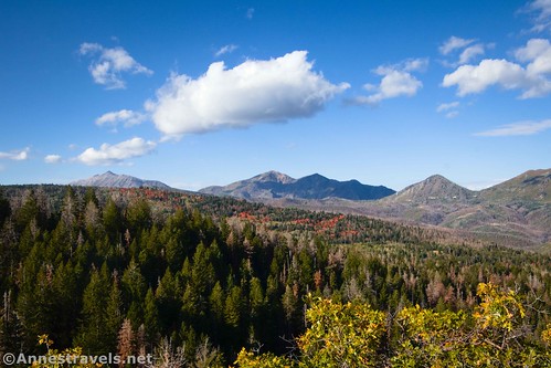
Views also open up across the valley to so many other peaks, most notably Mount Nebo, Bald Mountain, and Dry Mountain.

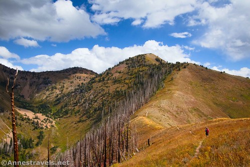
The trail is fairly steep as it switchbacks upward. There are a few reprieves, though these diminish as you reach the treeline and the trail becomes rockier. Use care, as the trail can be slippery with loose stones. At one point, I heard an elk bugling in one of the valleys below.
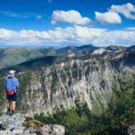
At last, 3.4 miles from the trailhead, we reached a type of saddle (very nearly the ridgeline). The views from here are fabulous, though they keep improving as you keep walking.

The path continues to climb another short distance up to the ridgeline. The grade abates for a bit.

About this point, I began to notice the clouds. There had been puffy clouds in the sky most of the morning, but these clouds were well below us, creeping up the valleys. I hoped this wasn’t a sign of what was to come.

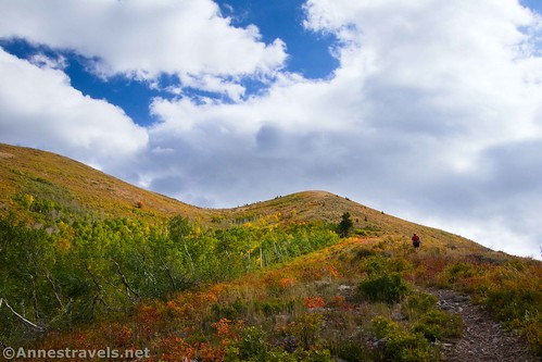
I totally loved this section of the trail. While it’s still climbing, it’s not as steep as before, and there are views in so many directions. Added to this, I’m in love with open yellow meadows and ridge walks.

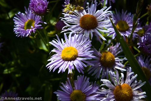
We also found a few wildflowers.
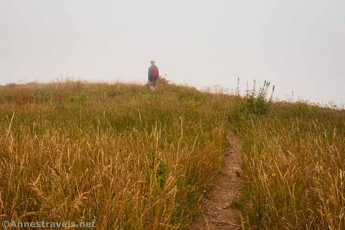
Up ahead, we could see Santaquin Peak… it seemed a long distance away still! The trail continues to wind along the ridgelines and through meadows (technically, you’re on Loafer Mountain at this point, as it extends from here to well beyond Santaquin Peak). And the clouds continued to creep up the valleys. It was fascinating in a wild sort of way. But we still had mostly sunshine. I also found a fallen-over sign that said “112.” It’s probably a trail number, but I’m not sure where the trail goes unless it was the one unmarked trail that heads off to the right along the ridgeline.
As the trail left the ridgeline to work up along the side of Loafer Mountain, the clouds continued to increase. It was coming – coming – and then the mist was all around us and we were in a world of meadows, a few trees, and filmy whiteness.

I was sad because I knew there would be even more great views, including down on Sandy Lake. But the mist had its own charm.

Along this section of trail, we met the only human being we saw all day – an older-side-of-middle-aged gentleman who always hikes Santaquin Mountain on the same day every year (or at least the same week – I think it coincides with his birthday). He couldn’t get over how the colors weren’t out yet; usually, they’re past their prime by the third week of September. Having never visited the Wasatch Range before, we didn’t know any better and were just enjoying what little color was showing!

The first veil of mist lifted enough to give us some limited views as we reached the final turn to the left that would take us up Santaquin Peak, below the col between Santaquin Peak (left) and Loafer Mountain (right). At this point, the trail becomes much rougher; I’d say some of the trail-on-scree sections border on sketchy Class 3 due to the exposure.

At last, the route (it’s not really a path anymore) turns right and it’s a quick scramble up to the peak. Yay! You’re only 6.1 miles from the trailhead!

Views would have been fabulous up here on a clear day. As it was, we were blessed with several breaks in the clouds that allowed us many more views than I would have thought given the mist and clouds.

Also, it didn’t thunder, and it didn’t rain long, which were both extremely good considering our position on top of a very exposed peak! There is also a summit register complete with a mailbox.

Since we were here, we enjoyed the shifting movements of the clouds while hiding behind a windblock and eating lunch. As we packed up our gear, we spotted mountain goats over on Loafer Mountain – a whole herd of mountain goats!

We descended back into intense mist, but it cleared by the time we arrived back at the ridgeline walk. The clearing-and-mist game continued as we hiked back down into the forest and then back to the parking lot.

Well before we got back to the van, we were pretty tired! Yes, we’d just hiked 100 miles in Yellowstone, but most of those trails were fairly flat and well under 12.1 miles. We’d also done Kessler Peak the day before, so our muscles were still pretty tired from that very steep trail. It felt good to rest our weary legs and head back down into Sandy!

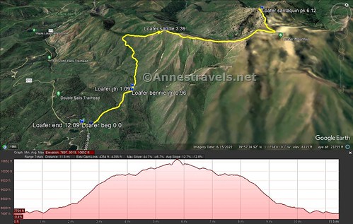
Round Trip Trail Length: 12.1 miles
Elevation Gain: 4,355ft. (7,697ft. to 10,652ft.)
Facilities: None
Fees: None

Trail Notes: This is a very steep, grueling hike. Bring plenty of water. It could also be very hot in the summer, as much of the route is exposed; you wouldn’t want to be out here in a thunderstorm. Yes, it’s true that the Loafer Mountain Trail takes you up Santaquin Mountain and never quite arrives at Loafer Mountain. You could scramble up Loafer (just to the southeast), but that would be quite a trek on its own. My favorite part of the trail was the sheer number of views in all directions, especially in the meadows.

Trail 
![]()
![]()
Road ![]()
Signs ![]()
Scenery
Would I go 100 miles out of my way for this?
Overall Rating: ![]()

GPS Coordinates for the Loafer Mountain Trail to Santaquin Peak
TH: 39.9407740°, -111.6440850° (39°56.44644′, -111°38.64510′ / 39°56’26.7864″, -111°38’38.7060″) (7,717ft.) (0.0)
Blackhawk Trail Junction: 39.9414790°, -111.6418490° (39°56.48874′, -111°38.51094′ / 39°56’29.3244″, -111°38’30.6564″) (7,706ft.) (0.14)
Bennie Trail Junction: 39.9519930°, -111.6409160° (39°57.11958′, -111°38.45496′ / 39°57’07.1748″, -111°38’27.2976″) (7,811ft.) (0.96)
Loafer Mountain Trail Junction: 39.9530210°, -111.6419430° (39°57.18126′, -111°38.51658′ / 39°57’10.8756″, -111°38’30.9948″) (7,709ft.) (1.09)

Saddle: 39.9679110°, -111.6446890° (39°58.07466′, -111°38.68134′ / 39°58’04.4796″, -111°38’40.8804″) (9,500ft.) (3.39)
Santaquin Peak: 39.9833190°, -111.6237380° (39°58.99914′, -111°37.42428′ / 39°58’59.9484″, -111°37’25.4568″) (10,612ft.) (6.12)
End at TH: 39.9408170°, -111.6440740° (39°56.44902′, -111°38.64444′ / 39°56’26.9412″, -111°38’38.6664″) (7,716ft.) (12.09)

The gpx file for Santaquin Peak via the Loafer Mountain Trail can be downloaded – please note that this and the GPS Coordinates are for reference only and should not be used as a sole resource when hiking this trail.
Download GPX File size: 210.3 KB Downloaded 373 times
(Note: I do my best to ensure that all downloads, the webpage, etc. are virus-free and accurate; however, I cannot be held responsible for any damage that might result, including but not limited to loss of data, damages to hardware, harm to users, from use of files, information, etc. from this website. Thanks!)

Getting to the Loafer Mountain Trailhead
From I-15S, take Exit 250 for Payson. At the end of the exit ramp, turn left to pass under the highway and enter the city of Payson. After 0.5 miles, turn left onto UT-198 E/E 100 N – follow signs for the Peteetneet Museum. Then turn right onto N 600 E 0.5 miles later (again, follow the museum signs). Continue straight on this road for a total of 12.0 miles as the road winds into the mountains. The small parking area will be on the left.
If coming from I-15N, take Exit 248 for UT-178 and 800 South. At the bottom of the exit ramp, turn right on W 800 S for 1.7 miles. Turn left on S 600 E Peteetneet Blvd an drive straight for a total of 11.4 miles up into the mountains. The small parking area will be on the left.
Today’s Featured Product
Explore the Wasatch Mountains with this classic – but updated – guide. It covers short strolls to true mountaineering routes. Buy your copy here!