

I’ve said it before, and I’ll say again here: there’s nothing quite like top-of-the-world views. There’s something so inspiring about being way high up, looking down over everything. So, when planning a recent trip to Beartooth Pass in Wyoming, I knew that I wanted to get out and experience this type of view from near the east end of the Beartooth Highway. I also knew that there aren’t a lot of hikes in the area, except those that go to lakes—these are mostly used by fishermen. I’m not as fond of alpine lakes as of being on top of a mountain, so these didn’t appeal to me. Therefore, I decided to leave the beaten paths and try some cross-tundra hiking—topo map in hand. In the end, I never got far enough from the highway to need the map, but it was beautiful. There were views in all directions, the hiking wasn’t too difficult because you’re on the tundra, and I really felt that top of the world feeling I was looking for!
(Affiliate links are present on this page.)
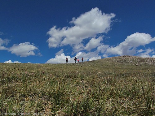
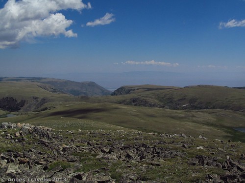
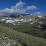
Start your hike by walking north/north east from the pull-out (described below). Your destination is the high spot ahead of you. If you came from the east (Red Lodge), you followed the road around this mountain to get to the parking area. On a topo map I looked at later, this peak is called “Wymont” and is 10,971 ft. above sea level. However, I didn’t know this at the time (so much for my maps!). You’ll never get far from the road on this hike, although you won’t be on the road, either, for most of it. Keep heading upwards across the short grass and small rocks towards the high point. At some times of the year, this would be very pretty with wildflowers; it was just dry grass when I visited in late July. As you approach the summit, there will be more rocks and less grass, until it’s nearly all volcanic-looking rocks on the summit. The great part about this part of the hike is that you’re really on top of the world here, and it feels like it. You’ve got blue sky and open tundra all around you; it’s pretty deserted up here besides the road, so you can feel like you’re alone, too!
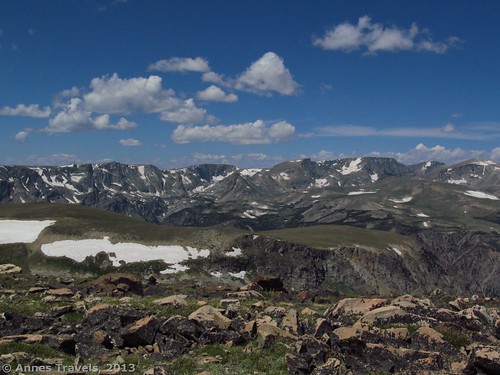
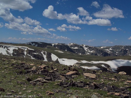
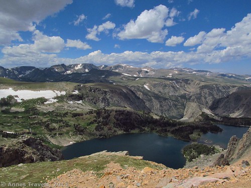
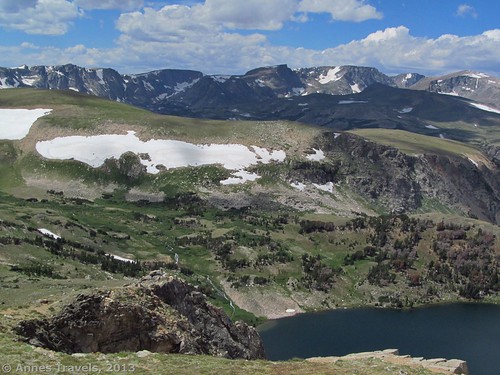
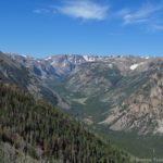
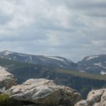
At last, you get to the top of Wymont Peak. Wow! What views! Over on your left (sort of across where the road would be) I could see snow-flecked peaks majestically rising up over sheer cliffs. A bit to the right are the snow-flecked hills of the Hellroaring Plateau (Mount Rearguard is very visible from here). You can also see the canyons where the tundra drops to the valley below you, Behind you is more tundra. On a semi-clear day, I could see all the way to the plains and on to another range of mountains, hazy on the horizon. You can see the highway from here, including the Wyoming/Montana boarder, but it wouldn’t be difficult to hunker down so the road was invisible. Drink in the view for a while: it’s not that far back to your vehicle from here. If you’re tired of looking at the view, you could also build cairns on top of the peak: you won’t be the first, nor the last I suspect!
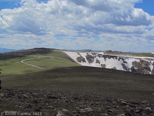
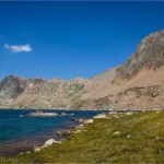
If you’re looking for some more adventure (or just some more pretty views), head straight down the hill toward the highway (which you can’t see at the moment—you’ll be walking west). This is somewhat steep, but not a difficult descent until you almost reach the highway. At that point there is a drop to the road. You will need to parallel the road until you find a place you can scramble down the embankment (it’s less than 5 feet high). Your destination is the pull-out on the other side of the road. From here, you will be able to see the Twin Lakes, which I talked about in another post. It’s another great view; similar to what you saw above, but not as high up, and with the lakes below you—these are beautiful on a sunny day.
Return to your vehicle by re-crossing the road and then paralleling it back to where you parked your vehicle. I wouldn’t walk along the road; there are many vehicles and the drivers are often looking at the views more than the road—the shoulders also aren’t very wide. So, I’d walk along the tundra near the road if I were you!
Though not an all-day excursion, this is a nice little side-hike from the Beartooth Highway…and a great way to let the driver enjoy the views outside your vehicle!
(By the way…I described a similar hike a little closer to the Montana line here.)
Getting to the Hike:
To get to the place I started my hike, from Red Lodge, MT drive up towards Beartooth Pass on US Hwy 212 (the Beartooth Highway) until you cross the state line into Wyoming. Along the way, you’ll pass Vista Point, which is well worth a stop. Exactly 2 miles after the state line, there will be a small, gravel pull-out on the left side of the road. The pullout is unmarked, but it’s the only one on the correct side of the road near here. If you’re coming from the west (Yellowstone National Park), this pull-out is on your right, 37.5 miles from Cooke City, MT, along US Hwy 212. Beartooth Pass is closed seasonally, so you’ll only be able to do this hike in the summer or early fall. Check the internet before going to make sure the road is open.
Key GPS Coordinates:
Pullout Parking Area: 44.980777 N / -109.426411 W (44 N 58’ 50.7972” / -109 W 25’ 35.0796”)
Top of the Mountain: 44.991038 N / -109.420727 W (44 N 59’ 27.7368” / -109 W 25’ 14.6166”)
Twin Lakes Lookout Area: 44.988712 N / -109.426827 W (44 N 59’ 19.3626” / -109 W 25’ 36.5772”)
Round Trip Trail Length: Less than 3 miles
Facilities: None
Fees: None
Trail 
![]()
![]()
![]()
Road ![]()
Signs ![]()
![]()
![]()
![]()
Scenery
Would I go 100 miles out of my way for this? ![]()
![]()
Overall Rating: ![]()
![]()
This Week’s Featured Product!
When you’re out in the Yellowstone wilderness, you really should have bear spray with you and in an accessible place. Although you can buy some at the hardware store in Red Lodge (we did, because we didn’t have time to buy it online before we left for Wyoming) it’s a lot more convenient to get it before you go. This little container is easy to hang in a convenient place so you can have it if a bear suddenly attacks and the pepper stays good for quite a while, too.

One response to “Top-of-the-World Views along the Beartooth Highway”
[…] A similar but slightly longer hike we did can be viewed here. […]