

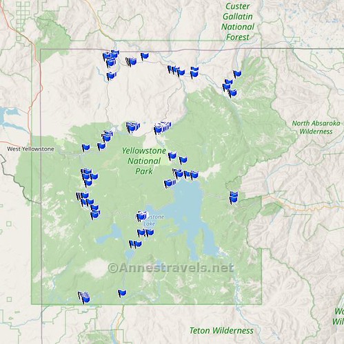
In case anyone has been wondering where I’ve been the last few weeks, the answer is that I’ve been working very hard to collect new content. That translates to many miles of hiking, lots of photography, plenty of GPS coordinates, and more than a little bit of driving and exploring! You all will reap the benefits of this over the next many months as I begin to share all the amazing scenery I saw in Yellowstone, Salt Lake City, Idaho’s Sawtooth Mountains, and Southern Utah. But for this post, I’d like to detail my time in Yellowstone National Park – and how, exactly, I hiked 105 miles in the park in just 11 days!
Note: Some of the links in this post are affiliate links. If you click one and purchase something, I may earn a small commission without an extra cost to you.

(All mileage is round trip. Remember that this is what I did; it’s not necessarily my recommendation – some of the trails I took aren’t anywhere near as worth hiking as a few others that I skipped because I’d done them before or they just didn’t fit into my schedule.)
Day 1: Southern Yellowstone
I spent the night on the Grassy Hollow Road outside the southern entrance. There are 8 “developed” camping areas with 1-4 sites per area. These sites fill up very quickly (and not just because they’re free); it’s very common for two campers to share a site if parking space allows (only do this with the permission of the first camper – that’s common courtesy no matter how desperate you are for a place to sleep). Camping is allowed only in the sites, though if you bump and jolt your way into the national forest, dispersed camping is permitted. (Actually, the road is in good enough repair that I saw a Honda Fit driving out to Campsite 8; it gets significantly worse once you enter the national forest.)

I began the day hiking Cascade Creek to Terraced Falls (4.6 miles), located at the Union Falls Trailhead along the Grassy Hollow Road (‘way out in the national forest). Then I drove back out to the main road and entered Yellowstone by the southern entrance.

I stopped at Moose Falls (0.25 miles), which wasn’t very nice for photography in the middle of the day, and planned on Lewis Falls (0.1 miles), but it was closed due to construction on the nearby road bridge over the Lewis River. Oh well!
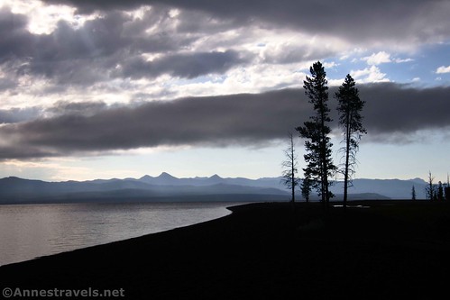
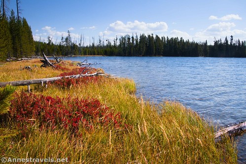
On to the Lewis River Channel Trailhead, where I hiked out to the first good trail down to the beach of Lewis Lake (2.8 miles). It was very pretty!

I spent the night on Grassy Lake Road again.
Total Miles Day 1: 7.6
Day 2: Southern Yellowstone
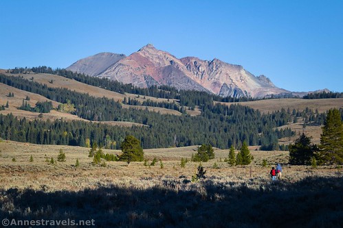
I started Day 2 with breakfast at the Snake River Picnic Area (just inside the southern entrance), and I stopped at Moose Falls again (0.2 miles) for some better pictures. Then I headed up to Riddle Lake (5.5 miles). Early morning is a fantastic time to visit, with a variety of birds, bugling elk, and some really nice people to meet.

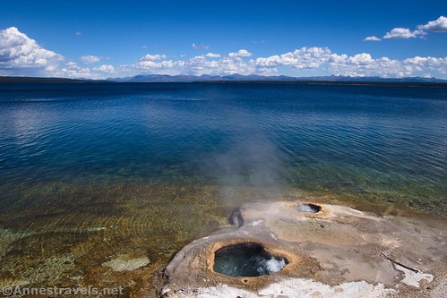
The West Thumb Geyser Basin (1.0 miles) was a highlight. Set above the lake, it’s the perfect backdrop for the geothermal pools and geysers.
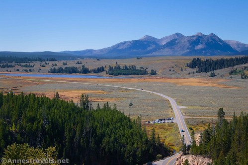
From the same parking area, I hiked up to the West Thumb Yellowstone Lake Overlook (1.9 miles). The views are gorgeous!

I finished off hiking for the day with a quick zip up to Duck Lake (1.0 miles) since it also departs from the West Thumb parking area.

Again, I stayed on the Grassy Hollow Road.
Total Miles for Day 2: 9.6
Day 3: Yellowstone Lake
To start the day, I worked my way up the shore of Yellowstone Lake, starting in West Thumb. I did stop at Pumice Point and the Spruce Fir Exhibit, but my first hike was from Sand Point Picnic Area down to the shore of Yellowstone Lake. It’s a delightful trail with good views from the lakeshore, but I forgot to set the GPS. So I’m guessing it was about a half a mile RT.
In the same vein, I drove the Gull Point Drive out to Gull Point (which had some of the worst potholes I saw in my entire trip to Yellowstone!) Again, I walked down to the lakeshore – the views are better from here of Fishing Bridge and the nearby lodge. I’d guess that hike was close to 0.25 miles.

At the very end of Gull Point Drive, another camper and I both pulled into the tiny parking area at the same time so that we could hike to Yellowstone’s Natural Bridge (2.6 miles). There’s room for two vehicles at this trailhead, so we were both happy to have secured a spot!

I played the tourist to walk across Fishing Bridge (the sun just didn’t cooperate, but oh well) (0.4 miles), took the somewhat disappointing Pelican Point Nature Trail (neither a nature trail nor with much in the way of views) (0.9 miles), and then hiked up Elephant Back Mountain (4.3 miles). If you only have time for this or the overlook in West Thumb, there’s no question that the West Thumb hike is better, but I did enjoy the somewhat peek-a-boo (but spectacular) views out over Yellowstone Lake.

The skies didn’t look promising, but we dodged raindrops to drive up to the LeHardy Rapids Boardwalk (0.5 miles) (on the way between Fishing Bridge and Canyon). The ducks were adorable and so fun to photograph!

I spent the night outside of West Yellowstone.
Total Miles for Day 3: 9.5
Day 4: Central Thermal Areas
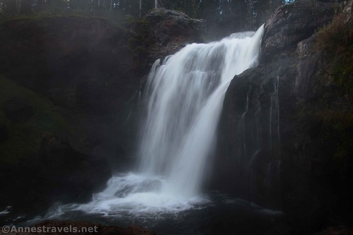
The Firehole Canyon Scenic Drive was my first order of business (after breakfast at the Madison Picnic Area) on Day 4. I stopped at Firehole Falls, but the Firehole Swimming Area was closed for the season. However, I did pull off just after the end of the scenic drive to see the Cascades of the Firehole (0.2 miles). The mist was lifting over the falls – gorgeous!

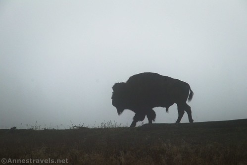
Fountain Flat was very misty that morning; I stopped at Maiden’s Grave Spring (0.1 miles) and ended up taking more pictures of bison silhouetted by the mist than I did of the spring.
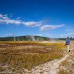
Then it was off on the Fountain Flat Freight Road. When we came to the turnoff for Sentinel Meadows and Queen’s Laundry, there were too many bison blocking the path, so we did the loop from the other direction (Imperial Meadows first). Somehow I missed Queen’s Laundry altogether (who knows? It wasn’t the mist since it lifted shortly after we left the fright road), and there were still too many bison when I came back to the end of the loop. Off the trail and stay away, even when one decided to walk right at us (he wasn’t angry; I think he knew we’d move!) (Total miles: 5.5)

I did the Fountain Paint Pots (0.75 miles) in the afternoon (parking was awful). I would have liked to do the Firehole Lake Drive, but it was closed. People were obviously walking or biking it, but I decided to leave that for another trip and went down to Midway Geyser Basin (0.75 miles). Again, parking was a nightmare. If I’d realized it, I’d have parked along the road and walked (there are spaces set aside for this). But patience paid off, and we got a nice parking space without wracking up too many extra miles.

I slept outside of West Yellowstone for a second night.
Total Miles for Day 4: 7.3
Day 5: Grand Canyon, South Rim
On the way into the park, I stopped at Gibbon Falls (0.6 miles) and had breakfast along the Virginia Cascade Scenic Drive (the waterfall is almost impossible to see, and there are very few places to conveniently park, so I ended up walking back a total of 1.75 miles, but I won’t count that toward my total).

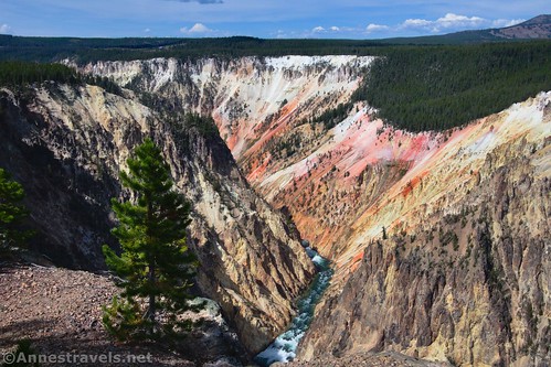
Then it was on to the Wapiti Lake Trailhead, just across the bridge onto the southern side of Yellowstone’s Grand Canyon. I decided to take the loop option, up toward Clear Lake, past Lily Pad Pond, and out onto the trail to Point Sublime. I hiked out to the point, then back to Artist Point and along the South Rim Trail to return to the trailhead. It was 7.5 gorgeous miles of trail!
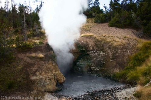
I wanted to sleep outside the Eastern Entrance in one of the hard-sided-only National Forest Service Campgrounds, so I convinced my group to stop at Sulphur Caldron (0.1 miles) and the Mud Volcano (0.9 miles) on the way.
Total Miles Day 5: 9.1
Day 6: Eastern Yellowstone
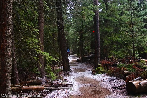
Avalanche Peak, in the eastern part of the park, has been on my bucket list for years (5.0 miles). But the eastern part of the park isn’t exactly close to the famous geothermal features, so we’ve never quite gotten around to hiking it. Even so, this day was cloudy and sprinkled with rain. I dodged the raindrops, watched the rainclouds part around my peak (!), enjoyed pockets of sunshine, and had an amazing hike!
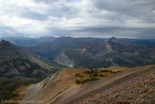
In the afternoon, I drove to the Lake Butte Scenic Drive and Steamboat Point before waiting out a thunderstorm at the trailhead for Storm Point (2.8 miles). When the sun shone, I thought I was good, so I brashly set out, navigating around the bison who didn’t even bother looking at me and grandly continued blocking the trail. Just as I got to the point, a storm rolled it. It hailed the entire way back to the parking lot, and I felt like I was in a winter wonderland with hailstones bouncing off my hat!

With more rain in the forecast, I called it a day and drove out to sleep outside of West Yellowstone.
Total Miles for Day 6: 7.8
Day 7: Geysers!
The morning was extremely misty down by Biscuit Basin (though I hear that not so far away it was nice and sunny). I hiked through the basin and on to Mystic Falls, then continued the overlook loop (nothing to see except whiteness out there at the viewpoint!) The mist began to lift as I walked through the rest of Biscuit Basin to the trailhead. (Total miles: 4.0)

The sun was shining brightly by the time we arrived at the trailhead for Lone Star Geyser (4.9 miles). I met a group of ladies who enthused over the 30-minute show they’d just experienced, complete with towering plumes of water and rainbows in the blowing mist. Doing the calculations, I figured I could walk quickly out to the geyser in time for its next eruption. Sadly, after its famous pre-show, the geyser gave a half-hearted 5-minute attempt at spouting and then subsided. I call that an excuse to go back someday!

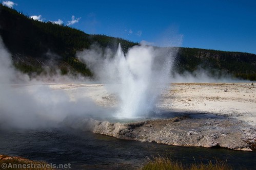
I ran out to Kepler Cascades, and then I made a quick stop at Black Sand Basin (0.6 miles). One of the geysers was going crazy, so that was fun.
Per me, you can’t go to Yellowstone and not see Old Faithful. I’d just missed an eruption, so I scouted out the best lighting and then wandered around (2.4 miles) until about 20 minutes before the next scheduled eruption. Thanks to a generous teen, I had a front-row seat as we waited… and waited… and waited… but it finally went off! And those are some of the best pictures of Old Faithful I’ve ever taken!

One last time, I stayed outside of West Yellowstone.
Total Miles Day 7: 11.9
Day 8: Up to the North
Day 8 was a weird day, but it had a lot of nice sights. I began at Terrace Springs (0.2 miles), then moved on to Beryl Spring (0.1 miles) and Monument Basin (3.25 miles). The last was probably my biggest disappointment in Yellowstone; I’d read great things about it, but it turned out to be a lot of uphill for not that much excitement. The smoking stacks were cool, though.
Artists’ Paint Pots (1.1 miles) were fun to see, then we stopped at the Chocolate Paint Pots (where I stepped in the wrong place and ended up to my knee in iron-rich mud; I’m pretty sure my hiking sock will never be the same).

From there, I passed by the Norris Geyser Basin (3.0 miles) and headed up to Frying Pan Spring (0.25 miles), Nymph Lake, the Twin Lakes, Roaring Mountain (which wasn’t roaring or smoking and Lemonade Lake was dry), Centennial Geyser (0.1 miles), Clearwater Spring (0.1 miles), and finally Sheepeater Cliff (1.6 miles). I hiked down to the cliff, then down to the “Chute” waterfall, then continued on to find a social trail down to river level. It’s a pretty area!

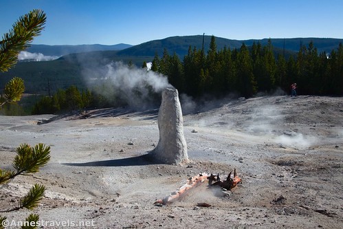
Swan Lake offered a gorgeous view and a trail down to the lake (I didn’t count it; probably 0.5-0.75 miles), and then it was down past Rustic Falls, Golden Gate Canyon Overlook, and Silver Gate to Mammoth Hot Springs (2.3 miles – at least the way I did it!)

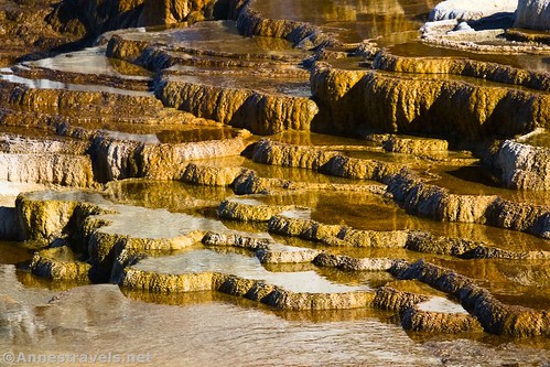
I’ve done Mammoth Hot Springs several times before, and it’s always a bit of a gamble. You never know if you’re going to find dozens of gorgeous terraces or only one small section of color and the rest are chalk-white. This time, there was a nice mix, with Canary Spring, Minerva Terrace, and Palette Springs working overtime to create lovely terraces.

I hiked from the top down to Canary Spring, then back up and down to Minevra, the Liberty Cap, and Palette (and of course back up all that way to the top where I’d parked!)
I planned to sleep outside of Gardiner (north entrance), but I was very surprised to drive out and find the road in a remarkably different place than the maps I’d printed off the internet said it should be. In fact, my road GPS said I was driving through fields, not on a road at all! It turns out that in June 2022 remarkable amounts of snowmelt combined with unprecedented rainfall to create flooding and havoc throughout the park. The north entrance road was so badly damaged (it ran right along the Yellowstone River) that the park service decided to build an entirely new route on the foundation of an old carriage road. Hopefully, they’ll fix the old road enough in the future to allow access to the trailheads that are currently inaccessible.
Total Miles for Day 8: 8.9
Day 9: Northwest Yellowstone
I hadn’t planned to take the Terrace Mountain Loop (7.25 miles), but it turned out to be spectacular through meadows and “the Hoodoos” (large rocks) – not to mention quite a bit of elevation gain.
In the afternoon, I did the unrewarding hike on the Lava Creek Trail to Undine Falls (1.0 miles), a much better hike to the lovely Wraith Falls (0.9 miles), Forces of the Northern Range Nature Trail (which is a leftover from just after the 1988 fire) (0.6 miles), the Blacktail Plateau Scenic Drive, and the Petrified Tree (0.2 miles), with a quick stop at the official Undine Falls Viewpoint (which had a much better view of the falls than the other side of the creek) just before dark.
Again, I stayed outside of Gardiner.
Total Miles for Day 9: 9.9
Day 10: Northeast Yellowstone
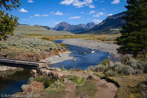
I had my day mapped out, but it didn’t work out very well. Many of the trails I’d planned (Lewis Falls, Lewis Lake, Yellowstone Picnic Area, etc.) were closed, either for trail construction or road construction (there’s a new bridge going in just north of Tower, and all of the trailheads and picnic areas have been commandeered for staging areas). Sooooo, I headed up toward the Lamar Valley. I’m so glad I did. The Lamar RiverTrail (7.3 miles) was spectacular, with so many bison and even a few pronghorns.

I did a quick (if steep) hike to Trout Lake (1.4 miles) and ended the day at the Fossil Forest (3.0 miles), one of the craziest, steepest trails I attempted in Yellowstone (it was downright dangerous!) But the views were great, and we did find the fossil forest, so there’s a lot to be said for it!

I was readying myself up for one last day, so I stayed one last time outside of Gardiner.
Total Miles for Day 10: 11.7
Day 11: Grand Canyon, North Rim
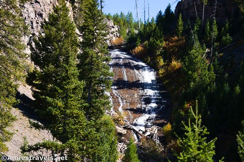
I’d been trying to get back to hike the north rim of the Grand Canyon of the Yellowstone River, but it simply hadn’t worked (I’ll blame that on a lack of outside-the-park camping anywhere in the vicinity). It was one trail I did not want to leave the park without hiking. So I headed south via Calcite Springs Overlook (0.4 miles) and a couple of small viewpoints. I also decided I really wanted to see Ice Lake and Little Gibben Falls as a loop (4.1 miles). I’m not sure it was really worth it, but the lake was lovely, and I saw two loons. The best part – at least for me – was that I heard a real, honest-to-goodness wolf howl!
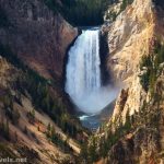
And then it was on to our last hike – the north rim of the Grand Canyon, beginning at the Wapiti Lake Trailhead once again (7.7 miles). It started off nice and sunny, but the rain began about the time we made it to the Brink of the Upper Falls (in other words, we’d barely begun). One of my group members ran back for the van, and I ran back down to the Brink of the Upper Falls to get pictures of the post-storm rainbows in the mist off the falls.

We donned our rain jackets (I knew I packed them for a reason!) and headed off down the trail. The rain returned about the time we headed down to the Brink of the Lower Falls, and we survived the worst of the thunderstorm down by the river with a few other groups of tourists who didn’t mind getting wet (our rain jackets kept us remarkably dry). The rest of the afternoon was a game of rain vs. clouds vs. sunshine, but the hike itself was spectacular. Definitely a must-do if you go to Yellowstone!

I got back to the van, tallied up our miles to over 100, and proclaimed Yellowstone a rousing success! So much so that we spent the night along the Grassy Hollow Road so we could go to the Tetons for our last day instead of hiking any more miles in Yellowstone…
Total Miles for Day 11: 12.2
Total Miles for all 11 days = 105.5 miles!
Afterward
There are three trails I’m (only slightly) sad I couldn’t do on this trip: 1) Bunson Peak/Osprey Falls (10.0 miles), 2) Seven Mile Trail (9.7 miles), and 3) Observation Peak (9.3 miles). I also really wanted to do Black Canyon of the Yellowstone (up to a 21.4 mile shuttle), but it just didn’t work out. You really don’t want to miss Norris Geyser Basin (3.0 miles), the further reaches of the Upper Geyser Basin, (3.5+ miles), and the Grand Prismatic Spring Overlook/Fairy Falls (5.25 miles). I’d hiked these recently enough to feel I didn’t need to do them on this trip. One other major trail I skipped for having already done it was Mount Washburn (5.6 miles) (which was closed due to grizzly activity during my visit).

Be sure to give yourself extra time for parking in popular areas, being stuck in bison jams along the roads, and simply slowing down to enjoy the view. They say that if you need to estimate how long it will take you to get somewhere in Yellowstone, take the number of miles, double it, and that should be the number of minutes it will take to drive. (For example, if it’s 10 miles, it will probably take you 20 minutes to drive.)
Remember to stay on trails and boardwalks and stay away from wildlife. I found the bison to be extremely arrogant – they know they rule the pecking order, including humans, and they don’t give a fig that you happen to be in their way or that you might be trying to get somewhere other than your current position (the Lamar Valley bison were much less stuck on themselves). The elk were in some ways more dangerous because they do take an interest in people (at least in Mammoth). In fact, rangers walk around Mammoth with bullhorns to warn off the tourists whenever the elk start moving.
I stayed outside of Yellowstone National Park. This meant considerably more driving, but I hadn’t planned in advance and therefore couldn’t get a campsite in the National Park Service campgrounds. If you’re planning further in advance than me, you can reserve campsites or lodging on recreation.gov.

This Week’s Featured Product!
Explore beautiful scenery in Yellowstone and beyond with this guide designed to lead you to and through amazing views. Buy your copy here!

More Related Posts:
 Epic Day Hiking Road Trip to Yellowstone & Grand Tetons!
 Biscuit Basin, Mystic Falls, and Biscuit Basin Overlook
 The Best Hikes for Kids in Yellowstone National Park
 Hiking the Sentinel Meadows Loop
 12 Best Day Hikes in Grand Teton National Park
 South Rim Trail Loop above Grand Canyon of the Yellowstone
One response to “How I Hiked 100 Miles in Yellowstone National Park in 11 Days”
[…] couple of weeks ago, I wrote about my trip to Yellowstone National Park. While I was out there, I decided to tack on a couple of extra weeks to explore new places. In […]