

If you’re looking for a quiet little loop hike not too far from the main attractions of Yellowstone National Park, Ice Lake (with Little Gibbon Falls) is a good choice. You’ll get a pretty little lake, peaceful forests, and a small waterfall that seem miles away from the hustle and bustle of the main road between Canyon and Madison. The loop also has a few campsites, so if you can snag one, you can enjoy all of the early morning and late evening birds and other wildlife, too, around the lake.
Quick Stats

Note: To complete this hike as a loop, you’ll need to walk 0.4 miles along the main park road. For the most part, there is a wide enough ditch next to the pavement that it’s fairly safe, but it still is by far not my favorite part of the trek.

The path to Little Gibbon Falls begins at the Wolf Lake Trailhead. From the parking area, walk downhill down the road toward the bridge. Before reaching the bridge, you’ll see the trail heading left (on the north side of the road) into the woods. Once in the woods, there is a classic Yellowstone trailhead map sign (I love these!)

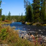
The Wolf Lake Trail meanders slightly uphill through the forest, usually with the Gibbon River fairly close on your right. Pass through Virginia Meadows (which can be muddy and buggy in early summer).

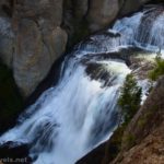
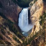
Only 0.7 miles from the trailhead, you’ll come across Little Gibbon Falls. At only 25ft. high, it’s not exactly the most impressive cascade I’ve ever witnessed. Because of this, unless you just love waterfalls, I wouldn’t stay it’s a destination unto itself. But it’s a great view along the longer loop. Most of the views of Little Gibbon Falls are peek-a-boo through trees on the bluff above the river. The trail drops down to river level, so you can also get some good views of it from above.
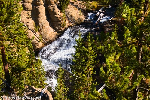
So I read, the original name of the cascade was Upper Falls of the Gibbon. In 1939, John Seamans was doing his normal fish-researcher work when he came upon the waterfall. He renamed it Little Gibbon Falls due to its micro-scale similarity to the much larger Gibbon Falls downstream. His name stuck.

Right after passing Little Gibbon Falls, you’ll need to cross the Gibbon River. This is fairly easily accomplished (be sure to look upstream at some interesting cliffs), and the path continues through the trees. The forest was badly burned during the 1988 fire, so most of the pines are new growth.

About 1.5 miles from the trailhead, the path splits with the Wolf Lake Trail continuing straight to Wolf, Grebe, and Cascade Lakes, while the path to Ice Lake turns left. Turn left. The next section of trail is interesting – there is quite a bit of deadfall, but some of the burned-out trunks are interesting. It’s quite a contrast of gray fallen trees, burned wood, and bright green, dense new growth. Even more interesting is trying to cross the Gibbon River one last time. It’s really not that bad, but we managed to lose the trail in the process. We found it again without too much striking around for it.

Approximately 0.8 miles from the last trail junction, you’ll come to a campsite junction on the left (4D2). This marks the beginning of Ice Lake, which is just visible on the left through the trees. Don’t worry; views get better.

I ducked down a social trail to the edge of the lake for photos, but the best vantage point I found was at a campsite at mile 3.0 (about 0.7 miles from the first campsite trail junction). This campsite (4D1) is down a trail on the left, right on the edge of the lake.

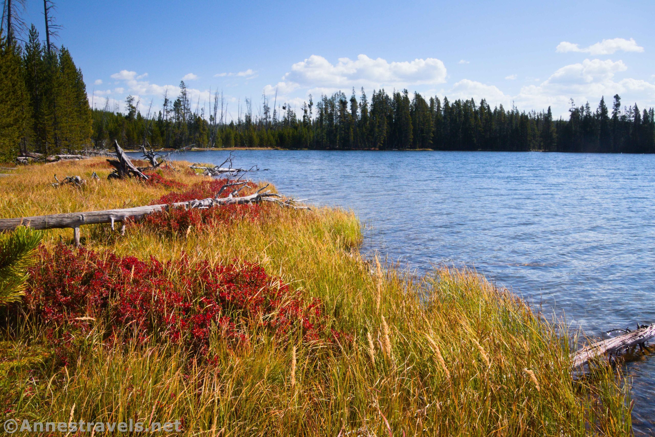
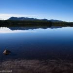
Views of Ice Lake in the autumn were lovely. The grass along the edges has turned golden, and small bushes are brilliant red. Contrasted against the green fir trees and the deep blue reflections of the sky, it’s an almost breathtaking scene.

I also spotted a pair of loons on the lake. I’ve been trying to photograph loons for a long time, and while these didn’t turn out very well, either, they’re better than most of my attempts!

One of the things I was really hoping to see on our visit to Yellowstone was a wolf. Despite all of my travels, I’ve yet to see a wolf in the wild. This was our very last day in Yellowstone, and while I’d seen bison, antelope, a coyote, ducks, loons, and other wildlife, no wolves had made an appearance. In fact, I’d almost forgotten my desire in my thankfulness for all of the amazing things we’d done and seen. As we hiked further along the shore of Ice Lake, a very canine howl broke the stillness, somewhere quite a distance away on the left. It’s got to be a coyote! I thought. It can’t possibly be a real, honest-to-goodness wolf! But I know what coyotes sound like (they howl at the 11:30pm plane over my house every night), and that definitely was not a coyote. So I left Yellowstone without seeing a wolf, but I sure heard one – how cool is that?!
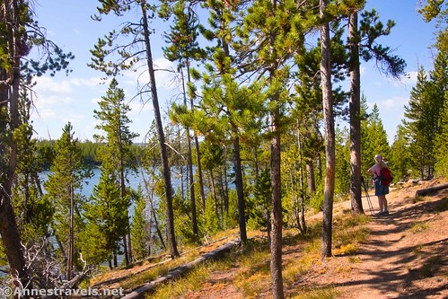
The views along the Ice Lake Trail are mostly peek-a-boo through the trees up to the junction with the Howard Eaton Trail about a tenth of a mile beyond the campsite with good views. Turn left here toward the Ice Lake Trailhead (turning right would take you to Norris).

Views open up a little along this end of the lake as you hike by. However, you’re also further from the lakeshore, so unless you like balancing on dead logs, you’re better off enjoying the view from the trail.

Half a mile later, a trail to the final campsite (4D3 – handicap accessible) is on the left. The views from this campsite would also be gorgeous. However, it looked like someone was having a lovely, quiet time there, and since I didn’t want to disturb her, I continued toward the trailhead, 0.7 miles away through the trees.

Again, you’ll see the classic Yellowstone trailhead map sign. You’ll also emerge to see cars whizzing by. So much for the peacefulness of the trees! From here, you’ll need to turn left down the road to hike back to the Wolf Lake Trailhead. It’s not the most pleasant of hikes due to the traffic (there is a shoulder, though not much of one), but it’s totally doable. We had the advantage of road construction, which meant that there were considerable breaks in traffic. It was also a disadvantage since the pavement had no markings and the drivers hugged the shoulder more than if the white line had been visible.

About 4.1 miles after leaving your vehicle, return to the Wolf Lake Trailhead. You can breathe a sigh of relief to be back off of the road before finding another Yellowstone adventure!

Round Trip Trail Length: 4.1 mile loop; you can cut 0.4 miles off of the hike with a shuttle vehicle
Elevation Gain: 517ft. (7,796ft. to 8,011ft.)
Facilities: None
Fees: $35/vehicle, valid 7 days. Yellowstone Annual and National Park & Federal Lands Passes are accepted.

Trail Notes: Due to the road portion of the loop, it’s not really suitable for young children (we would have solved that problem by sending one adult along the road to pick up the van while the rest of us waited at the last trailhead). This would be a great place to hike in the early morning or late afternoon for the best chance of seeing wildlife. Virginia Meadows is a favorite place to fish, though there are several places along the trail that would be suitable for fishing.

Trail 
![]()
Road ![]()
Signs
Scenery ![]()
![]()
Would I go 100 miles out of my way for this? ![]()
![]()
Overall Rating: ![]()

GPS Coordinates for Ice Lake
Wolf Lake TH: 44.7127090°, -110.6269190° (44°42.76254′, -110°37.61514′ / 44°42’45.7524″, -110°37’36.9084″) (7,799ft.) (0.0)
Little Gibbons Falls: 44.7162540°, -110.6158770° (44°42.97524′, -110°36.95262′ / 44°42’58.5144″, -110°36’57.1572″) (7,872ft.) (0.72)
Wolf Lake Junction: 44.7213360°, -110.6075960° (44°43.28016′, -110°36.45576′ / 44°43’16.8096″, -110°36’27.3456″) (7,984ft.) (1.50)
Campsite Junction: 44.7227090°, -110.6203400° (44°43.36254′, -110°37.22040′ / 44°43’21.7524″, -110°37’13.2240″) (7,907ft.) (2.29)

Campsite: 44.7224440°, -110.6320470° (44°43.34664′, -110°37.92282′ / 44°43’20.7984″, -110°37’55.3692″) (7,896ft.) (2.97)
Howard Eaton Junction: 44.7234400°, -110.6344680° (44°43.40640′, -110°38.06808′ / 44°43’24.3840″, -110°38’04.0848″) (7,901ft.) (3.16)
Campsite Junction: 44.7183660°, -110.6341550° (44°43.10196′, -110°38.04930′ / 44°43’06.1176″, -110°38’02.9580″) (7,984ft.) (3.60)
Ice Lake TH: 44.7168650°, -110.6339430° (44°43.01190′, -110°38.03658′ / 44°43’00.7140″, -110°38’02.1948″) (7,881ft.) (3.73)
Wolf Lake Parking: 44.7133170°, -110.6286690° (44°42.79902′, -110°37.72014′ / 44°42’47.9412″, -110°37’43.2084″) (7,818ft.) (4.11)

The gpx file for Ice Lake can be downloaded – please note that this and the GPS Coordinates are for reference only and should not be used as a sole resource when hiking this trail.
Download GPX File size: 64.4 KB Downloaded 485 times
(Note: I do my best to ensure that all downloads, the webpage, etc. are virus-free and accurate; however, I cannot be held responsible for any damage that might result, including but not limited to loss of data, damages to hardware, harm to users, from use of files, information, etc. from this website. Thanks!)

Getting to the Ice Lake Loop (Wolf Lake) Trailhead
From Canyon Junction, turn onto the road for Norris. After 7.8 miles, parking for the Wolf Lake Trailhead will be on your left.
From Madison Junction, drive north on US-89 toward Norris and Mammoth. After 13.3 miles, turn right toward Canyon. The Wolf Lake Trailhead will be on the right after 3.8 miles.
If you’re trying to get to the Ice Lake Trailhead instead, it’s 0.4 miles west (toward Norris) on the opposite side of the road from the Wolf Lake Trailhead.

Today’s Featured Product!
Explore Yellowstone National Park, Grand Teton National Park, and beyond with this guide to some of the best Wyoming has to offer! Buy your copy here.


One response to “Ice Lake & Little Gibbon Falls”
[…] Overlook (0.4 miles) and a couple of small viewpoints. I also decided I really wanted to see Ice Lake and Little Gibben Falls as a loop (4.1 miles). I’m not sure it was really worth it, but the lake was lovely, and I saw […]