
In general, I prefer the north rim of the Grand Canyon of the Yellowstone to the south rim (the views are just plain better from the north rim IMO). But the south rim offers a loop that blows the north rim’s offerings out of the water in terms of variation. On this hike, you’ll get quiet meadows, alpine lakes, mountain views, an active geothermal basin, views into the Grand Canyon of the Yellowstone, vistas of three separate waterfalls, and more – all in 7.5 miles!
Quick Stats
(This post contains affiliate links – there is no extra cost to you, but I may receive a small commission if you click and link and buy something.)

The path begins at the Wapiti Lake Trailhead. Make your way over to the signs (visible from the restroom). Be sure to take the left (as you’re facing the sign) Wapiti Lake Trail toward Clear Lake, Ribbon Lake, etc. – you do not want to take the right of the two trails, which is the Howard Eaton Trail heading for Fishing Bridge.

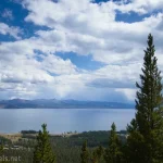
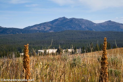
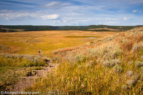
The path passes through a few trees before breaking out into open meadows. I love meadows – especially fall-yellow meadows – so this was dreamland for me. Be sure to look a little to the left to spot the fire lookout on top of Mt. Washburn as the trail rises to a trail junction.
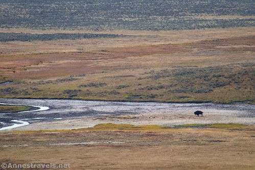
About mile 0.5, the path to Ribbon Lake strikes off to the right. Turn left toward Clear Lake. The views continue to be excellent, especially of the meadows. At least one trail goes off on the right to a viewpoint over the valley below. I spotted a bison down by the creek (which is the outlet of Ribbon Lake and – as far as I can find on maps – doesn’t have an official name).
Shortly before mile 1.0, the path begins to descend into the forest. Just over 1.0 miles from the Wapiti Lake Trailhead, the path joins the Clear Lake Trail from the Uncle Tom’s Trailhead along the South Rim Drive. If you want to make your hike shorter – and you don’t mind missing out on the meadows and some walking along the rim of the Grand Canyon later – you can cut a total of 1.3 miles off of your hike by starting there. (Or if you can’t find parking at Wapiti Lake Trailhead, this is another option – you can still do the entire loop from there; you’ll just need to go over to the Upper Falls Viewpoint to start the loop.) Turn right to continue descending.
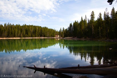
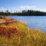
Quite quickly after this (by my expectations, anyway!) you’ll arrive at the shores of Clear Lake about mile 1.25. It’s a nice lake – I hear there is geothermal activity in its depths – and I also enjoyed seeing several ducks.

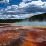
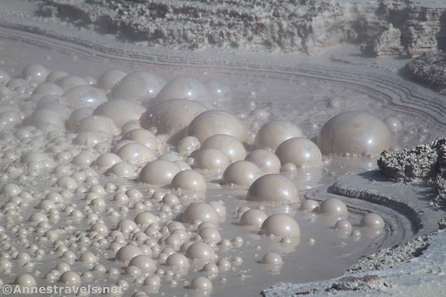
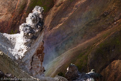
The path continues around the south and east sides of Clear Lake, mostly staying in the fringe of forest. And then, quite to my surprise, only two-tenths of a mile later we found ourselves in a geyser basin! Besides the typical lack of trees and bleached earth, there was also water vapor puffing from holes in the ground.

I hear the basin is called Forest Springs. There aren’t any colorful hot springs, and if there are geysers, they weren’t acting up when I was there. But there was a bubbling mudpot that was fun to watch.
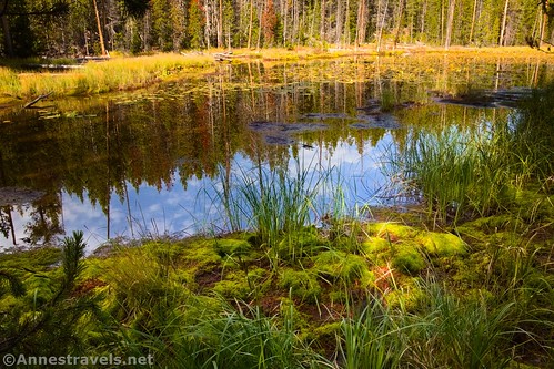
The geyser basin ends as quickly as it began after about 0.4 miles. A tenth of a mile beyond the end of the geyser basin, you’ll come to the trail junction for Ribbon Lake (many trails lead to Ribbon Lake). Turn left and pass by Lily Pad Pond.
The trail continues through the forest for about 0.3 miles to end in a T at the Point Sublime Trail. At this point, turn right for a very short distance to go out to a small, unofficial viewpoint. Per me, this was the best view I saw along the entire Point Sublime Trail.

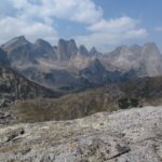
At this point, you get to make a choice. I decided to turn right and hike out to Point Sublime. There were some great views of Grand Canyon of the Yellowstone along the way. But there are also nice views by turning left toward Artist Point. So if you don’t want to add the 0.8 miles each way (1.6 miles total) out to Point Sublime, you won’t have missed too much.
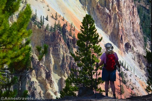
I did want to get out to Point Sublime. Some years earlier, I’d written a book about hiking in Wyoming, and reading about the two trails along the rims of Grand Canyon of the Yellowstone made me want to do both for myself. So off we trotted to Point Sublime.
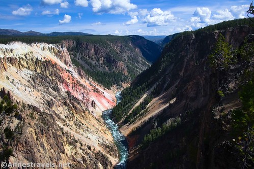
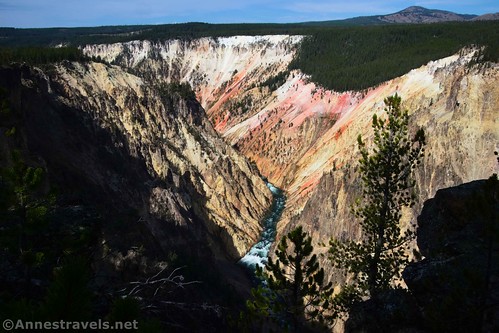
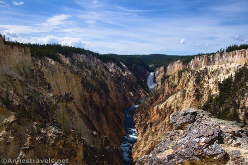
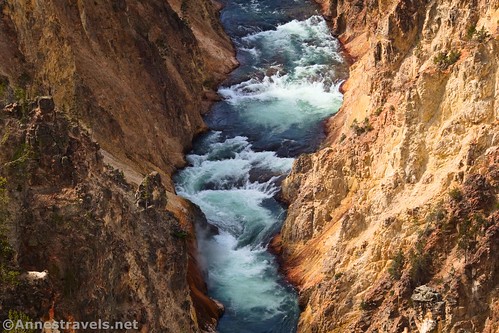
Enjoy views down into the canyon – the colorful walls, with the Yellowstone River churning in dark green and white rapids far below, are spectacular.

Unfortunately, the views along the way are better than the view at Point Sublime. Someone has kept the viewpoint clear of trees so that you can see downcanyon, or it would be much more of a disappointment. But at this point, the canyon walls have turned to black. It’s very cool, just not as pretty as the rest of the hike.

There really wasn’t anywhere to sit, especially not with anything like a good view, so we hiked back down the trail to a dead log with a view to eat lunch. That helped revive spirits for the rest of the trek back to Artist Point. The views continue to be very colorful most of the way along the path.
I finally reached the “Ribbon Lake Trailhead” (Point Sublime Trailhead at Artist Point) about mile 4.7 – and with it crowds of people! We’d had the trail to ourselves until the Point Sublime Trail, and while we’d met a few groups, it was still pretty quiet. This was mayhem!

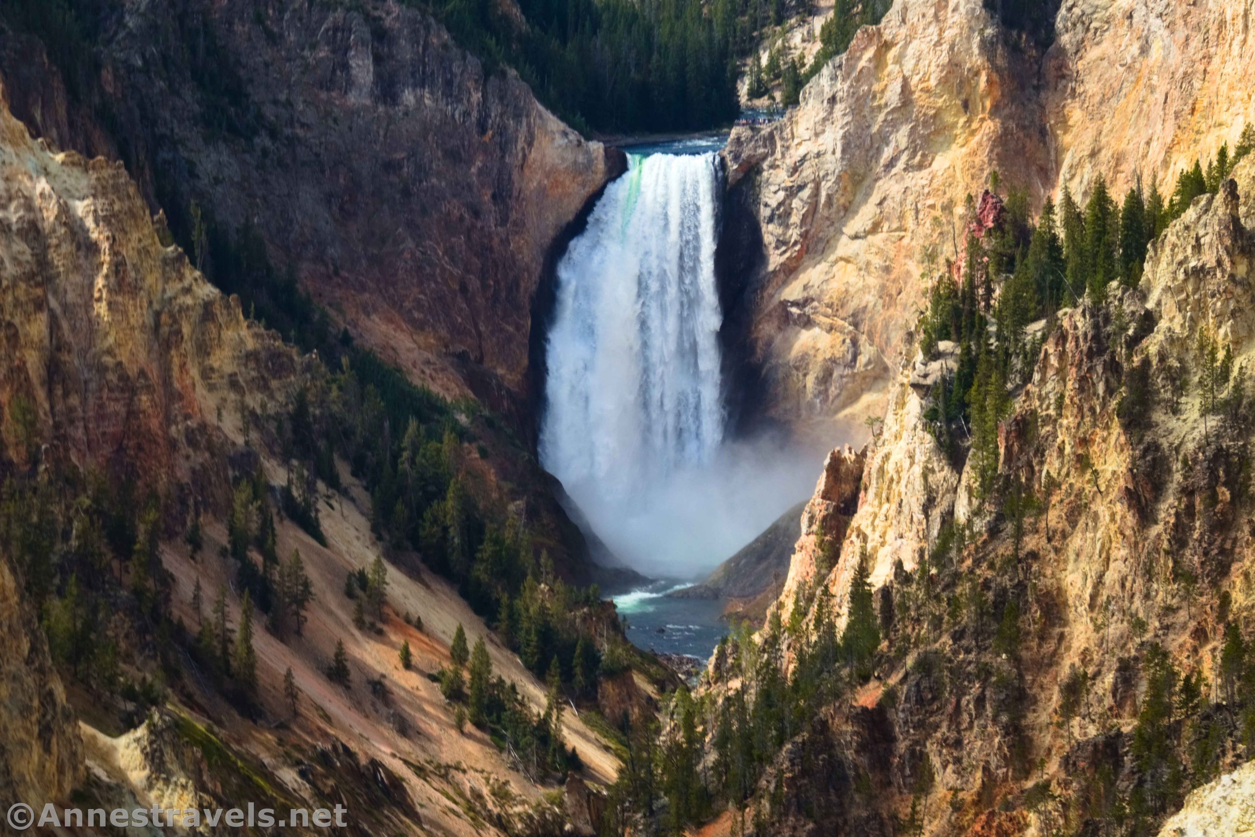
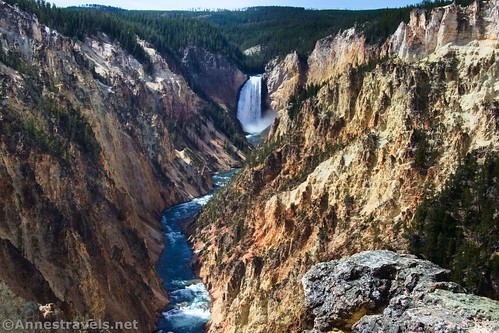
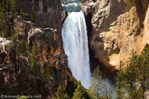
Head right over to the viewing area at Artist Point. It’s worth seeing, both for the canyon views and the views to Lower Yellowstone Falls. Spectacular!
Walk down to the parking area and then along the sidewalk beside the parking area. At the far end, you should encounter the trail heading into the woods. It seems like it was once paved, but now it’s in pretty poor repair. The park service has put up fences where the edge of the canyon is eroding away, and the trail has been rerouted in a few places. While I met more people than I’d seen on the Clear Lake Trail, it was very quiet compared to Artist Point.

About 0.8 miles from the Artist Point Trailhead, you’ll come to a small overlook. Lower Yellowstone Falls is partially obscured from view, but it’s still pretty amazing.
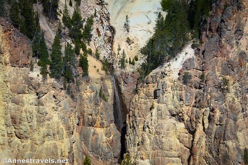
The next 0.25 miles are in the woods with very limited views, although there was a nice view to… well, I don’t know what this waterfall is called. I’ve done some research, but no one seems to talk about it.
Pass by the Uncle Tom’s Trail on the right (closed indefinitely from what I can see – pity, since it was a truly amazing view that I got to experience at least twice) at about mile 6.0; the path up to the Uncle Tom’s Trailhead is a short distance further on the left. We made the mistake of deciding to see if they had bathrooms… the restrooms were closed for the season, and on top of that, we’d have come to the restrooms with a much gentler trail if we’d just kept walking on the Rim Trail. But no, we went up, we went down, we continued on the Rim Trail, and we finally came to the Crystal Falls Viewpoint at mile 6.4. (I’d guess we lost about a quarter mile with our little detour… it felt like more.)

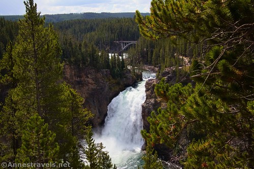
The Upper Falls Viewpoint is only a tenth of a mile further along (it’s not too far from the Uncle Tom’s Trailhead/Upper Falls View parking area). Views are nice from here of the falls as well as the Chittenden Bridge. The crowds aren’t as bad as at Artist Point. But there are still quite a few people at the Upper Falls Viewpoint.
Continue along the rim trail about another 0.3 miles to a trail on the right that leads down to a “lookout.” The short trail takes you down to a very modern overlook. The Upper Falls is mostly obscured, but it was a nice place to sit and eat a snack before tackling the final stretch of the loop.

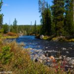
From the lookout, it’s 0.6 miles to the Chittenden Bridge. The path weaves through the forest, mostly along the riverbank with views into the Yellowstone River. It seems pretty quiet up here!

At the Chittenden Bridge, cross the road and turn left. A short distance later, a trail on the right heads into the woods. This path will take you on a shortcut up into the Wapiti Lake Trailhead.

Congratulations! That was quite the hike! We were pretty tired after all of that hiking, but it was worth it for the beautiful views and variety of scenery along the way.

Round Trip Trail Length: I went 7.5 miles – it’s probably closer to 7.25 miles without detouring up to the Uncle Tom’s Trailhead
Elevation Gain: My GPS put us at 2,395ft. of elevation gain, but that’s quite a bit more than reality, since it thinks I walked over the edge of the canyon a few times. I’d put it closer to 1,500ft. maximum (7,699ft. to 7,919ft.)
Facilities: Vault toilet at the Wapiti Lake Trailhead; seasonal restrooms at Uncle Tom’s Trailhead/Upper Falls Viewpoint
Fees: $35/vehicle, valid 7 days. America the Beautiful National Parks & Federal Lands Passes and Yellowstone Annual Passes also accepted.

Trail Notes: This hike feels longer than a little over 7 miles simply because you’ll probably keep stopping to look at one view or feature after another. The parking areas at Upper Falls View and Artist Point are both huge, but they can fill up, especially in the summer. The Wapiti Lake Parking Area also fills up, even though it has quite a few spaces. Get there early to secure a spot – if you miss this one, just park at one of the other two trailheads and pick up the loop from there. The trail does hug the edge of the canyon from time to time, and one of my group members was nervous (she doesn’t like heights) but managed ok. Quite a few social trails go off of the Point Sublime Trail – I didn’t find it necessary to take these (some are quite sketchy) to get good views.

Trail 
![]()
Road ![]()
Signs
Scenery
Would I go 100 miles out of my way for this?
Overall Rating: 
GPS Coordinates for the South Rim of the Grand Canyon of the Yellowstone Loop
TH: 44.7077540°, -110.5002620° (44°42.46524′, -110°30.01572′ / 44°42’27.9144″, -110°30’00.9432″) (7,736ft.) (0.0)
Ribbon Lake Junction: 44.7092490°, -110.4906490° (44°42.55494′, -110°29.43894′ / 44°42’33.2964″, -110°29’26.3364″) (7,874ft.) (0.55)
Clear Lake Trail Junction: 44.7124580°, -110.4826070° (44°42.74748′, -110°28.95642′ / 44°42’44.8488″, -110°28’57.3852″) (7,884ft.) (1.06)
Clear Lake: 44.7128620°, -110.4796390° (44°42.77172′, -110°28.77834′ / 44°42’46.3032″, -110°28’46.7004″) (7,820ft.) (1.23)
End of thermal area: 44.7158630°, -110.4715980° (44°42.95178′, -110°28.29588′ / 44°42’57.1068″, -110°28’17.7528″) (7,789ft.) (1.83)
Ribbon Lake Junction: 44.7167880°, -110.4703040° (44°43.00728′, -110°28.21824′ / 44°43’00.4368″, -110°28’13.0944″) (7,774ft.) (1.94)
Lilypad Lake: 44.7174150°, -110.4704230° (44°43.04490′, -110°28.22538′ / 44°43’02.6940″, -110°28’13.5228″) (7,784ft.) (1.99)
Point Sublime Trail Junction: 44.7203080°, -110.4698870° (44°43.21848′, -110°28.19322′ / 44°43’13.1088″, -110°28’11.5932″) (7,822ft.) (2.30)
Point Sublime: 44.7244600°, -110.4595380° (44°43.46760′, -110°27.57228′ / 44°43’28.0560″, -110°27’34.3368″) (7,801ft.) (3.12)
Point Sublime (Ribbon Lake) TH: 44.7209640°, -110.4788400° (44°43.25784′, -110°28.73040′ / 44°43’15.4704″, -110°28’43.8240″) (7,665ft.) (4.72)

Artist Point TH: 44.7202340°, -110.4798010° (44°43.21404′, -110°28.78806′ / 44°43’12.8424″, -110°28’47.2836″) (7,673ft.) (4.93)
Viewpoint: 44.7170860°, -110.4920660° (44°43.02516′, -110°29.52396′ / 44°43’01.5096″, -110°29’31.4376″) (7,706ft.) (5.76)
Uncle Tom’s Trail Junction: 44.7163690°, -110.4950460° (44°42.98214′, -110°29.70276′ / 44°42’58.9284″, -110°29’42.1656″) (7,695ft.) (5.99)
Trail down from parking lot junction: 44.7165240°, -110.4957800° (44°42.99144′, -110°29.74680′ / 44°42’59.4864″, -110°29’44.8080″) (7,724ft.) (6.03)
Crystal Falls Viewpoint: 44.7153960°, -110.4972830° (44°42.92376′, -110°29.83698′ / 44°42’55.4256″, -110°29’50.2188″) (7,753ft.) (6.46)
Upper Falls Viewpoint: 44.7148500°, -110.4972290° (44°42.89100′, -110°29.83374′ / 44°42’53.4600″, -110°29’50.0244″) (7,744ft.) (6.52)

Lookout Trail Junction: 44.7118630°, -110.4983350° (44°42.71178′, -110°29.90010′ / 44°42’42.7068″, -110°29’54.0060″) (7,754ft.) (6.84)
Lookout: 44.7123690°, -110.4983290° (44°42.74214′, -110°29.89974′ / 44°42’44.5284″, -110°29’53.9844″) (7,720ft.) (6.88)
South Rim Drive: 44.7081270°, -110.5022390° (44°42.48762′, -110°30.13434′ / 44°42’29.2572″, -110°30’08.0604″) (7,670ft.) (7.46)
End at parking area: 44.7080870°, -110.5011530° (44°42.48522′, -110°30.06918′ / 44°42’29.1132″, -110°30’04.1508″) (7,731ft.) (7.54)

The gpx file for South Rim of the Grand Canyon of the Yellowstone Loop can be downloaded – please note that this and the GPS Coordinates are for reference only and should not be used as a sole resource when hiking this trail.
Download GPX File size: 74.7 KB Downloaded 529 times
(Note: I do my best to ensure that all downloads, the webpage, etc. are virus-free and accurate; however, I cannot be held responsible for any damage that might result, including but not limited to loss of data, damages to hardware, harm to users, from use of files, information, etc. from this website. Thanks!)

Getting to the Wapiti Lake Trailhead
From Canyon Junction, drive south on the Grand Loop Road. After 2.3 miles, turn left, following signs for the South Rim and Artist Point (don’t confuse this junction with the North Rim Road, which turns left before this). Almost immediately, you’ll cross over the Yellowstone River via the Chittenden Bridge. Take the first right (about 0.1 mile from the turn off the main road) into the parking area for the Wapiti Lake Trail. Park in one of the many spaces provided.
The turn onto the South Rim Drive is 13.1 miles north of the junction at Fishing Bridge.

If there’s no space to park here, continue down the South Rim Drive another 0.5 miles to the Uncle Tom’s Trailhead/Upper Falls View Trailhead, on the left.

Today’s Featured Product!
Explore Yellowstone National Park, ranger-style, with this book written by two park rangers. The guide covers 34 carefully selected hikes along with photographs and commentary. Buy your copy here!