

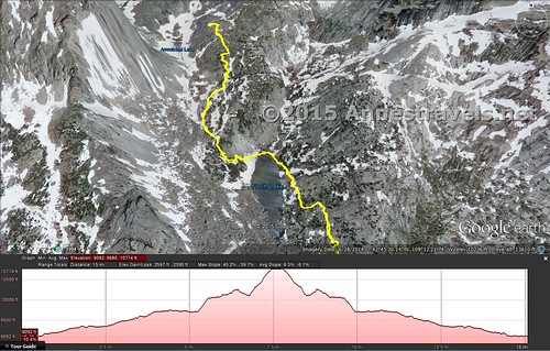
It’s a total of 8.3 miles to the Cirque of Towers Overlook in Jackass Pass, above Big Sandy Lake in the Wind River Range of Wyoming. That’s way too long to plan a dayhike for me. Way too long. But I’d been led to believe that it was only a mile from Big Sandy Lake to the end of Jackass Pass and the Cirque of Towers Overlook, so we planned for a 12-13 mile RT hike, started early, and made time on the flat sections (i.e., the first 5 miles of the trail to Big Sandy Lake).
Quick Stats
(Affiliate links are present on this page.)
Well, estimate of 12 miles was wrong. So was 13 miles. By the time I arrived back at the parking area, my GPS was reading 17.0 miles, matching our longest-ever-hike record set on the Horseshoe Mesa Loop in the Grand Canyon back in 2013. Still, this was nowhere near as hard as hiking in the Grand Canyon, and the view was so spectacular, it was worth every step. Even the one member of my group who’s usually not excited about long hikes due to achy joints and muscles more than admitted it was a doable dayhike and so worth the extra miles. In fact, she called it her favorite hike on our entire two-week stay in Wyoming. And that was saying something!
So dayhikers be aware: it’s about as hard as an average 14 or so mile hike. It’s doable as a dayhike, but only if you start early and are in good physical fitness. Because while the trail itself isn’t too difficult (most of the way, at least), it is long; 17 miles kind of long.
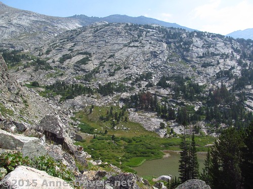
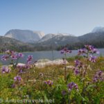
With that out of the way, here’s the rest of the story. We began by hiking the five nearly flat miles to Big Sandy Lake, walked the 0.75 miles around the lake, then turned upward into Jackass Pass, arriving at North Lake at 7.25 miles. Click the links to have a more detailed post about the trails to these via points.
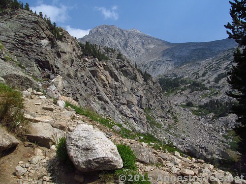
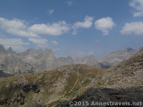
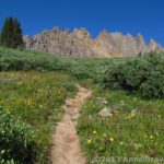
At the far end of North Lake, cross the inlet (quite easy; no need for wet feet in August) and come to the first really steep section of the trail. Yes, the switchbacks up from Big Sandy Lake into Jackass Pass got your heart pumping, but it was nothing compared to this. The trail steeply switchbacks upward, then crosses (via a good-enough trail) a very rocky section. Use care to stay on the main trail, as there are numerous social trails in this section. Most either lead back to the trail or to overlooks, but be on the lookout for cairns and the most-worn path just the same.
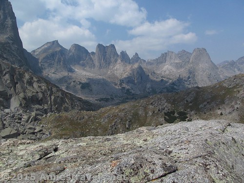
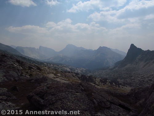
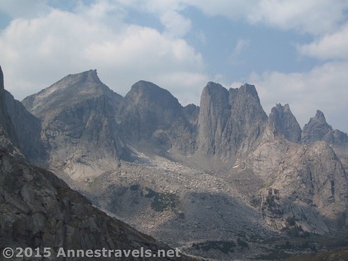
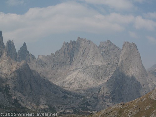
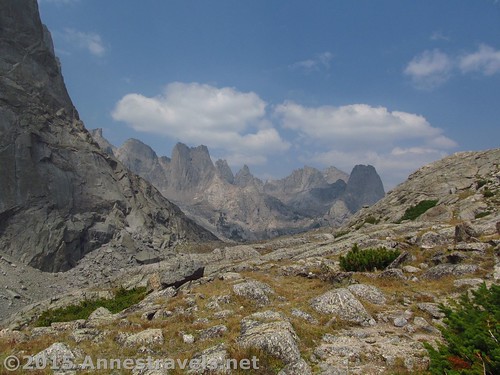
It’s only a mile from North Lake to the Cirque of Towers overlook, but it is the most difficult mile on the whole trail (you’ll be climbing about 600 vertical feet), so take your time and enjoy the views – they’re still awe-inspiring of the War Bonnet, especially, as well as Mount Mitchell and glimpses of a few of the Towers in the Cirque.
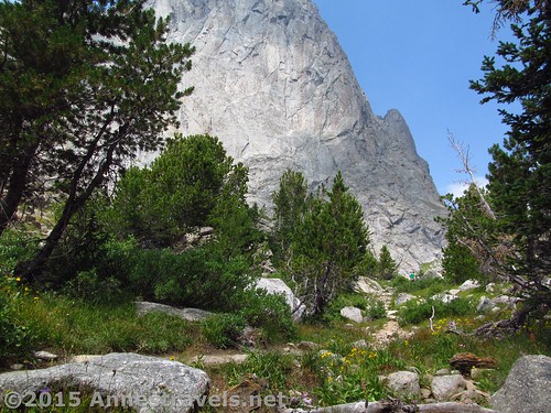
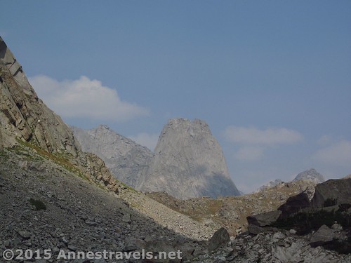
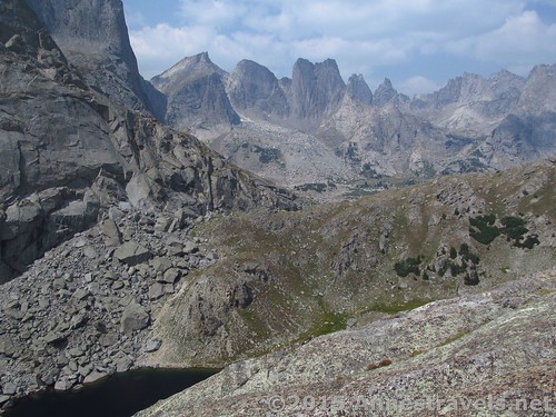
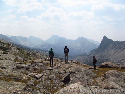
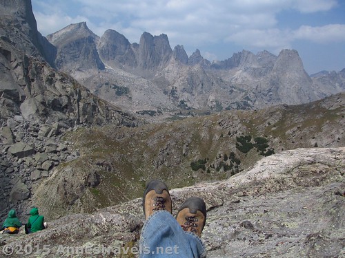
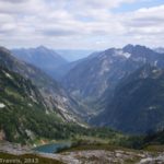
Finally, rise to the top of your climb at mile 8.25 with a very large rock on the left. From here, the trail descends quickly, the climbs a foliage-covered ridge. However, don’t descend. Instead, scramble up the rock on the left to an incredible view.
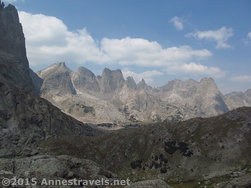
The Cirque of Towers is right there, just far enough away to be really appreciated. Arrowhead Lake is below the War Bonnet (though you have to get dangerously close to the sheer cliff edge of the rock to see it). It’s truly an incredible sight. Not really to be described as beautiful, but awe-inducing. Breath-catching. Hard to tear your eyes away grasping. Awesomeness that’s hard to describe. And the pictures simply don’t do it a bit of justice.
When you’re finally able to pick your jaw off the rock, you have two options: you can return the way you came (like I did – after all, 16.6 miles is a terribly long dayhike for me), or you can continue over that last ridge into the Cirque itself.
Take your pick. The option is up to you.
Round Trip Trail Length: 16.6 miles, although my GPS was reading 17.0 at the end of the hike
Lowest Elevation: 9,095 ft.
Highest Elevation: 10,785 ft.
Net Elevation Gain: 1,690 ft.
Facilities: Restrooms at the trailhead. No drinking water available at the trailhead – come prepared!
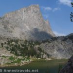
Trail Notes: The Cirque of Towers is the most popular area of, as well as one of the most popular gateways to, the Wind Rivers, for climbers, backpackers, and dayhikers alike. You’ll have plenty of company on this trail.
Fees: None
Trail 
![]()
![]()
Road ![]()
![]()
Signs ![]()
![]()
Scenery
Would I go 100 miles out of my way for this?
Overall Rating: ![]()
Key GPS Coordinates
Arrive at North Lake: 42.75680N / -109.20596W (42° 45′ 24.4794″ / -109° 12′ 21.456″) (10,115ft.) (7.2)
End of North Lake; trail begins steep uphill: 42.75702N / -109.20737W (42° 45′ 25.2714″ / -109° 12′ 26.5314″) (10,119ft.) (7.3)
Leave the Trail at Top of Jackass Pass: 42.76360N / -109.20915W (42° 45′ 48.9594″ / -109° 12′ 32.9394″) (10,762ft.) (8.2)
Cirque of Towers Overlook: 42.76373N / -109.20942W (42° 45′ 49.428″ / -109° 12′ 33.9114″) (10,785ft.) (8.3)
The gpx file for the Cirque of Towers Overlook can be downloaded – please note that this and the GPS Coordinates are for reference only and should not be used as a sole resource when hiking this trail.
GPX Download File size: 399.3 KB Downloaded 831 times
(Note: I do my best to ensure that all downloads, the webpage, etc. are virus-free and accurate; however, I cannot be held responsible for any damage that might result, including but not limited to loss of data, damages to hardware, harm to users, from use of files, information, etc. from this website. Thanks!)
Getting to the Trailhead
From Pinedale, WY, take US-191 South for almost 12 miles to WY-353 E. This is next to the Boulder Store in the “town” of Boulder. Turn left onto WY-353 E and drive 15.5 miles; continue straight on Big Sandy / Elkhorn Road for an additional 11.8 miles. (The road turns to dirt somewhere in this area.) Not long after crossing the river, turn left, following the sign for Big Sandy Opening, onto Lander Cutoff Road. After 7.0 miles, turn left onto Big Sandy Opening Road (again following the signs for Big Sandy Opening). Stay on the main road to the Big Sandy Opening Trailhead a little over 10.5 miles later.
From I-80, take Exit 104 toward Rock Springs. Turn north on US-191 North and drive 38.5 miles. Turn right onto WY-28 E, following the signs for Lander. After 33.3 miles, turn left onto dirt Lander Cutoff Road for 24.8 miles. If ever in doubt about which road to take, stick with the main one; all the major intersections are signed (or at least should be!) Turn right onto Big Sandy Opening Road (signed) and arrive at the trailhead a little more than 10.5 miles later.
From Lander, head south on US-287 S for 9 miles; continue straight onto WY-28 W. After 33.1 miles, turn onto dirt Lander Cutoff Road, and follow the directions above (Rock Springs directions) to Big Sandy Opening Trailhead.
All the roads in this area are dirt. Taking the ones I’ve recommended, the roads are in quite good condition (the Big Sandy Opening Road has some potholes / rocks – and there’s always washboard – but considering the number of low clearance vehicles at the trailhead, it can’t be too bad). However, GPSes don’t necessarily take good roads vs. bad roads into consideration – ours consistently told us to turn on the California Trail, which is just a single track heading out across the scrubland with an occasional fence across it, as well as a number of two-sandy-tracks-in-the-sagebrush roads. Don’t be deceived – stick with the main, well-maintained roads!
Oh, and the views approaching the Wind Rivers from the west are outstanding!
Zoom map out to browse nearby hikes & places of interest
This Week’s Featured Product!
This is a detailed and well-loved guide for experienced mountaineers, this guide covers not only hiking and trekking through the remote Wind River Range, but also to climbing its steep cliffs and rugged peaks.


9 responses to “Day Hiking the Cirque of Towers Overlook”
[…] we were at the end of the trip, and several of us wanted to see the famed Cirque of Towers before heading home. Talk about a long day hike – it turned out to be about 17 miles RT – but […]
[…] are just wrong (like the 11 mile Horseshoe Mesa Loop that turned into 17.75 miles, or the 13 mile Cirque of Towers Overlook that was really more like 17 or 18 miles… you get the idea). But comparing at least two sources […]
[…] Cirque of Towers, Wind Rivers, Wyoming […]
[…] Alaska Basin Overlook in the Tetons and some of the trails surrounding the Green River Lakes and Cirque of Towers (but maybe length had something to do with the difficulty of the latter […]
[…] Alaska Basin Overlook in the Tetons and some of the trails surrounding the Green River Lakes and Cirque of Towers (but maybe length had something to do with the difficulty of the latter two?) Beyond the pass, […]
[…] hiking to Jackass Pass – the first one (to Big Sandy Lake) is here, and I’ll post the third (hiking up to Jackass Pass and the Cirque of Towers Overlook) next […]
[…] Cirque of Towers Overlook. Ok, so this really isn’t a dayhikeable trail by distance: at 16.6 miles RT, that’s just too long for my kind of dayhiking. But 10+ of those miles are extremely easy, and I did it, and there is a trail… which shows it can be done. (And I’ll be the first to say it’s worth every step!) […]
[…] a great hike because it’s the corridor to some of the most spectacular views of the Winds… the Cirque of Towers Overlook, not to mention Deep Lake (which is on my bucket list for someday!) 11.5 miles RT with 623ft. of […]
[…] 10. Cirque of Towers Overlook, Wind River Range, Wyoming. It’s 17 miles through one of America’s most remote mountain ranges, but all that pales when you come up over the pass and see the famous climbing mecca: the Cirque of Towers. […]