
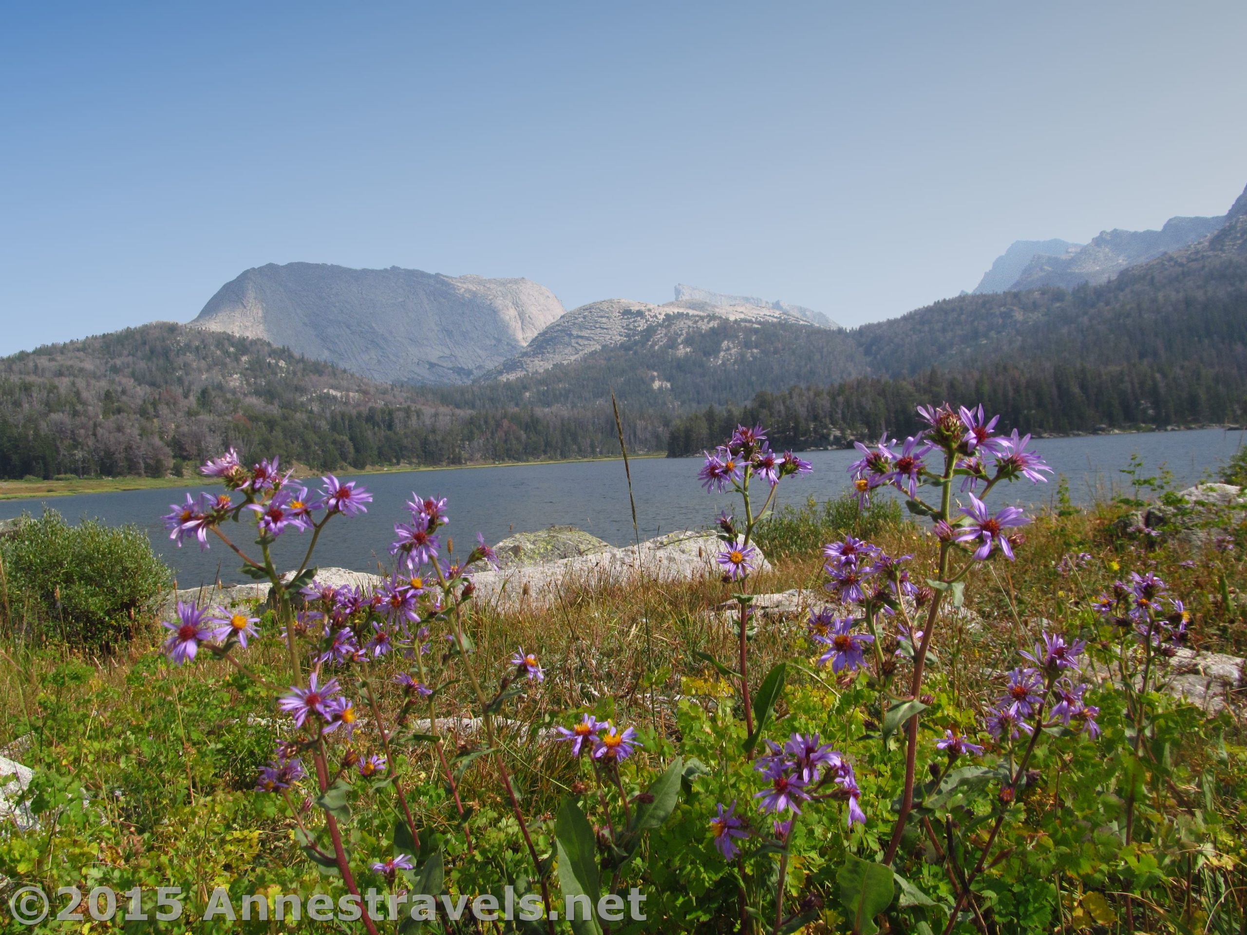
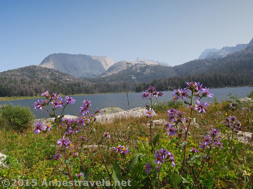
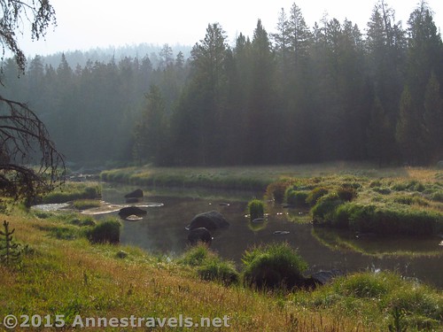
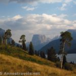
It’s a long trail to Big Sandy Lake. Five whole miles, in fact. But the trail is more or less flat, and it really isn’t that far. (At least in my mind. My feet said otherwise at the end of the hike.) At any rate, the trail itself isn’t that exciting, but the views of Big Sandy Lake are quite impressive and beautiful, especially in the afternoon when it’s not too hazy / smoky.
Quick Stats
(Affiliate links are present on this page.)
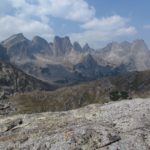
Actually, I went to Big Sandy Lake because I wanted to climb up to Jackass Pass and look over the Cirque of Towers. I’m not much into alpine lakes, unless there’s a nice mountain view to be had, as well. Big Sandy Lake does have quite the view over it of nearby impressively sheer and rocky mountains (classic Wind River scenery), so I’d recommend it as a destination unto itself. Because of the number of pictures (and the sheer beauty of the area), I’ve decided to split the hike into three different posts – this one about Big Sandy Lake and the first part of the hike, the second covering the trail up through Jackass Pass to North Lake (a true gem with the sheer mountain cliffs all around), and the third completing the hike to the end of Jackass Pass where I could look into the Cirque of Towers – one of the most awe-inducing sights in the Wind Rivers, if not in all of western Wyoming. But that’s a total of 17 miles RT, so don’t think that is a quick-and-dirty dayhike. It’s doable as a dayhike (after all, I did it) but it’s also not for the faint of heart. More on that in another post!
The trail to Big Sandy Lake begins at the well-marked, very crowded trailhead. There are many destinations that can be reached from Big Sandy Opening (as the trailhead is called), and numerous options for overnight hiking, so although the parking area is fairly large, it was also filled to near capacity the two days I stayed in the area.
Not far down the trail, stay left, following the sign for Big Sandy Lake. At 0.25 miles, stay right, again following the signs for Big Sandy Lake. The first trail would have taken you to the campground, the second, to the corrals. Between the trailhead and this second trail junction, no horses are allowed.
The wide path continues, quite flat, to mile 0.5, where the Continental Divide Trail heads left up the hillside. Continue straight (again following the sign) and cross Big Sandy River. This shouldn’t be difficult at all, although it might be more challenging during spring runoff.
Less than a quarter mile later, the Continental Divide Trail diverges to the right, heading toward Sedgwick Meadows. Continue straight (left) on the narrowing, exceedingly dusty trail.
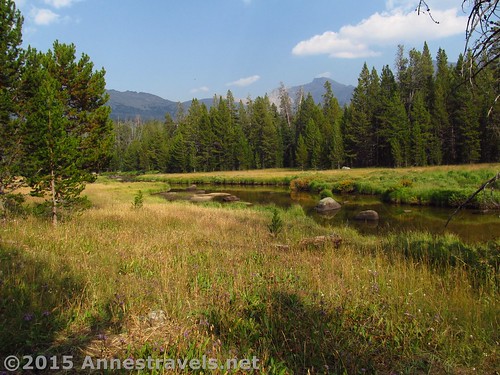
From here, the trail rolls slightly as it more or less follows the Big Sandy River 2.6 miles to the next trail junction, entering the Bridger Wilderness at mile 1.5. Continue straight toward Big Sandy Lake, as the trail to Diamond Lake heads left.
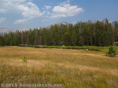
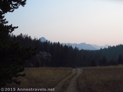
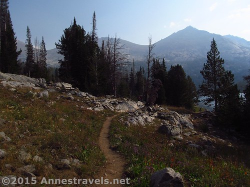
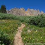
The trail leaves the river at this point and begins to roll in earnest. It also becomes somewhat rockier, although it’s still a not-too-difficult trail, and there’s no hope of getting lost. The worst thing is the dust, mostly kicked up by the horses and mules, as well as hikers’ feet.
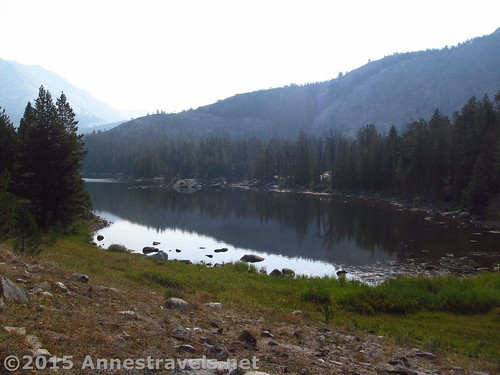
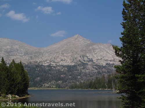
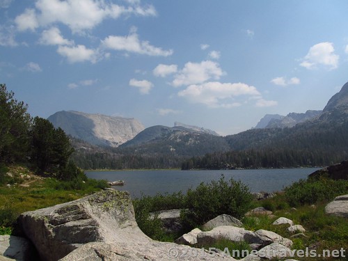
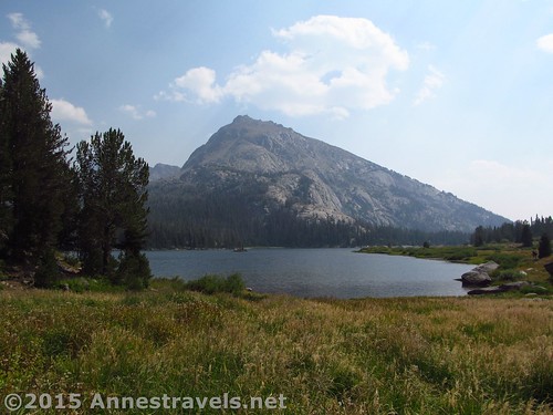
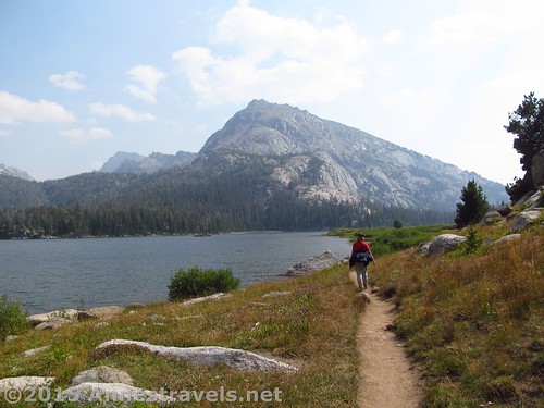
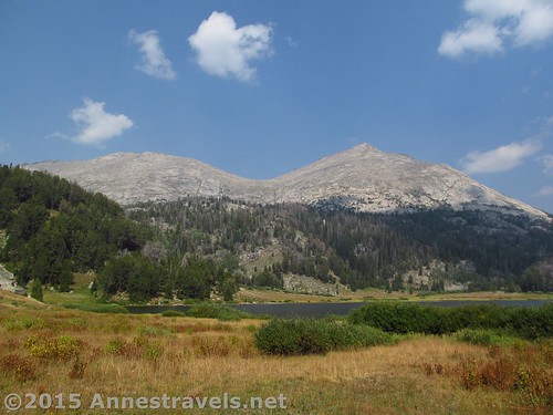
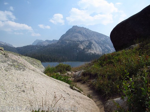
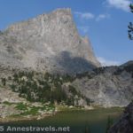
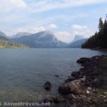
Then, finally, at 5.0 miles, come in sight of Big Sandy Lake and an unmarked trail junction. Turning right takes you along the southern shore of Big Sandy Lake and up toward Clear Lake. Continuing straight / left takes you along the western shore of Big Sandy Lake, with views across the lake toward Schiestler Peak and other sheer-cliffed mountains, to the lake’s nothern end and the beginning of the Jackass Pass Trail (unmarked, but well-trod, for the past several years) that leads to the Cirque of Towers.
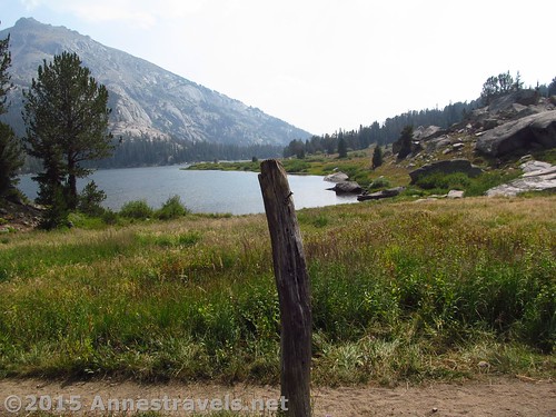
Personally, I like the left trail, with its sweeping vistas of the lake and many large rocks near the trail for enjoying its beauty. Traveling all the way to the northern end (and Jackass Pass Trail) is another 0.75 miles beyond the Clear Lake Trail Junction.
Return the way you came, or accept the allure of going higher into the wilds of the Wind Rivers via the Jackass Pass Trail or hiking the diminishing trail around the northern end of Big Sandy Lake. Either way, you won’t be disappointed.
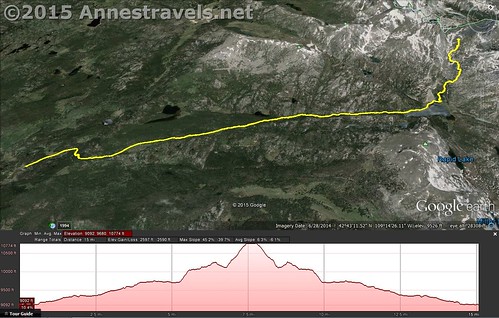
Round Trip Trail Distance: 11.5 miles
Lowest Elevation: 9,095 ft.
Highest Elevation: 9,718 ft.
Net Elevation Gain: 623 ft.
Facilities: Restrooms at the trailhead. No drinking water available at the trailhead – come prepared!
Trail Notes: Normally I’d consider this far too long a hike for “just a lake”. But there are also the views over the lake, which at least make it worth considering (my apologies to all you alpine lake lovers out there!) Big Sandy Lake is the gateway for backpackers entering the wilds of the Wind Rivers. Be ready to share the lake with many weekend backpackers and a good number of dayhikers, as well.
Fees: None
Trail 
![]()
![]()
Road ![]()
![]()
Signs
Scenery ![]()
Would I go 100 miles out of my way for this? ![]()
Overall Rating: ![]()
Key GPS Coordinates
Trail beginning: 42.68840N / -109.27079W (42° 41′ 18.24″ / -109° 16′ 14.844″) (9,099ft.) (0.0)
First trail junction: 42.68941N / -109.27017W (42° 41′ 21.876″ / -109° 16′ 12.6114″) (9,102ft.) (400ft.)
Corrals Junction: 42.69191N / -109.26911W (42° 41′ 30.876″ / -109° 16′ 8.7954″) (9,095ft.) (0.25)
Dad’s Lake / Continental Divide Trail Junction: 42.69560N / -109.26666W (42° 41′ 44.1594″ / -109° 15′ 59.976″) (9,098ft.) (0.5)
Sedgewick Meadows / Continental Divide Trail Junction: 42.69484N / -109.26466W (42° 41′ 41.4234″ / -109° 15′ 52.776″) (9,124ft.) (0.73)
Enter Bridger Wilderness: 42.70207N / -109.25591W (42° 42′ 7.4514″ / -109° 15′ 21.276″) (9,257ft.) (1.5)
Diamond Lake Trail Junction: 42.72275N / -109.23359W (42° 43′ 21.8994″ / -109° 14′ 0.924″) (9,475ft.) (3.4)
Arrive at Big Sandy Lake; stay left: 42.73566N / -109.21216W (42° 44′ 8.376″ / -109° 12′ 43.7754″) (9,718ft.) (5.01)
Trail to Jackass Pass goes Left: 42.74344N / -109.20545W (42° 44′ 36.3834″ / -109° 12′ 19.6194″) (9,714ft.) (5.7)
The gpx file for Big Sandy Lake (plus the route up to the Cirque of Towers Overlook) can be downloaded – please note that this and the GPS Coordinates are for reference only and should not be used as a sole resource when hiking this trail.
Download GPX File size: 399.3 KB Downloaded 832 times
(Note: I do my best to ensure that all downloads, the webpage, etc. are virus-free and accurate; however, I cannot be held responsible for any damage that might result, including but not limited to loss of data, damages to hardware, harm to users, from use of files, information, etc. from this website. Thanks!)
Getting to the Trailhead
From Pinedale, WY, take US-191 South for almost 12 miles to WY-353 E. This is next to the Boulder Store in the “town” of Boulder. Turn left onto WY-353 E and drive 15.5 miles; continue straight on Big Sandy / Elkhorn Road for an additional 11.8 miles. (The road turns to dirt somewhere in this area.) Not long after crossing the river, turn left, following the sign for Big Sandy Opening, onto Lander Cutoff Road. After 7.0 miles, turn left onto Big Sandy Opening Road (again following the signs for Big Sandy Opening). Stay on the main road to the Big Sandy Opening Trailhead a little over 10.5 miles later.
From I-80, take Exit 104 toward Rock Springs. Turn north on US-191 North and drive 38.5 miles. Turn right onto WY-28 E, following the signs for Lander. After 33.3 miles, turn left onto dirt Lander Cutoff Road for 24.8 miles. If ever in doubt about which road to take, stick with the main one; all the major intersections are signed (or at least should be!) Turn right onto Big Sandy Opening Road (signed) and arrive at the trailhead a little more than 10.5 miles later.
From Lander, head south on US-287 S for 9 miles; continue straight onto WY-28 W. After 33.1 miles, turn onto dirt Lander Cutoff Road, and follow the directions above (Rock Springs directions) to Big Sandy Opening Trailhead.
All the roads in this area are dirt. Taking the ones I’ve recommended, the roads are in quite good condition (the Big Sandy Opening Road has some potholes / rocks – and there’s always washboard – but considering the number of low clearance vehicles at the trailhead, it can’t be too bad). However, GPSes don’t necessarily take good roads vs. bad roads into consideration – ours consistently told us to turn on the California Trail, which is just a single track heading out across the scrubland with an occasional fence across it, as well as a number of two-sandy-tracks-in-the-sagebrush roads. Don’t be deceived – stick with the main, well-maintained roads!
Oh, and the views approaching the Wind Rivers from the west are outstanding!
Zoom map out to browse nearby hikes & places of interest
This Week’s Featured Product!
Considered one of the premier, easily available guides for hiking in the Wind River Range, this book covers hikes of various lengths and difficulties. General maps and detailed directions, combined with suggestions for various types of hikers and backcountry enthusiasts, make it a book worth buying if you plan to spend time in the Wind River Range.

7 responses to “Day Hiking Big Sandy Lake in the Wind Rivers”
[…] about 17 miles RT – but it was also so worth every single step! (Especially since we got to see Big Sandy Lake and North Lake on the […]
[…] out of the way, here’s the rest of the story. We began by hiking the five nearly flat miles to Big Sandy Lake, walked the 0.75 miles around the lake, then turned upward into Jackass Pass, arriving at North […]
[…] of elevation gain. This is actually the second post in a series about hiking to Jackass Pass – the first one (to Big Sandy Lake) is here, and I’ll post the third (hiking up to Jackass Pass and the Cirque of Towers Overlook) next […]
[…] near Big Sandy Lake in the Wind Rivers of […]
[…] Big Sandy Lake. This is probably one of the most popular areas of the Wind River Range due to its vicinity to many other more popular destinations, but Big Sandy Lake is also a great destination unto itself. And even though the hike is 11.5 miles RT, the trail is so flat, climbing only 600ft., it feels like much less. […]
[…] Day Hiking Big Sandy Lake in the Wind Rivers. Another great Wind River hike, this one is really more of a great hike because it’s the corridor to some of the most spectacular views of the Winds… the Cirque of Towers Overlook, not to mention Deep Lake (which is on my bucket list for someday!) 11.5 miles RT with 623ft. of elevation gain. […]
[…] over Big Sandy Lake in the Wind River Range of […]