

I just got back from a couple glorious weeks in the state of Wyoming, hiking, seeing new sights, and generally discovering a side of the US I’d never experienced before. When most of us think of Wyoming, we think of an endless, empty sagebrush, or, if we’re familiar with the national parks, the geysers of Yellowstone and perhaps the classic view of the Tetons.
(Affiliate links are present on this page.)
Yet on this trip, I found a part of Wyoming that goes beyond hot springs and historic buildings in the shadow of a jagged mountain range. This Wyoming has intricately eroded badland-like pinnacles, views that seem to roll California, Colorado, and Washington into one, and sheer-faced mountain peaks and canyons with gem-like lakes and unique, flat-topped mountains. This is the part of Wyoming that isn’t necessarily detailed on internet blogs or in the tourist books, but it’s just as worth visiting.
So of course I’ll be detailing my hikes on this blog over the next few months, but just for this week, I thought I’d give a sneak peak of what I’ll be posting about later!
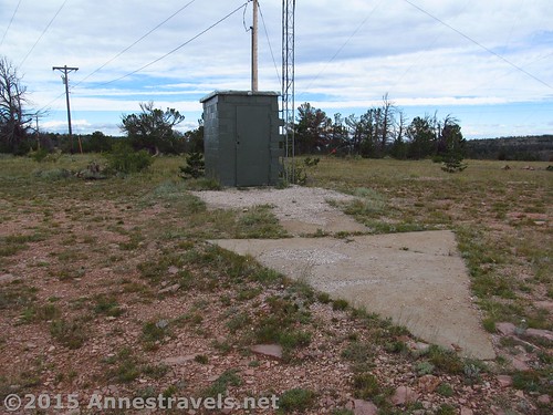
We started out in eastern Wyoming. I’d read about huge concrete arrows made in the early days of aviation to direct pilots across the US, where landmarks could be few and far between. A number of these arrows still exist, including two not far off I-80 in eastern Wyoming.
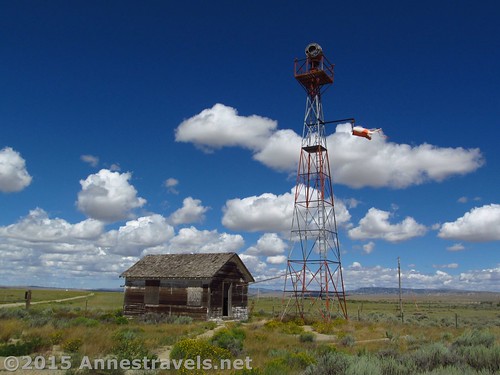
The unique thing about the Medicine Bow Arrow is that it still has the beacon that would be lit for night-flights and the beacon’s generation house (pretty badly vandalized on the inside). Nearby, we stopped for a bit at the Medicine Bow Museum – pretty cool, especially since we got to go inside a real, honest-to-goodness caboose!

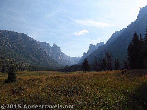
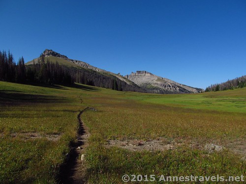
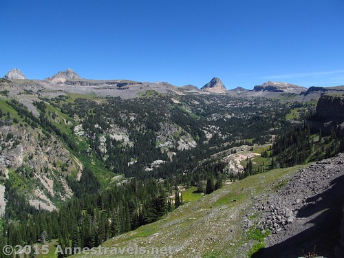
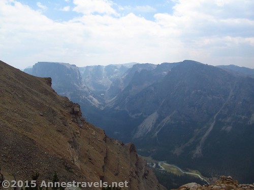
Then it was off to Togwotee Pass in the Absaroka Range (just east of the Tetons) for a couple hikes:
And Bonneville Pass:
While we were at it, we kept walking a short distance (and scrambled a bit further) to see Dundee Falls.
But we all wanted to keep going west to the western side of the Teton Range. We’d hiked Table Mountain once before, and it was so beautiful that we couldn’t wait to get back and see it (and more!) again.
Our first stop was the Darby Canyon Trail. I wanted to go all the way over the Teton Crest Trail, but since there wasn’t a trail (like the map said there should be) and it was a lot longer (than the map said it should be), we only made it up to Fossil Mountain. The views were pretty good, though.

The next day wasn’t nice, so we found a trailhead on the topo map that might be ok. Only problem was, a house had been built in the middle of the road to the trailhead. And a fence had been constructed over the road beyond the house. So that didn’t work out so well, and we ended up at a different trailhead, hiking the Sough Leigh Trail up to a (sort of) view of the Tetons.
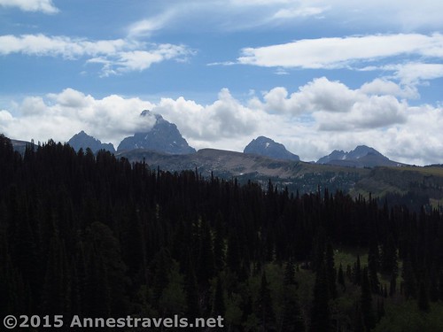
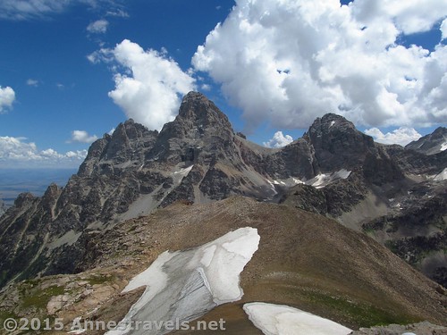
Thankfully, the weather cleared up, and by the next day we were able to do Table Mountain – via the Face Trail! I’ve done Table Mountain before, but the views from Table Mountain are some of the most spectacular I saw on the trip. Truly amazing!
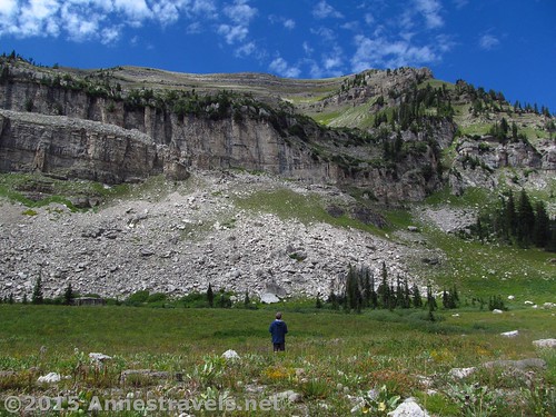
The next day we experienced Wyoming Weather at its finest, or at least most normal. I’d read that it was supposed to be clear (which in case you’re curious means clouds will begin to blow in around noon) until mid-afternoon, then become rainy in the evening. Well, this particular day, as we set out on the Stairway to Heaven Trail, it was lightly misting. Several mornings it had misted as we started, then cleared up, so I wasn’t worried. Until we got to the trail junction a couple miles from the trailhead and it began to thunder and pour! We ended up spending nearly two hours waiting for the rain to stop, then made our way upward through the sopping bushes to the top of the Stairway to Heaven. Only then, as we ate a late lunch, did the sun come out!
So just for fun, we kept walking along the trail that eventually leads to the Teton Crest Trail. And along the way, we found the most spectacular view over the famed Alaska Basin!
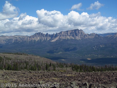
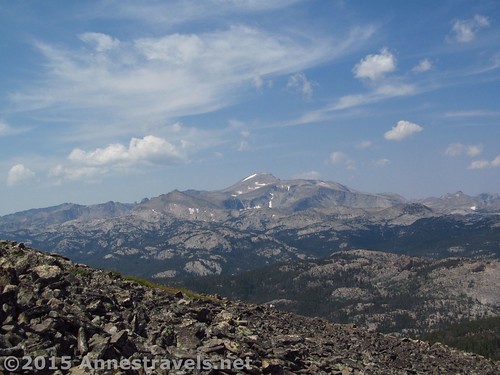
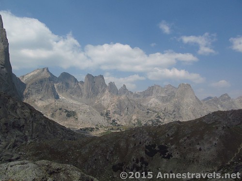
But by this time we’d sort of exhausted what the Tetons had to offer, so off we went to explore the Wind River Range, beginning with Roaring Fork Mountain (via Stough Creek Pass) in the far southern end of the range:
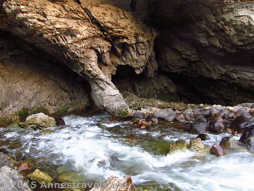
And on the way out, we couldn’t resist stopping for an hour at the free Sinks Canyon State Park, where the Wind River literally disappears into a cave, and comes out of the ground a quarter mile away, yet some two hours later.
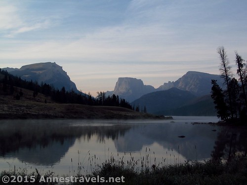
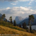
Then we drove all the way around the range up to the Green River Lakes. A more accessible, beautiful area of the Wind Rivers probably doesn’t exist. Even though we arrived late in the day (I don’t necessarily recommend the ways that I drove between areas of the Wind Rivers, but more on that later), we took the evening to walk around Lower Green River Lake (and the second (or first, really) part of that hike is here). (Actually, this picture was taken from the same trail the next morning.)
And the next morning we got up early to hike White Rock via Slide Creek Falls – way too long, with fresh avalanche damage on the Northeast Slopes and a burned out forest on the Northwest Slopes, it ended up being a grueling 15 mile hike, about half of it without a trail. The weather also turned cloudy on us, but I’d do the (easier way route) again in a heartbeat. In fact, I’d go back to that whole area for a few days of hiking – it’s that spectacular!
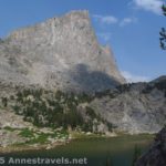
But we were at the end of the trip, and several of us wanted to see the famed Cirque of Towers before heading home. Talk about a long day hike – it turned out to be about 17 miles RT – but it was also so worth every single step! (Especially since we got to see Big Sandy Lake and North Lake on the way!)
What a way to end a trip! (Except that we made a quick stop at the Hobo Pool on the way home!) And be on the lookout: I’ll detail all of these hikes on the blog before too long!
Zoom map in to browse individual hikes
This Week’s Featured Product!
Written by a wilderness ranger, this book takes dayhikers and backpackers into the known and wilderness areas of Wyoming.


5 responses to “Blog Sneak Peak: The Wyoming You Never Knew”
Once upon a time I lived in northern Wyoming. Thought you might enjoy an online map with hi-res topos. The following link is centered on the Table Mountain you hiked.
http://www.mappingsupport.com/p/gmap4.php?ll=43.745638,-110.849703&z=15&t=t4
The map is displayed by Gmap4 which is an enhanced Google map viewer I developed.
Gmap4 default map: http://www.mappingsupport.com/p/gmap4.php
Gmap4 homepage: http://www.mappingsupport.com/p/gmap4.html
Joseph
Redmond, WA
Regarding the concrete arrow, I find that directions often come in handy when exiting the outhouse.
If you ask me, I find that way too many things are named after the Devil. But at least you sometimes get a warning. http://www.pbase.com/greglief/devils_staircase
The Sinks looks interesting. I’ll be driving right past the lesser known Lost Lake in Oregon, but I probably won’t even stop. To be honest, it doesn’t look very scenic unless you’re looking right at the sink hole. And with the weather conditions up there this year there may not even be any water to flow into the hole.
Have you been to Natural Bridge near Crater Lake? The Rogue flows into a lava tube an reemerges a short distance away. It’s interesting to see the amount of water that it turbulently flowing into the portal, but it’s right under your feet from the official view. It’s much more interesting from the other side of the river, and since that isn’t a trail, there’s no fence to keep people from walking out on the bridge.
Hi Robert, I also don’t get why so many things are “devil this” or “devil’s that”. Why do we have to focus on the dark when so much light exists, especially in the wilderness? If I was naming features, I’d probably use some unpronounceable name like “tubalooloogaba ridge” or something that really described the area like “Rock Formation City”.
Hadn’t heard about Lost Lake yet. I’d have driven right by The Sinks – we’d seen it in 2003 and I’d been somewhere between unimpressed and terrified the entire time one of the kids was going to fall into the river – but the driver pulled into the parking lot and I thought, “Hey, what a good blog post”… Ah, the things we bloggers think…!
Oh, and about the natural bridge…haven’t seen it yet. I think I’d be a bit worried walking out on the lava tube with a river flowing through it 🙂
Joseph, pretty cool topos. I’ll have to check them out for other areas, too.
-Anne