

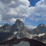
Table Mountain, on the “non-tourist” west side of Grand Teton National Park, has got to be one of our favorite views ever – and I mean that seriously. If you interviewed everyone in the group, they’d probably list that single view as one of the best we’ve ever done. And considering we’ve visited 48 states and a number of Canadian provinces (not to mention a bit of non-North American travel), that’s saying something!
Quick Stats
(Affiliate links are present on this page.)
Why does the view from Table Mountain trump so many other views we’ve seen? Well, part of it is variety – you’ve got everything from craggy cliffs to striking mountains (not quite snow-capped peaks, but close), Colorado-Rockies-type scenery to lovely green canyons, rock slides with lakes at the bottom to almost Flat Tops-type meadows, mountain upon mountain and the yellow plains of Idaho. Really, I think it’s the variety that appeals to us so much – not only when you get tired of one view can you find another, equally striking view, but there’s just about everyone’s favorite types of views here – in one place!
There are two trails to the top of Table Mountain. One – the Huckleberry Trail – is 11 miles RT. I don’t personally recommend this trail because it’s longer and quite steep. However, if you really hate steep trails (like, really, really steep trails) you might want to take it, because the alternative is the Face Trail. Now, I like the Face Trail. There’s no bones about it; it’s straight up, and straight down, without pretense, and 9.2 miles RT. But we’re talking so steep it can be hard to keep your footing coming down.
The first time we hiked Table Mountain, we went up the Face Trail and down the Huckleberry Trail, for a supposedly 10.2 mile hike (it certainly felt longer than that – I’d have said it was closer to 12 miles RT!). Many people still do the loop. But we decided to try going up and down the Face Trail on our second visit, since from our memory the Huckleberry Trail wasn’t that much less steep and was still so much longer. I definitely recommend both directions on the Face Trail if you’re sure-footed, but I “spotted” at least one member of my group the whole way down after the treeline because I didn’t want her to slip and get hurt (and I did end up catching/stabilizing her a couple times, so I’m glad I was there).
So the conclusion: The Face Trail is great if you’re sure-footed; if not, go down the Huckleberry Trail.
We started out early on an August morning. We were by no means the first people on the trail – in the four years since we last hiked the trail, it’s gone from being a local secret to a teeming trailhead of people from all the states and even foreign countries. (Seriously – one of my group members talked with a group from Germany who – he surmised – had read my previous blog post about the Face Trail and was going for it!) Come early for a parking space on summer weekends.
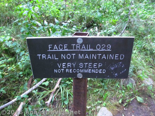
The trail begins behind the restrooms at the end of the road. Don’t get confused with the trail to Alaska Basin – it’s well marked, wide, and has a big sign pointing the way, while the Face Trail is nearly unmarked. Still, it’s pretty obvious and is becoming more so due to heavy use.
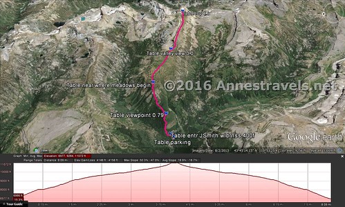
The trail heads upward steeply from the first through bushes. As it climbs, it enters aspens and, at 0.8 miles comes to a small viewpoint. I highly recommend the view; it’s just a canyon, but is quite striking in the early morning sunlight.
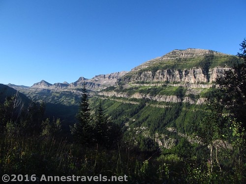
After this, the trail really begins to climb in earnest. Like, more than 45 degree angle steepness. Sometimes it feels like you’re going nearly straight up (though you aren’t). Thankfully, there are enough trees and roots to make hiking possible, even an enjoyable challenge. There are a few places where the trail passes through stands of aspen on a more level trail – so you’re not going up all the time.
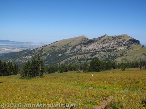
At mile 2.0, and 2,308ft. above the trailhead, the trail leaves the aspens behind and enters meadows. Rejoice, the worst of the steepness is over!
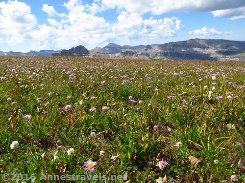
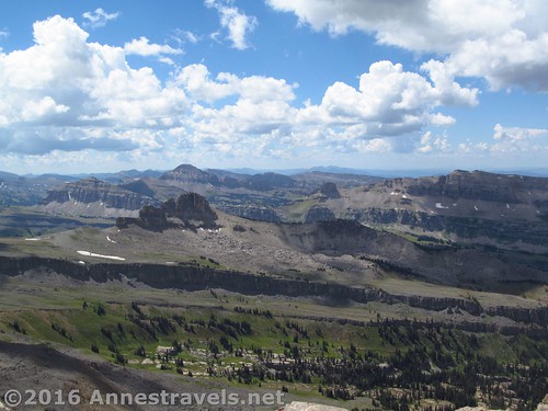
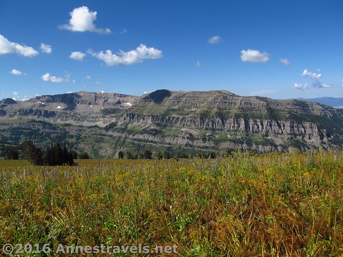
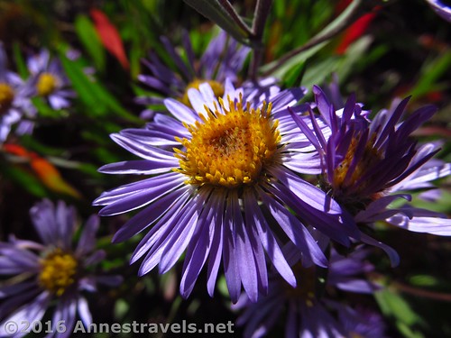
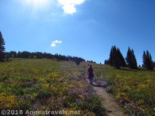
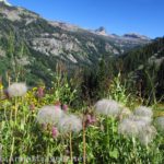
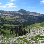
Continue to follow the trail upward through ever-increasing meadows and occasional stands of trees. The time of year you hike will depend on exactly where the wildflowers begin – very early in the season, wildflowers will be here, while later, the wildflowers will begin higher up on the trail. Views also begin to improve in this section – of low Teton mountains on either side and of the yellow plains of Idaho far below (one group member thinks these views over the plains are one of the best parts of the hike, but I’m not so sure, lol).
A mile after entering the meadows, the trail will arrive at a trail junction (likely unmarked, though you never know what sign may magically appear). Turn right to continue uphill – turning left will take you down and back to the parking lot via the Huckleberry Trail).
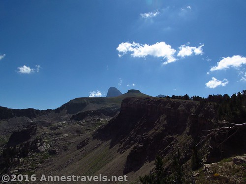
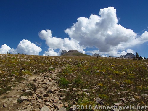
After the trail junction, the trail becomes somewhat rockier and passes through fewer stands of trees – you’ve effectively hit the treeline and are in a world of meadows, rocks, and wildflowers. I’d call this simply lovely. Ahead is the massive bulk of Table Mountain (don’t worry; it’s easier to climb than it looks from here), on either side are low Teton mountains, and behind are the plains of Idaho. Truly beautiful!
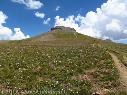
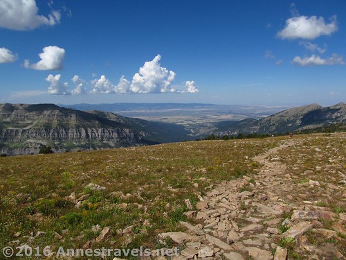
Keep climbing, higher and higher through the meadows. The trail isn’t so very steep now, just relentless. About a mile beyond the trail junction, the trail will begin to climb the summit block. This is more difficult – you’ll have to scramble a bit, but it’s not bad. At 4.6 miles from the trailhead, arrive at the top of Table Mountain.
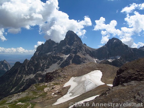
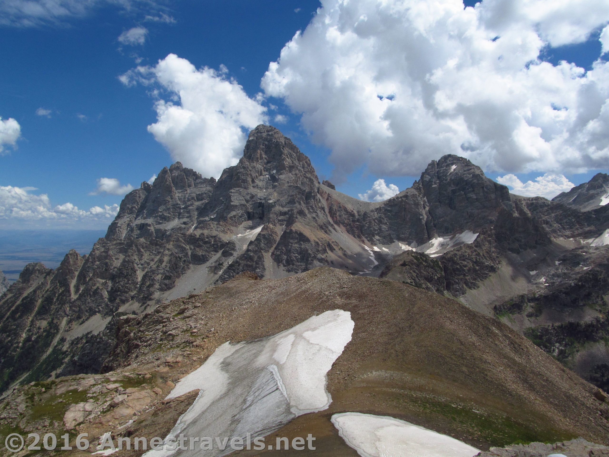
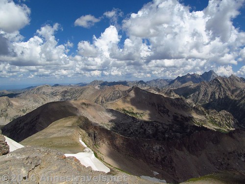
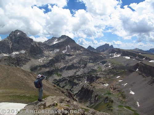
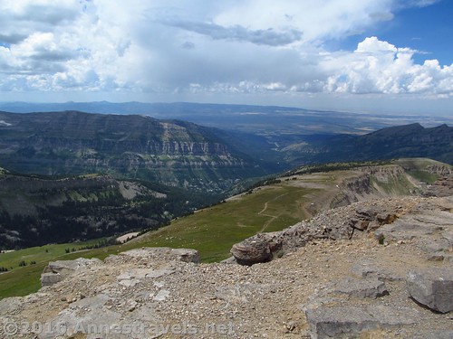
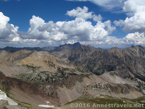
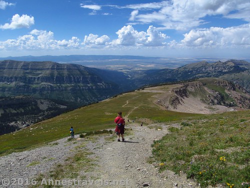
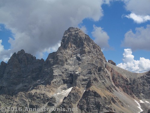
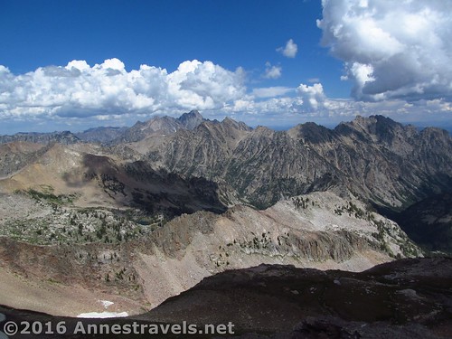
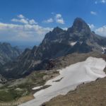
Now, stop and take in the view. Wow! It’s Amazing with a capital A! Ahead are the Tetons – it’s not hard to figure out which is Grand Teton, Middle Teton, and South Teton. To the left of the Tetons is Cascade Canyon – totally cool! Beyond Cascade Canyon and to the other side of the Tetons are peak upon peak and canyon upon canyon, almost like you’d see in Colorado. Oh, my! And opposite the Tetons you can see out onto the plains of Idaho. Incredible!
Soak up the view for a bit before heading back down… you’ve worked hard and the view is worth a few minutes of staring with you jaw on the ground!
Round Trip Trail Length: 9.2 if you go up and down the Face Trail
Lowest Elevation (Trailhead): 6,963ft.
Highest Elevation (Table Mountain): 11,065ft.
Net Elevation Change: 4,102ft.
Facilities: Primitive restroom and water at the trailhead; campground nearby; free-range camping further up the road
Fees: None
Trail Notes: Well, I’ve already said that it’s steep, so I won’t say it again. Also, expect to share this trail with quite a number of boy scouts – apparently the troops in Utah (and maybe Idaho) like to come out here.
Trail 
![]()
![]()
![]()
Road ![]()
![]()
Signs ![]()
![]()
![]()
Scenery
Would I go 100 miles out of my way for this?
Overall Rating: 
![]()
Key GPS Coordinates
Parking: 43.75578N / -110.91542W (43° 45′ 20.808″ / -110° 54′ 55.5114″) (6,907ft.)
Trail Beginning: 43.75595N / -110.91513W (43° 45′ 21.4194″ / -110° 54′ 54.468″) (6,963ft.) (0.0; ended at 9.4)
Enter Jedediah Smith Wilderness: 43.75647N / -110.91422W (43° 45′ 23.292″ / -110° 54′ 51.192″) (7,075ft.) (400ft.)
Viewpoint: 43.75723N / -110.90690W (43° 45′ 26.0274″ / -110° 54′ 24.8394″) (8,029ft.) (0.79)
Begin Meadows: 43.76006N / -110.89342W (43° 45′ 36.216″ / -110° 53′ 36.312″) (9,271ft.) (7.4 on the way back)
Huckleberry / Face Trails Junction (turn right to top): 43.75304N / -110.87604W (43° 45′ 10.9434″ / -110° 52′ 33.744″) (9,881ft.) (3.0)
Valley View: 43.75314N / -110.87581W (43° 45′ 11.304″ / -110° 52′ 32.916″) (9,895ft.) (3.0)
Top: 43.74675N / -110.85184W (43° 44′ 48.2994″ / -110° 51′ 6.6234″) (11,065ft.) (4.6)
The gpx file for the Face Trail up Table Mountain can be downloaded – please note that this and the GPS Coordinates are for reference only and should not be used as a sole resource when hiking this trail.
Download File size: 270.6 KB Downloaded 788 times
(Note: I do my best to ensure that all downloads, the webpage, etc. are virus-free and accurate; however, I cannot be held responsible for any damage that might result, including but not limited to loss of data, damages to hardware, harm to users, from use of files, information, etc. from this website. Thanks!)
Getting to the Table Mountain Trailhead
From the town of Driggs, Idaho (along Rt. 33), turn east at the stoplight onto East Ski Hill Road (also known as East Little Avenue). This is a left turn if you’re coming from the north (Yellowstone, etc.), a right turn if you’re coming from the south (Jackson Hole). Key Bank and Southby’s will be on the corners of this turn. Drive 6.6 miles, then turn right on Teton Canyon Road. Drive on this road for 4.5 miles — the road is quite passible by passenger cars (I saw a smart car do it), but it has quite a bit of washboard, so we couldn’t get over about 20 mph. You’ll pass a couple of campgrounds and a Boy Scout Camp before you reach the end of the road. This parking area – at the very end of the road – has a large sign by a wide trail stating that it is the Alaska Basin Trail. You’ve arrived! (Note: Although it’s not marked as such, this is the same trailhead for Table Mountain and the Face Trail – the Huckleberry Trail (their idea of the Table Mountain Trail) begins about a tenth of a mile back up the road near the campground.)
Zoom map out to browse nearby hikes & places of interest
This Week’s Featured Product!
Very few books touch on the Jedidiah Smith Wilderness (where Table Mountain is located) or other trails on the western side of the Tetons. This book does offer some other choices in the same area as this hike, as well as across the state of Wyoming.


14 responses to “Table Mountain – Up and Down the Face Trail”
[…] I found this trail quite a bit less demanding than most other hikes I did in Wyoming, including Table Mountain and the Alaska Basin Overlook in the Tetons and some of the trails surrounding the Green River […]
[…] it is the Alaska Basin Trail. You’ve arrived! (Note: this is the same trailhead as for the Face Trail up Table Mountain, so expect the parking area to be crowded in the […]
[…] Those were just a few of the comments from group members when we climbed Table Mountain on the edge of Grand Teton National Park. It was amazingly spectacular; one of the very best views of the Teton Range I’ve seen anywhere. You’re on the back (west) side, so you don’t get the classic Teton views, but the spectacular-ness well and makes up for this. There’s only a valley between you and the Tetons, so it’s even up close and personal. In this post, I’ll talk about the Face Trail, which we ascended to the mountain, and in the next post, I’ll talk about the Huckleberry Trail, which we descended. Both trails get you to the top of the mountain; the Face Trail is very steep and shorter, while the Huckleberry Trail is much longer and moderately less steep. So, you can take your pick which you want to do. (You can read about my trip up and down the Face Trail here.) […]
[…] In the last post, I talked about taking the Face Trail up to Table Mountain, right on the edge of Grand Teton National Park. The views from the top are beautiful; some of the best views of the Tetons I’ve ever seen. However, there are two trails to the top—one that’s 7 miles round trip (the Face Trail) and steeper, and other that’s 11 miles round trip (the Huckleberry Trail) and only slightly less steep. We took the Face Trail up and the Huckleberry Trail down (a popular way to do the hike), but I’m not sure I’d do it that way again: the Huckleberry Trail is still very steep, so I don’t personally think the extra 2 miles are worth it. However, I’ll write about it, first telling you how to get to the trailhead, then taking you down the trail from Table Mountain like I did it. (Update: A few years later, I did take the Face Trail up and down; you can read about that here.) […]
[…] Table Mountain via the Face Trail, Grand Teton National Park, Wyoming […]
[…] The best hike to these views is the Table Mountain Trail (although I personally recommend the Face Trail over the Huckleberry Trail) to see the west side of Grand Teton in all its rugged splendor. And […]
[…] to some views over the Teton Crest Trail. I won’t say it was anywhere near as spectacular as Table Mountain, but it was certainly a nice view and a great […]
[…] I found this trail quite a bit less demanding than most other hikes I did in Wyoming, including Table Mountain and the Alaska Basin Overlook in the Tetons and some of the trails surrounding the Green River […]
[…] Teton National Park is spectacular. I mean, really, really spectacular. Other hikes (such as Table Mountain) are beautiful, but they don’t have the jaw-dropping splendor of Garnet Canyon. As you’re […]
[…] of the parking area, just to the right of the sign kiosk – you can’t miss the trail, unlike the Face Trail up Table Mountain, which does its best to hide beyond the […]
[…] the weather cleared up, and by the next day we were able to do Table Mountain – via the Face Trail! I’ve done Table Mountain before, but the views from Table Mountain are some of the most […]
[…] Although most hikes into the Jedidiah Smith Wilderness are long by dayhike standards (trails up Table Mountain, the Stairway to Heaven, and Alaska Basin Overlook are examples), there is at least one short hike […]
[…] Top 15 Pages on Anne’s Travels in 2016! (Picture from Table Mountain, Wyoming, one of the most socially active posts this past […]
[…] Mountain (Face Trail or Huckleberry Trail) (9.2-11.3 miles RT). If there’s one trail on the western […]