

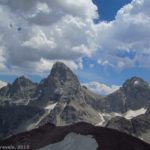
Grand Teton and Cascade Canyon from Table Mountain
“Well, I’ll give this an ‘A’ for Spectacular.”
“It’s amazing to me that anything could be quite this beautiful.”
“This has got to be the best view of the Tetons I’ve ever seen.”
“How could anything be this pretty?”
“I don’t know why anyone in the world wouldn’t want to be here…it’s so pretty!”
Those were just a few of the comments from group members when we climbed Table Mountain on the edge of Grand Teton National Park. It was amazingly spectacular; one of the very best views of the Teton Range I’ve seen anywhere. You’re on the back (west) side, so you don’t get the classic Teton views, but the spectacular-ness well and makes up for this. There’s only a valley between you and the Tetons, so it’s even up close and personal. In this post, I’ll talk about the Face Trail, which we ascended to the mountain, and in the next post, I’ll talk about the Huckleberry Trail, which we descended. Both trails get you to the top of the mountain; the Face Trail is very steep and shorter, while the Huckleberry Trail is much longer and moderately less steep. So, you can take your pick which you want to do. (You can read about my trip up and down the Face Trail here.)

The “welcoming” sign a few feet up the trail
The Face Trail and Huckleberry Trail have two separate parking areas, about 1/10 of a mile(0.2 km) apart. To get to them, from the town of Driggs, Idaho (Rt. 33), turn east at the stoplight onto East Ski Hill Road (also known as East Little Avenue). This is a left turn if you’re coming from the north (Yellowstone, etc.), a right turn if you’re coming from the south (Jackson Hole). Key Bank and Southby’s will be on the corners of this turn. Drive 6.6 miles (10.6 km), then turn right on Teton Canyon Road. Drive on this road for 4.5 miles (7.2 km)—the road is quite passible by passenger cars (I saw a smart car do it), but it has quite a bit of washboard, so we couldn’t get over about 20 mph (32 kph). You’ll pass a couple of campgrounds and a Boy Scout camp before you reach the parking area for the Huckleberry Trail. There is another campground right across the parking area if you want to stay in it ($10/night; there are also multiple “backcountry” camping pull-offs along the road if you prefer solitude). If you want to hike the Face Trail, drive to the end of the road, 0.1 miles (o.2 km) further. Both parking areas have primitive restrooms, water, and a garbage canister.

The cliffs across the valley, as seen about the time the trail flattens out
The Face trail is not easy to find. It is not marked, and the Forest Service would be just as happy if it was never used. To find the trail, ignore the large, wide path next to the sign that points towards Alaska Basin. Instead, go over to the primitive restrooms. Just to the left of these there is a well-defined (though narrow) trail that heads up into the woods. Follow this trail. After a few yards, you’ll come to a sign that reads, “Face Trail 209. Trail Not Maintained. Very Steep—Not Recommended.” Well, they’re right that the trail is steep. It’s actually quite well maintained, and you’ll have to decide for yourself whether or not you’ll recommend it. I do, especially for going up. In fact, I highly recommend that you take this steeper trail, since it’s two miles (four km) shorter than the Huckleberry Trail, and not really that much steeper.

View from the Face Trail
The trail begins to climb immediately. The first mile (2 km) is the worst; you’ll be scrambling upward on a trail that is dirt and loose rocks and gravel. It’s very doable; even the members of my group who say they aren’t good with such trails didn’t have much trouble. However, it’s also very steep, so we had to stop often to catch our breath. The good thing is that you get peek-a-boo views through the trees of the cliffs across the valley. Especially in the morning, these rocks are lit up brilliantly in the early morning sunshine. Also early in the morning, the trail is in shade, so I recommend that you get an early start. This will also keep you off the mountain top if (when) afternoon thunderstorms roll in.

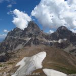
Heading towards the summit block…don’t worry, it’s not as bad as it looks!
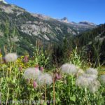
After about a mile (2 km), you will suddenly leave the forest and enter a forested meadow. Right at this change, there is an overlook over on your right off of the trail. I really enjoyed this viewpoint; it’s really pretty, especially in the morning sun. Return to the trail, and keep hiking. For a short while, the trail is almost flat, then it begins to ascend again. The trail continues upward for another 1.25 miles (2 km), gradually passing through forested meadows, meadows with stands of trees, and then mostly meadows with a few trees in them. These meadows were filled with flowers in late July, when I visited. The flowers were the “icing on the cake” and made the scenery even more enjoyable. And oh, the scenery! As you pass through the meadows you get awesome views of cliffs, mountains, valleys, meadows, streams; it’s all so beautiful! It just gets better and better the higher you climb.

Flowers near the summit block
At 2.25 miles (3.6 km) from the trailhead, you’ll intersect the Huckleberry Trail. Turn right here; there’s only one real trail to the summit block of Table Mountain. Actually, if you’re looking for another nice view, go straight a few feet to a cliff edge instead of turning onto the Huckleberry Trail. The view from here is very nice. Then return to the Huckleberry Trail and continue ascending. The trail may not be as steep as most of the Face Trail, but it’s far from flat. For a while, you’ll be walking up through meadows full of short flowers. Then the trail gets steeper and has more rocks. You’ll cross one large rock-field with cairns marking the trail, and then you’re really on the tundra. Your destination is the impossible-looking mountain in front of you—don’t worry; it’s more doable than it looks from here!

Afternoon clouds
Keep following the trail as it steeply climbs up, up, up over the tundra. Almost 3.5 miles (5.6 km) from the parking area (1.25 miles (2 km) since you joined the Huckleberry Trail), you’ll suddenly turn a gravelly corner and find yourself facing the summit block itself. From here, it’s a short scramble to the top. All along this section of trail, the views have gotten better with each step. However, don’t stop now! You haven’t seen the very best views—the ones of the Tetons—yet. There are several social trails that are all viable ways to reach the summit. Choose the one that looks best to you, and scramble up. And then, stand up and look around!

A view from the top
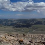
The view spreads out in all directions around you. In front of you are the Teton Mountains; both Grand Teton and Middle Teton seem only a stone’s throw away. To the left of Grand Teton is Cascade Canyon; this was interesting to us because we’d hiked it a few years earlier. Behind you are the plains and farmland of Idaho. Between these two views, on your right and left, are numerous mountains, valleys, basins, canyons, and peaks, some green and some snow-covered. Beautiful! I’ve included a video of the area.

Cascade Canyon
Although it’s called “Table Mountain”, the top is actually quite small. Still, you get different views by going to different ends of the mountain. We went to the end closest to the Tetons and enjoyed a hearty lunch before heading back down. By that time, there were quite a few clouds (though no thunder showers, yet). This made for some very unique pictures.
Return by the way you came, or, at the split, continue straight down the Huckleberry Trail. The later way is a fair amount longer (2 miles; 3.2 km), but it’s also less steep (supposedly…I didn’t find this to be entirely true). I’ll discuss the pros and cons of the Huckleberry Trail in the next post!
Round Trip Trail Length: 7 miles (11.3 km) if you take the Face Trail up and down; 9 miles (14.5 km) if you do the Face Trail/Huckleberry Trail loop
Facilities: Primitive restrooms and water at the trailheads
Fees: None to park; campground at the Huckleberry Trailhead is $10/night. There is a horse campground slightly down the road (towards Driggs). Horses are allowed on both the Face Trail and the Huckleberry Trail (bicycles and motorized vehicles are not). In fact, a trail goes right to the Horse Camp from the Huckleberry Trail.
Trail 
![]()
![]()
![]()
Road ![]()
Signs ![]()
![]()
![]()
Scenery
Would I go 100 miles out of my way for this?
Overall Rating: 
![]()
This Week’s Featured Product!
There’s so much to see in Grand Teton National Park, even on the west side of the mountains! In this book I take you to lesser-known as well as famous trails in the park and also in the rest of the state of Wyoming.


Thank you so much for bringing this to our minds eye. This is a good artile post with a lot of information, great content!
Very interesting post you made here. I enjoyed it.
I’m amazed by the knowledge in this blog I found it to be not only very fascinating but it also made me reflect. It is hard now to locate relevant information to ones search, so I am happy that I found this article post
Pingback: Mammoth Hot Springs: Should I Go?
Pingback: Anne's Travels » 10 Reasons I Choose Dayhiking over Backpacking
Pingback: Blog Sneak Peak: The Wyoming You Never Knew
Pingback: Alternate Views of Famous American Wilderness Areas
Pingback: Day Hiking the Alaska Basin Overlook - Anne's Travels
Pingback: Stairway to Heaven - Views and Wildflowers Galore - Anne's Travels
Pingback: Day Hiking Stough Creek Pass - Anne's Travels
Pingback: Atop Roaring Fork Mountain - Anne's Travels
Pingback: The Pass & Views above Upper Darby Canyon - Anne's Travels
Pingback: Table Mountain – Up and Down the Face Trail - Anne's Travels
Pingback: Table Mountain, Grand Teton National Park, via the Huckleberry Trail
Pingback: Celebrating 20 Years of Family Vacation - Anne's Travels
Pingback: The 12 Most Popular Pictures on Anne's Travels