

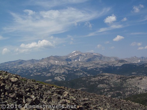
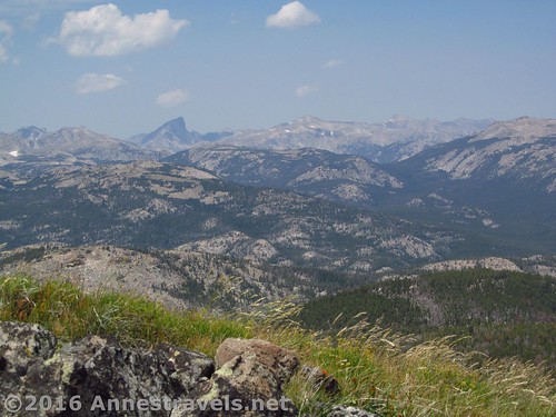
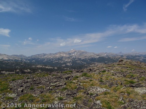
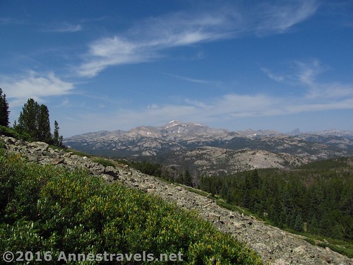
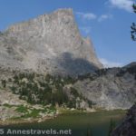
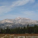
Roaring Fork Mountain in the southern Wind River Range of Wyoming absolutely deserves its name: the ginormous mountain has many arms (or “forks”) and the wind roars over the top at speeds enough to nearly blow me off my feet. Still, the view makes the hike (and wind) worthwhile: Wind River Peak stands clear and tall above the others, while numerous other smaller peaks and cliffs ring the edges of the Stough Creek Basin. At nearly 11 miles RT, it’s a long trek, but it’s nowhere near as hard as many other 11 miles hikes in Wyoming, so I’ll highly recommend it. And did I mention before that the views are spectacular?
Quick Stats
(Affiliate links are present on this page.)
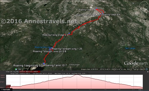
The first 4.6 miles of the hike follow the Stough Creek Basin Trail to Stough Creek Pass. The view from the pass really is awesome. But I wanted to go further – to the top of Roaring Fork Mountain. And what’s a little scree among friends?
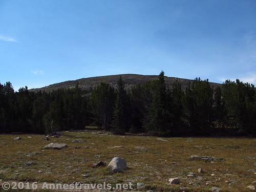
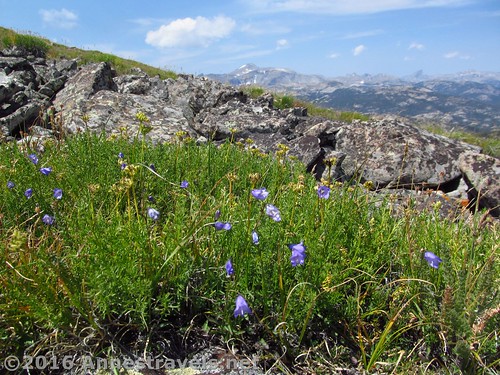
So, following the directions I’d found on the internet (which you can read here – I highly recommend this site for hikes through the Wind River Range), we headed up the left side of the pass. Per the directions, we headed sort of down through the trees, then up, skirting the scree fields. I finally spotted a deer trail through the bushes, and struck up it. The trail is very much there, although the bushes scratched my legs (where are those pants when you need them?). It led uphill, finally ending in a mountain meadow.
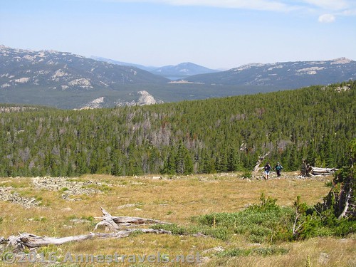
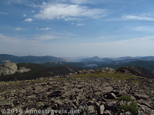
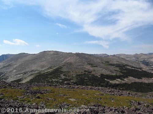
I highly recommend going this far, even if you don’t want a long and involved hike. The view goes from just spectacular views of Wind River Peak to a wide, sweeping view all around the cliffs and peaks above the Stough Creek Basin and beyond. Wow! Totally awe-inspiring!
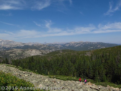
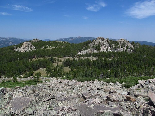
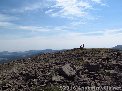
But I wanted to go to one of Roaring Fork’s many peaks. So most of us continued upward toward the nearest of the peaks. We followed meadows for a while, then took to the rocky scree. It’s quite stable, so no more than what I’d consider a Class 2 scramble (a scramble which doesn’t require your hands – I stayed upright 99% of the time).
The higher we climbed, the more the wind roared. What had been a nice gale in Stough Creek Pass was now becoming a regular hurricane. At times I was being blown around the mountain, having to choose my footing carefully and moving my weight cautiously so as to not find myself blown away.
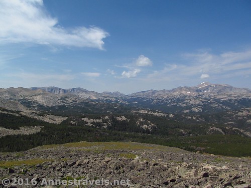
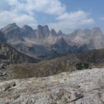
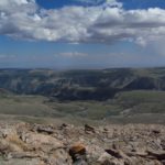
But we did make it to the top, wind and all, hurray! And the views! Oh my! Spectacular! Jaw-dropping! Incredible! Amazing! …but I should really let the pictures speak for themselves, as poor as they are at really conveying the true splendor of the view.
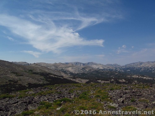
I’d have liked to continue along the top of the mountain to another peak or two (it looks like it would just be more meadows and scree-hopping), but it was already going to be an almost 11 mile hike, and with the length of the other hikes we’d been doing, it seemed like a good idea to call this one a day. Oh well, maybe another time 🙂
Coming down, we simply took to the scree and headed for the pass. This would be doable for climbing up, too, although the meadows make for easier walking.
Overall? Just do it! You’ll be happy you did 🙂
Round Trip Length: 10.6 miles
Lowest Elevation (trailhead): 8,822 ft.
Highest Elevation (pass): 10,954 ft.
Net Elevation Change: 2,132 ft.
Facilities: Horse corral / hitching post and restroom at trailhead; water available in the picnic area, a short distance up the road. A campground is also located nearby.
Fees: None
Trail Notes: I found this trail quite a bit less demanding than most other hikes I did in Wyoming, including Table Mountain and the Alaska Basin Overlook in the Tetons and some of the trails surrounding the Green River Lakes and Cirque of Towers (but maybe length had something to do with the difficulty of the latter two?) Beyond the pass, the trail (or lack thereof) makes it more difficult, but it’s still easier than the Cirque of Towers Overlook.
Trail 
![]()
![]()
Road ![]()
![]()
Signs ![]()
![]()
![]()
Scenery
Would I go 100 miles out of my way for this?
Overall Rating: 
![]()
Key GPS Coordinates for Roaring Fork Mountain
Trail Beginning: 42.69980N / -108.93205W (42° 41′ 59.28″ / -108° 55′ 55.38″) (8,822ft.) (0.0 – ended 10.4)
Enter Popo Agie Wilderness: 42.69980N / -108.93205W (42° 41′ 59.28″ / -108° 55′ 55.38″) (9,001ft.) (0.77)
Turn Right toward stream crossing: 42.69423N / -108.93934W (42° 41′ 39.2274″ / -108° 56′ 21.624″) (9,002ft.) (0.8)
Sream Crossing: 42.69413N / -108.94070W (42° 41′ 38.868″ / -108° 56′ 26.52″) (9,054ft.) (0.9)
Long Bridge: 42.69101N / -108.95544W (42° 41′ 27.6354″ / -108° 57′ 19.5834″) (9,422ft.) (2.1)
Stough Pass: 42.68982N / -108.98559W (42° 41′ 23.3514″ / -108° 59′ 8.124″) (10,540ft.) (4.6)
Roaring Fork First Peak: 42.68489N / -108.98479W (42° 41′ 5.604″ / -108° 59′ 5.244″) (10,954ft.) (5.3)
The gpx file for Stough Creek Pass and Roaring Fork Mountain can be downloaded – please note that this and the GPS Coordinates are for reference only and should not be used as a sole resource when hiking this trail.
Download GPX File size: 302.8 KB Downloaded 701 times
(Note: I do my best to ensure that all downloads, the webpage, etc. are virus-free and accurate; however, I cannot be held responsible for any damage that might result, including but not limited to loss of data, damages to hardware, harm to users, from use of files, information, etc. from this website. Thanks!)
Getting to the Roaring Fork Mountain Trailhead
From Lander, WY, head south on WY-131 for about 9 or 10 miles (follow the signs for Sinks Canyon State Park – you’ll drive right through the park on your way to the trailhead). Continue straight onto Louis Lake Road for an additional 7.2 miles. About the time the pavement ends, turn right onto Forest Road 302 and drive 2 miles to the Worthen Meadow Reservoir. Continue about another 0.5 miles to the end of the road and the trailhead. The trail itself begins near the sign just about where the road meets the parking lot and is signed for Stough Creek Basin (don’t confuse this one with the other trail(s) that leave the parking area near the restroom). It is possible to come up Louis Lake Road beginning just east of South Pass City, but I don’t recommend this route (very dusty, bumpy, and twisting – honest, it’s faster to go through Lander).
Zoom map out to browse nearby hikes & places of interest
This Week’s Featured Product!
If a map would be helpful in hiking this trail – and others in the southern Wind River Range – this is the premier map to get. With a waterproof coating, the map shows trails, features, and so much more.

5 responses to “Atop Roaring Fork Mountain”
[…] what the Tetons had to offer, so off we went to explore the Wind River Range, beginning with Roaring Fork Mountain (via Stough Creek Pass) in the far southern end of the […]
[…] forward to August 2015, and we were driving toward Lander after hiking Roaring Fork Mountain. In the very early morning sunlight, we saw the signs for the state park – visiting was going […]
[…] Roaring Fork Mountain, Wind River Range, Wyoming […]
[…] Roaring Fork Mountain. Get to Stough Creek Pass, then strike off-trail up the mountainside to ever more epic views… and maybe every more epic wind speeds, if bloggers’ experiences are anything to go on. At any rate, the view makes it more than worth the 10.6 miles RT. […]
[…] be (what I’d consider) one of the easier trails to dayhike in the Wind Rivers, and you can always scramble up Roaring Fork Mountain if you want to extend the trail a bit (and improve the view). As it is, it’s 9.1 miles RT to […]