

I’d read on SummitPost.com about White Rock high above the Green River Lakes in the Wind Rivers of Wyoming. Ever since seeing the pictures from the top, I knew I wanted to do that specific hike. It sounded easy enough, even if there wasn’t technically a trail to the top: take the Slide Lake Trail up to the meadows, then bushwack for a short distance and follow the “steep but stable” meadows all the way to the top. It wasn’t more than 11 or 12 miles RT.
Or so the description said.
Reality said otherwise.
(Affiliate links are present on this page.)
Now I can say honestly that I don’t recommend the northeast slopes at all, as described on SummitPost (I do recommend a northeast slope route, but I’ll talk about that later). It’s mostly a tangle of debris left over from multiple avalanches, extremely steep, and a long trek, to boot – going that way, the RT distance would have been close to 17 miles, and that on a dayhike. Thankfully, I found another, much easier way down, which I’ll talk about in another post. But for now, I’ll stick to my encounters on the Northeast Slopes of White Rock – and tell you how to do it much more easily (in fact, a way I’d actually recommend).
Quick Stats
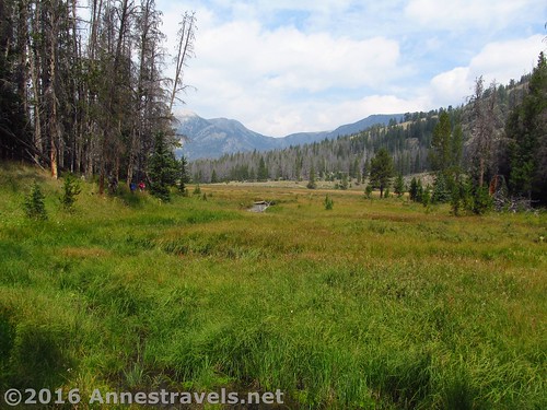
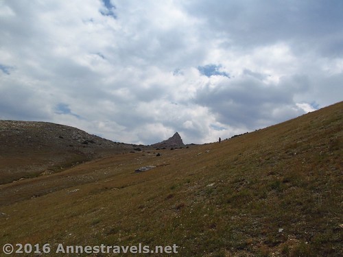
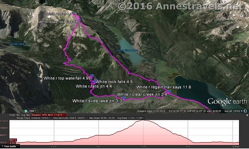
From Slide Creek Falls, continue up the trail toward Slide Lake. Enter a meadow at about 5.25 miles. What we should have done, was, as soon as we entered the meadow, to turn right off-trail across the meadow (watch for water; there’s a stream that makes the area marshy) and then upward through the trees to where the grassy slopes come down to nearly meet the meadow, then continued upward through more grassy slopes to the top of the mountain. This is the #1 way I’d recommend hiking White Rock. From Google Earth, it looks like this route would be fairly simple – continue upward to the top of the ridge, then turn left to walk the ridgeline (mostly meadows, but a few belts of trees to scramble through – there’s plenty of downed logs from somewhat recent fires or blights; I hiked this section on the way down). It’s probably about 1.5 miles from the top of the ridge up to the top of White Rock, but the exact mileage will vary (between the fact that I don’t know exactly where you’ll come out, and my GPS giving me some grief, well, take that mileage number with a grain of salt!)
However, we didn’t do that wonderful, should-be-easy route, because our directions told us to continue around the meadow almost until the trail reenters the woods at about mile 5.4, then turn right to cross the meadow toward Slide Creek. Try to pick up the game / social trail that leads to a set of logs across the stream, then to another set of logs across the second fork. As I said above, I don’t personally recommend the route we took, but I might as well tell you what we did.
Continue to follow the game / social trail through a bit of forest and another small meadow, this one on the side of the mountain. From here, multiple social trails lead upward through a tangle of forest, scree, and generally an insanely steep mountainside. Don’t try to stay on a specific trail; just keep going up and you’ll be headed in the right direction.
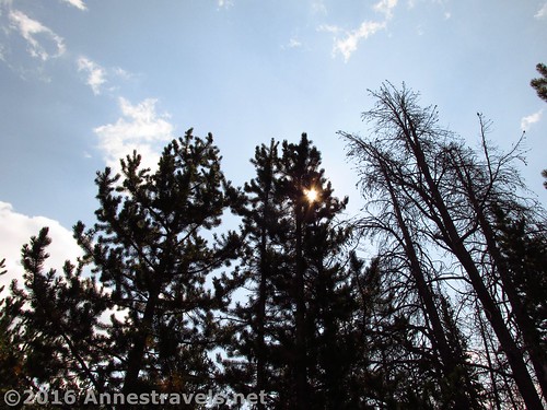
The higher we climbed, the more tangled the trees became, and the more dead trees we encountered. This is obviously an avalanche chute, and plenty of trees have been carried down the mountainside and have ended in a jumble in these woods. Because of this, the trails became more numerous and climbing over dead wood was a necessity rather than an option. As the directions I was following made little mention of an avalanche, I have to wonder if at least some of the mess is from last spring’s thaw – I hear that when the weather turned warm, it did so quickly and all the snow melted very fast (likely causing avalanches – right?)
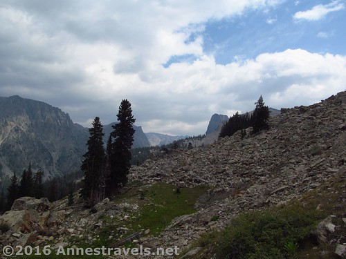
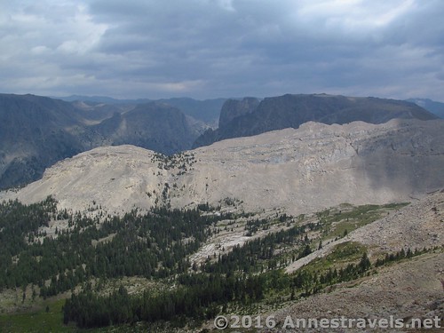
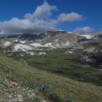
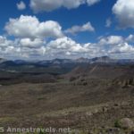
Finally, the woods broke into a scree field about mile 6.5. Below us, so far away, was the meadow where we’d left the trail and the blue waters of Slide Lake, as well as a number of Wind River Peaks, jagged and awe-inspiring. We shot for what looked like a dry watercourse, high above us but more or less straight ahead.
The watercourse was a good move. It was fairly easy to walk in the meadows next to the streambed or to scramble up the streambed, itself. Things would have been easy from here except for three things: 1) we were already tired from the struggle through the woods, 2) we were over 10,000ft. here and thus were having trouble with the thin air, and 3) that meadow is steep; like, really steep. Take five steps and you’re out of breath steep. The only good thing was that the views were amazing, over Slide Lake and up so many Wind River canyons and to so many Wind River Peaks. Take three steps, pause for the view, take another four steps, take a look and get your breath, you get the idea.
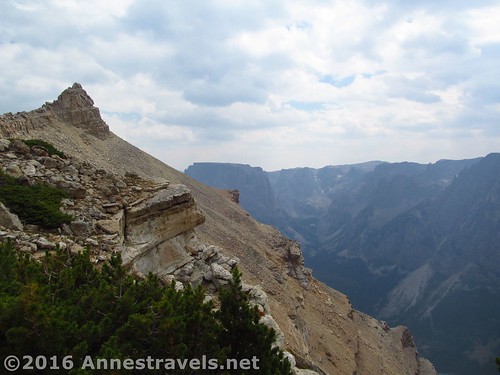
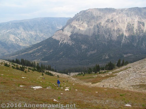
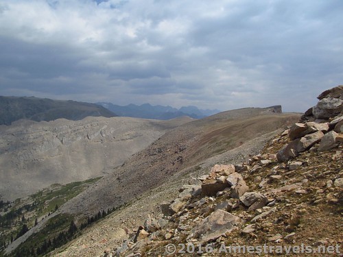
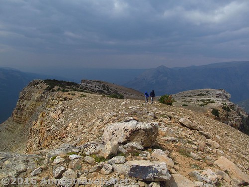
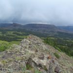
But finally, oh, finally, I saw, over to my left, the summit block of White Rock. I stopped trying for the ridge at the top of the meadow (which actually has as good or better views than near the summit block) and made my way straight for the pinnacle of rock that marked the summit.
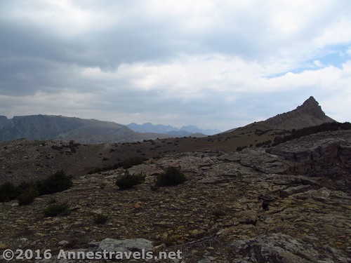
Meanwhile, others of my party had made it to the ridgeline and couldn’t figure out what I was doing. From here, the summit looks impossible to climb (and my guess is that it’s quite dangerous, though not impossible). But I wanted to at least be near the summit, so I kept going. We couldn’t hear each other, anyway, with the wind whipping across the top of the mountain.
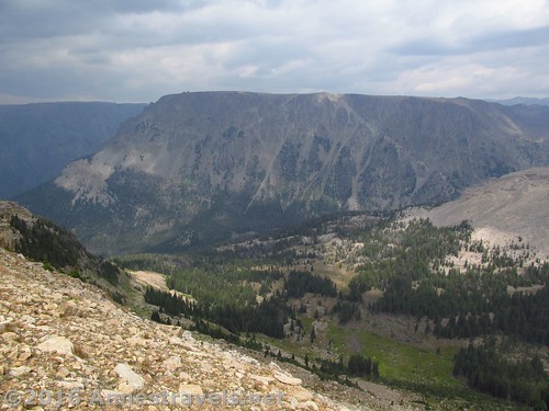
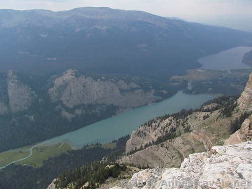
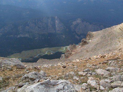
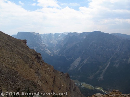
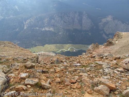
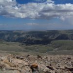
It’s a pity the weather and air conditions didn’t cooperate better. If they had, the view from the top would have been tremendous. Even so, with the clouds and smoky haze, the view took my breath away. We were right on the edge of White Rock, looking down on the Green River Lakes and the river that connects the two. Both lakes and the river were a brilliant, glacial green. The pictures don’t lie; if anything, they tone down the shade. Amazing!
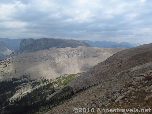
Then there are the mountains. Squaretop is barely visible around the Summit block (you’d probably get a good view of it if you continued beyond the summit; I didn’t have time to check it out – I was dayhiking, remember, and already over 8 miles out), but there are dozens of peaks in almost every direction; flat topped, jagged peaked, sheer cliffed Wind River peaks. The canyons between the peaks are nearly as awe-inspiring as the peaks themselves. Wow!
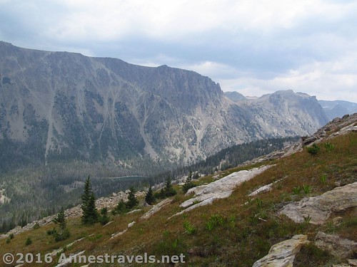
But time was already far too flown to stay long. Before we’d done more than take a few pictures, it was time to head back along the ridgeline, stopping along the way for more pictures of the green lakes and river so far below.
Of one thing we were all agreed: we’d be taking a different route down. But that route (down the Northwest Slopes) is a post unto itself!
Round Trip Distance: 16.6-ish if you go up and down the Northeast Slopes like I’ve described here; the better route would be around 14 or 15 miles; RT for us was about 15 miles
Lowest Elevation: 7,957 ft.
Highest Elevation: 11,093 ft.
Net Elevation Gain: 3,136 ft.
Facilities: Drinking water and primitive toilets at the trailhead. Campground nearby (and opportunities for free-range camping also nearby…oops, maybe I shouldn’t have let that secret out!)
Fees: None
Trail 
![]()
![]()
![]()
Road ![]()
![]()
Signs ![]()
![]()
![]()
Scenery
Would I go 100 miles out of my way for this?
Overall Rating: 
![]()
Key GPS Coordinates for White Rock
Parking: 43.31404N / -109.85827W (43° 18′ 50.5434″ / -109° 51′ 29.772″) (8,029ft.)
Trail beginning: 43.31382N / -109.85838W (43° 18′ 49.7514″ / -109° 51′ 30.1674″) (8,040ft.) (0.0)
Highline Trail / Lakeside Trail Junction: 43.31371N / -109.85839W (43° 18′ 49.356″ / -109° 51′ 30.2034″) (8,049ft.) (50ft.)
Corrals Junction: 43.31450N / -109.85659W (43° 18′ 52.2″ / -109° 51′ 23.7234″) (7,981ft.) (0.12)
Gunsite Pass Trail Junction: 43.31479N / -109.85379W (43° 18′ 53.244″ / -109° 51′ 13.644″) (7,957ft.) (0.3)
Enter Bridger Wilderness: 43.31009N / -109.85127W (43° 18′ 36.324″ / -109° 51′ 4.5714″) (7,982ft.) (0.75)
Clear Creek Canyon Junction: 43.29387N / -109.83237W (43° 17′ 37.9314″ / -109° 49′ 56.5314″) (8,002ft.) (2.4)
Slide Lake Trail Junction: 43.29020N / -109.81016W (43° 17′ 24.7194″ / -109° 48′ 36.5754″) (8,129ft.) (3.3)
Waterfall: 43.29020N / -109.81016W (43° 17′ 24.7194″ / -109° 48′ 36.5754″) (8,481ft.) (4.5)
Top of waterfall: 43.28907N / -109.80901W (43° 17′ 20.652″ / -109° 48′ 32.436″) (8,745ft.) (4.99)
Near top of White Rock: 43.26333N / -109.79981W (43° 15′ 47.988″ / -109° 47′ 59.3154″) (11,093ft.) (8.3)
The gpx file for the hike to the top (and back) of White Rock (including the side trip to Slide Creek Falls) can be downloaded – please note that this and the GPS Coordinates are for reference only and should not be used as a sole resource when hiking this trail.
Download GPX File size: 313.6 KB Downloaded 705 times
(Note: I do my best to ensure that all downloads, the webpage, etc. are virus-free and accurate; however, I cannot be held responsible for any damage that might result, including but not limited to loss of data, damages to hardware, harm to users, from use of files, information, etc. from this website. Thanks!)
Getting to the Trailhead for White Rock
In Pinedale, WY, head north on US-191. After nearly 6 miles, turn right onto WY-352 for 25.3 miles. (This turn is 5 miles south/east of where US-191 leaves US-189). The roads are entirely gravely / dirt after this, but are fairly well-maintained and should usually be accessible for low clearance vehicles. Continue straight onto the Green River Lakes Road for 18.5 miles. Take a slight left to not turn into the campground, then turn left toward the parking areas instead of the boat launch. Near the restrooms, turn right toward the hiker parking instead of the corrals. The parking area is large, but fills up during the summer months.
(By the way, there is technically a way to take a shortcut across the mountains on dirt roads via Union Pass. It’s even more or less on the AAA Wyoming map. Well, I’ve tried it, and it would probably be faster (and certainly easier on your vehicle) to take the paved roads south around the mountains (north might also be faster, but you’ll have to go through Grand Teton National Park, and while you won’t have to pay for that section of highway, the speed limit is also lower!) Scenery-wise, all three routes are really pretty, so enjoy the views of badlands, buttes, and the western side of the Wind Rivers (going around the southern end), views of meadows, trees, and mountain region (not really mountains) via Union Pass, or the Tetons and Togwotee Pass (via the northern route).)
Zoom map out to browse nearby hikes & places of interest
This Week’s Featured Product!
One good thing about Falcon Guides is that they tend to be good. At least, they tend to have nice hikes, enough information to find and hike the trail, and a more-or-less accurate description of trail mileages, etc. So it’s not hard to recommend this book, especially if you don’t mind backpacking through the Winds.


9 responses to “Dayhiking White Rock – Northeast Slopes”
[…] easiest to take the Northeast Slopes approach, climbing through meadows to the summit. Well, that didn’t work out so well, the route being so steep and so tangled with avalanche debris that it took us hours to walk the 3 […]
[…] the next morning we got up early to hike White Rock via Slide Creek Falls – way too long, with fresh avalanche damage on the Northeast Slopes and a burned out forest on the Northwest Slopes, it ended up being a grueling 15 mile hike, about […]
[…] Slide Lake or even all the way up to White Rock (my destination). Next week, we’ll talk about how I reached the top of White Rock via the Northeast Slopes and how I should have reached the top, and the next week, we’ll find out how I went down via the […]
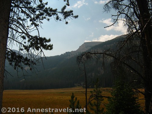
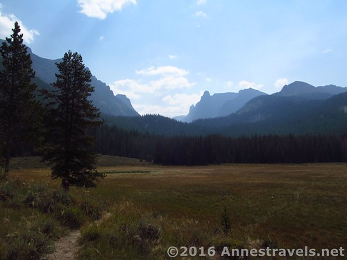
[…] section, if low on spectacular views, with low bushes, tall grasses, and a trail through it all. White Rock rears high above on the other side of the valley. There’s no views of the lake and few of […]
[…] Table Mountain and the Alaska Basin Overlook in the Tetons and some of the trails surrounding the Green River Lakes and Cirque of Towers (but maybe length had something to do with the difficulty of the latter […]
[…] Table Mountain and the Alaska Basin Overlook in the Tetons and some of the trails surrounding the Green River Lakes and Cirque of Towers (but maybe length had something to do with the difficulty of the latter […]
[…] views ever) after being highly disappointed with the views from Cascade Pass, made it to the top of White Rock via a tangled avalanche chute (really, no one was voluntarily going back down that way, even if another way was longer!), and […]
[…] Rock via the Northwest or Northeast Slopes. Now here’s a hike that is incredibly scenic, but just might be too long and hard as a […]
[…] the Clear Creek Natural Bridge, to search for Slide Creek Falls, hike to Slide Lake, or to hike the northeast slopes of White Rock). Shortly after this, stay left, then cross Clear Creek via a log-bridge-with-a-handrail, staying […]