

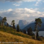
Well, I may not be much into hiking long distances to waterfalls, but when it comes to doing it, it might as well be a waterfall worth visiting. And better yet, the view along the trail should be worth looking at. Such is the trail to Slide Creek Falls above the Green River Lakes in the Wind River Range of Wyoming. The waterfall is something else again; I’ve never seen anything else like it that wasn’t man made (and this is most definitely natural). As for the views along the way, well, they’re totally breathtaking!
Quick Stats
(Affiliate links are present on this page.)
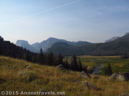
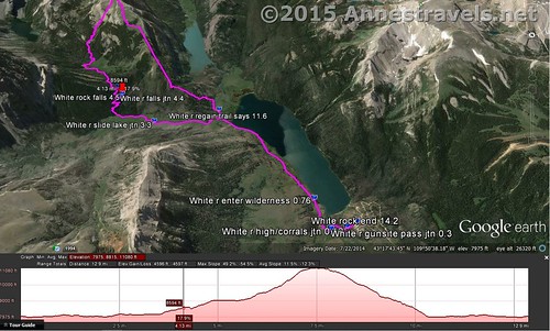
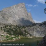
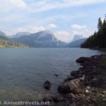
Begin by hiking the Highline Trail from the Green River Lakes Trailhead (follow the link for a description and photos – the views in this section alone are worth the hike). At 2.4 miles from the trailhead, turn left onto the Clear Creek Canyon Trail. The trail climbs quickly above Clear Creek Falls (barely visible; don’t try to get near the edge of the canyon) and then works its way along the valley, well away from the creek in most places. On the first steep ascent, just after the trail junction and before the falls, look back at the Green River Lakes and Squaretop. As the trail continues up the valley, views open up of sheer cliffs and classic Wind River peaks.
Nearly a mile later, arrive at a trail junction and a bridge across Clear Creek. Turn right to cross the creek on the Slide Lake Trail. (As of 8/2015, the trail sign was in very sorry shape – propped against a tree, since it apparently was splintered at the base of the sign. However, the writing was still very readable, so hopefully it will last over the winter or will be replaced.) Personally, I’d love to go back and hike further up Clear Creek Canyon – it’s just so beautiful!
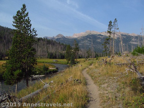
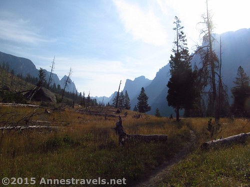
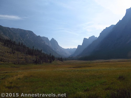
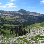
Nearly as soon as the trail crosses the creek, it virtually disappears into the tall grass and various social trails. They all seem to converge eventually, so just take the most-used trail and hope for the best. The views in this section are absolutely stunning. We were a bit disappointed that the valley was filled with smoke from fires in Idaho (our best guess, anyway, since there weren’t any nearby), but it was still so unreal, so spectacular, so breathtaking that we kept snapping pictures and stumbling over the narrow trail / grass tussocks as we tried to hike and take in the view simultaneously!
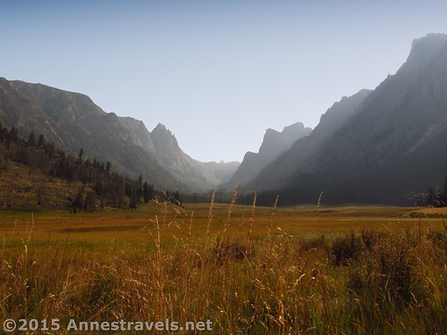
All too soon, the trail enters the woods. And that’s the end of the views. Oh, well.
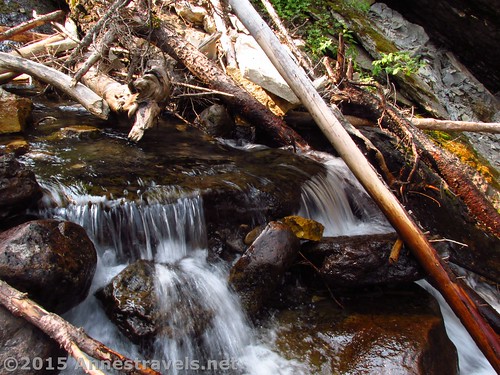
From here, the trail picks up again as easy to follow, but it also begins to switchback relentlessly upward. I think most of your elevation gain is in this next 1.25 miles, as the trail just won’t stop climbing and switchbacking. Finally, at the end of a switchback, deep in the forest, a social trail leads down to the stream (Slide Creek). I can’t describe it any better than that, except to say that it’s 4.4 miles from the trailhead and you’re trying to get to GPS coordinates 43.29020N / -109.81016W (43° 17′ 24.7194″ / -109° 48′ 36.5754″)
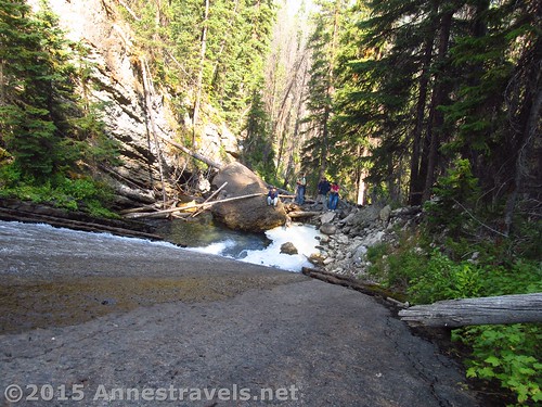
We never would have found it on our own. A fisherman came down the trail and told us to take the social trail at the end of the next switchback to see the waterfall. I figured it would be something like the Gorge Trail along the Ammonoosuc Ravine Trail in New Hampshire. Well, there was less trail, and it was just as steep if not steeper. You are really going to have to scramble to get down – not difficult, just a slight scramble that will likely take your hands as well as your feet.
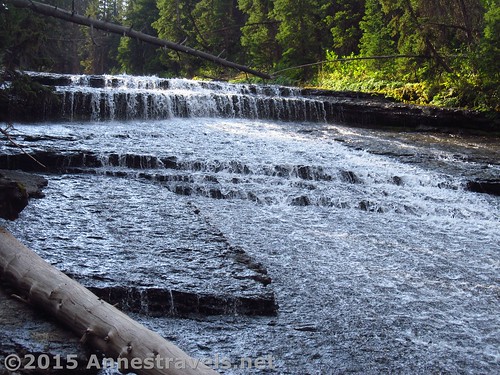
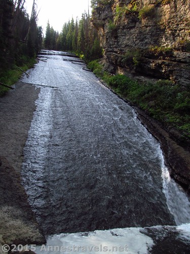
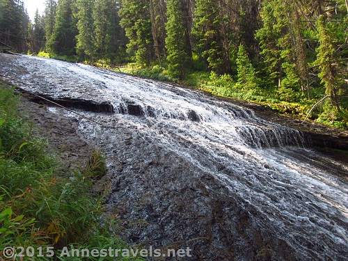
But the waterfall is something completely different from what I was expecting.
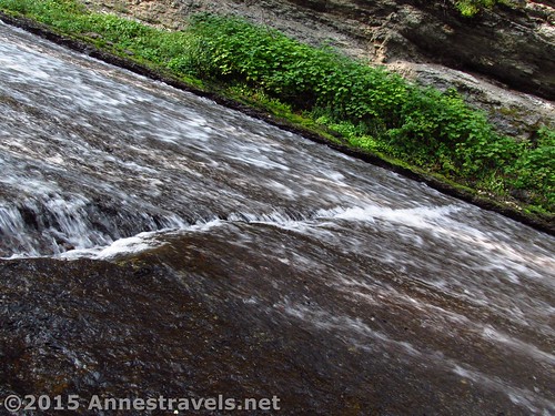
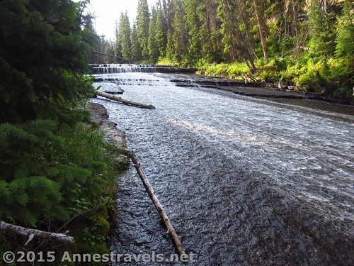
You come out at the base of a small pool. Stretching upward, at least 0.25 miles, probably closer to 0.5 miles, long, is a nearly smooth rock face at a 45 degree angle. The water tumbles down this, broken by only a few very small drops or cracks in the rock face. You have to see it to believe it. The only things I’ve seen that come close are spillways from dams. And those aren’t natural, so it take a lot of the fun out of them.
We looked at the falls for a bit, then climbed up the side (it’s not hard, assuming it’s not snowmelt season). One member of my group walked all the way up to the top of the falls; the rest of us went back down, scrambled back up to the trail, and hiked the trail to where another end of a switchback is pretty literally at the top of the falls. The exact route available will depend on current conditions, but the trail is a pretty safe bet 🙂
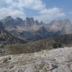
Return to the parking area from here for a 9 to 10 mile round trip hike, or continue upward to Slide Lake or even all the way up to White Rock (my destination). Next week, we’ll talk about how I reached the top of White Rock via the Northeast Slopes and how I should have reached the top, and the next week, we’ll find out how I went down via the Northwest Slopes… three distinct routes to the top of White Rock.
Round Trip Trail Distance: 9-10 miles (Yep, classic “short dayhike” length in the Wind Rivers…)
Lowest Elevation: 7,957 ft.
Highest Elevation: 8,745 ft.
Net Elevation Gain / Loss: 788 ft.
Facilities: Drinking water and primitive toilets at the trailhead. Campground nearby (and opportunities for free-range camping also nearby…oops, maybe I shouldn’t have let that secret out!)
Fees: None
Trail 
![]()
![]()
Road ![]()
![]()
Signs ![]()
![]()
Scenery ![]()
Would I go 100 miles out of my way for this? ![]()
Overall Rating: 
![]()
Key GPS Coordinates for Slide Creek Falls
Cleer Creek Canyon Junction: 43.29387N / -109.83237W (43° 17′ 37.9314″ / -109° 49′ 56.5314″) (8,002ft.) (2.4)
Slide Lake Trail Junction: 43.29020N / -109.81016W (43° 17′ 24.7194″ / -109° 48′ 36.5754″) (8,129ft.) (3.3)
Waterfall: 43.29020N / -109.81016W (43° 17′ 24.7194″ / -109° 48′ 36.5754″) (8,481ft.) (4.5)
Top of waterfall: 43.28907N / -109.80901W (43° 17′ 20.652″ / -109° 48′ 32.436″) (8,745ft.) (4.99)
The gpx file for the hike to the top (and back) of White Rock (including the side trip to Slide Creek Falls) can be downloaded – please note that this and the GPS Coordinates are for reference only and should not be used as a sole resource when hiking this trail.
Download GPX File size: 313.6 KB Downloaded 685 times
(Note: I do my best to ensure that all downloads, the webpage, etc. are virus-free and accurate; however, I cannot be held responsible for any damage that might result, including but not limited to loss of data, damages to hardware, harm to users, from use of files, information, etc. from this website. Thanks!)
Getting to the Trailhead for Slide Creek Falls
In Pinedale, WY, head north on US-191. After nearly 6 miles, turn right onto WY-352 for 25.3 miles. (This turn is 5 miles south/east of where US-191 leaves US-189). The roads are entirely gravely / dirt after this, but are fairly well-maintained and should usually be accessible for low clearance vehicles. Continue straight onto the Green River Lakes Road for 18.5 miles. Take a slight left to not turn into the campground, then turn left toward the parking areas instead of the boat launch. Near the restrooms, turn right toward the hiker parking instead of the corrals. The parking area is large, but fills up during the summer months.
(By the way, there is technically a way to take a shortcut across the mountains on dirt roads via Union Pass. It’s even more or less on the AAA Wyoming map. Well, I’ve tried it, and it would probably be faster (and certainly easier on your vehicle) to take the paved roads south around the mountains (north might also be faster, but you’ll have to go through Grand Teton National Park, and while you won’t have to pay for that section of highway, the speed limit is also lower!) Scenery-wise, all three routes are really pretty, so enjoy the views of badlands, buttes, and the western side of the Wind Rivers (going around the southern end), views of meadows, trees, and mountain region (not really mountains) via Union Pass, or the Tetons and Togwotee Pass (via the northern route).)
Zoom map out to browse nearby hikes & places of interest
This Week’s Featured Product!
A great guide to the Wind River Range, this book covers 40 trails plus suggestions for off-trail hikes.

13 responses to “Dayhiking Slide Creek Falls above Green River Lakes”
That’s pretty amazing. What time of year were you there? I’d hate to hike all the way up to find there was no water in the falls. Of course, Wyoming probably has a better chance of year round water than California I suppose.
Hi Kelly,
I visited in early August – so I heard from the locals, the snowmelt happened all at once earlier in the season, so this must be a year round falls. I can’t imagine how impressive it must be during high runoff.
Anne
[…] the next morning we got up early to hike White Rock via Slide Creek Falls – way too long and with fresh avalanche damage, it ended up being a grueling 15 mile hike, about […]
I’ve climbed the entire Slide Creek Falls. It’s can be done without technical gear–in fact, it’s pretty easy. It’s worth the trouble. At the top of the falls you come right up on the Slide Lake Trail again above all the switchbacks, so you don’t lose any elevation gain by having to descend again to pick up the trail.
Nice to know I’m not the only one who’s tried climbing it. I’m not real big on waterfalls, but this one on the way up the trail is worth the stop!
[…] Slide Creek Falls, continue up the trail toward Slide Lake. Enter a meadow at about 5.25 miles. What we should […]
[…] 2.4 miles (this is the way you’d turn to get to the Clear Creek Natural Bridge, to search for Slide Creek Falls, hike to Slide Lake, or to hike the northeast slopes of White Rock). Shortly after this, stay […]
[…] picture of Clear Creek Canyon in the Wind Rivers of Wyoming taken with the […]
[…] Slide Creek Falls, Wind River Range, Wyoming […]
[…] Slide Creek Falls in the Wind River Range of Wyoming […]
[…] Epic Hikes in the Western US – The photo (of Clear Creek Canyon in the Wind Rivers of Wyoming) is one of my favorites from the guest who inspired this […]
[…] Slide Creek Falls. The falls isn’t a known destination, in fact, you might not even know it exists unless you saw it on a topo map. But since it runs right next to the Slide Lake Trail, and it’s only 4.5 miles from the parking area, it’s quite easy to visit (and you get to see some truly epic Wind River scenery en route!). […]
[…] Epic Hikes in the Western US (Pt. 1) – picture from the Slide Lake Trail in the Wind Rivers of […]