
After hiking the Ammonoosuc Ravine Trail in the Snow, we decided to descend by the same trail after hiking to the top of Mount Washington via the Jewell Trail – just to see what it was like when it wasn’t covered with snow. (Answer: we kept looking at each other and saying, “We climbed this in the snow?!?!?) On our way up the Ammonoosuc Ravine Trail the first time, we’d noted a side trail 0.2 miles (0.3 km) from Gem Pool with a rickety sign stating that “The Gorge” was 8 miles down the trail. None of us could believe that anything was 8 miles down the side trail, but since we didn’t have the time or interest in hiking another 16 miles out of our way, we decided to keep walking right past that trail. On the way down, however, since it wasn’t too late, we were waiting for group members to catch up anyway, and there wasn’t any snow slowing down our progress, we decided to give “The Gorge” trail a try. It turned out to be a rough 80-yard-long trail to a beautiful waterfall – I’m not sure how tall, but it is quite high, lovely, and well worth the side venture. Actually, if you love waterfalls, the trek up to The Gorge would make a lovely (and mostly flat) 3.2 mile (5.1 km) day hike to two beautiful waterfalls – not only will you get to see the cascade in The Gorge, but you’ll also pass the lovely waterfall at Gem Pool before reaching the trail to The Gorge.
(Affiliate links are present on this page.)
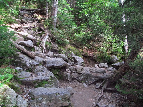
From the parking area, the trail is slightly uphill, following an old roadbed (or at least, that’s what it looked like). It is not long before you’ll come out of the trees; the Cog Railway Station is on your left. Keep walking uphill to the trail on your right (keep a watch for a break in the trees). You want this trail; it will take you 0.3 miles up to where it meets the Ammonoosuc Ravine Trail. This trail is fairly rocky and has plenty of roots, so watch your step. The terrain only gets rougher after you meet up with the Ammonoosuc Ravine Trail (you could also park in the Ammonoosuc Ravine Trail Parking Area, but then you’d have a mile-long (1.6 km) trek (with a stream crossing) instead of 0.3 miles (0.5 km) to this junction, and who’d want to walk further than they have to? 🙂
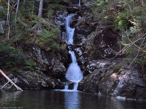
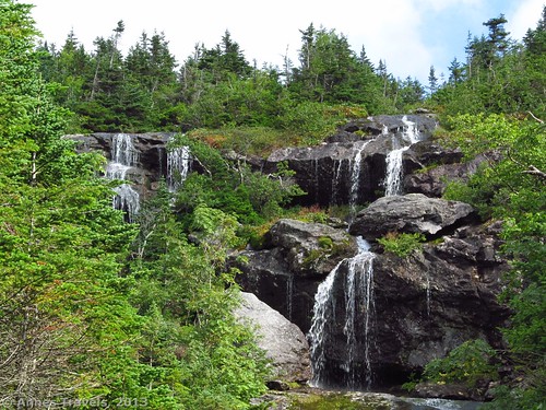
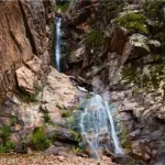
At the Ammonoosuc Ravine Trail junction, a sign should point toward Mount Washington; you’ll want to go straight and follow this sign. As I said above, the rocks and roots make for some rough going, but it’s quite doable. After hiking 1.1 miles (1.7 km) from the Ammonoosuc Ravine Trail junction (a total of 1.4 miles (2.2 km) from the trailhead), the trail will take a sudden sharp left turn and cross the Ammonoosuc River, which you’ve been following up until this point. Here is Gem Pool, a beautiful dark pool with a lovely little waterfall cascading into it; very nice and romantic. This is a good place to rest before you continue; the trail ahead is even rougher than what you’ve faced until this point, and it begins to climb, as well!
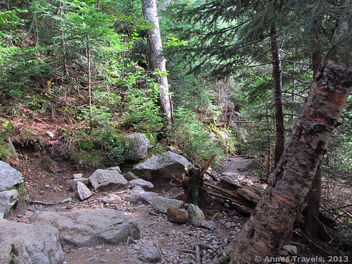
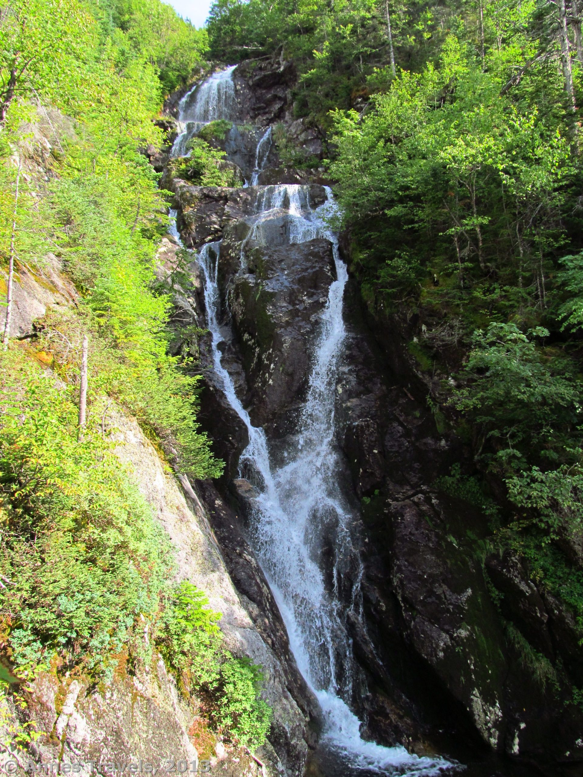
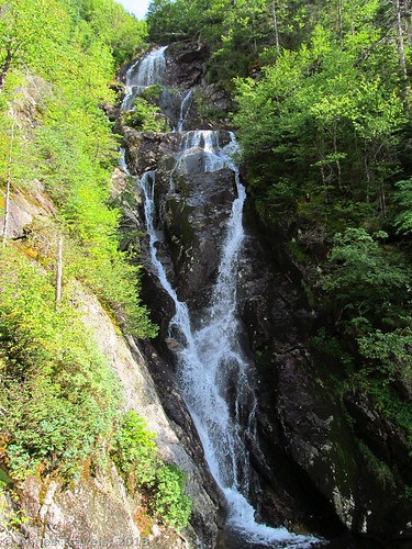
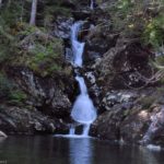
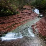
The trail after Gem Pool begins to climb steeply, often over large rocks that can act like steps (or obstacles, depending on how you want to look at it). Thankfully for you, you’ll only have hike this section for 0.2 miles (0.6 km) to a spur path on the right. When I hiked this in May 2012 a sign read, “The Gorge, 8 miles”; when I returned in August, the trail was unmarked. Even if it is unmarked, it is not very easy to miss since it’s a fairly large, well-beaten path (and much better defined than the many social trails that go off of the Ammonoosuc Ravine Trail). Turn down this trail, which will quickly begin descending. The trail itself is only about 80 yards long, but you’ll likely find yourself climbing over trees and rocks; in one place, you will even have to scramble down a 4-5 foot drop (not difficult; and not too hard to get back up, either).
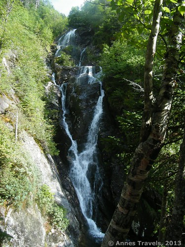
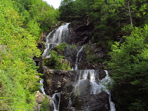
Then, you’ll suddenly come out in a small clearing on the very edge of The Gorge. Look upstream and you’ll see the cascade – tall, graceful (in August; earlier in the year it would likely be more raucous), and a lovely place to spend a bit of time. It’s a peaceful place, and it doesn’t seem that most people come down here.
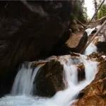
Return by the way you came, or you can continue up the Ammonoosuc Ravine Trail to Lake of the Clouds, about 0.8 miles (1.3 km) away. There are many more beautiful waterfalls along this route; but be prepared to scramble on the rocks near the waterfalls and for the trip back down! (For my review of the upper part of the Ammonoosuc Ravine Trail, click here).
Getting to The Gorge
Take US 302 in New Hampshire to the town of Bretton Woods. Actually, if you’re coming from the north, you don’t want to drive all the way to the town. Just before the town, on the north side, US 302 will cross a river (the Ammonoosuc River). Don’t cross the river (or, if you’re coming from the south, go through the town and cross the river). Follow the signs for the Cog Railway down a road that crosses the railroad tracks. I believe this is called Base Station Road. Drive about 6 miles (9.5 km) down the road almost until you arrive at Mansfield Station (the Cog Railway Station). A dirt parking area will be on your right. Park here.
Round Trip Trail length: 3.2 miles (5.1 km)
Facilities: None at the trailhead, although Mansfield Station likely has some
Fees: None that I know of; there may be a $3 parking fee (not sure) payable at the Ammonoosuc Ravine Trailhead (the parking area about 0.5 mile (0.8 km) from Mansfield Station that is labeled “Trailhead Parking”). If so, the national park/national forest passes are also accepted (we figured we had an Interagency Pass so we were ok).
Trail 
![]()
![]()
Road
Signs ![]()
Scenery ![]()
![]()
Would I go 100 miles out of my way for this? ![]()
![]()
![]()
![]()
Overall Rating: ![]()
![]()
This Week’s Featured Product!
A book with over 400 waterfalls in New England (including The Gorge)! For the waterfall lover, or those who simply love a destination to hike to in Connecticut, Maine, Massachusetts, New Hampshire, Rhode Island and Vermont.

2 responses to “A Beautiful Waterfall: The Gorge in Ammonoosuc Ravine”
[…] at the end of the next switchback to see the waterfall. I figured it would be something like the Gorge Trail along the Ammonoosuc Ravine Trail in New Hampshire. Well, there was less trail, and it was just as steep if not steeper. You are […]
[…] The Gorge, Ammonoosuc Ravine, New Hampshire. The Ammonoosuc Ravine Trail is best known as a route up Mount Washington. However, it boasts multiple impressive waterfalls, not the least of which is on a short side-trail simply signed “The Gorge”. A multi-step waterfall at the end of the steep route is sure to leave visitors in awe. 3.2 miles RT […]