

After my adventures in the snow trying to climb the Ammonoosuc Ravine Trail, we decided to try to get to the top of Mount Washington again later in the summer. So, last weekend, we set off again, this time via a trail no one in the group had ever done before: the Jewell Trail. This trail leaves from the same parking area as the Ammonoosuc Ravine Trail, but follows the Cog Railway up to the summit. Honestly, the Jewell Trail is better than the Ammonoosuc Trail, due to the fact that it’s in better shape and offers very good views (I think…unfortunately, the mountain was shrouded in clouds most of the day!). The younger members of my group were also thrilled that they could see the train make its way up the mountain. The Jewell Trail route up to the summit is a little longer than the route via Ammonoosuc Ravine (5.1 miles (8.2 km) versus 4.5 miles (7.2 km) and 3,900 ft. (1,188 m) versus 3,800 ft. (1,158 m) elevation gain), but if you’ve tried both, I think you’ll agree that the Jewell Trail is easier overall!
(Affiliate links are present on this page.)
There are two trailheads for the Jewell Trail. The first is the Ammonoosuc Ravine Trailhead, located on Base Station Road, 5.5 miles (8.8 km) from US 302. To get to Base Station Road, take US 302 to the town of Bretton Woods. If you’re coming from the north, you don’t want to drive all the way to the town; just before the town, on the north side, US 302 will cross a river (the Ammonoosuc River). Don’t cross the river. (If you’re coming from the south go through Bretton Woods and cross the river). Follow the signs for the Cog Railway down a road that crosses the railroad tracks. This is called Base Station Road. Drive 5.5 miles (8.8 km) down this road to a “Trailhead Parking” parking area on your right. A sign will mark this. As soon as you enter the parking area, you will be faced with a signboard. There is a $3 fee to park in this area, but you get a signboard with maps and a primitive restroom. The trail begins across the road from the parking area (it’s well-marked).

The second trailhead is less than a mile (maybe a kilometer) further down Base Station Road towards the Cog Railway. The railway station is visible from the parking area; this is a dirt parking area that is called “Hiker Parking”. A sign will point to it and ban all hikers from parking beyond this point. There is no fee to park in this area (to my knowledge…there’s no signboard, either). I parked here, then hiked up the old road at the west (mountain) side of the parking area to the railway station parking area. Go to the back of the station and descend the steps. Here you’ll find (at least in the summer; I’m not sure about the rest of the year) a variety of steam-powered machines. The younger members of my group really enjoyed seeing these, and I agree that they’re quite nice. Beyond these, in the woods, is a sign for the Jewell Trail. I wonder if this sign exists except in summer; I said in my Ammonoosuc Ravine Post that there was no sign in this area, and there was in August…so these may be seasonal signs. Anyway, you should be able to locate the trail beyond the steam equipment even without the sign. Cross the Cog Railway tracks and head over the bridge and up the trail.

The Jewell Trail begins quite steeply, with plenty of rocks. I think this is to discourage hikers. But don’t turn back—the trail soon gets better, ascending less steeply and on a better trail. It wanders through the woods for some time, eventually connecting with the Jewell Trail from the Ammonoosuc Ravine Trailhead. The trail in this section has rocks, but is nowhere near as rocky as the Ammonoosuc Ravine Trail (nowhere near!). It switchbacks some, but mostly you’re following the ridgeline, so you’re ascending with that instead of a man-made route up the mountain.

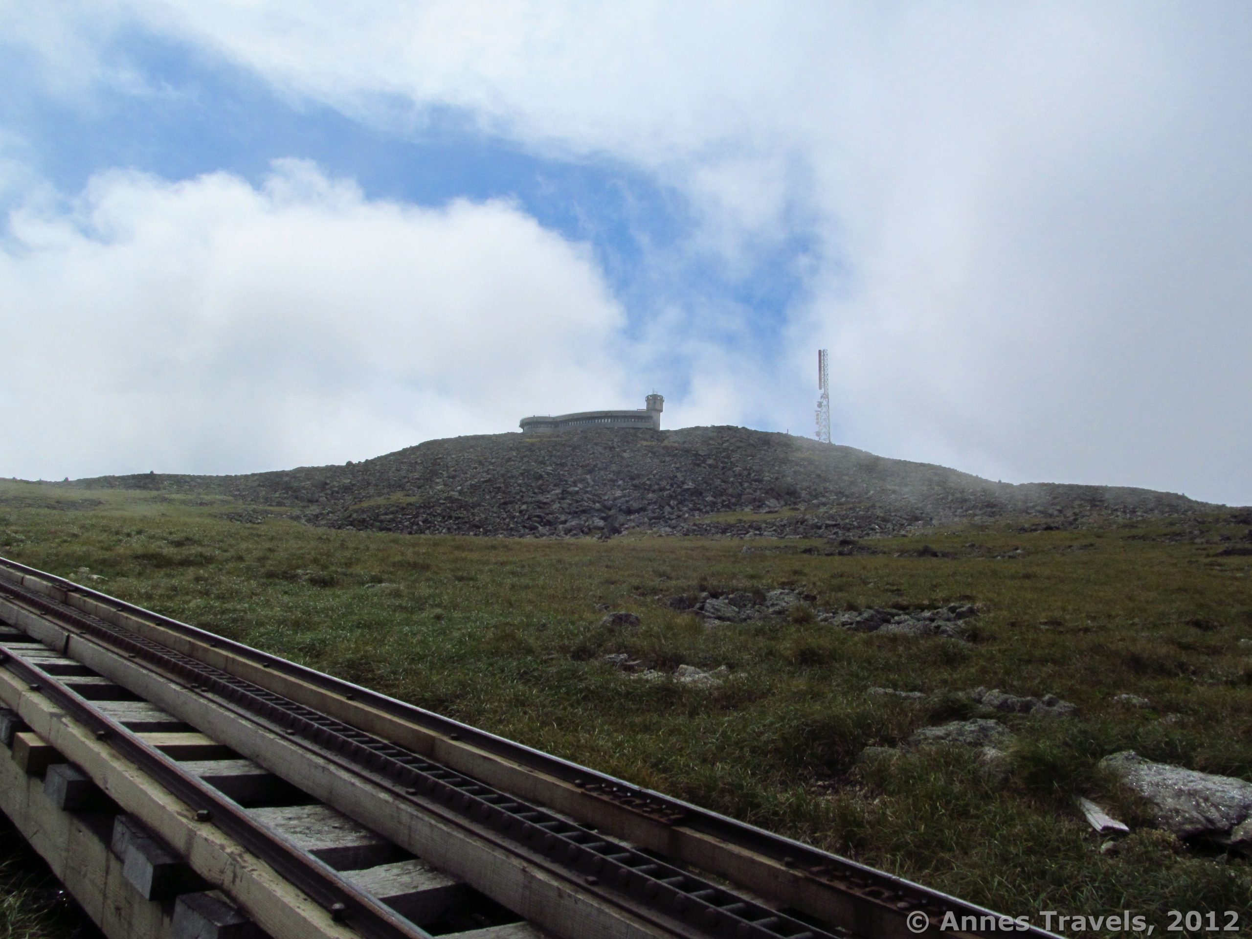
At about 3 miles (4.8 km), you’ll suddenly break through the trees and find yourself on the ridgeline with rocks and bushes all around you. You will pass a few spots before this that seem to signal you’re almost out of the trees, but then you enter the forest again. Here, though, you really are out of the trees, and will be for the rest of the hike. You will also get your first look at the Cog Railway, over on your right. We hit this spot right as the steam train, which only ascends the mountain once a day, was going up; very exciting! Keep climbing the rocky, switchbacking path up the side of the mountain. (Follow the cairns and the blazes—there were no blazes in the woods, but there are here.) The views from here should be good. As it was, we were completely clouded in, so we rarely saw much besides swirling clouds!

At 3.7 miles (5.9 km), you will hit the Gulfside Trail (which is part of the Appalachian Trail). Turn right. This trail is very well maintained; someone has done a lot of work to keep the rocks fairly flat, so it’s not a hard hike. Three tenths of a mile (0.48 km) later, you’ll cross the Mount Clay Loop Trail; keep going straight up the hill. Not long after this (about 0.1 mile (0.16 km)), you’ll come to a signpost. The Gulfside Trail goes left up the mountain, but several of us opted to go straight (on the Westside Trail) a very short distance to the Cog Railway. We watched two trains go down the mountain (one of which was the steam train), and then hiked up the trail near the tracks. No one seemed to mind. I know they don’t want you hiking next to the tracks the whole way up, but up here no one seemed to care how close we were to the tracks. Up farther, the Gulfside Trail and the one we followed cross the tracks—there’s no sign here, or even an easy way to do it. You just have to cross the tracks some time and keep following the trail up towards the top of the mountain. Enjoy the video of the train on the tracks!

The last 0.2 miles (0.32 km) of the trail are more difficult, over rocks and large scree (keep following the signs for Mount Washington…I think you’ll have to switch over to the Trinity Heights Connector to reach the top). It’s very doable, but you just have to get up it! Keep following the cairns and blazes. All along this we kept getting glimpses of the top as the clouds moved out of the way, and then shrouded the peak from view again. It was really cool, especially since we couldn’t see our goal; it just kept getting closer each time we could peek through the clouds. So, suddenly, we found ourselves in the middle of a great throng of people…on the summit! The trail takes you up just behind the Tip Top House (formally a hotel, and now a museum (small fee); this is the oldest building on the top of Mount Washington). Just to your left is the summit, with a sign marking it. We waited our turn in line to get a picture…proof that we’d been to the top!

From here, there are several places you can go. The observation area is just to the left of the sign; I highly recommend this. We didn’t have much of a view down the mountain, but we did get a great view of the trains. Inside this building (under the observation area) are visitor services (including restrooms and water; there’s also a post office if you need to mail something). In the basement (go in the doors and then turn right and down the stairs), there is a hiker’s lounge (i.e., tables and chairs). It was cold and windy enough that we were thankful to eat lunch there. I recommend that you go over to the gift shop on the other side of the mountain; on one side of the shop is a sign that talks about the highest wind speed ever recorded. Inside, the gift shop is very small, but the merchandise is quite reasonably priced. We bought a post card and then mailed it at the post office under the observation area.

To return to your vehicle, there are two main trails down: the Gulfside Trail, which you came up, and the Crawford Path. We opted to go down the Crawford Path to the Ammonoosuc Ravine Trail, since this takes you back to the same parking area as the Jewell Trail. This was very beautiful, but a big mistake. I’m sure the Jewell Trail would be easier to go down than the slickrock on the Ammonoosuc Trail…oh, well…next time!
Round Trip Trail Length: 9.5-10 miles (15.3-16 km)
Facilities: Pit toilets at the parking area; flush toilets, water, food services, etc. at the top
Fees: $3 per day to park
You can read more about the Cog Railway at http://www.thecog.com/
Trail 
![]()
![]()
Road
Signs ![]()
Scenery ![]()
Would I go 100 miles out of my way for this? ![]()
Overall Rating: ![]()
This Week’s Featured Product!
If you’re looking for even more hikes in the White Mountains, check out this guide from the Appalachian Mountain Club.
15 responses to “The Jewell Trail up Mount Washington”
This is my first time visiting your website, however I discovered a variety of interesting information. From the amount of feedback on your posts, I assume I’m not the one one! Hold the good work up.
Wonderful weblog! Is your theme customized made or did you obtain it from somewhere? A design like yours with just a few easy adjustements would actually make my blog shine. Please let me know where you got your theme. Bless you
Heya i am for the first time here. I discovered this board and I find It truly helpful & it helped me out much. I hope to provide one thing back and help others such as you aided me.
great issues altogether, you just received a new reader.
I was looking at some of your blog posts on this web site and I believe thi web website is real instructive! Keep posting.
Thank you for this blog article, it was just what I was searching for. There is so much information here, so I thank you so much.
[…] Snow, we decided to descend by the same trail after hiking to the top of Mount Washington via the Jewell Trail – just to see what it was like when it wasn’t covered with snow. (Answer: we kept looking at […]
How long did it take you to get to the summit?
Mary, it took a few hours, I think…we started by 8am or so and were up to the top before noon. But we’d also just spent a couple weeks hiking a lot higher than that, so we were in pretty good shape. Hope that helps.
He Anne,
Thank you so much for your information on the Jewell Trail. My daughter works on top of Mt. Washington and wanted to take me up the Jewel trail because it’s the easiest. Im not a seasoned hiker like her. Is it a scary hike, do you have to climb huge high boulders and have to have help to get up? and is the trail partly on cliff parts where your having to hold onto the mt? thanks again!
Hi Eileen! The Jewell Trail is certainly easier and has fewer scramble / boulder sections than the nearby Ammonoosuc Ravine Trail. It’s also the least rocky ascent up Mt. Washington. As I recall, there aren’t any really difficult sections; just steep uphill and an occasional switchback, with some boulders to walk around (no cliffs, and nothing an average solo hiker couldn’t do – the hardest part for me was scrambling over the railway tracks nearly at the top, and even that wasn’t particularly difficult). Hope that helps and you’re able to enjoy some time with your daughter!
The Jewel trail took me 4 hrs to hike up. I kept gawking at….everything…although there are no waterfalls. waaa!!! Switchbacks make it more doable than then Ammo….which kicked my butt going down. I’d do the Jewel up, over the top, stay at the hut, Ammo down again, once my right knee stops hers whining!!!!
So glad you made it! Mt. Washington is such an epic climb!
[…] Range and Jewell Trail, White Mountain National Forest, […]
[…] DIY Bug Screens, The Best (and Worst) Day Hikes in Anza-Borrego Desert State Park, Coyote Gulch, Jewell Trail, Buttermilk Falls, etc. So as not to be a stuck record, I’ll only feature the most popular […]