

The tower at the top of Mount Greylock
Think beautiful views…think green mountains all around you…think historic structures…think memorial towers…think J. R. R. Tolkien… Wait…Tolkien, in the middle of mountains and historic structures? Yes, think Tolkien! On top of Mount Greylock in the Berkshires of Massachusetts (you knew that if it was like Tolkien there had to be a “shire” in the name!) a tower was constructed to commemorate all who have fallen in war. However, the tower, in my opinion, looks like it came out of the Lord of the Rings, or another of Tolkien’s books about Middle Earth. One of my group members even took a picture of the tower and then put runes (Middle Earth writing) around the outside of it. As an added bonus, Mount Greylock also offers nice views of the surrounding area and is the highest mountain in Massachusetts. You can either drive to the top of the mountain or take a 3.2 mile (RT) trail to the summit. I’ve never driven the road, as it was closed when I visited, but I’ll tell you about the Thunderbolt Trail that zigzags its way up to the Appalachian Trail, and from there to the top of the mountain. It’s a steepish hike, but worth it to see the tower and the views from the top.
To get to the trailhead, from the town of Adams, go north on Highway 8 and take a right onto Friend Street. This will be just before the Adams Wastewater Treatment Plant (if you’re coming from the north rather than from the town of Adams, Friend Street should be your first left after the plant). At this intersection, there should be a park on one side of the road, a 7-Eleven on another side of the road, a garage of some sort on the third corner, and a car dealership on the fourth corner. Drive on Friend Street for 1.5 miles—the name will change to W (or West) Road after 1.1 miles. Turn right onto Gould Road; you will have just passed another road on your left and a light blue/grey house will be across the street from the intersection. Drive on this road for approximately 1 mile to the end of the road. After 0.5 miles, the road will change names to Thiel Road—some say that you will have been on Thiel Road since you turned onto what I called Gould Road. However the road signs work, you want to take Thiel Road all the way to the end, where you’ll find a small parking area. Actually, there are several parking lots in this area, and the road may look like it continues. You want to park near Hoxie Brook, a pretty little stream that tumbles down rocks towards the valley below. The children in our group had a lovely time wading in the water after we came back from our hike, but more on that later.

The trail through the open space in the woods
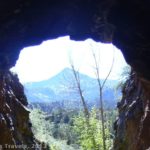
The trail begins by climbing upward, paralleling Hoxie Brook. After a short while, you will intersect an old ski trail, better known as the Thunderbolt Ski Trail. The trail is popular with cross-country skiers and snowshoers in the winter (black diamond ski rating). The trail at first, although climbing steadily, isn’t too steep. Then, suddenly, you will come out into a patch of open forest where the trail really begins to climb. What I mean by open forest is that the hillside is surrounded by trees (so you don’t get a view) but there aren’t any trees around the trail—it’s an open space full of low bushes within the forest. Keep climbing up this hill (I certainly wouldn’t want to ski down this!) and then upwards as the trail continues to ascend towards the Appalachian Trail. Before you reach the ridgeline and the Appalachian Trail, you may be directed up a different trail (the Bellows Pipe Trail) due to erosion on the Thunderbolt Trail. This is ok, just follow the signs for the Mount Greylock Summit.

Wildflowers along the trail
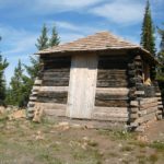
After about 1.5 miles, you will reach the Appalachian Trail. Turn left, following the signs for Mount Greylock. In this area of the trail, you will have some nice views of the town of Adams to your left as you hike, somewhat upward, along the ridge towards the top of the mountain. You will cross the road to the top of the mountain once; you are now very close to the summit. The trail will take you near the parking area at the top; go up to the parking area and across it to reach the war memorial (Tolkien-like tower). To the right of the parking area is a historic lodge where visitors can spend the night (I didn’t go inside). I’ve heard that you can climb to the top of the tower, but it wasn’t open the day that I visited, so we simply admired it from a distance.

View from the Appalachian Trail
One of the unique things about Mount Greylock is, unlike other mountains in the area, this mountain goes straight up and straight down—it’s not really the highest point in a strip of mountains. It is also the highest mountain in the state. Because of these two features, it offers fairly good views in many different directions. Trails go off in various directions around the summit, so that you can take in these various views. We opted to go to the left of the parking area (when you’re facing the tower) down a little trail to a hut on the side of the mountain. The view from here wasn’t great (it’s in the middle of some trees) but there were picnic tables and a woodstove inside, so it was a nice place to eat a picnic lunch.
Return by the way you came. By the time we got back to the parking area, we were all pretty hot and tired, so we took off our shoes and waded in Hoxie Brook. We had the parking area virtually to ourselves on a weekday in late June, so this was a nice, quiet way to end the hike (if you can call making dams in the creek and then letting all the water loose quite!). The road to the top was closed, but even so there were many people on the top. I’d hate to think of how crowded the top of the mountain would be on a weekend when the road was open to the public!
Round Trip Trail Distance: 3.2 miles via the Thunderbolt Trail; just about 0 miles if you take the road
Facilities: None at the trailhead; restrooms at the top
Fees: None if you hike; $2 to park at the top of the mountain
Trail 
![]()
![]()
Road ![]()
Signs ![]()
![]()
Scenery ![]()
Would I go 100 miles out of my way for this? ![]()
![]()
Overall Rating: 
![]()
This Week’s Featured Product!
Discover more hikes in the Berkshire Mountains with this guide compiled by the Appalachian Mountain Club.


Pingback: Up the Cleft in the Rock: Table Rock - Anne's Travels