
The last few weeks have been a fun whirl of work and adventures! We never left New York, but we hiked and biked and kayaked old and new trails and routes. One of the new routes was a somewhat random trail I found in the heart of the Adirondack State Park: Through the forest and along creeks, then up, through, and over boulders and ladders, and finally up one last ladder to a great view from Summit Rock in Indian Pass! Actually, there are two great views from Summit Rock/Indian Pass: One is rather expansive toward Henderson Lake and Santinoni Peak (a 46er); the other is up the almost-sheer face of Wallface Mountain. Both are very impressive, so I highly recommend the hike if you don’t mind a bit of mud…
Quick Stats
Note: Some of the links in this post are affiliate links. If you click one and purchase something, I may earn a small commission without an extra cost to you.
We started out not so very early on an early fall morning. The parking area at the Upper Works was almost full, despite the fact that it was a Friday in the off-season. Still, we buckled on our packs and headed up the road through the old iron district known as the “Upper Works.” Actually, the one house still standing near the trailhead is where Theodore Roosevelt was staying with his family when he received the news that he was now president of the United States because William McKinley had died.

Speaking of Theodore Roosevelt, I’ve heard that he and his children used to play a game when they were on vacation. You had to choose a compass point and then follow that compass point in exactly a straight line. If you came to a mountain, you hiked over it – even if it was straight up. If you came to a tree, you climbed it. If you came to a river, you swam it. If you met a bear… well, I never heard that any of them met a bear! But after hiking through this area, it gives a whole different spin on how crazy (and maybe fun) that game would be to play!

There are quite a few signs along the gravel road beyond the house and gate. For whatever reason, the park has shut down the road between the Upper Works Trailhead and the actual trailhead for Indian Pass. There are signs about the Upper Works and plenty of old ruins along the road. After 0.2 miles, you’ll come to the signboard at the actual trailhead.

Follow the trail into the woods. It’s fairly flat and not too muddy for the first bit; cross over the Hudson River on an old road bridge (the headwaters of the Hudson River are just upstream of here), then come to a trail junction for the Henderson Lake Dam at mile 0.4. Turn right, following the sign for Duck Hole, Indian Pass, Lake Colden Dam, and Mt. Marcy. There was another sign on the post, as well, but unfortunately, the wording had peeled off and I couldn’t read it.

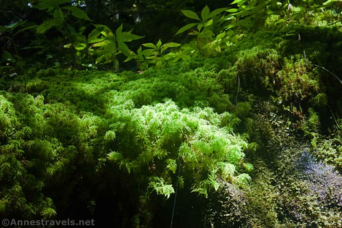
The trail continues to be in fairly good repair, rolling only slightly, to 0.6 miles, where a trail sign points up the Calamity Trail (not necessarily the name I’d choose for a trail… lol.) Again, there are more peeling signs, but you can still read one that points straight/left toward Duck Hole and Indian Pass. The trail narrows after this junction; on a rainy morning, the ferns and moss were quite nice.

At 1.8 miles, you’ll come to another trail junction. Duck Hole, Lake Placid, and the Seward Trailhead (Corey’s Road) turn left; you want to go right toward the Henderson Lean-to, Wallface Lean-to, Indian Pass, and the Adirondack Loj (pronounced lodge). Both signs are peeling badly, but they’re still readable. A quarter mile beyond the junction, you’ll be able to see the Henderson lean-to through the trees, up on the hill to the right – social trails lead up to it.

The next (and the final official for quite some time) trail junction is at 2.4 miles – keep an eye out for this junction on the way back, as it can be easy to miss. The Calamity Crossover Trail turns right. However, you want to turn left toward the Wallface Lean-to, Indian Pass, and Adirondack Loj. Shortly after the junction, you’ll descend to cross a large bridge over Indian Pass Brook.

This is about where the trail begins to be muddy and/or flooded. There are plenty of sections of dry trail, but be ready to get your feet wet in a few places. Helpful hikers/workers have put down branches in many places, so it could be a lot worse. Keep your eyes and ears open to Indian Pass Brook on the right – there are occasionally waterfalls.

The Wallface Lean-to is at 3.1 miles, then, half a mile later, we found a beaver dam in Indian Pass Brook. It was very interesting to see how the beavers had made the dam and to find the gnawed-off trees nearby. I expect the dam will probably flood the trail at some point in the future if other action isn’t taken, but for now, it’s pretty neat.

This section along the brook is pretty much flat, which is nice. It won’t be flat for that much longer, so enjoy it while you can.

At 4.5 miles from the trailhead, a social trail marked with a large cairn strikes off on the left. This is the climber’s trail up to Wallface Mountain. It’s a favorite with rock climbers; some hikers also climb it even though the views from the top are quite lacking. You’d be better off getting your views from the base of the Wallface if you decide to take that trail. Soon after the junction, the Indian Pass Trail turns suddenly to the right to cross over Indian Pass Brook at a pebbly, rocky crossing (we didn’t get our feet wet). Pause for a moment to have a snack or just take a breather before continuing up the trail. You’ll need it.

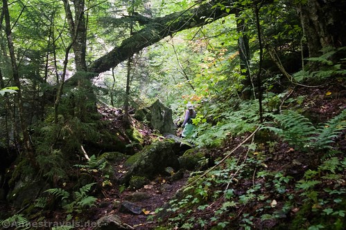
The trail after the brook crossing takes on a completely different face. Instead of a flat trail through the forest, the trail suddenly shoots upward through (and sometimes over) large boulders. I’ve read that some are as tall as a two-story building; I’d put some at close to twice that. These rocks are huge!

Among the rocks are ferns and mosses and trees clinging to what little dirt they can find in crevices. It’s such a cool place!

To top off the excitement, there are 2-3 ladders (depending on how you want to count them) up some of the boulders. Use care, as the ladders are slippery and not exactly for those with a fear of heights. But we made it!

It’s only about 0.75 miles between the stream crossing and the junction for Summit Rock in Indian Pass. The junction isn’t well-marked from this direction, but there is an obvious but very short ladder on the left that marks the route out to Summit Rock. A sign on a tree reads, “Trail To Indian Pass Summit Rock Look Out.” Turn left, climb the ladder, and follow the trail a very short distance to the view.

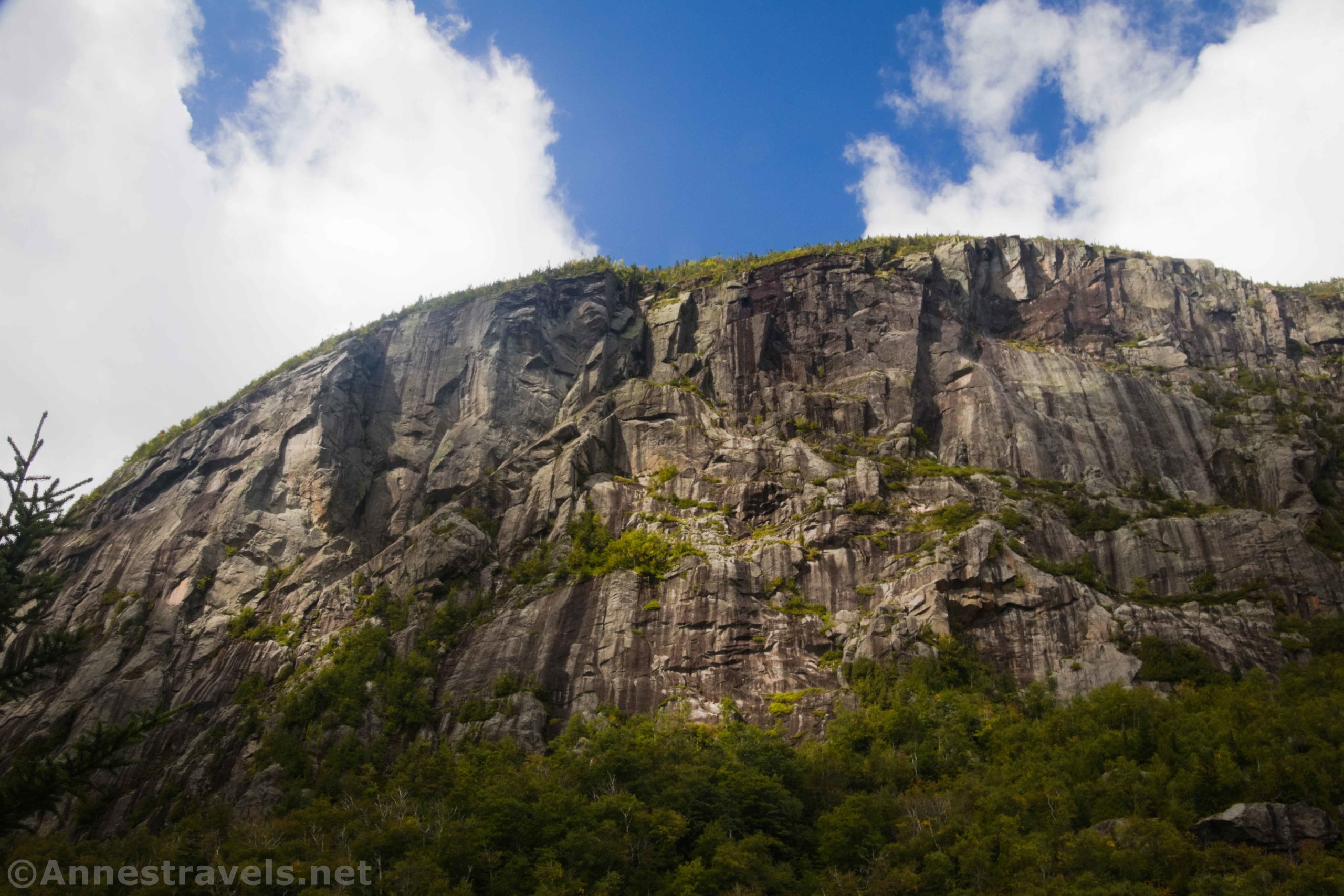
As I said at the beginning of this post, there are two viewpoints on Summit Rock. The first one (the safer one) is of Wallface Mountain. It’s very impressive; you can also look out a little bit toward Santanoni Peak (a 46er) and up into Indian Pass. The trail is worth it for this view.
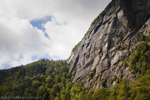
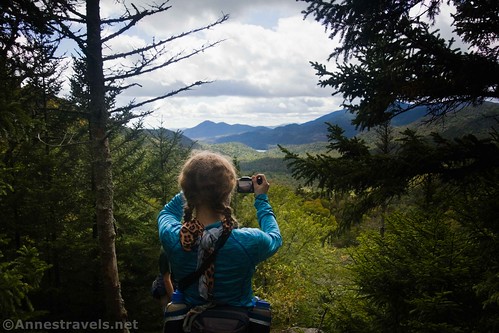
But for another, maybe even better, view, continue down the very steep social trail to a small viewpoint where you can see down toward Henderson Lake, Santanoni Peak, and more. It’s really quite impressive, especially with the colors on the trees just beginning to turn.

We ate lunch and then headed back down. We almost didn’t make it before dark… so I recommend an earlier start than we had if you want to hike up to Indian Pass. But it’s a great hike with a great view, and the rocks and ladders make it fun!

Round Trip Length: 10.5 miles (the GPS says that it’s only 9.3)
Elevation Gain: 2,146ft. (1,772ft. to 2,753ft.)
Facilities: None
Fees: None
Trail Notes: You’re probably going to get your shoes or boots muddy on this one. The scrambling up the rocks is Class 2 to Class 3 – I did get my least-dexterous hiking companion up and down it… and she hates heights. It’s probably best to hike this with a friend so you can give each other a push or pull if you or they need it.

Trail 
![]()
![]()
Road ![]()
Signs
Scenery ![]()
Would I go 100 miles out of my way for this? ![]()
Overall Rating: ![]()
GPS Coordinates for Indian Pass & Summit Rock
Upper Works Trailhead: 44.086820,-74.055991 (44°05.20920′, -074°03.35946′ / 44°05’12.5520″, -074°03’21.5676″) (1,764ft.) (0.0)
Real Trailhead (signboard): 44.089182,-74.056269 (44°05.35092′, -074°03.37614′ / 44°05’21.0552″, -074°03’22.5684″) (1,767ft.) (0.19)
Henderson Lake Junction: 44.092198,-74.058035 (44°05.53188′, -074°03.48210′ / 44°05’31.9128″, -074°03’28.9260″) (1,819ft.) (0.46)
Calamity Brook Trail Junction: 44.093856,-74.057130 (44°05.63136′, -074°03.42780′ / 44°05’37.8816″, -074°03’25.6680″) (1,833ft.) (0.60)
Duck Lake Junction: 44.108864,-74.060573 (44°06.53184′, -074°03.63438′ / 44°06’31.9104″, -074°03’38.0628″) (1,840ft.) (1.84)

Henderson Lean-to: 44.110752,-74.059569 (44°06.64512′, -074°03.57414′ / 44°06’38.7072″, -074°03’34.4484″) (1,846ft.) (2.01)
Calamity Brook Crossover Trail: 44.113683,-74.056132 (44°06.82098′, -074°03.36792′ / 44°06’49.2588″, -074°03’22.0752″) (1,895ft.) (2.42)
Wallface Lean-to: 44.121541,-74.053097 (44°07.29246′, -074°03.18582′ / 44°07’17.5476″, -074°03’11.1492″) (2,015ft.) (3.14)
Beaver Dam: 44.125524,-74.049315 (44°07.53144′, -074°02.95890′ / 44°07’31.8864″, -074°02’57.5340″) (2,041ft.) (3.62)
Social trail up Wallface Mountain (some call it the “Diagonal Approach”): 44.132206,-74.039410 (44°07.93236′, -074°02.36460′ / 44°07’55.9416″, -074°02’21.8760″) (2,227ft.) (4.48)

First ladder: 44.133727,-74.036381 (44°08.02362′, -074°02.18286′ / 44°08’01.4172″, -074°02’10.9716″) (2,421ft.) (4.91)
Third Ladder: 44.134883,-74.033583 (44°08.09298′, -074°02.01498′ / 44°08’05.5788″, -074°02’00.8988″) (2,663ft.) (5.19)
Summit Rock Junction: 44.135207,-74.033249 (44°08.11242′, -074°01.99494′ / 44°08’06.7452″, -074°01’59.6964″) (2,693ft.) (5.24)
Summit Rock: 44.135227,-74.033394 (44°08.11362′, -074°02.00364′ / 44°08’06.8172″, -074°02’00.2184″) (2,665ft.) (5.28)
Summit Rock/Indian Pass End: 44.086671,-74.055969 (44°05.20026′, -074°03.35814′ / 44°05’12.0156″, -074°03’21.4884″) (1,765ft.) (10.54)
The gpx file for Indian Pass and Summit Rock can be downloaded – please note that this and the GPS Coordinates are for reference only and should not be used as a sole resource when hiking this trail.
Download GPX File size: 188.8 KB Downloaded 517 times
(Note: I do my best to ensure that all downloads, the webpage, etc. are virus-free and accurate; however, I cannot be held responsible for any damage that might result, including but not limited to loss of data, damages to hardware, harm to users, from use of files, information, etc. from this website. Thanks!)

Getting to the Indian Pass/Summit Rock Trailhead
From Newcomb, New York, drive east on NY-28N E. After about 5 miles, turn left onto Blue Ridge Road for 1.2 miles. Turn left on Tahawus Road, following the brown sign with the yellow lettering pointing toward the High Peaks Wilderness. Drive 6.3 miles, then, just before the bridge over the Hudson River, turn left onto the Upper Works Road. The Upper Works Trailhead is at the end of the paved road, 3.4 miles later.

From I-87, take Exit 26 toward Minerva/Pottersville/NY-9. Turn left onto Stone Bridge Road for a half mile, then turn right onto US-9S for 0.6 miles. Turn right onto Olmstedville Road for 5 miles; continue straight for another mile on County Highway 29, then turn left to stay on County Road 29. After 0.4 miles, turn right onto AP Morse Highway for 2.9 miles. Turn right onto NY-28N W. After 13.8 miles, turn left onto Blue Ridge Road for 1.2 miles. Turn left on Tahawus Road, following the brown sign with the yellow lettering pointing toward the High Peaks Wilderness. Drive 6.3 miles, then, just before the bridge over the Hudson River, turn left onto the Upper Works Road. The Upper Works Trailhead is at the end of the paved road, 3.4 miles later.

This Week’s Featured Product!
With 46 spectacular hikes, this book is packed with trails to mountains, lakes, ponds, forests, rivers, and more.