

Biking the boardwalk at Turning Point Park, part of the Genesee Riverway Trail
A couple weeks ago, we took a bike ride along the Genesee Riverway in Rochester, New York. I had ridden the northern part of the Genesee Riverway from downtown Rochester to the Erie Canal in Genesee Valley Park a few years ago, and I had even done part of this trail last December (but never quite got around to blogging about it). The great thing about the trail is that there is so much to see along the way, and both ends (Ontario Beach Park and Maplewood Park) have quite a bit of excitement, so it’s worth doing the whole route, or at least driving to both ends.
Quick Stats

Charlotte Pier at Ontario Beach Park in December (see the ice?)
We started out at Ontario Beach Park (actually, we rode from near Sea Breeze through Durand Eastman Park and then took the Irondequoit Lakeside Trail to Ontario Beach Park, but that’s a topic for another post). Our first order of business was to bike out the length of the pier to the lighthouse at the end. In December, people gave us some real hard looks as we navigated our bicycles over the patches of ice on the pier, but we weren’t the only cyclists in April! There were several fishermen at the end of the pier, and we also saw mallard ducks and a long-tailed duck.

Long-tailed Duck in Lake Ontario
From there, we headed south along the Genesee River (funny, the Genesee Riverway Trail follows the Genesee!) It’s a little tricky, but if you take the sidewalk around the marina (follow the signs for the Genesee Riverway), you’re on the right track.
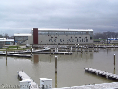
The Port of Rochester building from across the marina
Be sure to look up on the hill for the old Charlotte Lighthouse!

The historic Charlotte Lighthouse
Once around the marina, if you go across the gravel parking area at the top of the hill toward the river, you can get to a little platform with a sign about the history of the Hojack Line that once crossed the Genesee River here via a swinging bridge. The last train crossed the bridge in 1978, the bridge was decommissioned in 1995, and it was removed in 2013 to make way for the ferry between Rochester and Toronto (which was a failed effort, but we won’t go into the politics here). This is the same Hojack Line that used to cross the outlet of Irondeqoit Bay and is now a rails-to-trails in Webster.

Out on the viewpoint marking the old Iron Hojack line
Continue up the Genesee River – you’ll pass a few restaurants, then be on river-level on a wooden platform beside the river. You should be about 2.0 miles at this point. Take the wooden planks upriver toward the drawbridge and you can’t miss the trail (use caution on the wooden decking – I believe there are signs about walking your bicycle until you get back on the pavement, but I think that’s for the safety of pedestrians).

Heading for the drawbridge. You’re really on the Genesee Riverway Trail at this point.
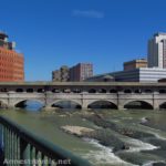
Pass under the drawbridge (another outcome of the ferry between Rochester and Toronto) and continue upriver. The path passes by a slightly seedier marina and climbs – and climbs – and climbs – to the top of the hill. It seemed perfectly safe, but the number of signs with location and 911 on them made me wonder just how secure this section of the trail is (I was with a large group, so I wasn’t too worried).

Approaching the north end of the boardwalk in Turning Point Park
The trail descends quickly onto the boardwalk in Turning Point Park about 1.3 miles from the wooden decking. Honestly, this is the crowning glory of the entire trail. At 2/3 of a mile of just boardwalk, it’s won awards for its construction.
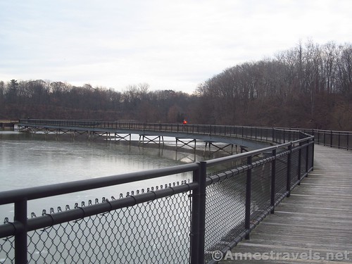
Boardwalk at Turning Point Park
The “Turning Point” was the wide spot in the river where large ships, coming up to the Port of Rochester from Lake Ontario, would turn around after unloading their cargo so they could motor back out to the lake. Very few large ships come up the Genesee anymore (I believe only one dock is still active, and that one is one owned by a cement company – more on that later). So now the boardwalk circles the “turning point”, allowing walkers, cyclists, joggers, photographers, and those with fishing poles an opportunity to walk, bike, jog, see birds and other wildlife, and fish (you probably have to have a license to fish; check it out before you go).
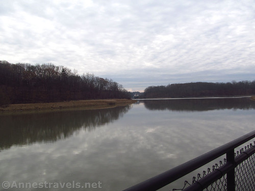
Wither reflections at Turning Point Park
Several members of my group saw wood ducks; we all saw hawks and mallard ducks; and we also all saw my favorite: mute swans building a nest almost right next to the boardwalk!
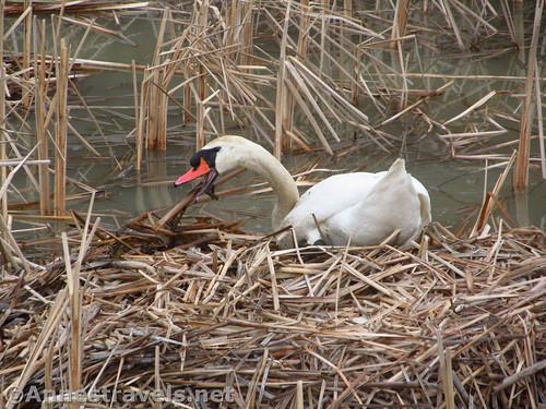
Open-mouthed swan building its nest near the boardwalk. You might see an egg in the nest; I’m not sure.
There are also a couple old pillars that are good for fishing or hanging out ‘way out in the river.

One of the swans out in the open water
At the end of the boardwalk (about mile 3.75) is a three-way junction. The far right will take you up to the parking area; the middle trail is a higher trail that will take you out in the same place as the lower trail; and the left trail is the lower trail. We opted to go left and were very glad we did.

The McKeil Spirit, a laker from Hamilton, Ontario, unloading cement at the last active dock along the north end of the Genesee River
On our visit in December, I hadn’t planned on going south of the boardwalk, but we could see a huge ship up by the one active dock on this part of the Genesee River, unloading cement via green pipes that sucked the contents up to the cement factory high above the trail. So the lower trail was a no-brainer. We rode down to where we could see the laker from a safe distance, then (probably unwisely) inched out on a rotting, rusting dock to get a better look (and better pictures!)
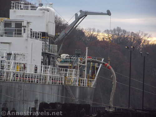
Unloading cement. It looks like evening, but it was actually about noon. That’s December in Rochester, lol.
It was really cool for those of us with relatives who used to sail the lakers (pre-WWII) and who have seen similar boats go through the locks on various canals between the Great Lakes.
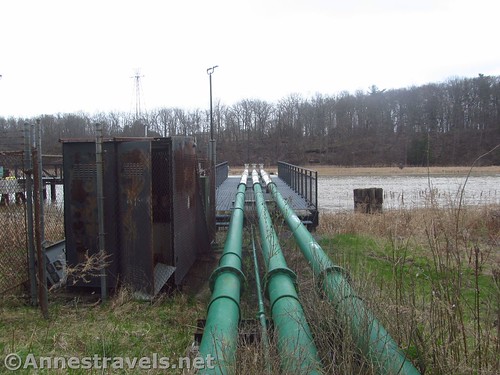
The pipes used for unloading cement
We took the lower trail again in April to show the rest of the group where the ship had been. Right about where we had stopped, about 0.1 miles beyond the junction at the end of the boardwalk, we found another junction with the paved path going uphill to the right and a second gravel road going off to the left along the Genesee. With no ship to get us into trouble by trespassing, and since there weren’t any signs saying we couldn’t, we went left.
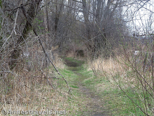
The trail gets more rustic once you’re past the active dock
It’s a pretty rugged gravel path, but it is interesting. We passed by many old docks, the dock used by the cement company, and then entered a wetland with an even more rugged single-track path that looked at times as though it was carpeted with coal or cinders (at one time, coal from Pennsylvania was transported by rail up to this port, then shipped over to Canada). With more old dock parts next to the river, the trail finally ended (very officially) at a small turn-around on the edge of the wetland.
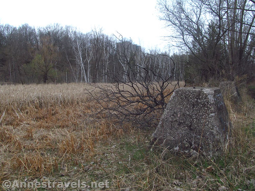
The wetland near the end of the rustic path
It was pretty and secluded down there, but we knew the drivers of our vans were waiting for us somewhere to the south, so we retraced our steps back to the paved path. In total, the more rugged path was about 0.7 miles (RT) out of our way.

Parts of old docks
The trail goes steeply uphill (you’ll be on the edge of a gorge before all this is done, so it makes sense you’ll have to go uphill) and under the green pipes used by the cement company.

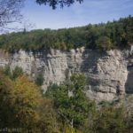
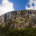
“Brown Falls” or Turning Point Falls (south – the north “Red Falls” is visible from the Turning Point boardwalk)
There is a small waterfall on the top of the hill about mile 3.8. It’s worth a short trek off the path to see.

Along Lake Avenue – the sidewalk for walkers (left) and bikers (right) – note the biker on the left (facepalm)
A quarter mile beyond the waterfall, the path meets up with the upper path. Turn left to continue south. The Genesee Riverway Path ends at Lake Avenue next to the Riverside Cemetery (which seems to go on forever!) about mile 4.4. Turn left here – there is a sidewalk dedicated to bicycle traffic (yay!)

Castle-like entry to Riverside Cemetary along Lake Avenue
Keep going beside the cemetery and don’t cross Lake Avenue. A brick building will appear in front of you (sounds sort of ethereal, but it’s very real). From here, you have two options to get to Maplewood Park: 1) you can continue on Lake Avenue then turn left on Maplewood Drive to pick up the path or 2) you can do what we did and try to follow the trail. For the second option, turn left along the north side of the parking lot beside the brick buildings, find the path that goes off behind the buildings down the hill to a sort of meditative pond, then back up the hill. Once we found it, it wasn’t hard to follow, though it dumped us back on Lake Avenue almost as soon as you crested the top of the hill again – a lot of up and down hill only to get back to the road. Continue on Lake Avenue, then turn left on Maplewood Drive and pick up the path again about mile 5.75.

The “trail” such as it is behind the brick building
Follow the path-that-looks-like-a-sidewalk a bit (don’t follow the steeply downhill road that says something about authorized vehicles only!), then turn left at the trail junction (the one with the gate across it across the road from the parking area for Maplewood Park, not the one that is sort of like a circle up to a viewing platform – though I hear the views are pretty good from up there) about mile 6.4. The trail will go very much downhill and slightly back the way you just came.

The rampway down (or back up) to the pedestrian bridge over the Genesee River Gorge
This was exhilarating, to say the least, on a bicycle! At the bottom of the slope, the path turns sharply to cross the Genesee River Gorge via a massive bridge. Wow!

The pedestrian bridge is quite wide – so even though the drop is far, it’s not too frightening
Several of us took the ramp up the other side of the bridge to Seneca Park just so we could ride back down (oh, wait, that was so the GPX could be complete all the way to Seneca Park at mile 6.75, right?) The views here were pretty good on a pre-spring day under cloudy skies. On a sunny day with the fall colors, this view would be spectacular!

Veterans Bridge from the pedestrian bridge
In total, we rode about 7 miles from Ontario Beach Park, out the Charlotte Pier, then back down the Genesee Riverway, taking the lower trail and the rugged trail, then continuing on the Genesee Riverway to Maplewood Park, up the other side of the gorge to Seneca Park, and then back across the gorge to Maplewood Park. It was a nice ride, and I highly recommend it on a sunnier day than I had!

The emblem used at times to mark the Genesee Riverway Trail (or Genesee River Trail)
Trail Length: About 7 miles as a shuttle
Vertical Elevation Change: 167ft. (220ft. to 387ft.)
Facilities: Restrooms at Ontario Beach Park (even if the restrooms are closed, there are restrooms in the Port of Rochester building); a bike station with an air pump and various bike tools at Ontario Beach Park (near the Port of Rochester building); food and concessions in the Port of Rochester Building and in the general area – I hear some of the little pubs are good, but most were closed in December and in April.
Fees: None
Trail Notes: This trail does go through some areas that may or may not be as secure as most trails I write about. I wouldn’t recommend walking this trail alone. There is a lot of history along the trail and many signs about said history. The historic carousel at Ontario Beach is open in the summer and charges about $1/ride/person. There is also swimming at the beach in the summer, but I’ve never done it, so I’m not familiar with the regulations. No pets are allowed in Ontario Beach Park. Seneca Park does have a zoo ($7-$12/person) and several playgrounds. You can take the Olmstead Trail north from the end of the pedestrian bridge for quite a distance.

The pier and lighthouse at Charlotte from Ontario Beach Park
Trail 
![]()
Road ![]()
Signs ![]()
![]()
Scenery ![]()
![]()
Would I go 100 miles out of my way for this? ![]()
![]()
Overall Rating: 
![]()

The historic Charlotte Lighthouse up on the hill above the Port of Rochester
GPS Coordinates for the Genesee Riverway
Note: The GPS Coordinates are correct, but the mileages are pretty widely varying, in part because they came from two different rides – one in April and one in December. Take the mileages with a “grain of salt”.

The “frog” in the railroad track (where the two tracks come together) near the drawbridge in Charlotte
Arrive at Genesee Riverway (near the drawbridge): 43.2494333°, -077.6119833° (N43° 14.966′ W77° 36.719′ / 43°14’57.9600″, -077°36’43.1400″ ) (266ft.) (8.73ft.)
It’s 1.4 from where we met the Riverway to the end of the pier in Ontario Beach Park; we biked out to the end of the pier, then back to the drawbridge, but this is not reflected in the mileages.
South end of Turning Point Bridge: 43.2301000°, -077.6166667° (N43° 13.806′ W77° 37.000′ / 43°13’48.3600″, -077°36’60.0000″) (234ft.) (10.9)
Top of waterfall view: 43.2240500°, -077.6178000° (N43° 13.443′ W77° 37.068′ / 43°13’26.5800″, -077°37’04.0800″) (292ft.) (12.0)
Trail Junction: 43.2224000°, -077.6191500° (N43° 13.344′ W77° 37.149′ / 43°13’20.6400″, -077°37’08.9400″) (320ft.) (12.2)
Lake Avenue: 43.2197833°, -077.6286500° (N43° 13.187′ W77° 37.719′ / 43°13’11.2200″, -077°37’43.1400″) (380ft.) (12.78)
Beginning of Sidewalk: 43.1951333°, -077.6214500° (N43° 11.708′ W77° 37.287′ / 43°11’42.4800″, -077°37’17.2200″) (387ft.) (14.8)
Pedestrian Bridge over the Genesee Gorge: 43.1978833°, -077.6206000° (N43° 11.873′ W77° 37.236′ / 43°11’52.3800″, -077°37’14.1600″) (333ft.) (15.08)
End of bridge / walkway at Seneca Park: 43.2011167°, -077.6215500° (N43° 12.067′ W77° 37.293′ / 43°12’04.0200″, -077°37’17.5800″) (382ft.) (15.39)
End in Maplewood Park: 43.1950333°, -077.6219500° (N43° 11.702′ W77° 37.317′ / 43°11’42.1200″, -077°37’19.0200″) (381ft.) (16.0)

The pedestrian bridge, as seen from the ramp down from Seneca Park
These are the coordinates from December – we had come down the Ontario Parkway Trail before arriving at the Iron Hojack Bridge Area.
Iron Hojack Bridge Area: 43.2535667°, -077.6085833° (N43° 15.214′ W77° 36.515′ / 43°15’12.8400″, -077°36’30.9000″) (268ft.) (3.84)
Ontario Beach Park Parking Area: 43.257307, -77.607237 (43°15.43842′, -077°36.43422′ / 43°15’26.3052″, -077°36’26.0532″)
End of Charlotte Pier: 43.2638833°, -077.5990000° (N43° 15.833′ W77° 35.940′ / 43°15’49.9800″, -077°35’56.4000″) (258ft.) (4.97)
Turning Point Park (north end): 43.2313667°, -077.6178167° (N43° 13.882′ W77° 37.069′ / 43°13’52.9200″, -077°37’04.1400″) (258ft.) (7.8)
Turning Point Park (south end; maybe a bit further south): 43.2282167°, -077.6168833° (N43° 13.693′ W77° 37.013′ / 43°13’41.5800″, -077°37’00.7800″) (258ft.) (8.11)

Swan building its nest at Turning Point Park in Rochester, New York
The gpx file for the Genesee Riverway can be downloaded – please note that this and the GPS Coordinates are for reference only and should not be used as a sole resource when hiking or biking this trail. Also note that this GPX includes my trek on the Irondequoit Lakeside Trail from Sea Breeze through Durand Eastman Park and then down the Riverway, but it does not include going out to the Charlotte Pier (our communication lines got crossed, so we did it, but I didn’t record it on my GPS – though I did record distances, etc., on the trek out to the pier in December).
Download GPX File size: 77.9 KB Downloaded 382 times

Looking down on the Genesee Riverway Trail and toward the Port of Rochester from the drawbridge in Charlotte
You can also download the gpx file for my ride on the Ontario Parkway Trail, then out to the Charlotte Pier, then down to Turning Point Park, then back up the Genesee Riverway, and lastly east on the Irondeqoit Lakeside Trail to Sea Breeze.
Download GPX File size: 0.0 B Downloaded 0 times
(Note: I do my best to ensure that all downloads, the webpage, etc. are virus-free and accurate; however, I cannot be held responsible for any damage that might result, including but not limited to loss of data, damages to hardware, harm to users, from use of files, information, etc. from this website. Thanks!)

Icicles on the Charlotte Pier in December
Getting to the Genesee Riverway
Directions to Ontario Beach Park (43.257307, -77.607237)
From the west: Take Rt-390 north to Exit 27A toward Ontario Parkway East toward Rochester (or that’s what the sign says). After 3 miles, turn left onto Lake Avenue (if you cross the drawbridge over the Genesee River, you’ve gone too far). Drive 0.6 miles, then turn right onto Corrigan Street; take an almost immediate left into the parking area for the Port of Rochester and Ontario Beach Park.

Coast guard building and boat, across the river from the Charlotte Pier
From the east: From Seabreeze, wiggle your way around the traffic circles to Durand Blvd. Turn west onto Durand Blvd and continue straight when the road enters Durand Eastman Park and changes names to Sweet Fern Road. Continue to continue straight for 4.1 miles (you’ll pass through Durand Eastman Park which was very nice but I hear is overcrowded in the summer with picnickers). At the traffic light, turn right on St. Paul Blvd, then take a quick left onto Pattonwood Drive (before you get to the train bridge). After 0.9 miles, shortly after crossing the drawbridge, turn right onto Lake Avenue. Drive 0.6 miles, then turn right onto Corrigan Street; take an almost immediate left into the parking area for the Port of Rochester and Ontario Beach Park.

The top of the historic Charlotte Lighthouse – and the weather vein!
From the south: You have three choices: take Rt. 390 (as described in “From the west”), take Rt. 590 north to Seabreeze (as described in “From the east”), or take Lake Avenue north all the way to Ontario Beach Park.

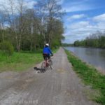
Riding out onto the Charlotte Pier in April
Directions to Maplewood Park 43.1950333°, -077.6219500°:
From Ontario Beach Park: Exit the parking area by turning right, then turn left immediately onto Lake Avenue. After 4.0 miles, turn left onto Maplewood Drive for 0.4 miles. Continue straight (left) onto Bridge View Drive for 0.2 miles to the parking area, on right.

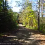
An average photo of the Genesee Riverway Trail
From Rt. 104 Westbound (going into the old Kodak area): Just after crossing the bridge over the Genesee River Gorge, take the exit on the right to Maplewood Drive. After 0.1 miles, turn right onto Bridge View Drive (first right); drive 0.2 miles to the parking area, on right.

Paddle steamer at the Port of Rochester
From Rt. 104 Eastbound (just after exiting the old Kodak area): Turn left on Lake Avenue. After 0.5 miles, turn right onto Maplewood Drive for 0.4 miles. Continue straight (left) onto Bridge View Drive for 0.2 miles to the parking area, on right.

Visual trail map and elevation profile for my trek along the Irondequoit Lakeside Trail and the Genesee Riverway (April edition – which is missing the ride out the Charlotte Pier, but goes all the way to Maplewood Park and Seneca Park)

Visual trail map and elevation profile for my bike ride on the Ontario Parkway Trail, the Genesee Riverway Trail (to the Charlotte Pier and Turning Point Park), then on the Irondequoit Lakeside Trail
Zoom map out to browse nearby hikes & places of interest
This Week’s Featured Product!
Looking for more bike rides? This book features many rails-to-trails in New Jersey, New York, and Pennsylvania, including a remarkable number in western New York State.

Pingback: Permission to Fail - Anne's Travels