

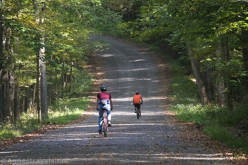
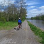
A few years ago, a couple of us were riding our bicycles on the Genesee Valley Greenway through Letchworth State Park. As a side-trek, we ended up on the Big Bend Road in the state park. It was fun, so we decided to go back and finish off the road and see what there was to see along the way. It was a little bit disappointing (more on that later) but it was a nice, quiet bike ride. The leaves were just beginning to change color, which made it a pretty ride.
Quick Stats
Note: Some of the links in this post are affiliate links. If you click one and purchase something, I may earn a small commission without an extra cost to you.
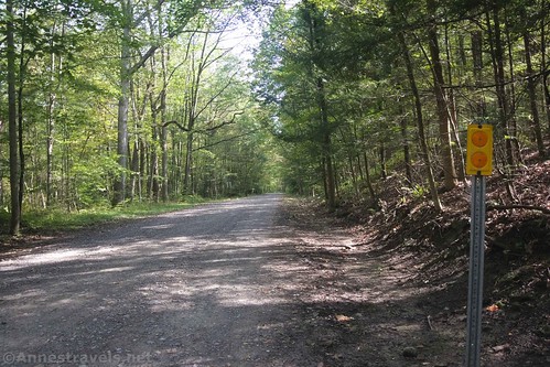
We could have technically driven the van the entire way up the road. We saw several trucks do it and a couple of SUVs. Low clearance is not recommended; Big Bend is a gravel road that is sometimes rough and a little bit washed out. (I do think we did it in our 1989 Chevy Station Wagon at one point, but that was quite a while ago.) But we decided that biking would be more fun. After all, it was a beautiful autumn day and the views promised to be good.
We started out at the old Parade Grounds in Letchworth State Park. The Parade Grounds were first used during the American Civil War, then again for the CCCs, then again for German POWs during WWII (though you’ll rarely hear about them in the official history displays). Now it’s a large parking area with a picnic shelter and grassy areas for playing. We parked, pulled out our bikes, and started off down the park road.
Down describes it pretty well – there’s almost not a single uphill for the next 1.3 miles!
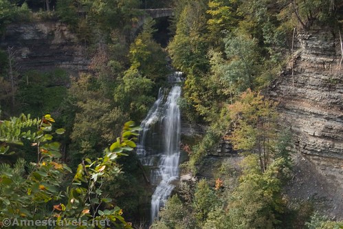
Fairly quickly (like 0.2 miles) after leaving the parking area, you’ll cross the Genesee Valley Greenway. I highly recommend turning left (west) here and taking the fairly smooth (if sometimes muddy) and flat trail to viewpoints of Letchworth Gorge, Middle Falls, and parts of the old Genesee Valley Canal. We did that on our way back – it’s a very worthwhile side-trek.
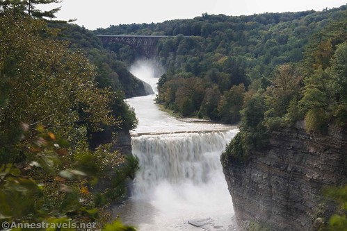
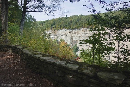
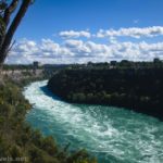
Continuing downhill on the road, you’ll pass by an obvious viewpoint on the left 0.2 miles later. This offers views of the gorge above the Lower Falls.

The road finally comes to an uphill 1.3 miles from the parking area. It rolls over another hill before hitting another low point at 2.4 miles – which is also the turnoff for the cabins. Continue straight on the Big Bend Road.
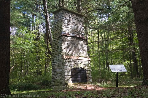
Actually, a short distance up the road, the loop from the cabins returns. If you want another interesting side-trek, you can turn right here for a short distance to the remains of Camp 23, SP5 and Big Bend Chimney. The cabin area once housed the Civilian Conservation Corps (CCCs), dedicated in June of 1933. The camp was named the top CCC camp in the region and included at least twenty buildings. The stone chimney from the Recreation Building was restored in 2018. We took the side-trip on our return.
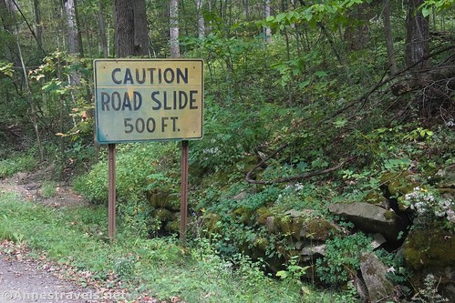
After the cabins, the Big Bend Road decides it doesn’t like going downhill and is a steep and relentless uphill for the remainder of the two-way section of the road. The road also becomes rougher – the road is accessible to low clearance vehicles up to the cabins. It didn’t bother me on my bicycle, but I could see where a low-clearance vehicle or a none-too-powerful engine might have trouble.

The road finally stops climbing about the time it comes to a road split at mile 4.1. It’s one-way from here as a loop around the end of the bluff. Turn right.

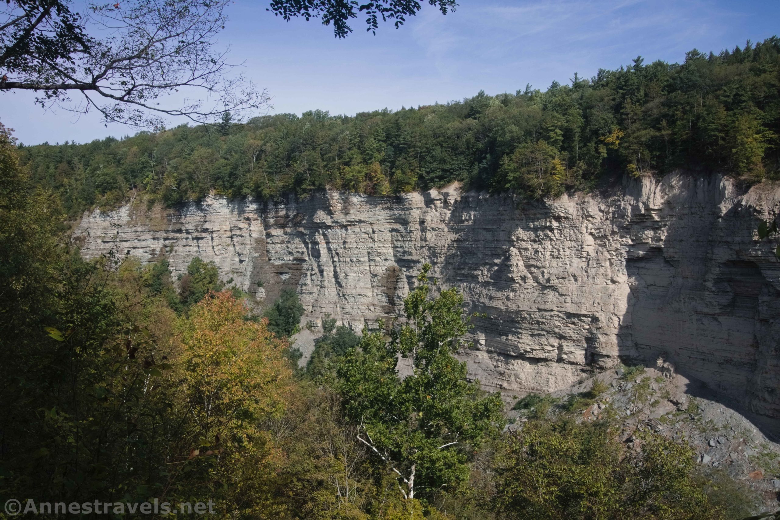
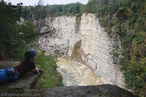
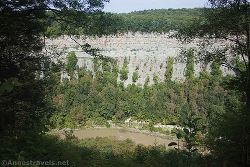
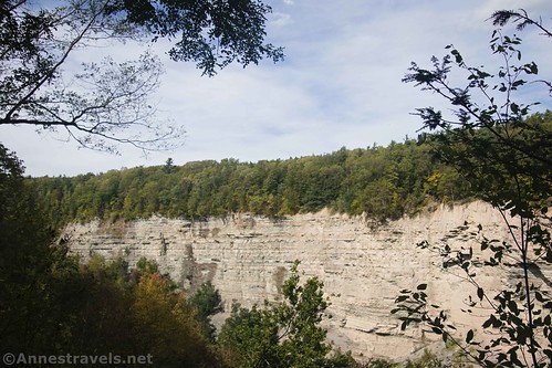
At 0.4 miles later, you’ll come to the reason (obviously!) that you’ve just biked up that hill: The one and only overlook on the Big Bend Road. I won’t call it stunning, but it does give you a nice view of a sheer cliff on the opposite side of the gorge.
Continue along the road as it winds in a loop back to the road split. This is the “Big Bend” – where the Genesee River winds in a gooseneck around the bluff you’re riding on. About halfway around, the gentle uphill becomes a gentle downhill. We stopped along the way and bushwacked over to a bench to eat lunch with a peek-a-boo view down on Letchworth Gorge.

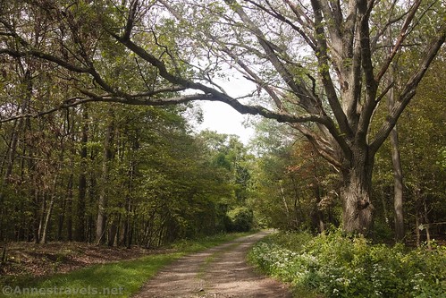
On the way back to the road split, I found this beautiful old oak. The lighting was just right for a photo.
There is also a road that leads to an old camping area – but it has all kinds of signs about staying out. I can’t tell from Google Maps what it’s used for – it looks like an open, gravely field. Who knows?

Return to the parking area via the Big Bend Road. Remember, it’s all downhill to the cabins and all uphill to the Parade Grounds!
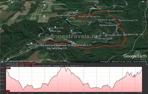
Total Trail Length: I went 11.2 miles including a side-trip to the Big Bend Chimney and the west end of the Greenway Trail on the way back. Without those two side-trips, the road is about 9.2 miles out & back from the Parade Grounds.
Elevation Gain: 1,826ft. (7,90ft. to 1,239ft.)
Facilities: Restrooms, picnic facilities, and playground at the Parade Grounds. Otherwise, none on the Big Bend Road.
Fees: $10/vehicle May 7-October 24 between 9am and 5pm. However, it’s been a long time (never?) since I’ve seen anyone collecting fees on this side of the gorge.
Trail Notes: The road makes this a fairly easy bike ride except for the elevation gain (which is killer!) There aren’t tons of views along the route, so go when the autumn colors are coming out or when most of the leaves are off of the trees. I would imagine the cabin area could be busy on summer weekends.

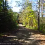
Trail 
![]()
Road ![]()
Signs ![]()
![]()
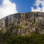
Scenery ![]()
![]()
Would I go 100 miles out of my way for this? ![]()
![]()
![]()
Overall Rating: ![]()
![]()
GPS Coordinates for the Big Bend Road
Trailhead (Parade Grounds): 42.583480,-78.031924 (42°35.00880′, -078°01.91544′ / 42°35’00.5280″, -078°01’54.9264″) (1,192ft.) (0.0)
Lower Falls Viewpoint: 42.584684,-78.026219 (42°35.08104′, -078°01.57314′ / 42°35’04.8624″, -078°01’34.3884″) (1,032ft.) (0.37)
Trail 8a: 42.591072,-78.002374 (42°35.46432′, -078°00.14244′ / 42°35’27.8592″, -078°00’08.5464″) (861ft.) (1.96)
Cabins: 42.597312,-78.002367 (42°35.83872′, -078°00.14202′ / 42°35’50.3232″, -078°00’08.5212″) (799ft.) (2.40)
Trail 10: 42.601175,-78.002947 (42°36.07050′, -078°00.17682′ / 42°36’04.2300″, -078°00’10.6092″) (816ft.) (2.68)
Trail 10a: 42.609035,-78.004493 (42°36.54210′, -078°00.26958′ / 42°36’32.5260″, -078°00’16.1748″) (920ft.) (3.28)
Road split (begin one-way loop): 42.603385,-78.016722 (42°36.20310′, -078°01.00332′ / 42°36’12.1860″, -078°01’00.1992″) (1,118ft.) (4.11)
Big Bend Overlook: 42.603408,-78.024465 (42°36.20448′, -078°01.46790′ / 42°36’12.2688″, -078°01’28.0740″) (1,208ft.) (4.55)
Return to the Road Split: 42.603360,-78.016671 (42°36.20160′, -078°01.00026′ / 42°36’12.0960″, -078°01’00.0156″) (1,117ft.) (5.43)

Big Bend Chimney: 42.600705,-78.000768 (42°36.04230′, -078°00.04608′ / 42°36’02.5380″, -078°00’02.7648″) (824ft.) (7.07)
Greenway Turnoff: 42.584915, -78.030522 (42°35.09490′, -078°01.83132′ / 42°35’05.6940″, -078°01’49.8792″) (1,139ft.) (9.87)
End of the Greenway: 42.584716, -78.038880 (42°35.08296′, -078°02.33280′ / 42°35’04.9776″, -078°02’19.9680″) (1,090ft.)
End (including side-trek to chimney and the Greenway): 42.583505,-78.031819 (42°35.01030′, -078°01.90914′ / 42°35’00.6180″, -078°01’54.5484″) (1,190ft.) (11.17)

The gpx file for my ride on the Big Bend Road can be downloaded – please note that this and the GPS Coordinates are for reference only and should not be used as a sole resource when hiking this trail.
Download GPX File size: 37.0 KB Downloaded 473 times
(Note: I do my best to ensure that all downloads, the webpage, etc. are virus-free and accurate; however, I cannot be held responsible for any damage that might result, including but not limited to loss of data, damages to hardware, harm to users, from use of files, information, etc. from this website. Thanks!)
Getting to the Parade Ground/Big Bend Road
From I-90 east of Buffalo, take Exit 48A for NY 77 toward Pembroke and Medina. After exiting, turn right onto NY-77S for 7.2 miles. Turn left onto Hwy 20E for 1.9 miles, then right onto NY-238S for 4.2 miles. Take a right onto Market Street for 0.3 miles, then turn left onto NY-238S for another 10.7 miles. When NY-238S crosses US-20A, the road changes name to Hermitage Road; continue straight another 6.6 miles. Turn left on NY-78S for a quarter mile, right on Hardys Road for 5.2 miles, and then left on NY-39E for 2.1 miles (at which point the road changes names to Griffith Road) continue straight another 4.7 miles. A sign here will point left toward Letchworth State Park. Continue straight 0.3 miles and turn left on NY-436E for 1.4 miles (go through the town and cross the Genesee River). Just after passing under the train bridge, turn left onto the paved road beside the brown sign proclaiming Letchworth State Park. The Parade Grounds will be on the left after 0.5 miles.
From I-90 west of Syracuse, drive south on I-390 to Exit 7, signed for Letchworth Park (a salt mine can be seen on the east side of the road just before the exit – the rail service that takes the salt to market is called the “Genesee and Wyoming Railroad” and has often won the “safest railroad in North America” award, despite the fact that they now own hundreds of other small railroads around the world). At the bottom of the ramp, turn left on NY-408S 1.9 miles into the town of Mount Morris (if you need supplies, this is the place to stock up). Turn left on Main Street, then take a quick right on NY-408 and drive 7.6 miles. Just before driving down the hill into Nunda (pronounced nun-DAY), take a right onto Short Tract Road. After 3.5 miles, turn left onto Oakland Road for 2.1 miles, then turn right on Short Tract Road for 1.7 miles. At this point, you should see big blue silos across the road. Turn right on NY-436W for 2.1 miles. Turn right on the paved road beside the brown sign marking Letchworth State Park. The Parade Grounds will be on the left after 0.5 miles.

From I-86, take Exit 31 toward Peacock Hill Road. Turn left on Peacock Hill Road for 0.4 miles; turn left on E Main Street for 0.2 miles, and take the 2nd exit in the traffic circle to stay on Main Street another 0.6 miles. Turn right on Peavy Road and after only 0.1 miles, take a slight left to stay on Peavy Road another 0.9 miles. Turn right onto County Road 15 for 14.2 miles, then continue straight on Short Tract Road for 0.8 miles. Turn left onto NY-436E for 1.8 miles. Turn right on the paved road beside the brown sign marking Letchworth State Park. The Parade Grounds will be on the left after 0.5 miles.
From Portageville (NY-19A), turn onto NY-436E for 1.4 miles (go through the town and cross the Genesee River). Just after passing under the train bridge, turn left onto the paved road beside the brown sign proclaiming Letchworth State Park. The Parade Grounds will be on the left after 0.5 miles.
This Week’s Featured Product!
This is one of the best books I’ve found for adventures in western New York. It features 200 waterfalls – from short strolls to long bushwacks.
More Related Posts:
 Genesee Valley Greenway – Oakland to Letchworth
 Beautiful Keuka Outlet Trail!
 Genesee Riverway – Ontario Beach Park, Turning Point Park, & Maplewood Park
 Fun Hike to Indian Pass & Summit Rock
 Erie Canal: Meridian Center (Rochester) to San Souci Park (Brockport)
 Devils Hole, Whirlpool, and Niagara Gorge Railroad Grade