
How about a peaceful bike ride on an old railroad bed? What about one that also follows an old canal, complete with crumbling locks? And then how about that same rails-to-trails ending you up in one of the most scenic state parks in New York? If it sounds too good to be true, the Genesee Valley Greenway between Oakland Road (near Nunda, pronounced nun-DAY) and Letchworth State Park really does deliver it all, especially on a sunny fall day when the mosquitos have left for the season and the leaves are beginning to change color. Once we got to Letchworth, we took several trails to scenic viewpoints, so I’ll detail our entire ride here!
Quick Stats
(Affiliate links are present on this page.)
We’ve ridden part of the Genesee Valley Greenway before, from Mt. Morris to the Brookdale Preserve south of Rochester. This is the same trail, only much of the path between Mt. Morris and Nunda is not open to bicycles (which means you’d have to ride roads to connect the two). As you’ll see, this section doesn’t go on forever, either; between the section between the Middle Falls View and the town of Portageville is closed to hikers and bicycles alike.

We started our ride at the Oakland Locks Parking Area. There’s space for about four cars in what looks like an old driveway. Up the hill is a new wooden building that is part of the park, probably a facilities building of some sort. The first of the locks along the trail is within sight.

A sign will point toward the trail, but if you’re just looking for a pleasant ride (and not the locks), head up the road to where the railroad grade goes into the woods on the left. I came back that way, and it’s a much easier way to go then by the locks. But because I did go out by way of the locks, we might as well go out that way, too.
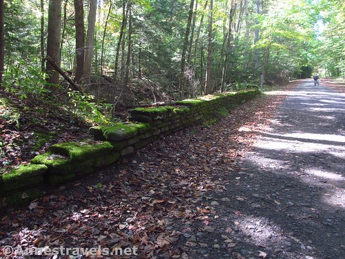
The trail starts up by the wooden building and passes above and to the right of the first lock. There are a total of three (or was it four?) locks in this section, all stone structures with dirt up against the stonework. Water still collects at the bottom of the locks, which were part of the “Seventeen Locks” of the Genesee Valley Canal that carried boats from Nunda over the hill to Portageville (so named, I’m going to guess, because boats had to portage around the waterfalls in Letchworth gorge!)

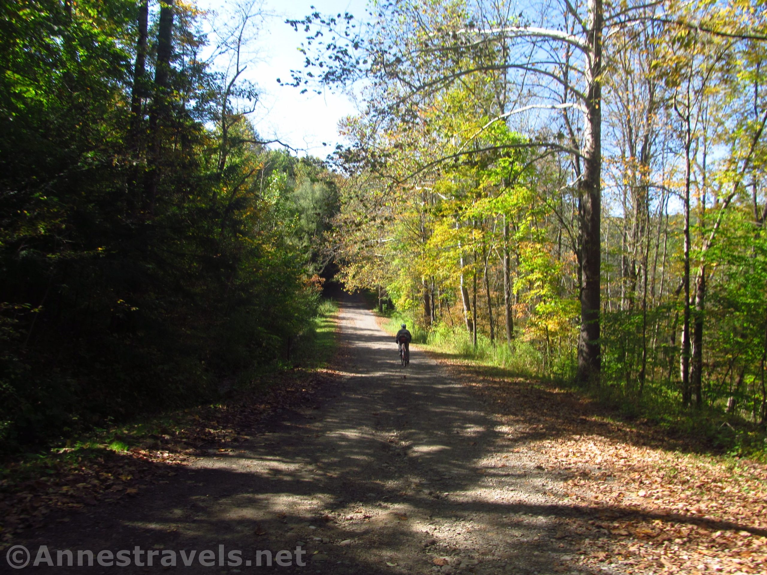
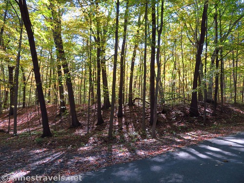
The one problem with biking this section of trail is that it’s steep uphill to the top of each lock, steep downhill down off the lock, and ditto for each lock. So it’s rough going. Then, suddenly, there’s a steep uphill to the right, and you’re up on the railroad grade. It’s much nicer for riding until you get close to Short Track Road (more hills). So as you can see, this part was not my favorite for biking, though it would have been fine for hiking. Cross over Short Track Road about mile 1.0 and ride down the dirt road (follow the signs for the Genesee Valley Greenway). Volunteers are working on clearing the next section of the railroad bed, but it’s not complete yet.

After just less than a half mile, watch for yellow gates on both sides of the dirt road. Turn right to go behind the gate and continue on the old railroad grade. (You could turn left a short distance until you run into the place where clearing of the trail has stopped – I did it – but on a bicycle, you’re not going to push through all those bushes).

Along most of this stretch of the trail, you’ll follow the remains of the Genesee Valley Canal as well as the railroad grade from the Pennsylvania Railroad (Rochester Branch). The fun thing for me is that my grandmother used to ride this very rail line to school. You’ll cross another dirt road before arriving at a paved road, aka the road on the east side of Letchworth State Park. From here, you have a number of choices, but we kept going straight. Signs say that the area ahead is closed, and they’re right, it is closed. But don’t give up; keep going straight nearly along the edge of the gorge. (The path is sandwiched between the ditch of the old canal and the edge of the gorge – though I had no qualms riding my bike on it, since the path is fairly wide and there are trees between you and the edge).

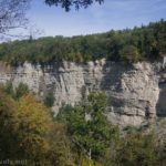
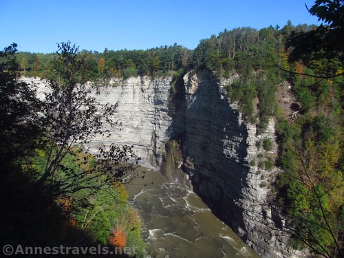
After not quite 0.7 miles, the trail ends in a brushy place with signs telling you the trail is closed. Turn right on the social-looking path that heads for the edge of the gorge. A short distance later, you’ll come to another sign saying that the area behind the sign is closed. Without having to go beyond the sign, you can stand on the edge of the cliff and get a great view of Middle Falls.

This view is probably not the best for those with vertigo, but it’s still a great view. You can also see a little bit of the Upper Falls and the trestle over the gorge.

Retrace your steps to the first “trail closed” sign. The area beyond this collapsed into the gorge in the late 1970s – my biking companion lived in the area at the time and remembers vividly when it happened. Before the signs were put up, he also took the social trails around the landslide area to where the path picks up again near the trestle. He found it quite an easy hike then, and today you can see the social trails that the locals only hint at. But there was no way we were going to try it on bicycles, and I’m not one for disregarding signs. Beyond all that, the other end (between the trestle and Portageville) is currently closed due to the trestle construction. So we retraced our steps to the Letchworth Park Road, then we turned right up to the Parade Grounds.

The Parade Grounds are so named because that’s exactly what they were used for during the American Civil War. Later, CCC barracks were built on the open space, then, when WWII began, the barracks were used as a POW camp. According to my biking companion, who wrote the local history of the area in the 1970s and spoke with many first-hand sources, the POWs built much of the stonework and trails in Letchworth – and if you go to northern Germany, you’ll see very similar stonework here and there.
We used the restrooms and then biked down the road to where Trail #6 goes into the forest. We did bike the trail; it’s a bit rough, but it’s mostly bikable except for the stairs. Trail #6 (Portage Trail) was one of the first trails constructed in the park (“They needed to have some way to get down to the Promenade on the other side of the river to get to the dances,” I said) and today it’s definitely not the most popular (though it’s quite popular by eastern Letchworth standards). But I found it quite pleasant – probably because there were nearly constant peek-a-boo views of the gorge (much more impressive from the east side than the west side of the gorge) and views down on the Lower Falls. The whole area had a feeling of having been once well-used and now mostly forgotten. Not in a bad way; more in the way of pleasant memories than being forbidding.

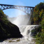
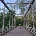
We skidded down to where the trail went down to the bridge across the gorge below the Lower Falls. The bridge is well worth crossing if you’re in the area, and it’s not a difficult jaunt from there to the more-official viewpoint for the Lower Falls (see my visit to the Lower Falls here). But since the bridge is currently closed (it looks like for restoration), we didn’t get too close.

We scrambled back up and took the trail up to the road (which is now gravel). But we had a little extra time on our hands, so we turned left to bike the road. On a sunny autumn day with the leaves just beginning to change, the road is a lovely bike ride (there’s almost no traffic at this time of year). We got as far as the cabins before we had to head back due to time restraints (but I would have liked to have biked another 2 miles out to the Big Bend viewpoint – so I did it the next year).

Overall, it was a fantastic, peaceful bike ride through the woods with some great views in Letchworth. Most of the views are through the trees, so they’re better for the eye than the camera, but it’s still a great path for biking or for hiking in the fall or spring seasons (you wouldn’t want to hike near all the swamps in the summer!)

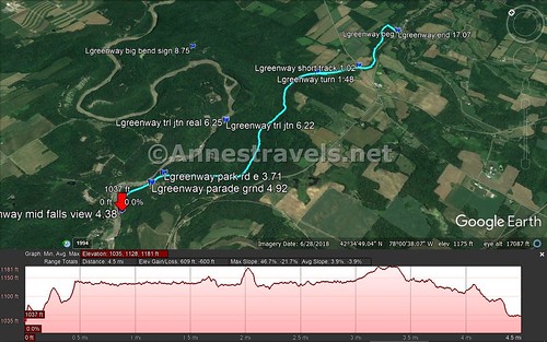
Round Trip Trail Length: From the Oakland Locks to the view over Middle Falls, the total distance is about 8.75 miles. I did a total of 17 miles, but I also went in quite a few circles, including one or two things that don’t show up on the map. Trail #6 is supposedly a total of 0.8 miles one way.
Total Elevation Gain: The Genesee Valley Greenway portion of the trail has about 600ft. of elevation gain (1,035ft. to 1,182ft.)
Facilities: Lodge, picnic area, and restrooms at the Parade Ground. None at the Oakland Locks.
Fees: None if you park at the Oakland Locks. If you want to park in Letchworth State Park and you can’t prove you’re 62+, there’s a $10 entrance fee.
Trail Notes: The trail is much easier to bike if you skip the lock section, but it’s really up to you. The Genesee Valley Greenway is open 6am to 10pm to bicyclists, horseback riders, snowmobilers, hikers, and x-country skiers. Motorized vehicles are prohibited, as are alcoholic beverages and campfires. Please respect the rights of landowners adjacent to the trail.

Trail 
![]()
![]()
Road ![]()
Signs ![]()
![]()
Scenery ![]()
![]()
Would I go 100 miles out of my way for this? ![]()
![]()
Overall Rating: ![]()
![]()

GPS Coordinates for the Genesee Valley Greenway between Oakland Locks and Letchworth State Park East
Lock Parking: 42.5784167°, -077.9710667° (N42° 34.705′ W77° 58.264′ / 42°34’42.3000″, -077°58’15.8400″) (1,045ft.) (0.0)
Short Track Road: 42.5780500°, -077.9875500° (N42° 34.683′ W77° 59.253′ / 42°34’40.9800″, -077°59’15.1800″) (1,192ft.) (1.02)
Turn: 42.5820000°, -077.9942333° (N42° 34.920′ W77° 59.654′ / 42°34’55.2000″, -077°59’39.2400″) (1,147ft.) (1.48)
Letchworth Park Road: 42.5848500°, -078.0303500° (N42° 35.091′ W78° 01.821′ / 42°35’05.4600″, -078°01’49.2600″) (1,137ft.) (3.71)
Middle Falls View: 42.5847667°, -078.0389167° (N42° 35.086′ W78° 02.335′ / 42°35’05.1600″, -078°02’20.1000″) (1,144ft.) (4.38)
Parade Grounds: 42.5848667°, -078.0328500° (N42° 35.092′ W78° 01.971′ / 42°35’05.5200″, -078°01’58.2600″) (1,198ft.) (4.92)
Trail Junction: 42.5858000°, -078.0148667° (N42° 35.148′ W78° 00.892′ / 42°35’08.8800″, -078°00’53.5200″) (957ft.) (6.22)
Actually the trail junction: 42.5858833°, -078.0147167° (N42° 35.153′ W78° 00.883′ / 42°35’09.1800″, -078°00’52.9800″) (923ft.) (6.25)
Big Bend Sign by cabins: 42.6012333°, -078.0029500° (N42° 36.074′ W78° 00.177′ / 42°36’04.4400″, -078°00’10.6200″) (865ft.) (8.75)
End at the lock parking: 42.5781667°, -077.9712500° (N42° 34.690′ W77° 58.275′ / 42°34’41.4000″, -077°58’16.5000″) (1,053ft.) (17.07)
The gpx file for the Genesee Valley Greenway can be downloaded – please note that this and the GPS Coordinates are for reference only and should not be used as a sole resource when hiking this trail.
Download GPX File size: 29.3 KB Downloaded 546 times
(Note: I do my best to ensure that all downloads, the webpage, etc. are virus-free and accurate; however, I cannot be held responsible for any damage that might result, including but not limited to loss of data, damages to hardware, harm to users, from use of files, information, etc. from this website. Thanks!)
Note: Unfortunately, my GPS wasn’t tracking our route on the way out. So the GPX file only shows from the Middle Falls Viewpoint back to Oakland Road (via the railroad bed not by the canal locks).
Getting to the Oakland Locks Parking Area
From I-90 east of Buffalo, take Exit 48A for NY 77 toward Pembroke and Medina. After paying the toll, turn right onto NY-77S for 7.2 miles. Turn left onto Hwy 20E for 1.9 miles, then right onto NY-238S for 4.2 miles. Take a right onto Market Street for 0.3 miles, then turn left onto NY-238S for another 10.7 miles. When NY-238S crosses US-20A, the road changes names to Hermitage Road; continue straight another 6.6 miles. Turn left on NY-78S for a quarter mile, right on Hardys Road for 5.2 miles, and then left on NY-39E for 2.1 miles (at which point the road changes names to Griffith Road; continue straight another 4.7 miles). A sign here will point left toward Letchworth State Park. Continue straight 0.3 miles and turn left on NY-436E. After 4.5 miles, turn left on Oakland Road; the parking area is immediately on the left.
From I-90 west of Syracuse, drive south on I-390 to Exit 7, signed for Letchworth Park (a salt mine can be seen on the east side of the road just before the exit – the rail service that takes the salt to market is called the “Genesee and Wyoming Railroad” and has often won the “safest railroad in North America” award, despite the fact that they now own hundreds of other small railroads around the world). At the bottom of the ramp, turn left on NY-408S 1.9 miles into the town of Mount Morris (if you need supplies, this is the place to stock up). Turn left on Main Street, then take a quick right on NY-408 and drive 7.6 miles. Just before driving down the hill in Nunda (pronounced nun-DAY), take a right onto Short Tract Road. After 3.5 miles, turn left onto Oakland Road. The parking area will be on the right just before the road intersects the main road at the bottom of the hill, 1 mile from where you turned off Short Tract Road.
From I-86, take Exit 31 toward Peacock Hill Road. Turn left on Peacock Hill Road for 0.4 miles; turn left on E Main Street for 0.2 miles, and take the 2nd exit in the traffic circle to stay on Main Street another 0.6 miles. Turn right on Peavy Road and after only 0.1 miles, take a slight left to stay on Peavy Road another 0.9 miles. Turn right onto County Road 15 for 14.2 miles, then continue straight on Short Tract Road for 0.8 miles. Turn right onto NY-436E for 1.3 miles. Turn left on Oakland Road; the parking area is immediately on the left.
Zoom map out to browse nearby hikes & places of interest
This Week’s Featured Product!
If exploring rock formations is your thing, this book could be an excellent place to begin exploration of rock cities and rock formations in western New York.