
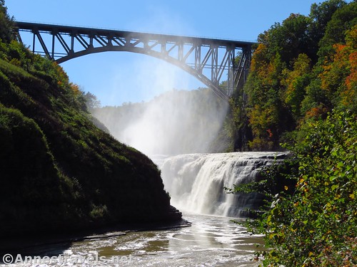
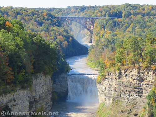
The Upper Falls and new trestle across Letchworth Gorge
Letchworth State Park is, to me, one of the best attractions in Western New York (excluding Niagara Falls of course!) Not only do you get views of three impressive waterfalls, but there are also numerous options for hiking, scenic drives, history, and more. And in October, the view with the colorful leaves is beyond spectacular. A day is plenty of time to see the major sites (in fact, I’ve always visited as a day trip), but if you want to spend a few more days, you can dig deeper into the trails and history.
Quick Stats

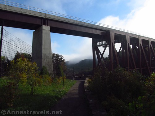
The new and old trestles
I started out at the Upper Falls, beneath the new rail bridge over Letchworth Gorge. (The older bridge was demolished in early 2018 – they left one girder from the old bridge at the entrance to the parking area, so you can see just how much more massive the current bridge is!). The mist still hung over the gorge (cool fall night + high humidity = early morning fog), so we crossed the road and took the very obvious trail up the hill.
Looking back at the new trestle
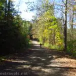
As it turned out, we were following the Mary Jemison Trail (Trail #2 on the official park map). The first section is hilly, then it connects with a not-so-old dirt road and becomes much more hikable. We walked 1.3 miles on the Mary Jemison Trail, staying straight on the road at various junctions, to a gate that led to what looked like a snowmobile camp. In general, it was a pleasant hike through the forest, but nothing more than that. Perhaps it was a bit more interesting because the trees were beginning to change color, so we had a bit of a “yellow wood” experience.

Along the Mary Jemison Trail #2
The day was moving on, so we turned around and retraced our steps back to the park road and the rail bridge. (Note: It is technically a trespassing offense to go out on the railroad and out on the bridge, and fences have been installed to making climbing onto the trestle more difficult.)

Looking past the trestle girders to the mist from the Upper Falls
At this parking area, you’re actually above the upper falls. So we descended the stairs to better views of the falls.
Most of these photos were taken later in the day, on our way back. The early morning sun in early October is too far south and too low in the sky to get very good pictures early in the morning.

Views up to the Upper Falls
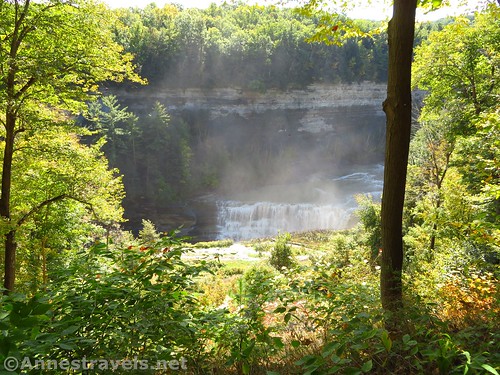
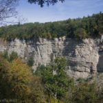
The pathway continues down past a picnic area, a much larger parking area, and restrooms before it comes to the brink of Middle Falls 0.7 miles below the Upper Falls/bridge parking area. There’s a small viewpoint nearby – the view is good from here, but continue up the trail a little way, as well, to see another great view of the falls.

Middle Falls from above
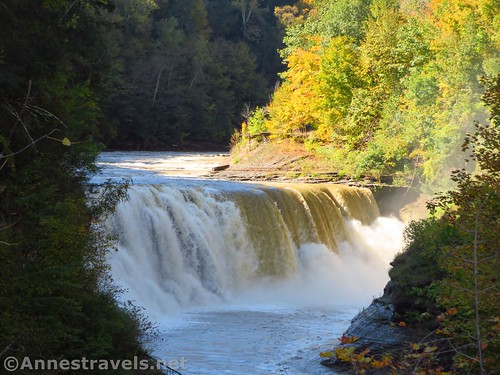
The water was extremely high on this visit (probably due to heavy rain the previous day). Usually, the Middle Falls is no more than 2/3 across the riverbed. But that day it was all the way across!
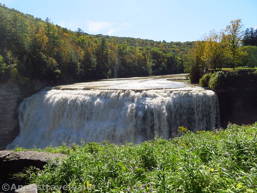
Middle Falls
We kept walking up the sidewalk to the road, then up the road to a viewpoint, then up along the gorge/road until the trail veers off along the edge of the gorge again. From here, it’s a pleasant forest walk (with peek-a-boo views to the gorge) down to Inspiration Point about 0.8 miles from the Middle Falls.
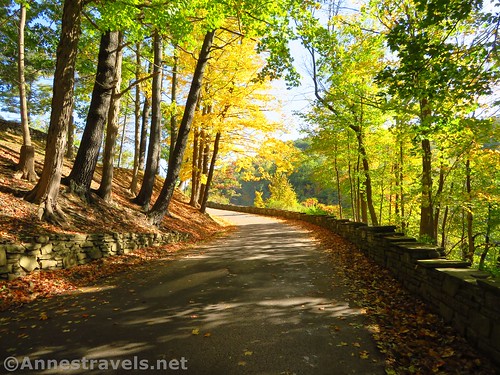
Walking up the road
The views of the trestle, Upper Falls, and Middle Falls from Inspiration Point are spectacular!
Close up of the views from Inspiration Point
We kept walking on the path along the edge of the gorge. There aren’t much more in the way of views for a bit, but there is one rather interesting stairway (steep and long!) About 0.8 miles from Inspiration Point, the path finally levels out in what was once a campground. I’m not sure what they’re currently doing with it, but there is a decent view down on the Lower Falls.
The Lower Falls from the old camping area
At one time, this was the best view of the Lower Falls you’d get. Now, though, there’s a better viewpoint if you don’t mind working for it. Continue along the path, past the playground, to where the trail for the Lower Falls descends via a stone stairway (the trail is well-marked).

Lower Falls from the grassy shelf – again, the water was very high that day
The trail is very steep, and at the bottom of the stairs, social trails stretch in nearly every direction. For now, turn right on the most-used looking trail. At one time, this would take you to a sign that said “Area Behind This Sign Closed”, but now there is no sign, so you can walk out onto a grassy space where you can actually see the Lower Falls.

Looking downstream from the Promenade
After looking at the falls, we took social trails down to the “Promenade”. At one time, there would be dances and other frolics on this pavement; now, there are occasionally weddings. From the Promenade, a trail goes down to the bridge across the gorge to the other side – the park is currently doing renovations to the bridge area, so the trail was closed. Still, we were able to eat lunch and enjoy the view of the gorge up to the Lower Falls.
Lower Falls Views (close up) from the Promenade
We were just taking the trail away from the Promenade when we heard a Bang! Crash! from behind us. We tripped and slid and scrambled the fastest social trail possible back down to the pavement. Right across from where we had been eating lunch, a huge rock had fallen off the cliff wall and into the water. We stuck around long enough to see some smaller rocks fall into the gorge before hiking back up to the rim.

Rocks falling from the canyon wall. Makes me feel so safe!
From here – at least the way my GPS track works – we continued down the path along the rim. It goes down to the park pool area and continues beyond the statue commemorating the Civilian Conservation Corp in Letchworth. But here’s the thing the park historical signs won’t necessarily say: According to one of my group members, who wrote the local history of the area for the US government in the 1970s and spoke to many first-hand resources, the CCC camp had barely been established on the Civil War Parade Ground across the river when WWII broke out. Suddenly, instead of CCCs the US was drafting all the men possible into the armed forces.

Old photo of the wooden trestle (right) and the canal that was replaced by a railroad along the rim of the gorge
So what to do with a perfectly good camp that had barely been used? Turn it into a POW camp for German soldiers. And even today, if you go to northern Germany, you’ll see stonework just like the stonework in many parts of Letchworth.

Looking down into the gorge from the road below Middle Falls
Actually, it was dangerous to have a POW camp in the area. A well-established fifth column was known to exist, and sympathies of the locals definitely sided with the Axis. The US government sent troops out to guard the railroad bridges for fear someone would sabotage the supply lines between Buffalo, New York, and other cities.

The current rail line disappearing into the mist above the current trestle over Letchworth Gorge
But that was then, and this was now, and instead of continuing on the rim path, we took the road down to Lee’s Landing, about 1.25 miles from the Lower Falls parking area.
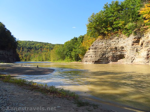
Cliffs and views downstream from Lee’s Landing
It’s steeply downhill, but a wide gravel road the whole way. It’s kept open for raft trips. At the bottom, there’s a little gravely beach, a cliff wall across the river, and not much else.
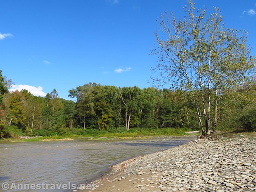
Looking upstream from Lee’s Landing
And we were running low on time, so we huffed and puffed our way back up to our vehicle. But it’s a great trail, and if time had allowed, I wouldn’t have minded checking out the further reaches of the Rim Trail.
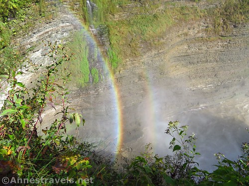
Double Rainbow at the Middle Falls
Round Trip Trail Length: 6.5 miles not including the Mary Jemison Trail or the trail from the Lower Falls to Lee’s Landing. Add 2.5 miles (RT) to include Lee’s Landing and/or 2.7 miles to include the section of the Mary Jemison Trail that I hiked.
Total Elevation Gain: 3,891ft. (1,373ft. to 729ft.)
Facilities: Seasonal restrooms and picnic areas at the Middle Falls and Lower Falls. Snack bars also are seasonal at the Middle and Lower Falls. Year round, a playground is available at both the Middle and Lower Falls. A pool is located below the Lower Falls.
Fees: $10/vehicle/day. If your vehicle has a senior (62+) in it, the fee is waived with proof of the senior’s age (driver’s license, for example). Empire Passes also accepted.
Trail Notes: You can drive to the top of the Upper Falls, just above the Middle Falls, near Inspiration Point, near the top of the stairs down to the Lower Falls, and the area near the CCC statue. So if you just don’t feel like hiking, driving is a definite option. If you don’t want to hike everything, I highly recommend just doing the path between the Upper Falls and Middle Falls, as this has some of the best views on the entire hike (Inspiration Point is the only other contender for “best views”).
Trail 
![]()
![]()
Road
Signs ![]()
Scenery
Would I go 100 miles out of my way for this?
Overall Rating: 

A turkey vulture soars over the gorge
GPS Coordinates for Letchworth State Park
Snowmobile Camp (?) Mary Jemison Trail: 42.588880, -78.058603 (N42°35.33280′, W078°03.51618′ / 42°35’19.9680″, -078°03’30.9708″) (0.0)
Bridge Overlook: 42.5780500°, -078.0500833° (N42° 34.683′ W78° 03.005′ / 42°34’40.9800″, -078°03’00.3000″) (1,267ft.) (1.35)
Middle Falls: (42.5838000°, -078.0425667° (N42° 35.028′ W78° 02.554′ / 42°35’01.6800″, -078°02’33.2400″) (1,027ft.) (2.07)
Inspiration Point: 42.5880500°, -078.0347000° (N42° 35.283′ W78° 02.082′ / 42°35’16.9800″, -078°02’04.9200″) (1,212ft.) (2.81)
Lower Falls View: 42.5864500°, -078.0209167° (N42° 35.187′ W78° 01.255′ / 42°35’11.2200″, -078°01’15.3000″) (989ft.) (3.68)
Lower Falls Parking Area: 42.5878833°, -078.0158833° (N42° 35.273′ W78° 00.953′ / 42°35’16.3800″, -078°00’57.1800″) (939ft.) (4.04)
Lower Falls: 42.5858500°, -078.0206833° (N42° 35.151′ W78° 01.241′ / 42°35’09.0600″, -078°01’14.4600″) (861ft.) (4.44)
Promenade Area: 42.5864500°, -078.0177500° (N42° 35.187′ W78° 01.065′ / 42°35’11.2200″, -078°01’03.9000″) (825ft.) (4.64)
Lees Landing: 42.5984333°, -078.0073500° (N42° 35.906′ W78° 00.441′ / 42°35’54.3600″, -078°00’26.4600″) (724ft.) (1.25 from Lower Falls Parking)
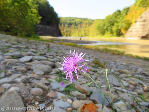
Wildflower at Lee’s Landing
The gpx file for the Rim Trail in Letchworth State Park can be downloaded – please note that this and the GPS Coordinates are for reference only and should not be used as a sole resource when hiking this trail.
Download GPX File size: 94.1 KB Downloaded 353 times
(Note: I do my best to ensure that all downloads, the webpage, etc. are virus-free and accurate; however, I cannot be held responsible for any damage that might result, including but not limited to loss of data, damages to hardware, harm to users, from use of files, information, etc. from this website. Thanks!)

Views from Inspiration Point
Getting to Letchworth State Park
I highly recommend entering through the Portageville Entrance (far south of the park). Google will tell you that if you’re coming from the north, coming in the northern entrance is faster, but waggling along on the road at 30mph through the trees isn’t my favorite mode of travel…

Walking up the road between Middle Falls and Inspiration Point
From I-90 east of Buffalo, take Exit 48A for NY 77 toward Pembroke and Medina. After paying the toll, turn right onto NY-77S for 7.2 miles. Turn left onto Hwy 20E for 1.9 miles, then right onto NY-238S for 4.2 miles. Take a right onto Market Street for 0.3 miles, then turn left onto NY-238S for another 10.7 miles. When NY-238S crosses US-20A, the road changes names to Hermitage Road; continue straight another 6.6 miles. Turn left on NY-78S for a quarter mile, right on Hardys Road for 5.2 miles, and then left on NY-39E for 2.1 miles (at which point the road changes names to Griffith Road; continue straight another 4.7 miles). Take a left onto the park road, following signs for Letchworth State Park, pay the entrance fee, and continue 0.5 miles under the bridge to the small parking area (or continue slightly further to the turnoff for Upper and Middle Falls to park in the larger parking area).

Side view of Middle Falls
From I-90 west of Syracuse, drive south on I-390 to Exit 7, signed for Letchworth Park (a salt mine can be seen on the east side of the road just before the exit – the rail service that takes the salt to market is called the “Genesee and Wyoming Railroad” and has often won the “safest railroad in North America” award – beyond the salt mine, they now own hundreds of other small railroads around the world). At the bottom of the ramp, turn left on NY-408S 1.9 miles into the town of Mount Morris (if you need supplies, this is the place to stock up). Turn left on Main Street, then take a quick right on NY-408 and drive 7.6 miles. Just before driving down the hill in Nunda (pronounced nun-DAY), take a right onto Short Tract Road. After 5.2 miles, the road will end next to some blue silos; turn right onto NY-436W for 3.5 miles, then turn right onto NY-19A for 0.3 miles. Take a right onto the park road, following signs for Letchworth State Park, pay the entrance fee, and continue 0.5 miles under the bridge to the small parking area (or continue slightly further to the turnoff for Upper and Middle Falls to park in the larger parking area).
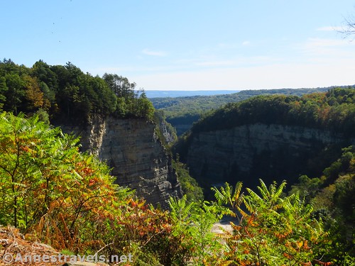
Views across the gorge to the hills beyond
From I-86, take Exit 31 toward Peacock Hill Road. Turn left on Peacock Hill Road for 0.4 miles; turn left on E Main Street for 0.2 miles, and take the 2nd exit in the traffic circle to stay on Main Street another 0.6 miles. Turn right on Peavy Road and after only 0.1 miles, take a slight left to stay on Peavy Road another 0.9 miles. Turn right onto County Road 15 for 14.2 miles, then continue straight on Short Tract Road for 0.8 miles. Turn left onto NY-436W for 3.2 miles, then turn right onto NY-19A for 0.3 miles. Take a right onto the park road, following signs for Letchworth State Park, pay the entrance fee, and continue 0.5 miles under the bridge to the small parking area (or continue slightly further to the turnoff for Upper and Middle Falls to park in the larger parking area).
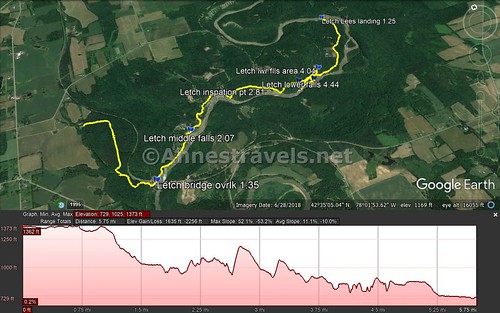
Trail map of my trek – far left is the snowmobile camp(?) on the Mary Jemison Trail, then on the Rim Trail all the way down to Lee’s Landing (but not back)
Zoom map out to browse nearby hikes & places of interest
This Week’s Featured Product!
I love this book for finding waterfalls in western and central New York! Beyond the popular trails (Niagara Falls, Letchworth, Watkins Glen, etc.) there are some hikes even the locals might not have heard of.


Wonderful pics. I got to visit Letchworth briefly in September 2018. I tried to get info at visitor center to spend greater time visiting. However, they suffered a major power outage and various roads were closed within and near the park. As a result I didn’t stay. Thank you for sharing so much. I hope to return again.
Mykel, So glad you even had a brief visit. I’ve been blessed to visit several times, and it’s always a treat, no matter how short a time I can stay. ~Anne
Pingback: Genesee Valley Greenway - Oakland to Letchworth - Anne's Travels