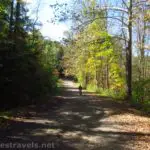
Quite a number of years ago, I took the rails-to-trails known as the Genesee Valley Greenway from the town of Mt. Morris to the Brookdale Preserve (just south of Rochester, NY). Then last year, I took the section of the Greenway from Oakland to the place where the trail was taken out by a landslide in the 1970s in Letchworth State Park. This fall, I took another good, long section of the Genesee Valley Greenway – from Fillmore to Belfast. The good thing about this route is that most of it is on the trail itself, with only a few short detours on Route 19 (there’s always a shoulder to ride on) – which isn’t always true about other sections of the trail.
Quick Stats

We parked behind the Dollar General in Fillmore (a good map can be found here; get the PDF on this page). From here, you can ride up the dirt road by the baseball diamond to access the railroad bed. Supposedly, the trail only goes left (south), but it looks like the trail goes both directions. Turn southward to take the trail downhill to cross over Route 19 and continue as the trail follows the Genesee River.
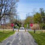
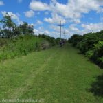
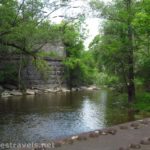
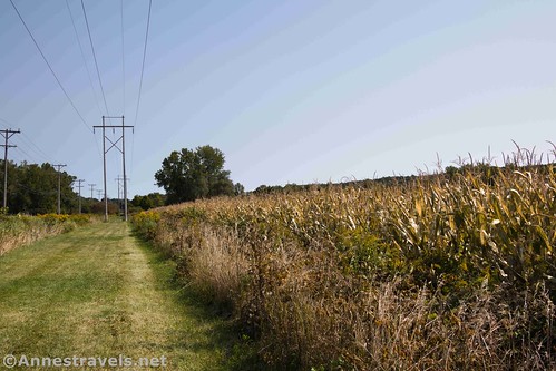
The trail passes a small waterfall and under powerlines, past fields and a few houses. In this section, the trail is all grass, which makes biking harder than I really wanted. At Lattice Bridge Road, the trail takes a sudden turn out onto Route 19, then back onto the Greenway a short distance later. Most of these jags out onto the road are due to missing bridges on the Greenway, so they may be eliminated if funding for the bridges is secured.
Shortly after passing an electric facility about mile 3.5, the trail dips to cross a small creek. On the other side of this creek, the trail more or less vanishes into fields owned by Houghton College. Turn slightly right across the parking area and pick up the trail to the left of the trees.

The Genesee Valley Greenway passes just to the southeast of the village of Houghton, so it’s a bit built up on the right side of the trail for a bit. The only tricky spot is where the trail skirts another electric station. Go around the back, then go toward the road, and the trail is obvious.

The next section of the Greenway is in the forest, past swamps and occasional streams. I expect it would be quite buggy if you stopped long enough for the bugs to catch up with you. Otherwise, it’s a nice ride until – quite suddenly – the trail ends in a pile of brush. A bridge is missing just ahead, and while it’s obvious that hikers don’t mind continuing by scrambling down the embankment and back up the other side, it’s not someplace I’d want to take a bicycle. Thankfully, there’s a nice trail up to Route 19. Turn left on the road and follow it about a half mile to where the trail picks up – on the right side of the road about mile 6.0.

There’s no more excitement until you get to Caneadea about mile 7.25. The trail supposedly crosses Cemetery Road, goes through several front yards and at least one back yard, then jumps out to Route 19 to cross over Cascade Creek on the road bridge (what did I mention earlier about bridges?) We couldn’t locate the trail on the south side of Cemetery Road, so we hopped out onto Route 19 (it’s visible from where the trail crosses Cemetery Road) to the other side of Cascade Creek.

Right after the bridge, the trail supposedly picks up again immediately, on the right side of the road. However, that would mean crossing a guardrail, and since we didn’t see any sign of a trail, we kept going down the road. This was the only place where we got seriously confused, so I’ll try to help you out: Keep going down Route 19 past Allegany County Road 49. On your left at this point is a parking area for accessing the river. Keep riding down Route 19. A second parking area will be on the left; go to the far southern end of this parking area and duck down on the dirt road that heads toward the Genesee River. The Genesee Valley Greenway will be on the right.

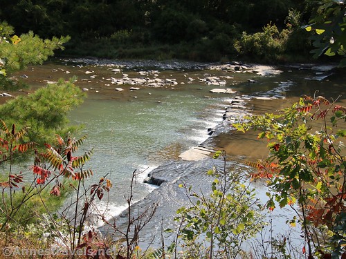
More grass riding leads down past views of the Genesee River to a road bridge (on the Greenway) over Crawford Creek. A short distance after this, the trail crosses Route 19 back to the western side of the road just outside of the town of Oramel about mile 8.8.

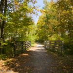
Now begins my favorite part of this section of the Genesee Valley Greenway. For one thing, the trail is hard-packed dirt/gravel instead of grass (which is a truly nice change of pace and much easier riding). Second, the forest is sublime. You could almost be out in the middle of nowhere here, except for the sound traffic and occasional views of Route 19. We even saw some lumberjacks at work (though what they were doing is a mystery to me).

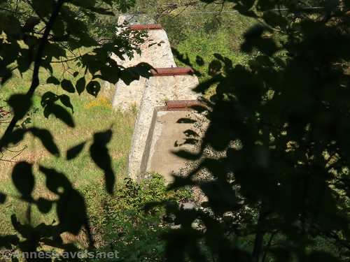
About a mile before Belfast, the trail passes by some concrete pillars. These were once the foundations for the Genesee Viaduct that carried the Erie Railroad across the Genesee Valley. Once called “The Longest Bridge in the World” and “The Mile-long Bridge,” the viaduct was 3,121ft. long (though supposedly the China Bridge was longer and the “mile” part come from the approaches to the bridge) and 141ft. above the Genesee River. It was also the longest high-bridge in New York, constructed in 1906-1907 by the Willard Construction Company as a Deck Plate Girder design. To put it in perspective, the Kinzua Bridge in Pennsylvania is only about 2/3 the length. You can see vintage photos of the Genesee Viaduct on the Library of Congress Website and also on Bridgehunter.
One of my biking companions told me that the bridge was considered a major artery for munitions during WWII. The area was primarily German, with strong pro-Nazi sentiments, so there were guards 24/7 on both sides of the bridge. Either because of the guards or because no one tried, there were no attempts on the bridge during the war.

I scrambled around and found some more pillars and some historic debris (wooden pieces, etc.) My biking companion lived in the area in the late 1970s and walked across the Genesee Viaduct before it was torn down in 1981. According to his then-girlfriend (now-wife of nearly 40 years) about a similar trestle in the area, “It was… exciting.”

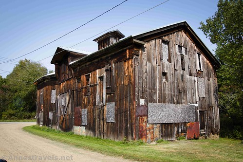
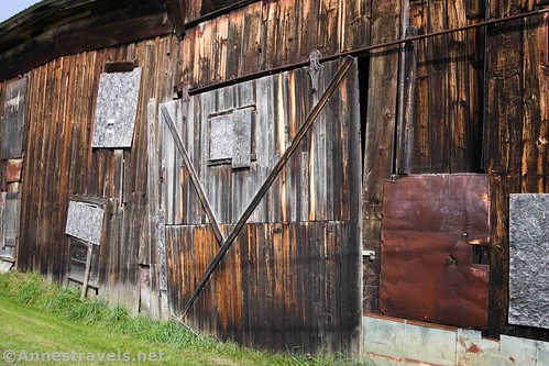
Keep going down the trail almost another mile to where it crosses a small road. Instead of crossing it, turn right to an old wooden building on the left of the road. This is the Genesee Valley Canal Warehouse (much of the Genesee Valley Greenway in this section follows the old canal, and you can occasionally see where the canal was beside the Greenway). The warehouse (also called the Rail and Titsworth Warehouse) has a rather colorful history (think wild-west fiction) and is now protected under the NYS Environmental Protection Fund.
At this point, we really needed to get back home, so we turned around. The trail only continues a short distance before going back out on roads. It’s hit and miss down to Black Creek and almost entirely miss down to Cuba and Hinsdale.

Overall, except for the Oramel to Belfast section, I would not call this the nicest part of the Genesee Valley Greenway. But it is a great bike ride if you happen to be in the area, and the views of the Genesee River and various historical elements makes it worthwhile.
Trail Length: 11.25 miles one-way from Fillmore to the Genesee Valley Canal Warehouse in Belfast
Elevation Gain: 1,240ft. (1,174ft. to 1,345ft.)
Facilities: You might find a restroom at one or two trailheads, but it’s unlikely during COVID. You pass through plenty of small towns, so you should be able to find stores and restaurants.
Fees: None
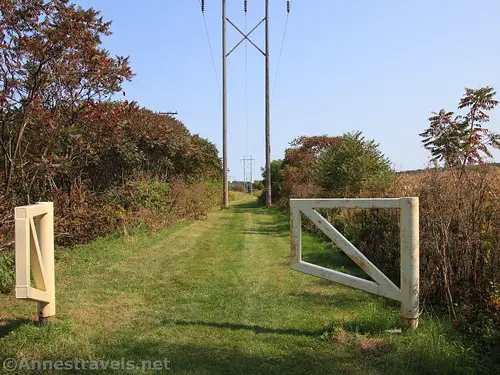
Trail Notes: Much of the trail is grass, which makes biking more strenuous. In fact, we came back mostly on Route 19 (which has good shoulders even though semis often use the road). If you’re ever in doubt about where to turn to get back on the Greenway, most of the entrances have yellow gates – so it’s easy to spot!
Trail 
![]()
![]()
Road ![]()
Signs ![]()
Scenery ![]()
![]()
![]()
Would I go 100 miles out of my way for this? ![]()
![]()
Overall Rating: ![]()
![]()

GPS Coordinates for the Genesee Valley Greenway – Fillmore to Belfast
Trailhead in Fillmore: 42.4629000°, -078.1146667° (N42° 27.774′ W78° 06.880′ / 42°27’46.4400″, -078°06’52.8000″) (1,191ft.) (0.0)
Pick up trail: 42.4016833°, -078.1687000° (N42° 24.101′ W78° 10.122′ / 42°24’06.0600″, -078°10’07.3200″) (1,239ft.) (6.0)

Genesee Canal Warehouse: 42.3426333°, -078.1256500° (N42° 20.558′ W78° 07.539′ / 42°20’33.4800″, -078°07’32.3400″) (1,336ft.) (11.25)
Remains of Bridge: 42.3548833°, -078.1265000° (N42° 21.293′ W78° 07.590′ / 42°21’17.5800″, -078°07’35.4000″) (1,307ft.) (12.19)
End: 42.4631000°, -078.1140000° (N42° 27.786′ W78° 06.840′ / 42°27’47.1600″, -078°06’50.4000″) (1,182ft.) (22.31)

The gpx file for the Genesee Valley Greenway can be downloaded – please note that this and the GPS Coordinates are for reference only and should not be used as a sole resource when hiking this trail.
Download GPX File size: 103.4 KB Downloaded 382 times
(Note: I do my best to ensure that all downloads, the webpage, etc. are virus-free and accurate; however, I cannot be held responsible for any damage that might result, including but not limited to loss of data, damages to hardware, harm to users, from use of files, information, etc. from this website. Thanks!)

Getting to Fillmore
From the I-390 exit for Mt. Morris, turn west toward Mt. Morris. After less than 2 miles, turn left onto Main Street; take an immediate right onto NY-408S aka Chapel Street. Turn right onto River Road after 2.6 miles, then drive 2.1 miles and take a slight left onto Oakland Road. At the top of the hill, turn right onto Short Tract Road (believe me, this is a very worthy shortcut) to where it T’s into NY-436 W near some blue silos. Turn right here for 3.5 miles; turn left at the T onto NY-19A S for 9.1 miles. Keep going straight another 0.2 miles over the bridge; turn right on the dirt road between the park and the Dollar General; park behind the Dollar General since it’s only private residences up the road.
Getting to Belfast
From I-86, take Exit 30 toward Belmont and Wellsville. Turn north on Route 19 for 6.8 miles, then turn left onto Hughes Street for 0.7 miles. You’ll cross the Greenway, then an old wooden building will appear on the left. There is a small driveway, where I suppose you could probably park.

This Week’s Featured Product!
With more than 30 trails in New York – a well as trails in Pennsylvania and New Jersey – this is a great book for anyone looking to bike more rails-to-trails.