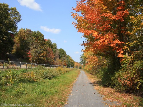
One day at the library, I got out a book about hikes and rail trails in western New York State. There were quite a few great trails there (including many I’d hiked or biked before), but one that intrigued me was the Catharine Valley Trail in the Finger Lakes Region near Watkins Glen. It’s an old rail line and is a rails-to-trails – but it does have a few grades that make you wonder just how a locomotive made it up there! Along the way, the trail passes through swamps, along an old canal, past a 165ft. waterfall, across the highway, and finally ends in a nature preserve. It may not be the most exciting trail on the planet, but it is quite nice, especially for a bike ride in the fall.
Quick Stats

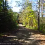
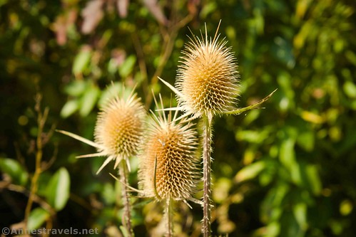
We started in the parking area for the Watkins Glen High School (the trail does go all the way up to the waterfront, but there’s no good parking there – we looked). The trail is very obvious, so it’s not hard to find. It passes behind the athletic fields and then into the Queen Catharine Swamp (named for a prominent Iroquois leader in the late 1700s). The swamp is a favorite for bird-watchers, though we didn’t see anything too exciting as we swept through on our bikes. This part of the trail is flat and easy.

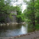
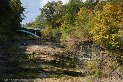
The excitement comes as you exit the swamp about mile 2.1. The trail obviously ends here as the road (busy NY-14) curves in both directions – though technically the trail goes straight a bit further and curves over to North Genesee Street (we couldn’t find it!) There is a small parking area here. Turn right here (you can go up to Aunt Sarah’s Falls if it’s spring – in the fall during a drought, it wasn’t flowing). To continue on the Catharine Valley Trail, before getting to Aunt Sarah’s Falls, turn left on a side street (North Genesee Street). Continue along until just past West Main Street. A park will be on the right; turn right on the sidewalk and walk or bike the short distance to the overlook of Shequaga Falls (pronounced She-qua-ga).
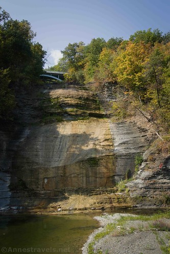
If it’s winter or spring or even early summer or after a good rain, the 165ft. Shequaga Falls is very impressive. Unfortunately for me, it was autumn in the middle of a drought. So there was almost no water. Thankfully, we made up for it later in the day by visiting Deckertown Falls and Eagle Cliff Falls on our way back up the Catharine Valley Trail. (More on that loop later.)
To continue south on the Catharine Valley Trail, turn up West Main Street, then take the first right onto Montour Street. At the end of the street, you should be able to see where the Catharine Valley Trail picks up again.

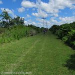
Continue south until you cross South Genesee Street about mile 4.2 (note that there is parking on South Genesee Street along with restrooms). Just after crossing the street, you have a choice: to turn right up the hill or to continue left on the flatter grade. I took the later on the way out and the former on the way back, and there’s no question that the uphill trail is the better one. If it’s the slightest bit wet, you’ll also want to take the upper trail to the right. The lower trail is (as of September 2020) not paved and follows the canal (which is cool), while the upper trail likely follows the railroad grade or at least a roadbed. The choice is up to you, but I definitely found the upper trail to be the better one!

The two trails connect after about 0.75 miles and the ride continues to be somewhat (though not completely) flat through the forest. You can often hear the highway on the left (east), but I didn’t find it annoying. At the top of a hill, the trail will meet up with New Road which will keep changing names as it heads due south – do not take any of the roads that turn left (east) out to the main road. At last, about mile 9, the trail picks up again next to another parking area and a restroom.
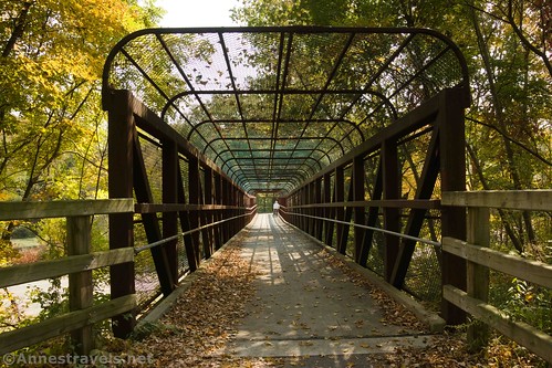
The trail climbs, then, a not-so-distant distance after this, the trail turns left abruptly to cross over the highway (NY-14) via a pedestrian bridge. It continues sedately on the east side of the highway, crossing several small wooden bridges, and finally ends at Huckfinn Road – turn left up the road a short distance to the parking area for the Ek Birding Trail at mile 13.

We hadn’t intended to do the entire Catharine Valley Trail, but since we were here, we sat down at one of the picnic tables to eat lunch and enjoy the autumn blooms in the beds near the parking area. Then we re-mounted our bikes and went back (more downhill this time!) to the Watkins Glen High School, except…
…we decided to stop at Deckertown Falls and Eagle Cliff Falls (Havana Glen Park) on the way. Both are very worth visiting in their own right (in fact, I had planned to post about Eagle Cliff Falls this week (it’s more exciting than the Catharine Valley Trail!) but it’s not open in December, so no go until spring on that one!) To tack on the other two waterfalls to the Catharine Valley Trail, be ready for some elevation gain: as soon as you get out of the valley, the roads are very hilly. At South Genesee Street (after the trail split) turn right (east) to get back out to NY-14. Go left on NY-14, then take the second right onto Havana Glen Road (note that NY-14 is very busy – if you want to avoid that road as much as possible, follow the directions in reverse to visit Deckertown Falls first).

The driveway to Eagle Cliff Falls/Havana Glen Park is just up the road from here, on the right after about a quarter mile (it should have a sign). There is a parking fee, but apparently, it doesn’t apply to cyclists, since we biked right by the booth and no one batted an eyelash. To continue up to Deckertown Falls, return to Havana Glen Road and turn right/east/away from NY-14. Take the first left after about 0.1 miles onto South L’hommedieu Street. The first right (after 0.4 miles) should be East Catlin Street; turn right to the end of the short road for the trailhead for Deckertown Falls. To return to the Catherine Trail, turn right on your way back down East Catlin Street on South L’hommedieu Street. About 0.4 miles later, at Clawson Boulevard, turn left (west) back to NY-14. From here, you can either turn right to ride along NY-14 up to where the Catharine Valley Trail heads north through the Queen Catharine Swamp or else you can turn left on NY-14 a very short distance and then turn right on West Main Street, which will bring you directly to Shequaga Falls.

Round Trip Length: 26 miles to bike between the Watkins Glen High School and the Ek Birding Trail and back. You can also do this as a 13 mile or less shuttle.
Elevation Gain: 3,295ft. – personally, I find this estimate quite an overstatement. There are ups and downs, but it’s not that bad!
Facilities: A few of the road crossings have restrooms; the birding trail does not, but it does have picnic tables.
Fees: None
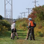
Trail Notes: I’d say this trail is best done as a bike ride. But the trail through the swamp or the section where the trail divides (near South Genesee Street) would both be reasonable hiking trails, as well.

Trail 
![]()
Road ![]()
Signs ![]()
Scenery ![]()
![]()
![]()
Would I go 100 miles out of my way for this? ![]()
![]()
Overall Rating: 
![]()
GPS Coordinates for the Catharine Trail
TH by the High School: 42.3750167°, -076.8630000° (N42° 22.501′ W76° 51.780′ / 42°22’30.0600″, -076°51’46.8000″) (465ft.) (0.0)
NY-14 (turn right and take first left into the town of Montour Falls): 42.350812420424305, -76.85192892059105 (42°21.04875′, -076°51.11574′ / 42°21’02.9247″, -076°51’06.9441″) (2.1)
She-Qua-Ga Falls (Montour Falls): 42.3448500°, -076.8505167° (N42° 20.691′ W76° 51.031′ / 42°20’41.4600″, -076°51’01.8600″) (480ft.) (2.83)
South Genesee Street (near trail split): 42.32841556227805, -76.84433081568531 (42°19.70493′, -076°50.65985′ / 42°19’42.2960″, -076°50’39.5909″) (4.2)
Pick up trail after Morris Hill Road: 42.26393163994298, -76.83845662652665 (42°15.83590′, -076°50.30740′ / 42°15’50.1539″, -076°50’18.4439″) (9.0)

Ek Birding TH: 42.2128167°, -076.8447833° (N42° 12.769′ W76° 50.687′ / 42°12’46.1400″, -076°50’41.2200″) (907ft.) (12.98)
End: 42.3750167°, -076.8630167° (N42° 22.501′ W76° 51.781′ / 42°22’30.0600″, -076°51’46.8600″) (473ft.) (30.35)
Havana Glen Parking for Eagle Cliff Falls: 42.3354167°, -076.8291167° (N42° 20.125′ W76° 49.747′ / 42°20’07.5000″, -076°49’44.8200″) (536ft.) (26.64)
Parking: 42.3434167°, -076.8308833° (N42° 20.605′ W76° 49.853′ / 42°20’36.3000″, -076°49’51.1800″) (521ft.) (25.09)

The gpx file for the Catharine Valley Trail can be downloaded – please note that this and the GPS Coordinates are for reference only and should not be used as a sole resource when hiking this trail.
Download GPX File size: 225.1 KB Downloaded 373 times
You can also download the gpx file for the Catharine Valley Trail plus Deckertown Falls and Eagle Cliff Falls – note that while the map mostly matches up with the directions above, the route went to Deckertown first and then returned via NY-14.
Download GPX File size: 266.0 KB Downloaded 366 times
(Note: I do my best to ensure that all downloads, the webpage, etc. are virus-free and accurate; however, I cannot be held responsible for any damage that might result, including but not limited to loss of data, damages to hardware, harm to users, from use of files, information, etc. from this website. Thanks!)

Getting to the Catharine Valley Trail
From the town of Watkins Glen, drive south to 12th Street – the road is on the left between Burger King and Dunkin’ Donuts (both of which are on the right) shortly after passing Watkins Glen State Park. (If you’re coming from the south, 12th street is on the right a bit north of Tops (on right) and Dunkin’ Donuts (on left).) Turn left (if coming from the north; right if coming from the south) onto 12th Street for 0.3 miles, then turn right onto Perry Street. Take a quick left into a large parking lot behind the high school. There should be a few parking spots open along the trail – at least there were on a Friday in September!

Zoom map out to browse nearby hikes & places of interest
This Week’s Featured Product!
For even more scenic trails in the Finger Lakes, check out this book with nearly 40 hikes across the region. From waterfalls and marshes to Lake Ontario and rock formations, there are a wide variety of five-star hikes.