

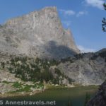
Your first view of Middle Teton in Garnet Canyon
Garnet Canyon in Grand Teton National Park is spectacular. I mean, really, really spectacular. Other hikes (such as Table Mountain) are beautiful, but they don’t have the jaw-dropping splendor of Garnet Canyon. As you’re hiking along, you keep looking up, awed by the majesty of the canyon around you, and wishing you could capture on film (or your SD card) exactly what you’re seeing: Middle Teton, looming up majestically at the head of the canyon, the sheer walls, rising up to the blue sky, and the other nearby peaks that are so much closer than when you’re on the plains looking at the Teton Range. You’re also walking through rock slides and mountain meadows, which enhances the already gorgeous hike. In this post, I’ll tell you how to get up to the end of the Garnet Canyon Trail (to the Meadows), and then how I hiked up toward the Lower Saddle. I didn’t reach the end of the trail, but going above the meadows is well worth it if you’re up to an 11+ mile (17 km+) hike!
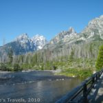
The parking area for the hike is Lupine Meadows, at the south
end of Jenny Lake. This is a very popular parking area; it was quite full when we were there on a weekday in July and had obviously been fuller before we got there and while we were on the hike (we pulled in around 7:15am). You’re not allowed to park on the edge of the road (note the “no parking” signs), so it’s best to get an early start. To get to the parking area from the north, from Jackson Lake Junction, turn onto Teton Park Road (towards Jenny Lake). Drive 13.7 miles (22 km), then turn right onto Lupine Meadows Road—I believe there is a sign for the Jenny Lake Boathouse.

Wildflowers in the lower/middle part of Garnet Canyon
(From the south, drive 8 miles (12.9 km) from the park entrance to Moose Junction. Turn left on the road to Jenny Lake for 7.2 miles (11.5 km) to where a road goes off on the left; the junction is well marked and a sign should point towards the Jenny Lake Boat Launch).
Either way, drive down the “boat launch” road a short ways. Keep going straight to avoid the “employees only” administration area and the Jenny Lake Boat Launch. Then keep left at a fork in the road to avoid entering the parking area for a trail around Jenny Lake (actually, this parking area might not be full, so if the Lupine Meadows parking lot doesn’t have any spaces left, you might be able to park there). At the end of the road is a large parking area with a primitive restroom and a sign board at the far end. Don’t worry if there are a lot of cars parked at the near end of the lot; keep driving and see if one has opened up nearer to the signboard. (A map of the area can be found at http://www.nps.gov/grte/planyourvisit/upload/GRTE_park_map_2011.pdf.)

The “rock garden”
The Lupine Meadows parking area is the start of many different hikes, but all take the same trail for the first 1.7 miles (2.7 km). Start by the signboard, and begin walking through the forest along a trail that at one time was obviously paved—now there are holes in the pavement, as well as some good, paved sections. The trail, which starts out fairly flat, will soon begin to climb, gently at first and then more steeply. At 1.7 miles (2.7 km), you’ll come to the first trail junction. Keep going straight toward Garnet Canyon; this junction is well-marked. Now the trail begins to switchback upward on a dusty trail with some very good views of the valley, including Bradley and Taggart lakes and the Jackson Hole Airport (on the way down, I got to watch a plane land!). Three miles (4.8 km) from the trailhead is the second trail junction, with the trail going straight for Surprise and Amphitheater Lakes, and the left trail going towards Garnet Canyon. This is really a “dividing of the waters”; I’d say about half the people go to the lakes and half to Garnet. Between these two trail junctions, you’ll have lost many of the people who started at the trailhead. Still, the Garnet Canyon Trail is well-traveled, so don’t expect to be alone at any point along the way.

Just below the Meadows
From the second trail junction, the trail continues to switchback upward. After another mile (2 km) or so of climbing, you will suddenly come out of the trees to a rocky section. There, straight ahead of you, is your first view of Middle Teton…and what a view! It’s worth the trail just to see this stunning view, although I’d say the views get better as you go further. We stopped here for a snack and to snap some pictures before we continued up the trail. From here, the trail continues upward along the rocky hillside, with more stunning views of Middle Teton and Garnet Canyon. You’re actually following a rushing stream as it falls towards the valley, so there’s some fun views of the small waterfalls along the stream, as well.

In the Meadows–that’s the South Fork of Garnet Canyon in the background
Less than a mile (a little over 1 km) later, you’ll come a sign. Left goes to the camping area, while right continues up Garnet Canyon. Go right; don’t cross the stream. To get go any further, you’ll have to make your way through a garden of huge rocks and boulders. This isn’t horribly difficult, as someone has made a “trail” through the rocks, but it does require a bit of scrambling. You will need to scramble all the way to the Meadows, which is the official end of the Garnet Canyon Trail. In the Meadows, you will see your last sign, all about camping in the Meadows. The views here are sublime: a green meadow filled with flowers around a trickling creek with huge rock walls all around, and the Teton Peaks all around you. Spectacular! Rest here and return the way you came, or (as I recommend if you’re up to it) continue up the trail towards the Lower Saddle.

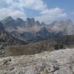
Climbing up above the Meadows
If you want to hike up to the Lower Saddle, do not cross the creek. If the sign about camping in the meadow is right next to the trail you’re on, turn around, re-cross the creek, and then continue up the trail with the creek on your left. You’ll be able to see a large waterfall up on the cliffs ahead of you; you’ll actually go right beneath this waterfall. The trail almost immediately begins to switchback upward quite steeply. Keep looking around you, as the views are really nice. You’re getting higher above the Meadow area, so for a while you’ll be able to see this campground. You are also getting higher and closer to the tops of the peaks—these are all technical climbs. Many people take this trail to get to the staging area for scaling Grand Teton and Middle Teton, so you’ll see plenty of people with ropes, helmets, and other rock climbing gear.

Near the base of the waterfall
After a couple miles (3-4 km), you’ll come to a sign for The Caves. If you don’t want to go all the way to the saddle, this is a great place to turn around. You’ve seen the best of the views in this section, so now you can return to the bottom without wasting energy or time. However, we kept going. After the caves, be on the lookout for where the trail splits. Right will take you up to the hiker’s hut (tent), while left will take you on the trail to the Lower Saddle. This junction is not marked, so you’ll find it or you won’t; you’ll fairly quickly know if you’re on the right trail or not. Not long after this trail split, you will scramble down some rocks and find yourself in a bowl below the saddle. This is as far as we got: due to time-of-day, energy levels, and a brewing thunderstorm, we decided it would be best to go back down. Hopefully someday I’ll post about the Lower Saddle itself, but for now, know that you can follow the trail up and it’s not a technical climb.

The Lower Saddle
Return by the way you came. This is a truly spectacular hike, one of the best in Grand Teton National Park. I can’t wait to do it again soon. By the way, a great map of the area is at http://www.summitpost.org/garnet-canyon-map/121932. The official park map of Garnet Canyon (up to the Meadows) is available at http://www.nps.gov/grte/planyourvisit/upload/Lupine_Meadows_topo.pdf.
Round Trip Trail Length: Between 11 and 12 miles (about 17 km)
Facilities: Signboard and primitive restrooms at the trailhead. None after this unless you have water purification tablets…from the first view of Middle Teton to the waterfall, you’ll be following the stream.
Fees: $25 per vehicle, good 7 days and also valid for entry into Yellowstone National Park. Interagency (America the Beautiful), Senior (Golden Age), Access (Golden Access), Volunteer, Military, and Annual and Grand Teton-Yellowstone passes also accepted.
Trail 
![]()
![]()
Road ![]()
Signs ![]()
Scenery
Would I go 100 miles out of my way for this?
Overall Rating: ![]()
This Week’s Featured Product!
This book covers some of my favorite hikes in Wyoming! There’s a long section on Grand Teton National Park as well as the Wind River Range, Yellowstone, and more.


I am not sure where you are getting your info, but good topic. I need to spend some time learning more or understanding more. Thanks for magnificent information.
Thank you for this blog, it was just what I was searching for. There is so much information here, so I thank you so much.
Pingback: Anne's Travels » 10 Reasons I Choose Dayhiking over Backpacking
Pingback: Anne's Travels » Link Roundup: My Favorite Hiking Websites
Pingback: 15 Must Do Waterfall Hikes Across the US - Anne's Travels
Pingback: Welcome to Anne’s Travels’ New Look! - Anne's Travels
Pingback: Epic Hiking Fail to Epic Hiking Success - Anne's Travels
Pingback: 12 Best Day Hikes in Grand Teton National Park - Anne's Travels