

Located in the far southwest of Yellowstone National Park, Terraced Falls is a hidden gem of a hike. It’s only about 4.6 miles RT – I did it in a morning before I’d developed my trail legs – and it’s likely you’ll have the trail to yourself, at least after the Union Falls Trail goes off a half mile from the parking area. The reason for the lack of popularity is because it’s not accessible by a paved road, nor is it accessible via a road inside the park. Instead, you’ll need to drive a bumpy, somewhat rocky dirt road through Caribou-Targhee National Forest to the trailhead. You’ve got to want to hike this one to do it!
Quick Stats
We arrived at the Cascade Creek Trailhead ‘way out in the middle of the forest very early, while the mist still hung over the forest. This is also the traditional trailhead for Union Falls, and the one other group I met was definitely headed for this more famous destination.
Two signs mark the trailhead – one is on the road informing you that you’re entering a Firewood Unit, and the other is a Yellowstone-type wooden sign stating simply, “Cascade Creek.” Park in the ample dirt parking lot just before these two signs and just after crossing the bridge over Cascade Creek.

Start down the trail to the right of the wooden Cascade Creek sign. If you’re used to hiking in the woods, the path will be very easy to find and follow even if it’s not well marked (and I’m pretty sure some of the trail is a water runoff when it rains). The first 0.3 miles are through Caribou-Targhee National Forest. At this point, you’ll come to a metal sign informing you that you’re entering Yellowstone National Park. Just beyond this are the traditional signs you’d see at most trailheads in Yellowstone – the kind with a map and pertinent information. (I love these maps and wish more national parks consistently had such good maps at their trailheads!)

Continue beyond the signs down another 0.2 miles (the path has mostly been downhill up to this point) to a metal sign at an easy-to-miss junction. The signs inform you that you’ve arrived at Cascade Creek on the South Boundary Trail. Union Falls turns right here and, a short distance later, crosses the relatively large (but often shallow) Cascade Creek. You want to turn left here on a much less-used path. After crossing a very small stream, you’ll come to another sign informing you that you’re on the Terraced Falls Trail (Foot Trail Only, Use of Stock Not Permitted).
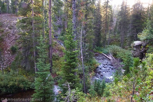
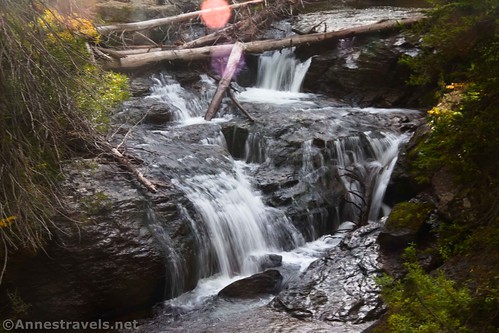
Trail junctions done with (whew!), the path rises slightly through the forest. As the path meanders through lodgepole pines and along Cascade Creek, it passes several series of waterfalls – I counted a total of 5 different sets of cascades and falls, but others noted 6, more or less.

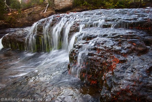
These waterfalls are lovely. Many are small, but the first ones (colloquially known as “Pothole Cascades” due to the holes in the rocks that make up the streambed) are worthy of being a destination unto themselves, being comprised of a set of ledges.
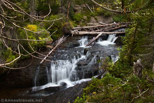
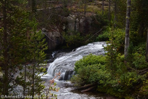
Keep your eyes open for the other small waterfalls in Cascade Creek as you hike – actually, I kept my ears open, since I could often hear the falls before I could see them, and social trail often led to the small falls. The unofficial names for these cascades are Pothole Cascades (very good name, per me!) (40ft.), Diamond Cascade (15ft.), Humpback Cascade (15ft.), and the aptly named two-drop Cleft Cascade (lots of great rock formations in this area!) (20ft.).
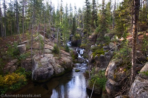
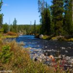
Shortly after the fourth set of falls (about 1.3 miles from the trailhead), the trail turns left. When you meet up with the creek again, it is now the Fall River – Cascade Creek flowed into this larger stream out of sight of the trail. The fifth set of falls is along this section of trail in an area known as “Cascade Acres.”

Right about this point, the moody skies decided to let loose, complete with one good clap of thunder. We did our best “hide-from-a-thunderstorm-in-a-forest” routine while trying to stay dry. Thankfully, it never rained very hard, and it stopped after only a few minutes. We bravely continued the last tenth of a mile to the first viewpoint of Terraced Falls.

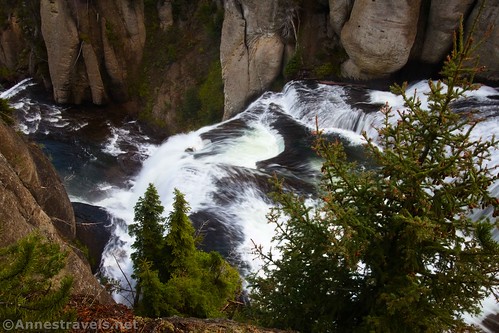
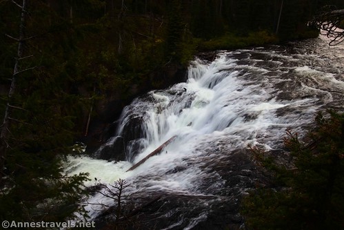
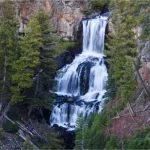
The falls are actually comprised of two separate drops about a tenth of a mile apart. The first is about 50ft. tall; a wide, sparkling mass of tumbling water located about 2.1 miles from the trailhead. The views from this point aren’t very good, so you’ll probably want to continue another 0.15 miles to a place where the bank and trees allow you to stand above the main drop of Terraced Falls. From here, if you move around a little, you should be able to see both drops: One from below (upstream) and the 150ft. terraced drop into a canyon.

This is one of the best viewpoints you’ll get. There are interesting rock formations in the canyon as well as views down the waterfall. You can continue along the riverbank for a bit, but be very careful – there are no guardrails, and I don’t know how undercut the bank is in this section (probably not very, but I don’t know that!)

I did find one other good viewpoint – a rock right on the edge of the canyon that (if you’re crazy) you can see most of the drop of Terraced Falls. I held the camera out and clicked so I didn’t have to get close to the edge! (I love my adjustable-angle live-view screen!)

I scrambled around, hoping to find a place to see the waterfall head-on and/or from the bottom. Unfortunately, that’s pretty much impossible. There are social trails down into the canyon (they’re very steep and not the nicest), but even if I’d climbed down there, a turn in the canyon wall blocked views of the falls. You’d have to wade in the very swift current to get a view from below. I’ve heard of people crossing the Fall River (danger! danger!) up by Cascade Acres and then bushwacking through dense growth to an outcrop on the other side of the canyon. But given the swiftness/depth of the Fall River, that’s something I can’t really recommend.

I settled for the best views I could get from right above Terraced Falls. As we stood there, the sun came out, creating a gorgeous rainbow. Wow!

When you’re done looking, retrace your steps to the trailhead. Even with all of my scrambling around, I only clocked close to 4.6 miles. Not bad for a single autumn morning!

Round Trip Trail Length: 4.6 miles (or a little less)
Elevation Gain: 875ft. elevation gain (7,299ft. to 6,882ft.)
Facilities: None. Though there’s nothing stopping you from camping along the road once you enter the national forest (before that, there are designated free campsites).
Fees: $35/vehicle to enter Yellowstone National Park, valid 7 days. America the Beautiful National Parks & Federal Lands Passes and Yellowstone National Park Passes are accepted. (Not that there’s anywhere to pay if you enter this way… I guess they figure you either paid online along with your backcountry permit or else already have an entrance ticket from exploring the rest of the park!)
Trail Notes: This is a very remote trail. Give yourself extra time to get to the trailhead, and be ready for self-rescue. Stay away from the banks of the river which can be slippery and/or undercut. In spring, I’d imagine the trail could be pretty damp, though the falls would be amazing! Note that all national park rules & regs apply once you’re inside of the park (including camping permits, fishing permits, no dogs etc.)
Trail 
![]()
![]()
Road ![]()
![]()
Signs ![]()
Scenery ![]()
Would I go 100 miles out of my way for this? ![]()
Overall Rating: 
![]()

GPS Coordinates for Terraced Falls
TH (Cascade Creek/Union Falls TH): 44.1290600°, -110.8476430° (44°07.74360′, -110°50.85858′ / 44°07’44.6160″, -110°50’51.5148″) (7,296ft.) (0.0)
Enter Yellowstone National Park: 44.1327000°, -110.8487420° (44°07.96200′, -110°50.92452′ / 44°07’57.7200″, -110°50’55.4712″) (7,201ft.) (0.35)
Union Falls Junction: 44.1338130°, -110.8493280° (44°08.02878′, -110°50.95968′ / 44°08’01.7268″, -110°50’57.5808″) (7,128ft.) (0.48)
Small falls 1 (Pothole Cascades): 44.1361580°, -110.8515810° (44°08.16948′, -110°51.09486′ / 44°08’10.1688″, -110°51’05.6916″) (7,084ft.) (0.71)
Small falls 2 (Diamond Cascaade): 44.1402480°, -110.8535790° (44°08.41488′, -110°51.21474′ / 44°08’24.8928″, -110°51’12.8844″) (7,026ft.) (1.11)
Small falls 3 (Humpback Cascade): 44.1410990°, -110.8545570° (44°08.46594′, -110°51.27342′ / 44°08’27.9564″, -110°51’16.4052″) (7,009ft.) (1.23)
Small falls 4 (Cleft Cascade): 44.1415060°, -110.8544210° (44°08.49036′, -110°51.26526′ / 44°08’29.4216″, -110°51’15.9156″) (6,984ft.) (1.30)
Shortly after this, Cascade Creek flows into the Fall River

Small falls 5 (Cascade Acres): 44.1446330°, -110.8569240° (44°08.67798′, -110°51.41544′ / 44°08’40.6788″, -110°51’24.9264″) (6,962ft.) (1.63)
Terraced Falls 1: 44.1470160°, -110.8644560° (44°08.82096′, -110°51.86736′ / 44°08’49.2576″, -110°51’52.0416″) (6,904ft.) (2.16)
Terraced Falls 2: 44.1473060°, -110.8653620° (44°08.83836′, -110°51.92172′ / 44°08’50.3016″, -110°51’55.3032″) (6,866ft.) (2.30)
Terraced Falls 3: 44.1474230°, -110.8657510° (44°08.84538′, -110°51.94506′ / 44°08’50.7228″, -110°51’56.7036″) (6,834ft.) (2.37)
End at TH: 44.1289200°, -110.8474940° (44°07.73520′, -110°50.84964′ / 44°07’44.1120″, -110°50’50.9784″) (7,291ft.) (4.59)
The gpx file for Terraced Falls can be downloaded – please note that this and the GPS Coordinates are for reference only and should not be used as a sole resource when hiking this trail.
Download GPX File size: 84.9 KB Downloaded 346 times
(Note: I do my best to ensure that all downloads, the webpage, etc. are virus-free and accurate; however, I cannot be held responsible for any damage that might result, including but not limited to loss of data, damages to hardware, harm to users, from use of files, information, etc. from this website. Thanks!)
Getting to the Terraced Falls Trailhead (Cascade Creek Trailhead)
The Grassy Lake Road begins at the turnoff for Flagg Ranch, 2.2 miles south of the South Entrance Station to Yellowstone National Park (and 15.6 miles north of the turnoff for Colter Bay). Follow the sign for Flagg Ranch, then take a quick right turn to pass by some old cabins. Continue straight through the stop sign and heave a sigh of relief that you’re really and truly on Grassy Lake Road.

Shortly after crossing Polecat Creek, pass by a small parking area/trailhead. Continue past a total of 8 campsite areas, another trailhead (Glade Creek; no camping at the trailhead), into the national forest (marked by a cattle guard and a big sign or two), past Grassy Lake Reservoir, across the dam, and up into the woods again until you’re 12.5 miles from the highway. Cross over Cascade Creek (there is a bridge) just before turning right into the parking area.

The washboard on the road can be bad, so take it slow. For the most part, the road is something that could be traversed in a compact car. However, it gets rough once you’re in the national forest. I was glad for high clearance even though it probably wasn’t strictly necessary.

This Week’s Featured Product!
Take your choice of hikes with this great guide to more than 100 hikes in Yellowstone National Park! With your choice of mountains, geothermal features, waterfalls, rock formations, wildlife, and more, there are trails for everyone in this guide. Buy your copy here!


Pingback: How I Hiked 100 Miles in Yellowstone National Park in 11 Days – Anne's Travels
Pingback: 10 Practical Ways to Grow in Favor with God and Man – Anne's Travels