
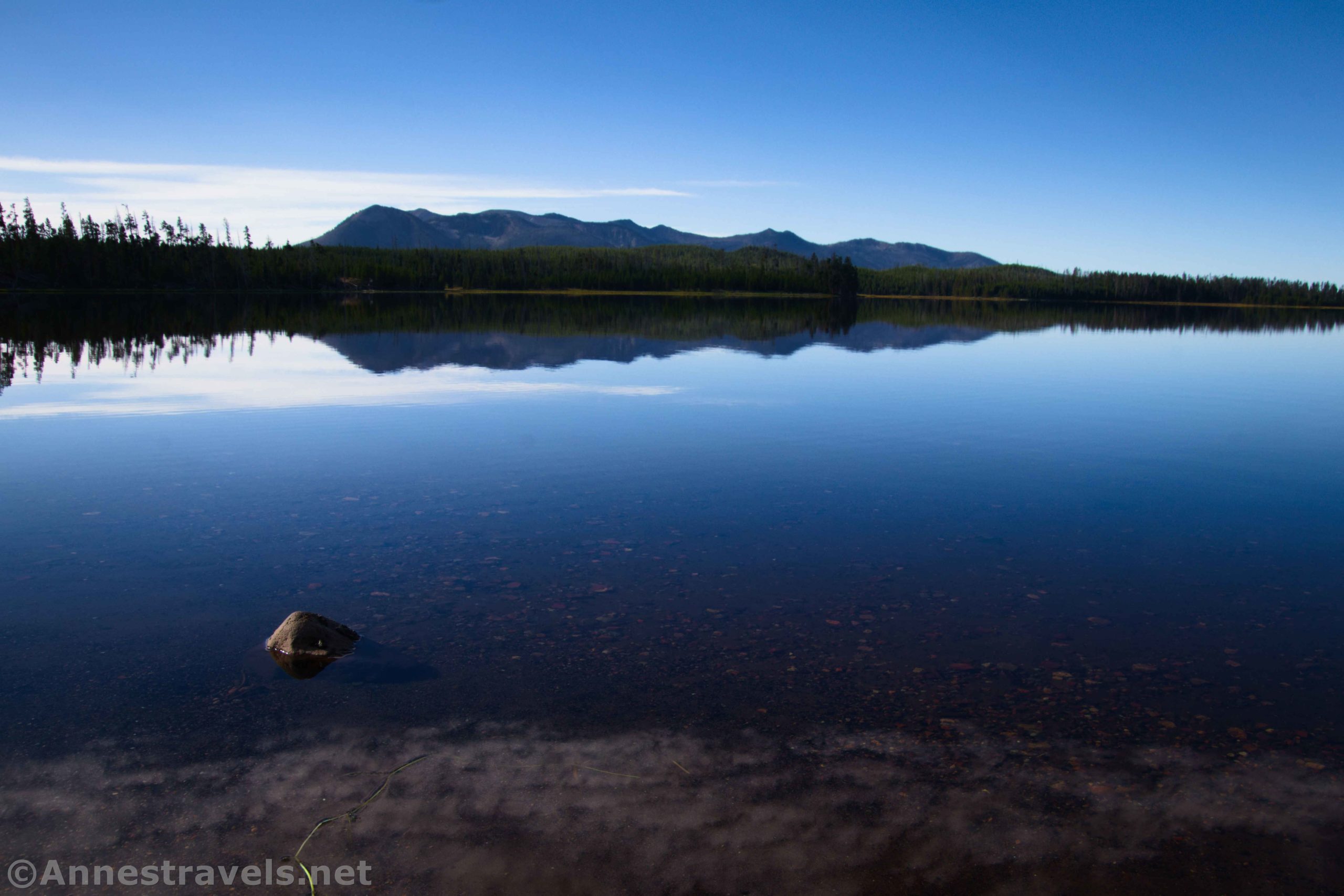

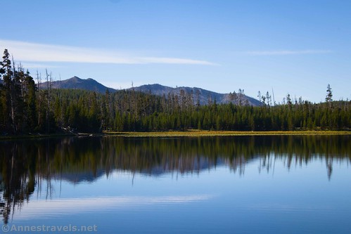
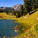
To be honest, I wasn’t expecting a lot when I hiked to Riddle Lake up near the Continental Divide in southern Yellowstone. Lakes are often little ponds (or big ponds) in the forest, and unless there happens to a be a cliffy mountain nearby, they all start looking pretty similar quite quickly. But Riddle Lake happily was much better than this – in fact, it was quite lovely early in the morning with views to Mount Sheridan and nearby hills. Plus, I saw some great wildlife along the way!
Quick Stats
Note: Some of the links in this post are affiliate links. If you click one and purchase something, I may earn a small commission without an extra cost to you.

I started out early one morning in September, but apparently, I should have started even earlier. Very early morning is the best time to visit Riddle Lake, because it’s the best chance to see the most wildlife (I’d imagine sunset timeframe would be good for the same reason). Another hiker said that he and his group had heard quite a few elk bugling – I missed that, but thankfully heard another elk bugling away later in the trip.
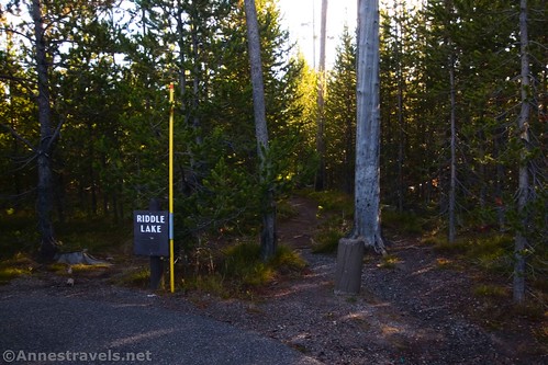
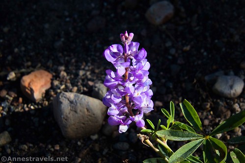
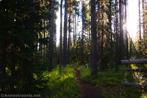
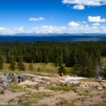
From the trailhead (at the north (Continental Divide) end of the parking area), the trail immediately enters the pine trees. A short walk will bring you to the classic Yellowstone-style metal sign pillars and excellent trail map. From here, the path rambles through the forest. Occasionally, it crosses small meadows (watch for wet/muddy patches in anything but the driest weather). We were quiet, but we didn’t see much in the way of wildlife. Keep your eyes open for wildflowers (I hear they’re quite nice in the spring), mushrooms, and the other fun things that are often discovered in forests.

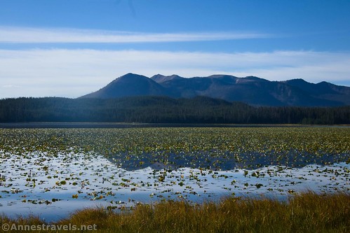
Reach the beginning of the lake after about 1.8 miles. At this point, it looks mostly like a swamp. But I’d expect the wildlife could be good here, so you might want to be quiet as the trail reenters the woods.

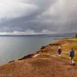
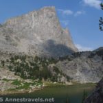
Drop down to the first beach a short distance later. You really don’t need to go any further than this, as the views are excellent and there’s a good chance of seeing birds and waterfowl. I spotted a couple of bald eagles in this area.
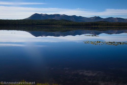
However, if you want to (I did!), you can walk along the lakeshore. Views are spectacular across the lake to Mt. Sheridan. In the stillness of the morning, the reflections were pretty amazing.
Unfortunately, my camera had something on the lens, so my photos aren’t the best. But I did get a few reasonable pictures along the way!

Keep walking on the trail/along the lakeshore. I made it to the point where the lakeshore turns south toward the lake’s outlet (Solution Creek, which flows into Yellowstone Lake). At this point, the beach gives way to brushy banks. I didn’t feel like bushwacking, so I enjoyed a few minutes watching cormorants diving for their breakfast before walking back to the parking area.
On our way back, we met not one but two really nice families. It’s amazing the cool people you can meet out in the wilderness!

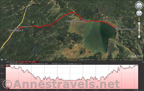
Round Trip Trail Length: I clocked 5.5 miles
Elevation Gain: 491ft. (7,986ft. to 7,916ft.)
Facilities: None
Fees: $35/vehicle to enter Yellowstone National Park, valid 7 days. National park passes & Yellowstone annual passes are honored.

Trail Notes: The lake received its name because, for many years, it appeared that it had no inlet and no outlet. The “riddle” was eventually solved with the discovery of Solution Creek. Any and all fishing in the lake requires a Yellowstone National Park fishing permit (not a Wyoming fishing permit). Early morning and late afternoon are the best times to see wildlife. You’re looking south, so summer is better than winter for taking photos. The lake is about 0.8 miles across, so seeing wildlife on the far side can be a little tricky. While the trail is well over 5 miles in length, it’s not especially hard terrain, making it a favorite for families.
Trail 
![]()
Road ![]()
Signs ![]()
Scenery ![]()
Would I go 100 miles out of my way for this? ![]()
![]()
Overall Rating: ![]()

GPS Coordinates for Riddle Lake
TH: 44.3585120°, -110.5817360° (44°21.51072′, -110°34.90416′ / 44°21’30.6432″, -110°34’54.2496″) (7,990ft.) (0.0)
Beginning of lake: 44.3621180°, -110.5541200° (44°21.72708′, -110°33.24720′ / 44°21’43.6248″, -110°33’14.8320″) (7,927ft.) (1.8)
Beach at end of lake: 44.3588420°, -110.5417700° (44°21.53052′, -110°32.50620′ / 44°21’31.8312″, -110°32’30.3720″) (7,923ft.) (2.61)
Beginning of lake: 44.3621180°, -110.5541200° (44°21.72708′, -110°33.24720′ / 44°21’43.6248″, -110°33’14.8320″) (7,927ft.) (3.46)
End: 44.3585320°, -110.5816660° (44°21.51192′, -110°34.89996′ / 44°21’30.7152″, -110°34’53.9976″) (7,989ft.) (5.48)

The gpx file for Riddle Lake can be downloaded – please note that this and the GPS Coordinates are for reference only and should not be used as a sole resource when hiking this trail.
Download GPX File size: 96.4 KB Downloaded 429 times
(Note: I do my best to ensure that all downloads, the webpage, etc. are virus-free and accurate; however, I cannot be held responsible for any damage that might result, including but not limited to loss of data, damages to hardware, harm to users, from use of files, information, etc. from this website. Thanks!)

Getting to Lewis Lake
From the southern entrance station, drive north 17.1 miles. Turn right into a small parking area (slightly bigger than a pulloff) just before the Continental Divide. A brown sign on the left indicates a Trail Head, while a slightly (very slightly!) larger sign at one end of the parking area is more helpful and states, “Riddle Lake.”
From West Thumb, drive south and then turn left (south) toward Grant Village. After 4.1 miles, turn left into a small parking area (slightly bigger than a pulloff) just after the Continental Divide. A brown sign on the right indicates a Trail Head, while a slightly (very slightly!) larger sign at one end of the parking area is more helpful and states, “Riddle Lake.”
Today’s Featured Product!
For more great hikes in Yellowstone National Park, be sure to check out this book! It also covers nearby Grand Teton National Park and other trails in Wyoming. Buy your copy here!

One response to “Reflections at Riddle Lake!”
[…] and I stopped at Moose Falls again (0.2 miles) for some better pictures. Then I headed up to Riddle Lake (5.5 miles). Early morning is a fantastic time to visit, with a variety of birds, bugling elk, […]