
The very first hike I took in Goblin Valley State Park was Caramel Canyon to the Goblin’s Lair, with the Three Sisters and the Goblette’s Lair thrown in for good measure. It seemed like a good idea to check out the official trails before going exploring, and the very nice ranger at the guard gate said this was a good one. It offers a slot canyon, great views, two caves, and lots of rock formations, so I’d call it well worth the adventure if you have time off from exploring Valley of the Goblins, 1, 2, and 3.
Quick Stats

We started out so early in the morning that the crowds hadn’t shown up yet. We also decided to do Caramel Canyon first. I would recommend this; however, realize that most of the signage is in the other direction (oops!)
From the primitive restroom on the left (as you face the Valley of the Goblins) side of the parking lot, head north (well, northeast) toward the signs. Just after the sign about the history of the San Rafael Swell, a brown floppy post has an arrow that points left. This will take you down toward Caramel Canyon.
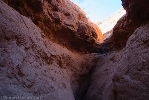
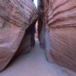
The route is straightforward at first, following a well-defined trail that eventually drops into a wash that deposits you fairly quickly into the Caramel Canyon Wash. Keep heading down the wash. I became confused at the top of the slot, figuring that no self-respecting state park would take hikers down that kind of dryfall into that kind of canyon (as fun as it looked). Well, I was wrong – that’s exactly where the trail goes! After wandering around for a few minutes following social trails and footprints, we headed down the slot canyon to fun and adventures.

The slot does require some scrambling, so be forewarned. However, it’s fun, and going down, none of us had much trouble.
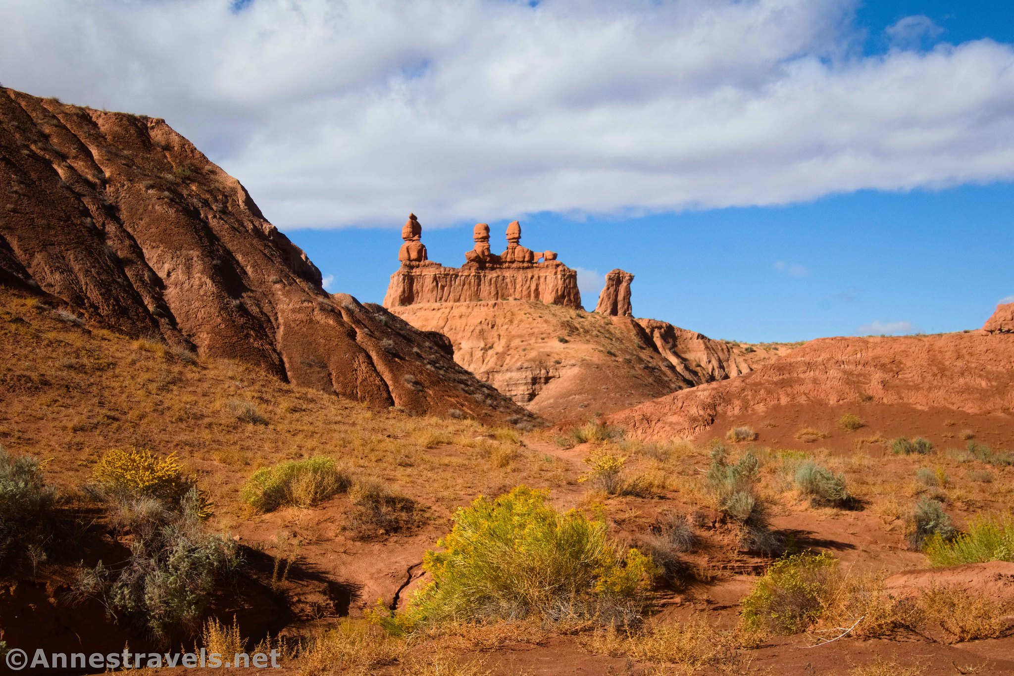
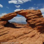
About a quarter mile from the trailhead, the slot widens into a canyon. Keep walking downstream another tenth of a mile to the first sign you’ve seen in a while (we were seriously wondering if we were on any path at all by this point – and yes, it faces the other direction), which points up to the Three Sisters formation. This is a worthy side trek, so turn left up the steep and sandy trail.

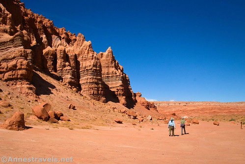
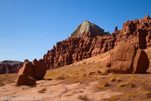
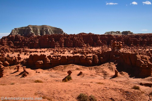
At the top, you can walk all the way around the Three Sisters Formation, which is one of the most iconic rock formations in the park and has great views.

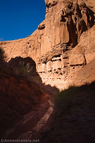
Retracing your steps back down into Caramel Canyon, the views are quite good downstream (and upstream). Once in the canyon (at the sign), turn left to continue down Caramel Canyon, which has mellowed as if to say, “What, me? Be a Class 3 scramble-type of slot canyon? You must be mistaken!”

Be sure to look back at the Three Sisters Formation – in the morning, the light is perfect for great views.
Continue down the canyon another 0.4 miles to a trail junction (this time, the sign is pointing 90 degrees away from you). Turning right (the way the sign faces) would take you back up to the parking lot, and supposedly going left would take you to the visitor center, though that trail seemed hard to find. For now, we want to continue straight, keeping the wall of rock on our right.
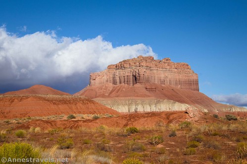
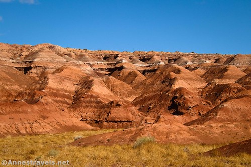
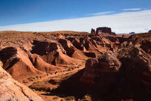
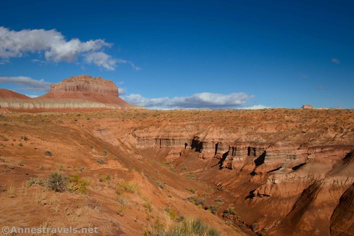
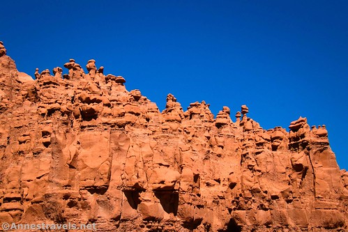
This part of the trail is quite scenic. There are colorful badlands and a cool butte on the left, while the cliffs on the right are topped with small “goblin” formations. While the trail might be vague for part of this route, it’s not too difficult to know where to go (just keep those cliffs on your right!)

About 0.25 miles after the last junction, as sign (facing you more or less this time!) will point that the Goblin’s Lair is to the right (straight, per the sign), while the Goblette’s Lair is ¼ mile to the left. Turn right.
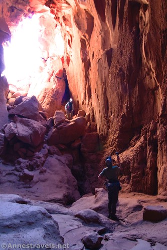
The path up to the Goblin’s Lair is definitely not for the faint of heart. In fact, it’s quite the scramble! Take your time and watch your feet. At the top, a pile of boulders marks the entrance.
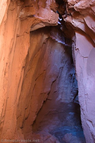
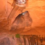
Looking down, I was pretty sure I could scramble down into the Lair. I made it with some sketchy Class 3 scrambling (but then again, I’m no stranger to rock scrambles). Standing inside the lair was incredible, with candle drippings (mud running down the wall from past rains) and a really cool roof, complete with several holes. It was like standing in a cathedral!
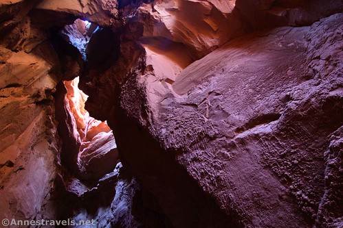
You don’t need a headlamp to explore the Goblin’s Lair – there is plenty of light coming in through the entry and holes in the roof. However, it’s a lot more fun to have one or the flashlight on your phone. We’d been on too many late afternoon hikes recently, so we all still had our headlamps in our packs. Wow!
I’ve heard that the Goblin’s Lair was named Chamber of the Basilisk (mythical European snake that could kill with a single glance) by Kessler and Shaylee, the son and daughter of Scott over on SummitPost, when they repelled from above into the cave back in 2011. Several others picked up the name, and it can be found on the internet. Who exactly started calling it the Goblin’s Lair (or if that was already the name, but Scott and his kids were unaware of it at the time), I don’t know, but the park definitely uses the name Goblin’s Lair.

Scramble back up and out of the Goblin’s Lair, retrace your scramble back down to the main trail, and turn right to find the Goblette’s Lair. Just like the sign says, it’s a quarter mile beyond the sign.

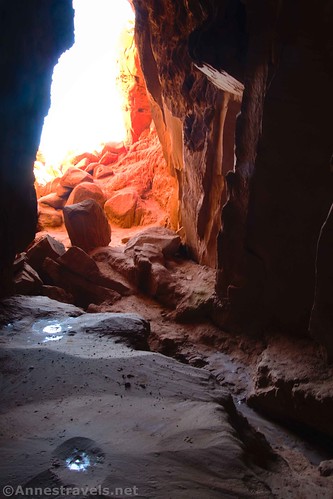
If you thought the trail up to the Goblin’s Lair was sketchy, the trail up to the Goblette’s Lair is worse (IMO). Scrambling, a few boulders, and a few holes in the ground all make it an adventure. Watch those feet, and ignore the trail that goes off on the left partway up.

I was able to scramble down into the Goblette’s Lair, as well. The initial climb over boulders – which you’d need to do anyway to see inside – was the hardest part. I’d say the Goblette’s Lair isn’t quite as mesmerizing as the Goblin’s Lair, but I loved some of the mud formations on the ceiling.
Hike back out and down, retracing your steps to the junction with the sign that points to the Visitor Center, Goblin’s Lair, and Caramel Canyon. Turn left to ascend the wash and then a hill. The views improve as you climb.

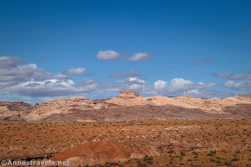
Be careful to stay on the path – it’s not hard to follow, but you may be looking at the scenery more than at your feet. At last, the path reaches more or less the top of the mesa. From here, you can see the Three Sisters, the San Rafael Swell, and the northern end of Valley 1, among other sights.
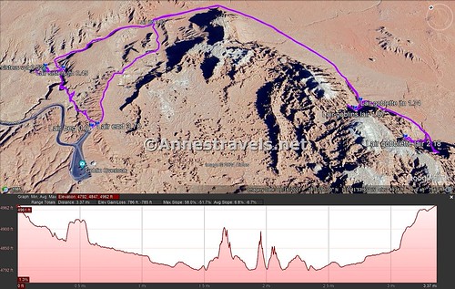
And then, 3.6 miles after starting out, arrive back at the trailhead behind the restrooms. It’s a great way to spend part of a morning or as a slightly more structured hike before or after exploring the Valleys of the Goblins. And it’s not exactly the same kind of scenery you’ll find most other places in the US, so have fun!
Round Trip Trail Length: I went 3.6 miles plus a tenth of a mile looking for the trail around Caramel Canyon
Elevation Gain: My GPS claims 785ft. (4,962ft. to 4,792ft.), but I turned it off before descending into the Lairs.
Facilities: Restrooms, picnic tables, and water in the trailhead parking lot
Fees: $20/vehicle to enter Goblin Valley State Park, valid until 10pm on the day after purchase (in other words, if you enter the park at 8am or 5pm on Thursday, it will be valid until 10pm on Friday). State Park Passes are accepted. An additional fee ($4/person) is charged for repelling into Goblin’s Lair.

Trail Notes: Significant Class 3 scrambling is required for the route described here. To avoid that, go right at the trailhead, bypassing Caramel Canyon completely, and then turn right at the sign for Goblin’s Lair. You’ll have to decide how far up toward or into the lairs you’re comfortable scrambling. The views of the Three Sisters and most of the cliffs are best in the morning, though it would be a fine afternoon hike, as well. Be sure to bring plenty of water and sunscreen as the path is very exposed and hot, especially in the summer.

Trail 
![]()
![]()
Road ![]()
Signs ![]()
Scenery ![]()
Would I go 100 miles out of my way for this? ![]()
Overall Rating: ![]()
GPS Coordinates for Caramel Canyon & the Goblin’s Lair
TH: 38.5653010°, -110.7025750° (38°33.91806′, -110°42.15450′ / 38°33’55.0836″, -110°42’09.2700″) (4,965ft.) (0.0)
Three Sisters Formation Junction: 38.5683630°, -110.7017880° (38°34.10178′, -110°42.10728′ / 38°34’06.1068″, -110°42’06.4368″) (4,880ft.) (0.45)
Three Sisters Viewpoint: 38.5686300°, -110.7023050° (38°34.11780′, -110°42.13830′ / 38°34’07.0680″, -110°42’08.2980″) (4,922ft.) (0.52)
Goblin’s Lair Trail: 38.5688500°, -110.6972470° (38°34.13100′, -110°41.83482′ / 38°34’07.8600″, -110°41’50.0892″) (4,880ft.) (1.02)
Goblin’s Lair Junction: 38.5615640°, -110.6946830° (38°33.69384′, -110°41.68098′ / 38°33’41.6304″, -110°41’40.8588″) (4,866ft.) (1.74)

Goblin’s Lair: 38.5613930°, -110.6954240° (38°33.68358′, -110°41.72544′ / 38°33’41.0148″, -110°41’43.5264″) (4,963ft.) (1.87)
Goblette’s Lair: 38.5599550°, -110.6954110° (38°33.59730′, -110°41.72466′ / 38°33’35.8380″, -110°41’43.4796″) (4,933ft.) (2.18)
End: 38.5652560°, -110.7023990° (38°33.91536′, -110°42.14394′ / 38°33’54.9216″, -110°42’08.6364″) (4,965ft.) (3.70)
The gpx file for Caramel Canyon & the Goblin’s Lair Loop can be downloaded – please note that this and the GPS Coordinates are for reference only and should not be used as a sole resource when hiking this trail.
Download GPX File size: 78.1 KB Downloaded 114 times
(Note: I do my best to ensure that all downloads, the webpage, etc. are virus-free and accurate; however, I cannot be held responsible for any damage that might result, including but not limited to loss of data, damages to hardware, harm to users, from use of files, information, etc. from this website. Thanks!)
Getting to the Caramel Canyon & the Goblin’s Trail Trailhead
From the Goblin Valley State Park Entrance Station, drive south for 0.5 miles. Turn left, following the sign for the Valley of Goblins. The road will end in a parking area 0.7 miles later. The trailhead is on the far left end of the parking lot (away from the pavilion).

If you also need to get to the entrance station: From I-70, take Exit 149 to UT-24. Turn south and drive 24.2 miles (this turn is on the left, 13.3 miles north of Hanksville, if you’re coming from the south). The junction will be signed for Goblin Valley State Park. Drive 5.2 miles, then turn left (stay on the paved road) for 6.4 miles to the entrance station.
Today’s Featured Product!
Explore 255 trail in Utah with this guide! It covers multiple parks, especially in the southern part of the state. Buy your copy here!


Pingback: Sneak Peak: The Rest of the Trip! (SLC, Sawtooths, Utah, Loveland Pass) – Anne's Travels