
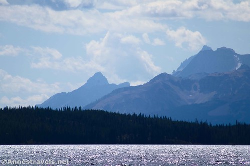
If you need a short, easy hike in southern Yellowstone – but you’d also like a nice view – check out the Lewis River Channel Trail to the lakeshore of Lewis Lake. It’s only 2.8 miles round trip with minimal elevation gain. At the lakeshore, you’ll get views south down Lewis Lake to the distant Teton Mountains as well as nearer mountain peaks.
Quick Stats
Note: Some of the links in this post are affiliate links. If you click one and purchase something, I may earn a small commission without an extra cost to you.

I started out in the middle of my first afternoon in Yellowstone National Park. I didn’t know exactly what I’d find and only hoped that it wouldn’t be too hard since we’d already hiked to Terraced Falls that morning. (I have a bad habit of starting off with crazy hikes on my trips. I’m trying to break that habit, and this may be the first or second trip where I’ve really been successful at not picking a 12-mile, 4,000ft. elevation gain hike at 10,000ft. for our out-of-the-van, just off the 300ft. lake plain, on our first day out.)
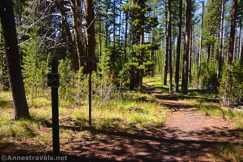
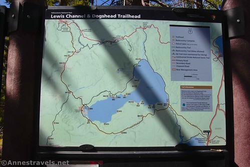
There are two trails that leave from the Lewis Channel Parking Area – Lewis River Channel Trail and Dogshead Trail. Technically, both will take you to Shoshone Lake: the Dogshead Trail, more quickly, and the Lewis River Channel Trail, more scenically along Lewis Lake and then up the Lewis River. You want to take the Lewis River Channel Trail, which is to the left of the more obvious Dogshead Trail (if you find yourself on a straight, gravel path that looks like an old road, you’re on the wrong trail). If you’re having trouble finding the right trail, turn your back to the restroom and walk straight across the parking area. The Lewis River Channel Trail is to the left of the signs.

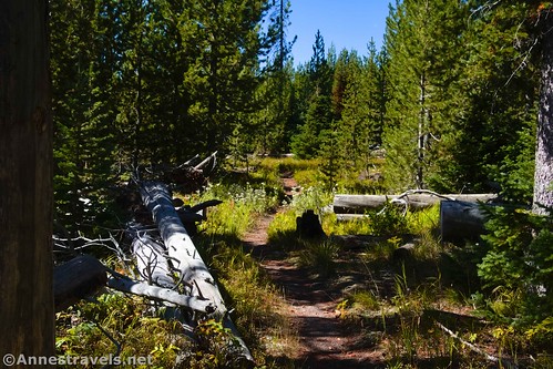
The Lewis River Channel Trail begins by wandering through a pine forest. I’d guess most of this area wasn’t harmed too much by the 1989 fire, though the new growth would suggest that the fire made way for the young trees, too. The path is mostly through meadows and forests. It was a pleasant stroll on an autumn afternoon but could be hot in the summer.

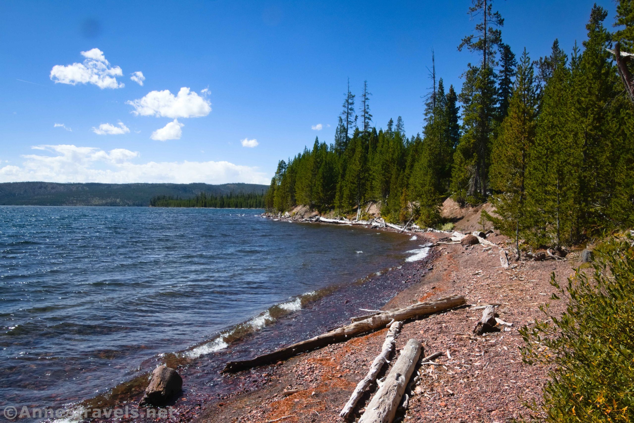
Cross over a (hopefully dry) riverbed, then pick up the trail on the other side to head left (downstream) – technically, if you went right (upstream), you’d end up at the Dogshead Trail. A footbridge once crossed this drainage channel, but it seems to have been missing for a few years. After this, you’ll begin to see Lewis Lake on your left through the trees.
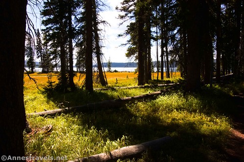
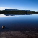
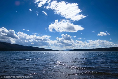
About 1.4 miles from the trailhead, you’ll be able to easily scramble down to the beach on the shore of Lewis Lake via a very short social trail.

Views are very pleasant from the beach if not truly spectacular. To the west (right) are the cliffs leading up to the Pitchstone Plateau. To the east (left) is Factory Hill and the Red Mountains. And to the south (down the lake) is the Teton Range.

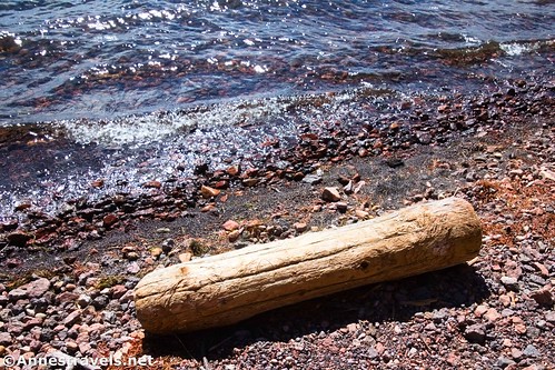
We spent maybe 20 minutes sitting on a log by the lakeshore, having a snack, and enjoying the views. As I said, it’s a very pleasant and peaceful place to hang out for a while.
Return the way you came. You can also keep hiking along the trail to the Lewis River, hike upstream, and then return via the Dogshead Trail – but that’s an 11+ mile trek!

Round Trip Trail Length: 2.8 miles
Elevation gain: 216ft. (7,812ft. to 7,788ft.)
Facilities: Primitive restrooms at the trailhead
Fees: $35/vehicle to enter Yellowstone National Park, valid 7 days. National park passes & Yellowstone annual passes are honored.
Trail Notes: This is fairly easy hike due to the lack of elevation gain. It’s also customizable; if the beach is already occupied, there should be more places to access the lakeshore further down the trail.
Trail 
![]()
![]()
Road
Signs ![]()
Scenery ![]()
Would I go 100 miles out of my way for this? ![]()
![]()
Overall Rating: ![]()
GPS Coordinates for Lewis Lake
TH: 44.3200220°, -110.5996110° (44°19.20132′, -110°35.97666′ / 44°19’12.0792″, -110°35’58.5996″) (7,794ft.) (0.0)
Lakeshore: 44.3227520°, -110.6211030° (44°19.36512′, -110°37.26618′ / 44°19’21.9072″, -110°37’15.9708″) (7,784ft.) (1.43)
End at TH: 44.3201210°, -110.5996780° (44°19.20726′, -110°35.98068′ / 44°19’12.4356″, -110°35’58.8408″) (7,794ft.) (2.83)

The gpx file for Lewis Lake can be downloaded – please note that this and the GPS Coordinates are for reference only and should not be used as a sole resource when hiking this trail.
Download GPX File size: 43.4 KB Downloaded 523 times
(Note: I do my best to ensure that all downloads, the webpage, etc. are virus-free and accurate; however, I cannot be held responsible for any damage that might result, including but not limited to loss of data, damages to hardware, harm to users, from use of files, information, etc. from this website. Thanks!)
Getting to Lewis Lake
From the southern entrance station, drive north 14.3 miles. Turn left into the parking area – a sign marks the trailhead as, “Lewis Channel – Dogshead” with an icon of a hiker. Park in the somewhat convoluted parking area.
From West Thumb, drive south and then turn left (south) toward Grant Village. After 7.0 miles, turn right into the parking area (a sign marks the trailhead as, “Lewis Channel – Dogshead” with an icon of a hiker). Park in the somewhat convoluted parking area.

This Week’s Featured Product!
If you love easy day hikes, Yellowstone has you covered! The park is full of easy hikes to fascinating and beautiful features. Buy this book to learn more about some of the best of these easy hikes!