

Occasionally, I’ll see a picture and instantly think, “If that’s in the US, I’ve got to go there.” Medicine Bow Peak, in southern Wyoming, was one of those pictures. After a single glimpse of the area, I knew I’d be visiting it…and the sooner the better! Since it “just happened” that we were planning on visiting northwestern Colorado within a few weeks, I decided to postpone Colorado for a couple days and have our first trail in Wyoming. (Medicine Bow Peak is only 40 miles (65 km) from I-80, so it wasn’t far out of our way). And, oh, I’m glad I did. The views were spectacular, the wildflowers were glorious, and the trail deserted enough for some adventure. Overall, we actually climbed on/behind two other peaks while getting to Medicine Bow Peak, but, hey, the views were so nice that it was just a really great hike! And, the entire trail was only 7 miles (11 km) long!
Quick Stats
(Affiliate links are present on this page.)
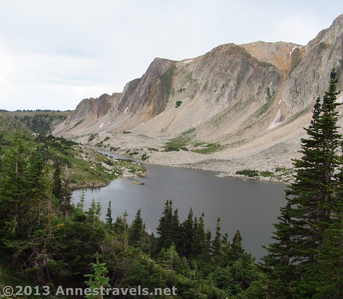
We parked in the West Lake Marie Trailhead parking area, then headed up the steep dirt trail at its eastern end. A paved path also goes off from this end, heading around Lake Marie. I think many people walk on the paved path (or park in the picnic area further up the road and hike from there) rather than take the dirt trail that looks like a well-beaten social path. It would definitely be flatter to hike that way, but you’d miss a lot of the great views. Actually, you’ll be coming back on the paved path, to make a loop, so don’t worry that you’ll miss out too much on the Lake Marie views at this point. (That, and there are some really incredible views of Lake Marie the way you’ll be hiking!)
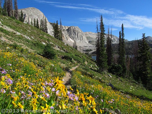
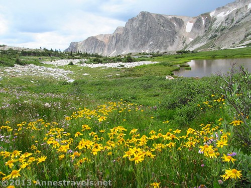
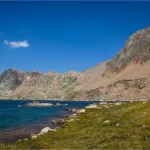
The dirt trail climbs steadily and quickly as it switchbacks up the hillside. In early August, this hillside was covered will beautiful wildflowers. I simply couldn’t resist taking a few shots of the flowers, with Lake Marie in the background. As you climb, keep looking down at Lake Marie. It’s in a pristine setting, with sheer cliffs behind it and more lakes beyond. Keep climbing until you reach an old sign (in pretty bad shape when I was there) pointing toward “Medicine Bow CCC Overlook”. (Or something like that – the sign was only partially readable.) This is a very short side-trail to a pretty view overlooking Lake Marie. Return to the main trail and keep climbing. The trail will now change from dirt to rocky scree. It’s still a fairly easy walk at this point, but do watch your footing.
About 1.5 miles (2.4 km) from the trailhead, the trail begins to flatten out. You’ve now gained the majority of the elevation on the trail. However, the trail from here to Medicine Bow Peak is more rock-in-dirt or rock/scree, so you’ll need to watch your footing.
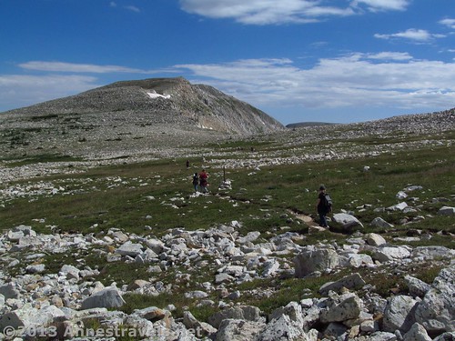
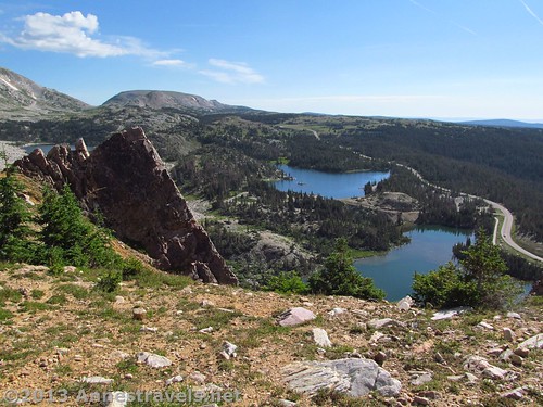
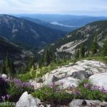
Enjoy the views through the next section, as there is some nice scenery to the west. The trail in this area if often marked by wooden posts sticking out of large rock cairns as it meanders through grassy, rocky tundra. Along the way, a sign will point toward an “old lookout” and “cabin” in 200 ft. (60 m). A few of us checked out this viewpoint; the view is fine (though there’s better elsewhere) and the cabin is fairly unimpressive, so do whatever you want. The next excitement comes when the trail hits its first rock field. The trail all but disappears in a sea of small boulders, except for some erratically placed cairns. Although there are signs, the trail has been moved from one place to another here, so we managed to get off the trail entirely. Once we figured this out, we decided to rock-hop over to the cliff edge for lunch rather than go back to the right trail immediately. (Remember, we were still living on EDT, so lunch comes about 10am MDT!)
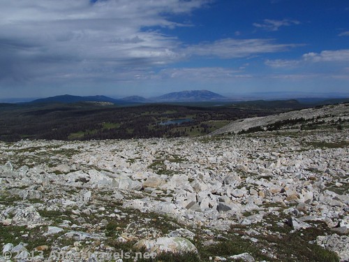
I highly recommend that you also go over to the edge in this area (assuming you’re good at boulder-hopping, don’t mind heights, and can get yourself back on the trail again). The views are beautiful, and there are some really cool shaped rocks along the cliff edge (far enough away to be safe, thankfully!)
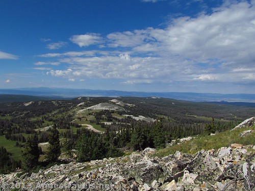
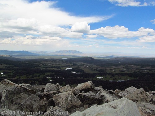
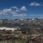
Return to the trail and continue across the rockfield, then through top-of-the-world views and lovely tundra. About 3 miles (4.8 km) from the trailhead, the trail finally comes to the top of Medicine Bow Peak, 12,008 ft. (3,660 m) above sea level, and the highest peak in the Snowy Mountain Range. Enjoy the views here and just after the peak; the views are simply lovely!
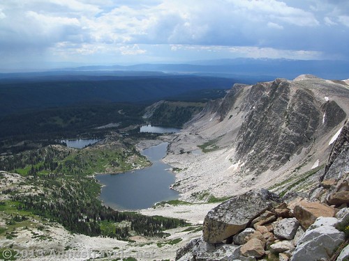
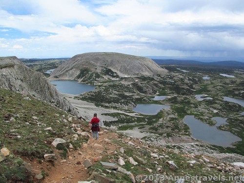
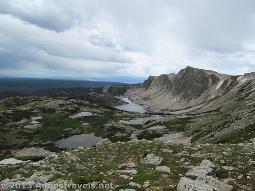
Immediately after Medicine Bow Peak, the trail begins to descend quickly. After a stint across a rock field, the trail becomes dirt and takes some serious switchbacks to descend most of the elevation you’ve gained across the entire rest of the hike. Take some time in this area to look around; the views are beautiful. Below you are numerous large and small lakes; above these rise sheer, light grey cliffs. Around you are other mountains that still had some snow on them in August. It’s spectacular, even if it was clouding over (and a thunderstorm was approaching) by the time we got there!
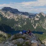
The trail finally stops switchbacking after 0.8 miles (1.3 km) at a trail junction. Turn right here; turning left will take you to the wrong trailhead. You should now be walking along a somewhat rocky trail with the cliffs and lakes on your right. The views here are, again, sublime (alpine meadows, wildflowers, lakes, and cliffs, anyone?) It is also a very peaceful reprieve after the rocks and switchbacks of the rest of the trail.
After 1.8 miles (2.9 km) of hiking beside quiet alpine lakes and through alpine meadows, you will suddenly come out of a stand of trees into what was obviously once a campground (it’s a picnic area now). Probably the simplest thing to do here is to turn left and walk down the road, keeping left at the next two intersections. (We rambled about in the forest for a bit, which I don’t recommend, so I’m giving these directions from a satellite photo.) Not long after the second intersection, there will be a small parking area on the right – a trail should lead from this down toward Lake Marie. Take this trail down, then access the paved walking/biking path and head clockwise (right) around Lake Marie. This path will take you right back to the West Marie Lake Trailhead, where you began your hike.
The Medicine Bow Peaks area is certainly a beautiful one. I’m thrilled that I did it, and I’d definitely go back again someday…and hopefully on a day when thunderstorms aren’t quite so close!
Round Trip Trail Length: 7 miles (11.2 km)
Trailhead Elevation: 10,495 ft. (3,199 m)
Highest Elevation (Medicine Bow Peak): 12,008 ft. (3,660 m)
Net Elevation Gain: 1,513 ft. (460 m)
Facilities: Restrooms at the Lake Marie Trailhead and the Mirror Lake Picnic Area (the former campground). Tables are also available at the picnic area.
Fees: None, currently, though there is talk of instituting a day-use fee at the Mirror Lake Picnic Area.
Trail 
![]()
![]()
![]()
Road
Signs ![]()
Scenery
Would I go 100 miles out of my way for this?
Overall Rating: ![]()
Key GPS Coordinates for Medicine Bow
Parking Area: 41.33134N / -106.32566W (41° 19′ 52.8234″ / -106° 19′ 32.3754″) (10,493ft.; 3,199 m)
Trailhead: 41.33262N / -106.32567W (41° 19′ 57.4314″ / -106° 19′ 32.412″) (10,496ft.; 3,199 m)
CCC overlook: 41.33434N / -106.32973W (41° 20′ 3.6234″ / -106° 19′ 47.0274″) (11,046ft.; 3,366 m)
Viewpoint where we ate lunch: 41.35257N / -106.32652W (41° 21′ 9.252″ / -106° 19′ 35.472″) (11,639ft.; 3,547 m)
Medicine Bow Summit: 41.36028N / -106.31763W (41° 21′ 37.008″ / -106° 19′ 3.4674″) (12,008ft.; 3,660 m)
Medicine Bow Trail/296 Trail Junction: 41.35824N / -106.30894W (41° 21′ 29.664″ / -106° 18′ 32.184″) (11,121ft.; 3,389 m)
Enter campground: 41.33856N / -106.32315W (41° 20′ 18.816″ / -106° 19′ 23.3394″) (10,645ft.; 3,244 m)
Junction with paved path around Lake Marie: 41.335176N / -106.321263W (41° 20′ 6.633″ / -106° 19′ 16.5468″)
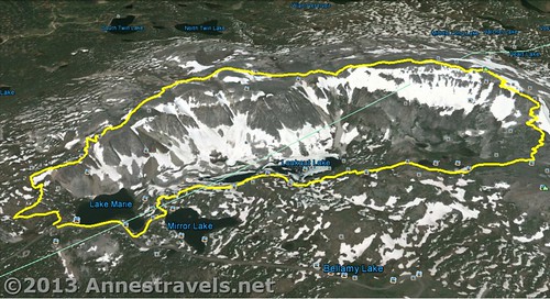
The gpx file for the Medicine Bow Peak Trail can be downloaded – please note that this and the GPS Coordinates are for reference only and should not be used as a sole resource when hiking this trail.
Download GPS File File size: 181.3 KB Downloaded 698 times
(Note: I do my best to ensure that all downloads, the webpage, etc. are virus-free and accurate; however, I cannot be held responsible for any damage that might result, including but not limited to loss of data, damages to hardware, harm to users, from use of files, information, etc. from this website. Thanks!)
Getting to Medicine Bow Peak Trailhead (West Lake Marie Trailhead)
From I-80 in Laramie, WY, take Exit 311 and turn west on WY-130 W (also known as Snowy Range Road). After 0.7 miles (1.1 km), take a right to stay on WY-130 W. Drive another 41.8 miles (67.3 km) (a total of 42.5 miles (68.4 km) from I-80) to the West Lake Marie Trailhead, on the right.
If you’re coming from the northwest, you can also take Exit 235 off of I-80 and turn south on WY-130 E (also known as US-287 S and US-30 W – seriously; this road is named both East and West!) After 28 miles (45 km), and after passing through the “town” of Saratoga, turn left to stay on WY-130 E. The parking area will be on the left 26.2 miles (42.2 km) later.
If you’re coming from the south, from the town of Walden, CO, drive 13 miles (21 km) north on CO-125 N. Stay left to continue on CO-125 and drive another 8.8 miles (14.1 km). Here, at the Wyoming boarder, the road changes names to WY-230 W. Continue another 27 miles (43.4 km), then turn right to stay on WY-230 W for another 10.1 miles (16.2 km). Turn right onto WY-130 E; the parking area for the West Lake Marie Trailhead will be on the left 26.2 miles (42.2 km) later.
Please note that the trailhead may not be marked – it is simply at the western end of Lake Marie, has a paved path running to it, and has a prominent primitive toilet.
This Week’s Featured Product!
This Falcon Guide goes well beyond Yellowstone National Park to showcase some of Wyoming’s best hiking opportunities. Hikes across the state vary, from short walks to pretty lakes to 50+ mile backpacking routes through the state’s rugged Wind River Range. Medicine Bow Peak is included in the guide.


3 responses to “Serene Lakes, Wind-swept Cliffs: Medicine Bow Peak Loop”
[…] Hiking is an activity many Wyomingites and visitors to the Cowboy State find to be relaxing and peaceful. The scenery can be breathtaking! […]
[…] saw pictures of the Medicine Bow Range in Wyoming and knew we had to do that […]
[…] goal in visiting the Snowy Range in southern Wyoming was to hike the trail up to Medicine Bow Peak. That was an amazing hike, but looking for a place to eat breakfast early on the morning of the […]