

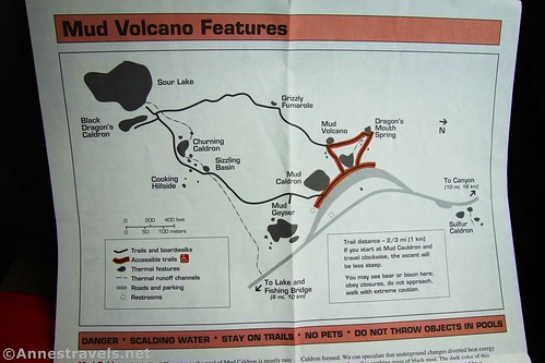
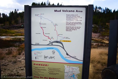
The Mud Volcano Area of Yellowstone National Park has one of my favorite non-colorful hot spring, non-geyser geothermal features in the park. It also has some other cool geothermal things to see, most of which are more violent than pretty to look at. The entire boardwalk is less than a mile RT, so if you happen to be passing by, it’s worth a quick stop.
Quick Stats
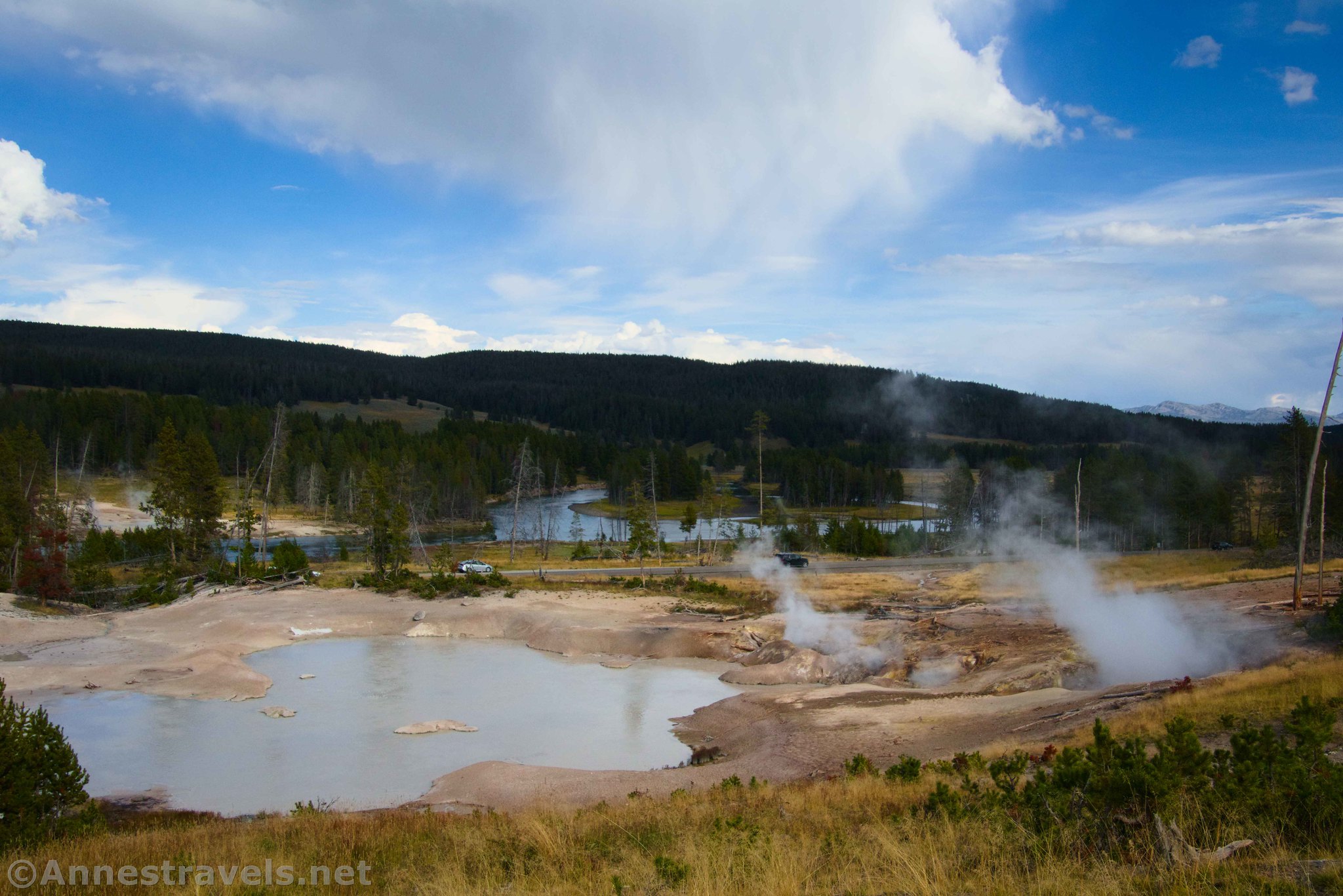
Before we went to the Mud Volcano Area on storm-threatening afternoon, we stopped at the nearby Sulphur Caldron. This is just north of the Mud Volcano parking area (many people walk between the two via the crosswalk and sidewalk) on the other side of the main park road.
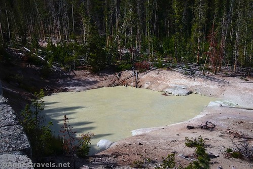
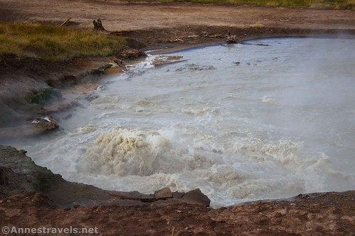
A few signs talk about the features in and around the Sulphur Caldron, which is one of the most acid springs in the park, with a pH of 1-2 – about the same as battery acid.
From the viewing area, you can also see Turbulent Pool and other features.
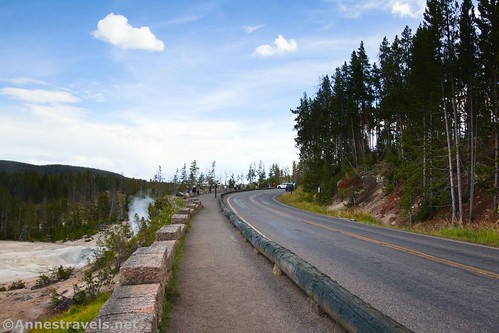
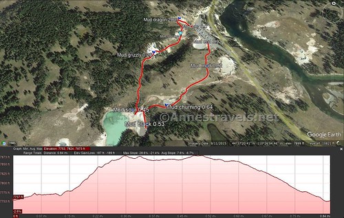
After we read the signs, we drove down to the Mud Volcano parking area. I started at the north trailhead (right as you face the hillside with your back to the parking area) – there are three trailheads; the north (which is where I started), the south (which is where I returned; it’s near-ish the restrooms), and the middle (which is the return trail if you don’t want to climb the hill or have mobility issues).
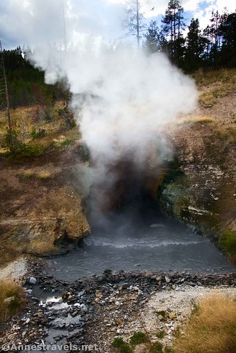
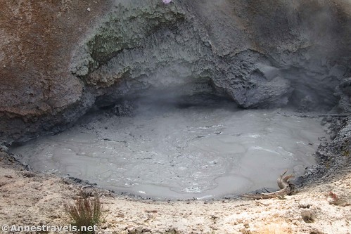
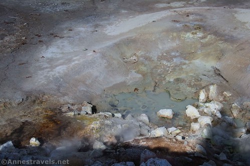
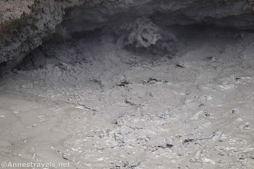
The north trailhead rises gently for 300ft. up to my favorite feature in the area, and also one of the coolest non-colorful or geyser features in the park: Dragon’s Mouth Spring. It’s so cool to see the “dragon’s breath” (water vapor) emanate from the cave!
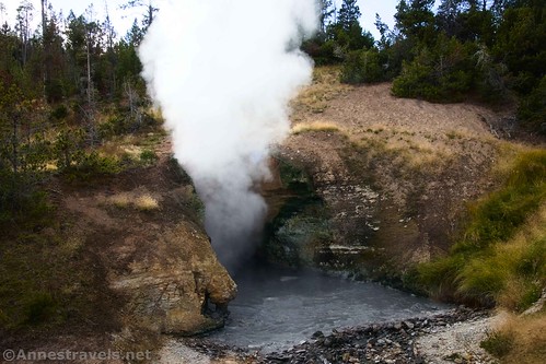
The water also swirls and washes in waves out of the cave, as though the dragon is shifting in its sleep. It’s just so visual. Until 1994, the activity was much more violent, often splashing water onto the boardwalk. Even yet, you can hear the rumbling of the dragon’s snores – or maybe just gas and steam causing the water to splash against the caves beneath the spring – inside of the cave.
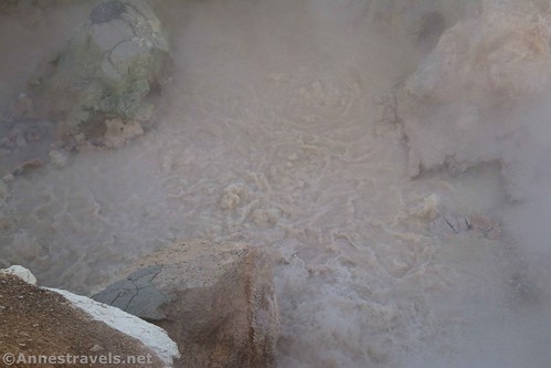
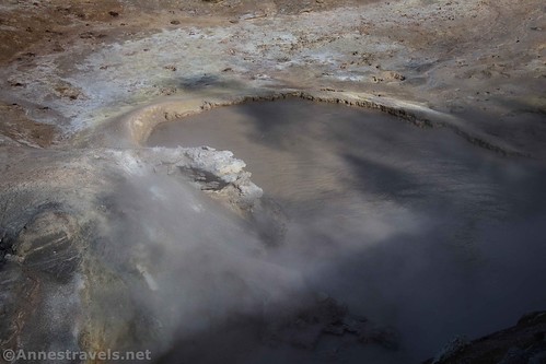
After you’ve enjoyed the spectacle, keep walking along the boardwalk. Pass the Mud Volcano – which is just a churning mudpot at this point. In the late 1800s, the spring would erupt violently, spewing mud all over the nearby trees.
Near this point, you can choose to turn left to return to the parking area (easy, wheelchair-accessible experience) or to continue right up the hill for more geothermal adventures. You can easily guess which way I turned.
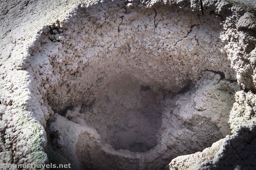
Partway up the hill, about mile 0.25, is Grizzly Fumarole – this is more active in the spring, when the ground is wetter, though we could hear a faint growl within the earth.

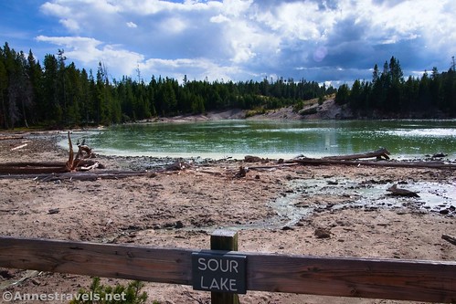
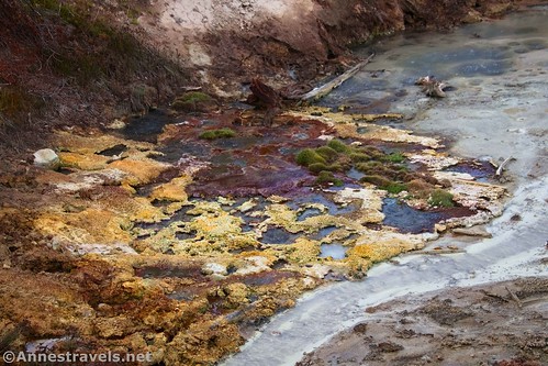
The trail rises up to the top of the hill to a junction. Turn right to view Sour Lake. The water is extremely acidic due to microorganisms that love the high sulphur levels in the area. Otherwise, it’s a quiet lake with a few gentle springs in its depths.
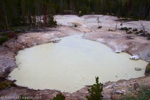
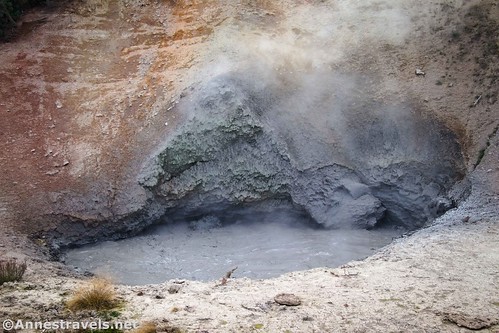
Keep walking around the loop a short distance to the short path on the right to Black Dragon’s Caldron (you’ve gone about half a mile at this point). The Dragon’s Mouth Cave was named c.1912 by a park visitor, so it was natural for this to follow a similar naming scheme when this pool suddenly exploded in 1948. For decades, it continued to blow black mud high into the air.
Now 200ft. away from its original source, it’s relatively mild – if you can call the churning, bubbling caldron of gray mud “mild!”
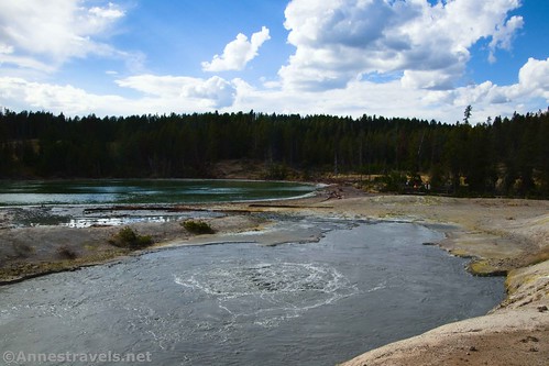
Beyond the Black Dragon’s Caldron, the boardwalk begins its descent back to the parking lot. Churning Caldron is about a tenth of a mile from Black Dragon’s Caldron.
Then comes Sizzling Spring, which really does sound like a frying pan full of eggs and bacon!

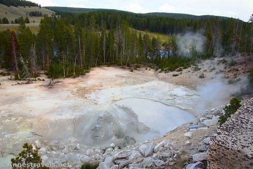
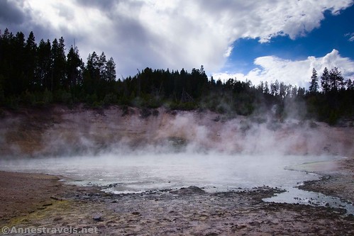
Two tenths of a mile after Churning Caldron, a viewpoint looks down on Mud Caldron (not to be confused with the Mud Volcano or the Mud Geyser, which you’ll see in a minute) on the right. Until 1978, the area around the geyser was forested, but now… well, it’s definitely a devastated area, best appreciated from above.
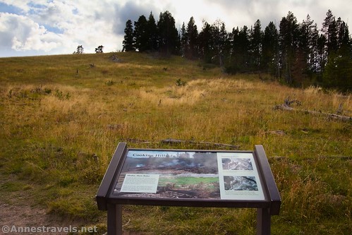
Continue down the boardwalk to pass by the “Cooking Hillside” – the ground in this area around 1978 was so hot (about 200F) that people claimed they could cook eggs on a skillet just set on the dirt (don’t try this – I’m sure it’s illegal, and the ground is much cooler now). The temperature of course killed the trees in the area. So now it’s pretty much just a sparsely grassy meadow.
The boardwalk reaches the parking area 0.9 miles after leaving from the northern trailhead. Nearby, the Mud Geyser (as you walk back toward the northern trailhead) is also impressive!
Round Trip Trail Length: 0.9 miles (near-loop)
Elevation Gain: 189ft. (7,753ft. to 7,873ft.)
Facilities: Vault toilets
Fees: $35/vehicle, valid 7 days. America the Beautiful National Parks & Federal Lands passes and Yellowstone Annual Passes are accepted.
Trail Notes: The entire 0.9 miles of this hike is on boardwalks; however, stairs and steep grades make the southern portion of the hike unsuitable to wheelchairs and those with mobility issues. None of the features in the Mud Volcano Area are what I’d call “pretty.” Several are fascinating for one reason or another, but if you want beauty, try the West Thumb Geyser Basin, Biscuit Basin, or (my favorite) the Upper Geyser Basin. As always in a geothermal area, you must stay on the boardwalk at all times.
Trail 
Road ![]()
Signs
Scenery ![]()
![]()
![]()
Would I go 100 miles out of my way for this? ![]()
![]()
Overall Rating: ![]()
GPS Coordinates for the Mud Volcano
Northern TH: 44.6248900°, -110.4337890° (44°37.49340′, -110°26.02734′ / 44°37’29.6040″, -110°26’01.6404″) (7,761ft.) (0.0)
Dragon Spring: 44.6252150°, -110.4347410° (44°37.51290′, -110°26.08446′ / 44°37’30.7740″, -110°26’05.0676″) (7,790ft.) (296ft.)
Grizzly Fumarole: 44.6231850°, -110.4356490° (44°37.39110′, -110°26.13894′ / 44°37’23.4660″, -110°26’08.3364″) (7,851ft.) (0.26)
Sour Lake: 44.6207650°, -110.4359660° (44°37.24590′, -110°26.15796′ / 44°37’14.7540″, -110°26’09.4776″) (7,869ft.) (0.45)
Black Caldron: 44.6203440°, -110.4352450° (44°37.22064′, -110°26.11470′ / 44°37’13.2384″, -110°26’06.8820″) (7,879ft.) (0.53)
Churning: 44.6210980°, -110.4345360° (44°37.26588′, -110°26.07216′ / 44°37’15.9528″, -110°26’04.3296″) (7,858ft.) (0.64)
Mud Volcano: 44.6229770°, -110.4329390° (44°37.37862′, -110°25.97634′ / 44°37’22.7172″, -110°25’58.5804″) (7,786ft.) (0.82)
End at southern TH: 44.6241820°, -110.4330160° (44°37.45092′, -110°25.98096′ / 44°37’27.0552″, -110°25’58.8576″) (7,758ft.) (0.92)
Sulphur Caldron parking area: 44.6268591°, -110.4326272° (44°37.61155′, -110°25.95763′ / 44°37’36.6928″, -110°25’57.4579″)
Sulphur Caldron viewpoint: 44.6279617°, -110.4333372° (44°37.67770′, -110°26.00023′ / 44°37’40.6621″, -110°26’00.0139″)
The gpx file for the Mud Volcano Area can be downloaded – please note that this and the GPS Coordinates are for reference only and should not be used as a sole resource when hiking this trail.
Download GPX File size: 26.4 KB Downloaded 395 times
(Note: I do my best to ensure that all downloads, the webpage, etc. are virus-free and accurate; however, I cannot be held responsible for any damage that might result, including but not limited to loss of data, damages to hardware, harm to users, from use of files, information, etc. from this website. Thanks!)
Getting to the Mud Volcano and Sulphur Caldron Trailhead
From Canyon Junction, head south (toward Fishing Bridge and West Thumb) on the main park road. After 9.5 miles, turn right into the parking area for the Mud Volcano. The parking area for Sulphur Caldron is on the left just before this turn.
From Fishing Bridge, drive north (toward Canyon) on the main park road. After 5.8 miles, turn left into the parking area for the Mud Volcano. Note that the parking area for Sulphur Caldron is on the right almost immediately if you keep driving toward Canyon.
More Hikes in Yellowstone!
Check out some of the best trails in the park with this guide! It covers almost 50 hikes in Yellowstone and Grand Teton National Parks. Buy your copy here.


One response to “Mud Volcano Area & Sulphur Caldron”
[…] Forest Service Campgrounds, so I convinced my group to stop at Sulphur Caldron (0.1 miles) and the Mud Volcano (0.9 miles) on the […]