

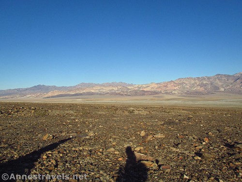
Death Valley is known for its rugged landscape, extreme heat, and desert beauty. What it’s not known for is its accessibility. I’ve read that there is only one fully wheelchair accessible trail in the park (and, at the time of this writing, it’s closed due to hurricane damage). So in this guide, I’d like to help you discover more than just one trail in 2 million acres that can be explored with a wheelchair.
David Fulmer

Need to Know
Death Valley National Park charges a $30/vehicle entrance fee. America the Beautiful National Parks & Federal Lands Passes and Death Valley Annual Passes are accepted. If you are permanently disabled, apply at the visitor center for a free pass to the park.

Visitor Centers, Lodging, etc.
In general, the visitor centers (Furnace Creek, Stovepipe Wells, and Grapevine) are fully accessible, including the museum at the Furnace Creek Visitor Center. So are the pit toilets scattered around the park (classic government-issued models). Lodging tends to be accessible, though check with the owners before you book – a few cabins, etc., are rugged even for hikers!

Furnace Creek Campground offers a limited number of sites and restrooms that are fully accessible. Sunset Campground and Stovepipe Wells Campground offer accessible parking but no designated accessible sites. All of the campgrounds I’ve visited have accessible restrooms (even if they’re just pit toilets).

Wheelchair Accessible Viewpoints
Most official viewpoints are accessible enough to be enjoyed from a wheelchair or from the comfort of your car. Here are a few of my favorites.
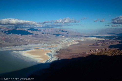
Dante’s View
The trail at Dante’s View isn’t exactly wheelchair-friendly, but the views from the accessible viewpoint adjacent to the parking lot are stunning! (The Dante’s View Road is pretty scenic, too.)

Devils Golf Course
Devils Golf Course can mostly be enjoyed from your vehicle, including the views back to the Black Mountains and across the valley to the Panamint Mountains. If you’re able to walk a short distance or don’t mind the unpaved parking lot, you might want to get out and see the salt formations closer up.

Rhyolite
While the area is not paved, many say that Rhyolite (located just outside of Death Valley National Park) is wheelchair-friendly. At the very least, you should be able to drive through the ghost town.

Ubehebe Crater
The Ubehebe Crater Trail is loose and difficult to walk, but the viewpoint near the parking area is very beautiful. The road up to the crater also has nice views.
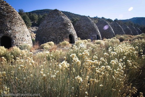
Wildrose Charcoal Kilns
Drive up to the Charcoal Kilns and enjoy a much cooler-than-the-valley part of the park (I’ve found mountain wildflowers like lupine growing up here). The path around the kilns isn’t paved, but it is flat and you can also view the kilns from the gravel parking area.
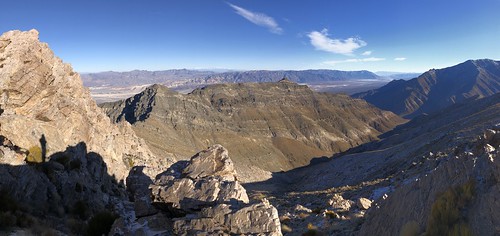
Aguereberry Point
You’ll need high clearance to drive up to Aguereberry Point, but the views from the parking area at the end are amazing!
Father Crowley Vista
With beautiful views down on Rainbow Canyon, Father Crowley Vista is a great stop in the western part of Death Valley National Park.

Wheelchair Accessible Trails
As I said above, only one trail in the park is officially wheelchair accessible. These other options are paved or hard-packed gravel, but they may contain steep grades or other obstacles.

Zabriskie Point
The path to Zabriskie Point is paved, but it’s also quite steep. If you can make it up (and down!), the views are spectacular over the nearby badlands, Manly Beacon, Badwater Flats, and the Panamint Mountains across Death Valley.

Badwater Basin
A somewhat steep ramp leads down to the boardwalk out onto the Badwater Salt Flats (which are hard-packed but may be pock-marked with holes). The coolest part? You get to be at the lowest point in North America!
Bike Path
The Bike Path is not very exciting, as it simply goes 1 mile between the Furnace Creek Visitor Center and the Harmony Borax Works – a distance that could just as easily be driven. But it is paved.
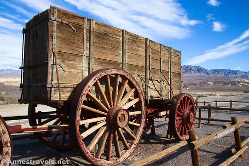
Harmony Borax Works
The packed gravel path leads around the historic Harmony Borax Works and to wagons used by the famous 20 Mule Team. There are a few grades, but these are mostly gentle.

Keane Wonder Mill
While technically the Keane Wonder Mill could be accessed by a wheelchair, the extremely steep grade at the trailhead would make me cautious to try it. The path is packed gravel.

Salt Creek
Salt Creek is the one and only official wheelchair accessible trail in Death Valley National Park. The boardwalk travels to salt marshes which contain rare native fish and other wildlife.

Scenic Drives
What Death Valley lacks in the way of accessible trails, it makes up for with great scenic drives (even the main roads in the park are scenic). Some are paved, some are unpaved, and some require high clearance or 4×4.
Roads Accessible to Most Vehicles
The paved roads are usually accessible, but after wet weather, the dirt roads are typically too muddy to drive except with 4×4. Check at the visitor center for current conditions.
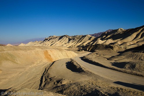
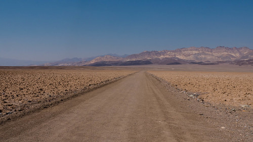
20 Mule Team Scenic Drive
One of my favorite scenic drives in Death Valley, 20 Mule Team is beautiful at any time of day, but especially within a few hours of sunrise or sunset (the road closes at sunset). The dirt road (usually ok for most vehicles) follows the route once used by the famous 20 Mule Borax Team.

Badwater Road
Yes, it’s just a normal park road. But the Badwater Road is beautiful! Enjoy views of the Black Mountains, Panamint Mountains, Badwater Salt Flats, and much more.

Artists Palette Scenic Drive
The twisting, snaking Artists Drive passes through colorful badlands. Be sure to take in the Artists Palette Viewpoint, too.
Mustard Canyon
Mustard Canyon is off of the road for the Harmony Borax Works. The canyon walls are a brownish-yellow, thus its name.

Historic Stovepipe Well Road
This is just a quick gravel road off of the North Highway, leading to the site of the Historic Stovepipe Well. So the story goes, the well was located at the junction of two ancient paths/roads. Sand from the nearby Mesquite Dunes would often blow into the area, obscuring the well from sight, so an industrious traveler marked it with a stovepipe. Today, the well is little more than an old pump and a historic sign.

Daylight Pass Road
I almost didn’t include the Daylight Pass Road, since it’s just one of the roads into and out of Death Valley, but it is truly scenic, especially in the later afternoon or morning.
CA-190
Yes, this is the main road through the park. It’s quite scenic, however (especially the mountain passes!), and worthy of driving if for no other reason than to get from one place to another. I’ve broken this up into sections: Death Valley Junction to Furnace Creek; Furnace Creek to Stovepipe Wells; and Stovepipe Wells to the Western Border
High Clearance & 4×4 Roads
Remember, these roads will be impassible after wet weather. Check at the visitor center for current conditions.

Greenwater Valley Road
High clearance is required for this scenic drive between two mountain ranges. The Greenwater Valley Road also allows access to other roads, especially those accessing the sites of tent cities set up during various mining booms.
Hole in the Wall Road
This is just a scenic road. High clearance is required up to the Hole in the Wall; beyond this, 4×4 is necessary due to deep gravel. The scenery on a morning in November was much more beautiful than I would have imagined!
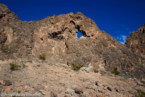
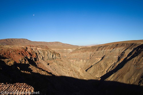
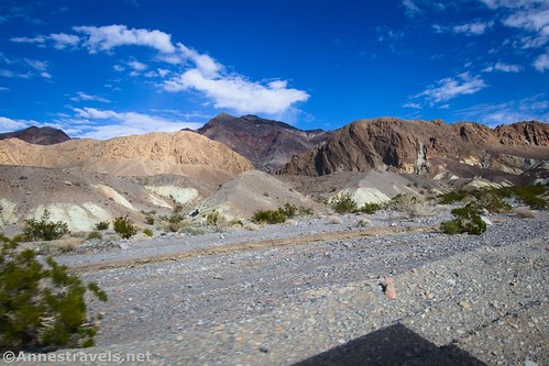
Echo Canyon Road
The 4×4 road ascends through a fascinating canyon (and past an arch) to a valley high in the Funeral Mountains and the site of the Inyo Mine (not exactly wheelchair accessible, though you can see much of it from the parking area). I truly enjoyed driving the Echo Canyon Road.
West Side Road
The West Side Road tends to be high clearance-friendly with great views of Badwater Flats and the Black Mountains. There are also some interesting attractions along the way, including several 4×4 roads that penetrate deep into the Panamint Mountains.
Chloride City Road
Take a historic mining road up to one of the earliest mining areas in Death Valley. Little remains of Chloride City, and what is there is mostly viewable from the road.

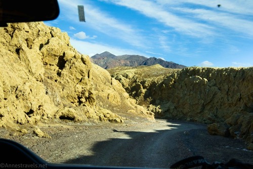
Titus Canyon Road
Some consider Titus Canyon Road to be one of the premier attractions in Death Valley National Park. It travels for miles through the Grapevine Mountains, finally winding its way through a narrow canyon. Leave yourself enough time to see Leadfield (a ghost town that, while not really wheelchair accessible, is viewable from the parking area).

Racetrack Road
Put on your heavy-duty tires for this one! The famous Racetrack Road is filled with sharp rocks, but the views once you reach the playa are also excellent. Stop at the parking area for the Grandstand (good views even from the parking area) before driving down to the parking area for the sailing stones. (Sadly, neither of these is a wheelchair-accessible hike.)
If you know of any other great wheelchair-accessible destinations in Death Valley, please tell me about them in a comment!
Today’s Featured Product!
If you love taking photographs, get a heads-up and head-start with this book! It takes you through Death Valley National Park discussing where and how to get the best photos. Buy your copy here!

More Related Posts:
 Death Valley Road Trip Hiking Itineraries!
 The Best Hikes for Kids in Death Valley National Park!
 Sneak Peak: Petrified Forest, Southern Utah, and Death Valley!
 Sneak Peak: Grand Canyon, Southern Utah, and Death Valley!
 Death Valley, Grand Canyon, Canyonlands… and a Lot of Off-Trail Adventures!
 The Best Dog-Friendly Hikes in Death Valley National Park