

Beauty may be in the eye of the beholder, but to me, Trappers Lake in the Flat Tops Wilderness Area is stunning. In fact, hiking on the Flat Tops around the lake is beautiful, as we found when we hiked up Amphitheatre Peak and then over toward Himes Peak one day in mid-August. Staying near the high cliff edges, you can look down on pretty lakes and streams as well as cliffs on the other side of the valley and across the Flat Tops beyond. Staying away from the cliffs, you get views of the grassy Flat Tops, some nice little ponds/lakes, and the high point of Trappers Peak (12,002 ft.; 3,657 m) In terms of views, you really can’t go wrong! In this post, I’ll detail hiking up Amphitheatre Peak, and in next week’s post I’ll talk about hiking toward Himes Peak. The whole hike was about 10 miles (16 km) RT; for whatever reason, hiking only to Amphitheatre Peak and back would be a similar distance.
(Affiliate links are present on this page.)
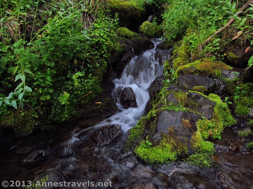
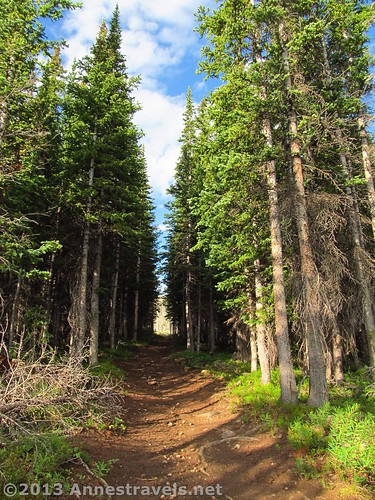
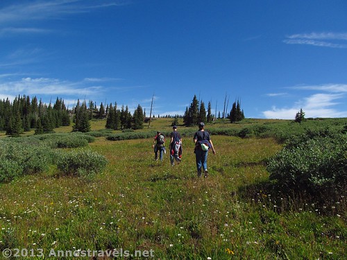
We began our hike up Amphitheatre Peak very early one morning, well-knowing that we’d be facing clouds (if not thunder storms) later in the day. (August is not the best time to visit Colorado!) The trail began next to the signboard in the parking area; follow the signs for Trail #1818 Wall Lake Trail. At first, the trail wondered through a pine forest, winding its way through a burnt out section and around some swampy areas before beginning its real ascent after about a mile (1.6 km). At 0.7 miles (1.1 km), you’ll come to a junction with the Carhart Trail (#1815); stay right and continue on the Wall Lake Trail (#1818). After another mile (1.6 km), you will come to a grove of pine trees we dubbed “The Avenue”. In this small area, the trees have clustered around the trail to form a perfect “gateway” for you to hike through. Fun!
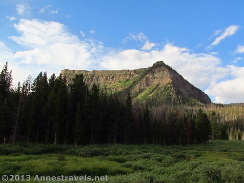
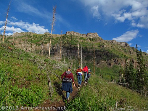
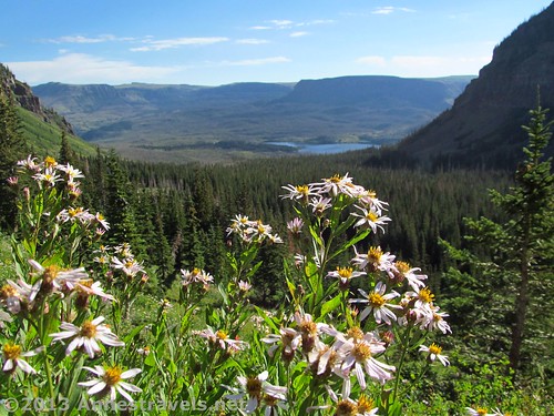
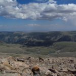
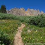
The higher the trail climbs, the more views come into focus. Above you are the cliffs that separate the Flat Tops from the lowlands; keep turning around, also, since as you climb the views of Trappers Lake and the surrounding area will get better. We paused on one of the final switchbacks to admire the view and the wildflowers that were still growing near the trail. This section of the trail is somewhat rocky, but it’s still not a difficult hike – if you can call hiking steeply upward at over 10,000ft. (3000 m) easy! It’s about 1,570 ft. (480 m) elevation gain from the parking area (9,801ft.; 2,987 m) to the top of Amphitheatre Peak (11,368ft.; 3,465 m).
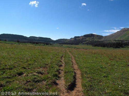
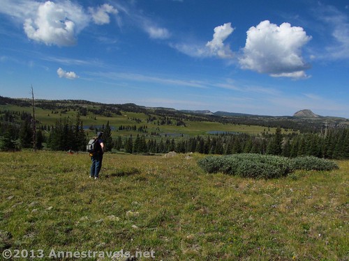
Then, at 3.2 miles (5.1 km), you finally crest the edge of the Flat Tops. You are immediately at a trail junction; Wall Lake Trail (#1818) is the way you came and to the left; to the right is the Oyster Lake Trail (#1815). For now, go left. There are quite a few rocks to sit on at this junction, so if you need to wait for other group members, this is a good place to do it. However, if you walk even a short ways down the trail, the views get better. Nearby is a small pond (unnamed, to my knowledge); beyond are the Flat Tops proper and Trappers Peak. The view opens up and continues to be stunning (in my idea of beauty, I suppose!). The trail is now quite flat; it is a bit more vague here but appears to be followable all the way to Wall Lake.
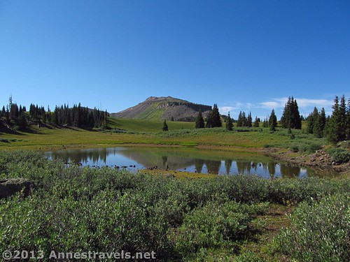
We walked for a bit, then sat on some rocks to eat a snack. About 0.5 miles (0.8 km) after the last trail junction, we decided to turn left off of the trail and head up Amphitheatre Peak, which we knew was in that general direction. Many small trails lead this way; choose one if you want or trust your sense of direction – I highly recommend a GPS and/or a compass and a map so if you do get lost you’ll be able to find your way back. If you don’t know where you are, all you have to do is head southwest and you should be able to find the Wall Lake Trail again. As you’re walking, you may notice a nice peak nearby – this is not Amphitheatre Peak; it is a false summit. You will need to get to the very edge of the cliff to find Amphitheatre Peak.
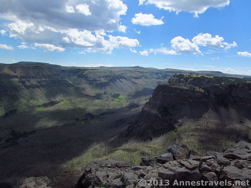
Amphitheatre Peak has two “arms” that extend toward Trappers Lake. We generally headed for the middle, ending up on the cliff edge with an outstanding view of the lake and surrounding area. From here, a vague social trail heads right along the cliff edge toward the eastern arm and the highest point on the peak. Actually, Amphitheatre Peak is an unofficial name for the high point – on topo maps it is simply known as Point 11369. The peak was named for the natural “Amphitheatre” on the southeastern side of the mountain. The video below was taken along the ridge between the two arms.
Keep walking along the edge (or a bit south of the edge – there is quite a bit of scrub and trees along the edge and meadows behind, so we opted to hike in the meadows rather than the scrub) until you reach the place where the other arm extends out above the cliff edge. There is a rocky place here to sit and enjoy the view. Congratulations; this is the top of Amphitheatre Peak!
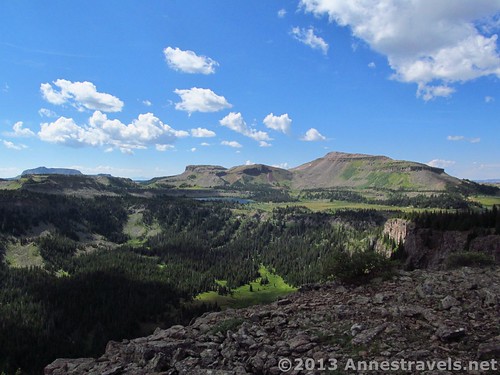
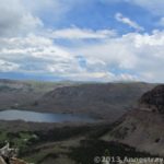
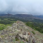
Looking north, we could see Trappers Lake, the Lost Lake Peaks, and any number of small lakes. To the northeast is the Chinese Wall and some really nice views of the Flat Tops above. The Causeway is in this direction, although you can’t see it from here. To the east are the Fraser Creek Drainage and more cliffs. Closer to you and more southeast is the amphitheatre for which the peak was unofficially named. Southward is Wall Lake (very noticeable because of the large wall behind it), Trappers Peak, and classic Flat Tops scenery. It’s difficult to see to the southwest and west from here (due to trees) but if you could, you would see more classic Flat Tops scenery and plenty of small ponds and lakes. To the northwest, you can see Himes Peak and a bit of the side canyon you climbed up to get here.
We decided that we didn’t want to retrace our steps along the cliff edge, so we headed straight down (south and west) back toward the Wall Lake Trail. Pretty quickly, we discovered a social trail headed in the right direction which took us right back to the trail. Nice! From here, you can either turn left and go to Wall Lake (about 0.7 miles (1.1 km) away), or you can retrace your steps back to the Oyster Lake Trail and then back to your vehicle.
Bottom Line on Amphitheatre Peak: If you love the Flat Tops and don’t mind some off-trail travel, this is a hike for you. Start early, though, as even when we were eating lunch on top of the peak the clouds were rolling in for (what thankfully wasn’t) afternoon thundershowers.
Round Trip Trail Length: About 10 miles (16 km)
Facilities: None. If you want restrooms, you’ll have to go to one of the nearby campgrounds. Note that there is basically no free-range camping allowed anywhere near Trappers Lake. We ended up spending the night in one of the campgrounds – which, by the way, have extremely varied fees (we saw everything from $12 to $22 for exactly the same services within a mile (or km) of each other!)
Elevation Gain/Loss: About 1,570ft. (480 m)
Fees: None other than camping fees in campgrounds.
Trail 
![]()
![]()
![]()
Road ![]()
![]()
Signs ![]()
![]()
Scenery
Would I go 100 miles out of my way for this?
Overall Rating: 
![]()
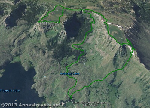
Key GPS Coordinates for Amphitheatre Peak
Parking Area: 39.990559N / 107.243316W (39°N 59′ 26.0118″ / 107°W 14′ 35.937″)
Trail Beginning: 39.99046N / 107.24319W (39°N 59′ 25.6554″ / 107° 14′ 35.4834″) (9,801 ft.; 2,987 m)
Wall Lake Trail Carhart Trail Junction: 39.98307N / 107.24419W (39°N 58′ 59.0514″ / 107°W 14′ 39.084″) (9,833ft.; 2,997 m) 0.7 miles (1.1 km)
“The Avenue”: 39.97664N / 107.25176W (39°N 58′ 35.904″ / 107°W 15′ 6.336″) (10,253 ft.; 3,125 m) 1.7 miles (2.7 km)
Wall Lake Trail / Oyster Lake Trail Junction: 39.96445N / 107.25716W (39°N 57′ 52.0194″ / 107°W 15′ 25.7754″) (11,017ft; 3,358 m) 3.2 miles (5.1 km) on the way out; 6.6 miles (10.6 km) on the way back
Leave the Wall Lake Trail: 39.96108N / 107.25050W (39°N 57′ 39.888″ / 107°W 15′ 1.8″) (11,066ft.; 3,373 m) 3.7 miles (6.9 km)
Nice view over Trapper’s Lake: 39.97053N / 107.24631W (39°N 58′ 13.9074″ / 107°W 14′ 46.7154″) (11,291ft.; 3,441 m) 4.4 miles (7 km)
Amphitheatre Peak: 39.96851N / 107.23965W (39°N 58′ 6.636″ / 107°W 14′ 22.7394″) (11,363ft.; 3,463 m) 4.9 miles (7.8 km)
Rejoin the Wall Lake Trail: 39.95811N / 107.24878W (39°N 57′ 29.1954″ / 107°W 14′ 55.6074″) (11,027ft.; 3,361 m) 5.9 miles (9.5 km)
(All GPS coordinates are correct to the best of my knowledge; however, they should not be used as a sole resource when hiking. Always carry a map of the area, a compass, and trail information.)
The gpx file for Amphitheatre Peak can be downloaded – please note that this is for reference only and should not be used as a sole resource when hiking this trail.
Download GPS File File size: 283.7 KB Downloaded 666 times
(Note: I do my best to ensure that all downloads, the webpage, etc. are virus-free and accurate; however, I cannot be held responsible for any damage that might result, including but not limited to loss of data, damages to hardware, harm to users, from use of files, information, etc. from this website. Thanks!)
Getting to Amphitheatre Peak Trailhead:

From the Meeker Airport, drive about 0.5 miles (0.8 km) northeast on Hwy 789/Hwy 13 to County Road 8/State Hwy 132; turn right onto this road. This junction is 32 miles (51.5 km) south of the hamlet of Hamilton. Drive 38.6 miles (62.1 km) on County Road 8 (State Hwy 132 disappears fairly quickly). Turn right onto County Road 8a; this junction is not very well-marked so be on the lookout for it. At 7.5 miles (12 km), turn right again to cross the bridge. Pass the campgrounds; 1.5 miles (2.4 km) after the junction you will come to a sharp turn in the road and the Wall Lake parking area straight ahead. Park here. If you miss the parking area, it isn’t far down to the Trappers Lake parking area and the end of the road where you can turn around.
Alternatively, from CO-131 in Yampa, turn west onto County Road 17. This will be a left-hand turn after the town if you’re coming from the south; a right-hand turn just before the town if you’re coming from the north. Drive 5.5 miles (8.8 km) being careful to stay on County Road 17, which will turn into County Road 19 when it intersects County Road 13 (go straight onto County Road 19 at that junction). After 5.5 miles (8.8 km), turn left onto County Road 132, which is now a dirt road (going right is a paved road). Drive this road for almost 38 miles (61 km); the road will become County Route 8 along the way. After 38 miles (61 km), turn left onto County Route 8. Again, this is not exactly well-marked, so be on the lookout for the turn. Continue 7.5 miles (12 km); turn right to cross the bridge. Drive another 1.5 miles (2.4 km) to the parking area, which is past all the campgrounds and straight ahead when the road takes a sharp turn to the left. A sign indicates that this is the Wall Lake Trailhead.
The roads are well-maintained dirt/gravel. They should be quite drivable by most average-sized vehicles in good weather; in wet weather take extreme caution as there are no guardrails and the road can become quite slippery.
This Week’s Featured Product!
Looking for more hikes in the Flat Tops Wilderness? Check out this book detailing many of the trails in the wilderness area.

7 responses to “Amphitheatre Peak: Beautiful Flat Tops!”
[…] Heading back to the van as storm clouds brew around us near Amphitheatre Peak. […]
[…] Flat Tops Wilderness, Colorado. Lest you think all wanderers have to visit the desert, the Flat Tops of northwestern Colorado offer a more meadows and cliffs experience, not to mention plenty of tiny ponds for fishing. You can literally walk for miles across the grassy plateaus. I personally recommend the areas near the Causeway or Amphitheatre Peak. […]
[…] Ramp” (aka Lost Lakes Peak East). Not only could we see the Trapper’s Lake Area and Amphitheatre Peak, but the views across the miles of grassland were perfectly […]
[…] #10) Wall Lake Trail to Amphitheatre Peak. The road to the trailhead for Amphitheatre Peak isn’t bad as dirt roads go, but the trail doesn’t go up the peak…so if you want those lovely views of Trapper’s Lake (nicknamed “The Cradle of the Wilderness”) you’ll have to drive well over 45 miles on an unpaved road (low-clearance generally acceptable), then strike off-trail to the summit. The views are rewarding, though. […]
[…] ascending Amphitheatre Peak, we decided we didn’t really want to descend the way we’d come along the Wall Lake Trail […]
[…] tunnel en route to Amphitheatre Peak in the Flat Tops Wilderness of […]
[…] along the Wall Lake Trail, […]