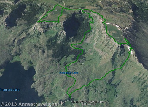
After ascending Amphitheatre Peak, we decided we didn’t really want to descend the way we’d come along the Wall Lake Trail (#1818). I’m sure some of our group would have been just as happy to do this, but others of us had been looking at topo maps of the area and were ready for another adventure before the day was out: hiking over to Himes Peak, down to the Himes Peak Trail, and then back to the parking area. Although we didn’t actually make it to Himes Peak (we’d have needed more daylight, quite a bit more stamina, and perhaps some technical climbing equipment), we did have a lovely time walking through classic Flat Tops scenery, enjoying some excitement finding our own trail, and surviving a bit of an adventure at the end as we made our way through a burned out section to get back to our vehicle. Overall, I enjoyed the hike, but I wouldn’t recommend it unless you’re quite capable of off-trail travel and don’t mind scrambling and unstable trail surfaces. This hike was about 3.5 miles (5.6 km) from the Wall Lake Trail junction back to the parking area; in other words, it wasn’t any longer than taking the Wall Lake Trail back the way we’d come.
(Affiliate links are present on this page.)
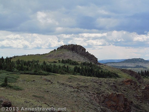
When we returned to the Wall Lake Trail (#1818)/Oyster Lake Trail (#1815) Junction, we turned left down the Oyster Lake Trail (#1815) instead of turning right back down over the edge of the Flat Tops. The trail is quite flat as it skirts the lake and then heads across the Flat Tops toward some other lakes. After 0.1 miles (0.2 km), we thought we saw a trail leading off in the general direction we wanted to go, so we left the Oyster Lake Trail on the right and began hiking cross-country again. Our goal was a large hump of rock that seemed to be a high point. As we drew closer, it was pretty easy to see that the hump of rock (which I called “The Dragon’s Back”) was simply a fin of rock crossing the arm of the Flat Tops we were hiking out onto. At first, we wondered if we could get around it at all, but we soon discovered that by going to the far right end we could get over the rocks fairly easily – it looked as if many people before us had also taken this route. One member of our group scaled the Dragon’s Back and said the view was really nice, but since the clouds had rolled in none of the rest of us attempted it.
What we should have done here (if we wanted to get to Himes Peak quickly) was to turn left on the other side of the Dragon’s Back and then skirt the western edge of the arm until we came to a trail down. However, if we’d done that then we wouldn’t have had so many nice views, so I can’t complain about the way we went.
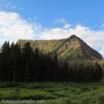
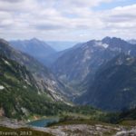
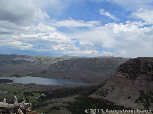
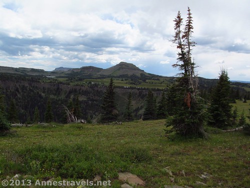
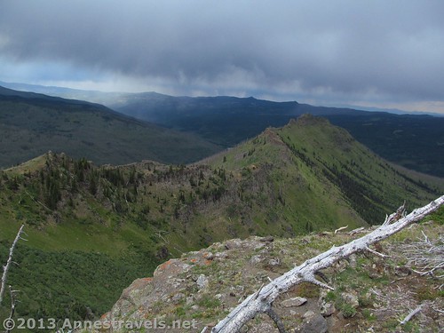
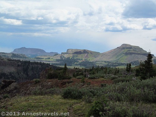
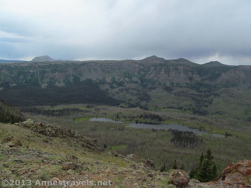
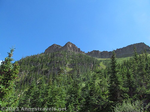
We continued to hike along the arm, staying fairly close to the right (east) side of the arm. At one point, a rock ledge offered spectacular views of Trappers Lake, its valley, and the Flat Tops on the other side of the valley. It was too bad that the weather wasn’t nicer. Not only did it make for dull pictures, but everyone in the group was antsy about thunderstoms and therefore wasn’t in the mood to stop and enjoy the view. Moving on, we skirted the edge of Flander BM (aka Flander Peak; 11,493ft. (3,503m)) without realizing it and then – quite suddenly – we came to the end of the arm. A 500 ft. (150 m) cliff is the only way down to the next step of the arm (which eventually leads to Himes Peak – from here, you can see Himes Peak as the highest point on the rocky arm below you).
At this we were a bit perplexed; there wasn’t a trail down and there didn’t seem to be any easy route to take (nor even a hard route to take!). We scouted around for a bit by walking back along the western edge of the arm and finally discovered a sort of trail/route down from the top of the Flat Tops which seemed to hug the side of the arm at the right elevation for a bit. However, by the time we’d found this, we’d hiked most of the way back to the Dragon’s Back, so if you’re wanting a faster hike (with fewer views of Trappers Lake), you could probably just walk around the Dragons Back and then along the western edge of the arm until you found the trail.
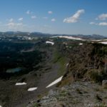
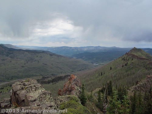
The “trail” down turns right quite quickly to run along the side of the cliff. It’s more of a route than a trail in some places, as the sandy/rocky soil isn’t very stable. Watch your footing carefully and try to stay heading generally at the same elevation as you hike along the cliff. Also, watch out for falling trees – the fire burned through this area and left plenty of sanding, yet dead, trees. As if you didn’t have enough to watch out for, the view is also very nice since you’re looking into the Big Fish Creek drainage with many named and unnamed lakes, as well as the Little Marvine Peaks on the Flat Tops beyond. Finally, we reached the end of the cliff and came out on the arm exactly where we wanted to be. The video below was taken from this ridge.
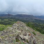
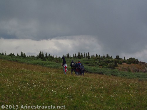
However, by this point the clouds were still stormy, people were tired and hungry, and the day was pretty far spent. Beyond that, looking down the arm, we could see that it would be no easy feat to hike over to Himes Peak as we’d originally planned – the rocky arm rolls along like the back of a sea serpent, with jagged spires and rocks. It would be doable, especially if you descended below the rock line to hike the arm and then ascend Himes Peak. However, my group was not up to this, so we finally decided to shoot for a clearing we’d seen from the higher part of the arm with what looked like a road heading in the right direction (back toward the Wall Lake parking area).
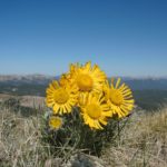
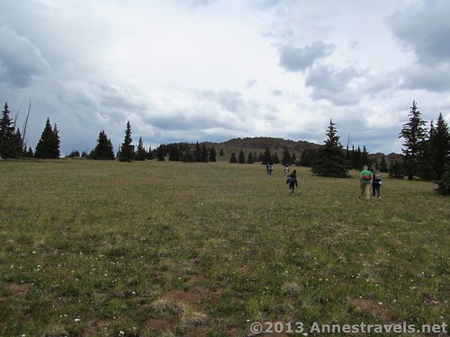
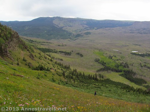
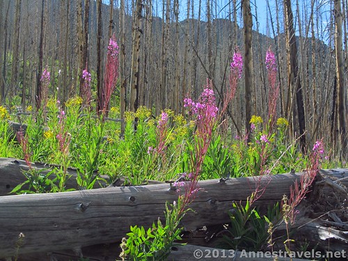
We took a bearing and then started to descend the arm – no easy feat, we quickly found out! The ground is a bit slippery and unstable (and very steep), but we all managed to get down safely to the tree line. At the tree line, a new challenge waited for us: trees. Not only could we now not see where we were going, but this is a pretty burned out section, so we were hopping over fallen trees and avoiding standing ones (be extremely careful in this section as the trees could fall at any moment). The nice part was that the sun finally came out (yay!) and the wildflowers were lovely.
The part of the group who was the furthest ahead kept us on track, and we eventually made it down to the clearing where there was the cap on a well. From here, a rutted road leads east. We followed this, which wasn’t much easier than walking through the trees, but was enough easier that we stayed on it. By now, we were down off the Flat Tops, so the road was flatter and less steep. The road eventually took us basically right to the Wall Lake Trail, nearly at the Wall Lake Trailhead. Turn left on the trail and you should come to the trailhead quite quickly.
It was an exciting adventure, perhaps more exciting than I’d normally want, but enjoyable. If you hike over to Himes Peak, I’d recommend you shoot for the Himes Peak Trail (which doesn’t go anywhere close to Himes Peak) and then take that back to the Trappers Lake area and your vehicle rather than going to the well – in fact, if you can avoid the well area altogether, you’ll probably be happier!
Round Trip Trail Length: About 6.5 miles (10.5 km) to go up the Wall Lake Trail, right on the Oyster Lake Trail, and then follow the directions here; closer to 10 miles (16 km) if you do Amphitheatre Peak as well.
Facilities: None. If you want restrooms, you’ll have to go to one of the nearby campgrounds. Note that there is basically no free-range camping allowed anywhere near Trappers Lake. We ended up spending the night in one of the campgrounds – which, by the way, have extremely varied fees (we saw everything from $12 to $22 for exactly the same services within a mile (or km) of each other!)
Elevation Gain/Loss: About 1,650ft. (500 m)
Fees: None other than camping fees in campgrounds.
Trail 
![]()
![]()
![]()
![]()
Road ![]()
![]()
Signs ![]()
![]()
![]()
Scenery
Would I go 100 miles out of my way for this?
Overall Rating: ![]()
![]()
Key GPS Coordinates for Amphitheatre Peak & Himes Peak
Parking Area: 39.990559N / 107.243316W (39°N 59′ 26.0118″ / 107°W 14′ 35.937″)
Trail Beginning: 39.99046N / 107.24319W (39°N 59′ 25.6554″ / 107° 14′ 35.4834″) (9,801 ft.; 2,987 m)
Wall Lake Trail Carhart Trail Junction: 39.98307N / 107.24419W (39°N 58′ 59.0514″ / 107°W 14′ 39.084″) (9,833ft.; 2,997 m) 0.7 miles (1.1 km)
“The Avenue”: 39.97664N / 107.25176W (39°N 58′ 35.904″ / 107°W 15′ 6.336″) (10,253 ft.; 3,125 m) 1.7 miles (2.7 km)
Wall Lake Trail / Oyster Lake Trail Junction: 39.96445N / 107.25716W (39°N 57′ 52.0194″ / 107°W 15′ 25.7754″) (11,017ft; 3,358 m) 3.2 miles (5.1 km) on the way out; 6.6 miles (10.6 km) on the way back
Leave the Oyster Lake Trail: 39.96428N / 107.25846W (39°N 57′ 51.408″ / 107°W 15′ 30.4554″) (11,040 ft.; 3,364 m) 6.7 miles (10.7 km)
Dragon’s Back Area (Approximate): 39.974586N / 107.260144W (39°N 58′ 28.5096″ / 107°W 15′ 36.5178″)
Trail Down Toward Himes Peak (Approximate): 39.982774N / 107.262094W (39°N 58′ 57.9858″ / 107°W 15′ 43.5384″)
Well: 39.98885N / 107.25188W (39°N 59′ 19.8594″ / 107°W 15′ 6.7674″) (10,081ft.; 3,072 m) 10.1 miles (16.25 km)
(All GPS coordinates are correct to the best of my knowledge; however, they should not be used as a sole resource when hiking. Always carry a map of the area, a compass, and trail information.)
The gpx file for Amphitheatre Peak-Himes Peak can be downloaded – please note that this is for reference only and should not be used as a sole resource when hiking this trail.
Download GPS File File size: 283.7 KB Downloaded 650 times
(Note: I do my best to ensure that all downloads, the webpage, etc. are virus-free and accurate; however, I cannot be held responsible for any damage that might result, including but not limited to loss of data, damages to hardware, harm to users, from use of files, information, etc. from this website. Thanks!)
Getting to Amphitheatre Peak/Himes Peak Trailhead:
From the Meeker Airport, drive about 0.5 miles (0.8 km) northeast on Hwy 789/Hwy 13 to County Road 8/State Hwy 132; turn right onto this road. This junction is 32 miles (51.5 km) south of the hamlet of Hamilton. Drive 38.6 miles (62.1 km) on County Road 8 (State Hwy 132 disappears fairly quickly). Turn right onto County Road 8a; this junction is not very well-marked so be on the lookout for it. At 7.5 miles (12 km), turn right again to cross the bridge. Pass the campgrounds; 1.5 miles (2.4 km) after the junction you will come to a sharp turn in the road and the Wall Lake parking area straight ahead. Park here. If you miss the parking area, it isn’t far down to the Trappers Lake parking area and the end of the road where you can turn around.
Alternatively, from CO-131 in Yampa, turn west onto County Road 17. This will be a left-hand turn after the town if you’re coming from the south; a right-hand turn just before the town if you’re coming from the north. Drive 5.5 miles (8.8 km) being careful to stay on County Road 17, which will turn into County Road 19 when it intersects County Road 13 (go straight onto County Road 19 at that junction). After 5.5 miles (8.8 km), turn left onto County Road 132, which is now a dirt road (going right is a paved road). Drive this road for almost 38 miles (61 km); the road will become County Route 8 along the way. After 38 miles (61 km), turn left onto County Route 8. Again, this is not exactly well-marked, so be on the lookout for the turn. Continue 7.5 miles (12 km); turn right to cross the bridge. Drive another 1.5 miles (2.4 km) to the parking area, which is past all the campgrounds and straight ahead when the road takes a sharp turn to the left. A sign indicates that this is the Wall Lake Trailhead.
The roads are well-maintained dirt/gravel. They should be quite drivable by most average-sized vehicles in good weather; in wet weather take extreme caution as there are no guardrails and the road can become quite slippery.
This Week’s Featured Product!
Want more hikes in the Flat Tops? The author of this book has hiked in the area for years and offers and insider’s view on the Flat Tops Wilderness.