
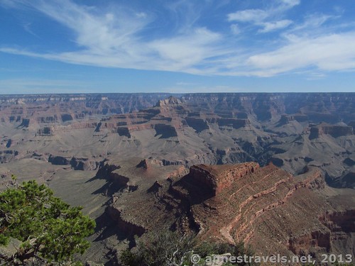
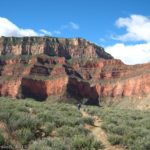
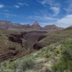
Part of the view from Shoshone Point – Newton Butte is in the foreground
An accessible, deserted viewpoint at the South Rim of the Grand Canyon with fabulous views? Yeah, right, I thought when I first heard about Shoshone Point. However, I found out that the Point is deserted compared with other viewpoints on the South Rim, and the views really are outstanding. It’s a bit of a different view than you’d get at any of the viewpoints serviced by the park shuttle buses, but it’s still breathtaking: Summer Butte, Zoroaster Temple, Brahma Temple, the Ottoman Amphitheater, Newberry Butte, Wotans Throne, the “Great Whites” on the South Kaibab Trail, and Vishnu Temple, just to name a few of the formations you can see. There is a short, easy walk (1 mile (1.6 km) each way) to get to Shoshone Point, but that’s a very small price to pay for a bit of solitude and the views!
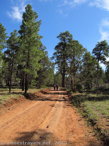
The Shoshone Point Trail
We decided to hike out to Shoshone Point the day after we’d hiked the Horseshoe Mesa Loop. Needless to say, after a 17.5 mile (28.2 km) hike the day before, we were all pretty tired and didn’t want anything too difficult. Still, we also didn’t want to stiffen up, so Shoshone Point seemed like the perfect hike. We drove past the parking area the first time, but on the way back it wasn’t too hard to locate. The trail is simply the continuation of the dirt road after the parking area. Head over toward the gate, skirt it, and then follow the sandy road.
The entire road is flat and is certainly an easy walk. The road is fairly dusty, but the dust isn’t deep, so it doesn’t impact walking like deep sand. It’s also a pleasant walk because the road winds its way through a pine forest. This isn’t to say that the road is shaded, but there is some relief from the hot sun with the occasional pine tree that is close enough to the road to cast some shade.
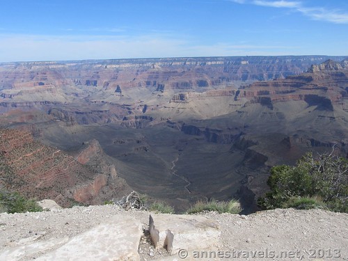
At Shoshone Point
After 1 mile (1.6 km), the road splits. It doesn’t matter which road you take, as both take you to the same place (the road split is actually a loop for vehicles to turn around). Near here is a primitive restroom. Take the road around to the far end of the loop, then turn off the road toward the area that has a pavilion, several grills, and some picnic tables. Shoshone Point can be rented for weddings and other events; however, everyone must walk in except for those who can’t walk in who can be shuttled to the point by park staff. When Shoshone Point is booked, the public is not welcome to visit – so you might want to check with the park staff before you take the trail. Pass through the picnic tables, continuing to walk straight toward the edge of the canyon. Follow the trail that now appears, scrambling up some rocks and following these toward the canyon rim.
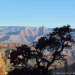
Part of the view from Shoshone Point
Suddenly, you will walk out onto a white rock and find yourself right on the edge of the Grand Canyon. You are now on Shoshone Point – go over to the edge, or simply sit back and enjoy the view! Right ahead of you is Newton Point; further out on the same arm is Pattie Butte. Over on the left, you can see the “Great Whites” of the South Kaibab Trail (some very steep swithbacks that are a very hard hike if you’re walking up them with a full pack), and to the right there is a glimpse of the Colorado River. (The best map I know of for identifying formations at the Grand Canyon can be found at http://www.nps.gov/grca/planyourvisit/upload/grca_pano.pdf.) Enjoy the view in all directions; it is fabulous! Be careful, though – there aren’t any railings to keep you from falling over the edge! The video below was taken of the view at Shoshone Point.
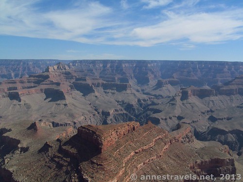
Newton Butte
We did meet several people – at least two small groups came and went while we were at the Point. This was fairly early in the morning in May, so I can’t say that Shoshone Point is deserted – just that it has far, far fewer people than you’d find at most other viewpoints.
Return by the way you came. Shoshone Point probably isn’t worth it if you don’t have much time in Grand Canyon, but if you have a few days, it’s a lovely way to spend a couple hours from a different-from-normal vantage point!
Round Trip Trail Length: 2 miles
Facilities: None at the trailhead; there is a primitive restroom near the pavilion.
Net elevation gain/loss: 131 ft.
Fees: $25 fee to enter Grand Canyon National Park, valid 7 days. America the Beautiful (Interagency), Senior (Golden Age), Access (Golden Access), Volunteer, Military, and Grand Canyon Annual Passes also accepted
Trail 
![]()
Road
Signs ![]()
![]()
![]()
![]()
Scenery
Would I go 100 miles out of my way for this? ![]()
![]()
Overall Rating: 
![]()
Key GPS Coordinates for Shoshone Point Trail:
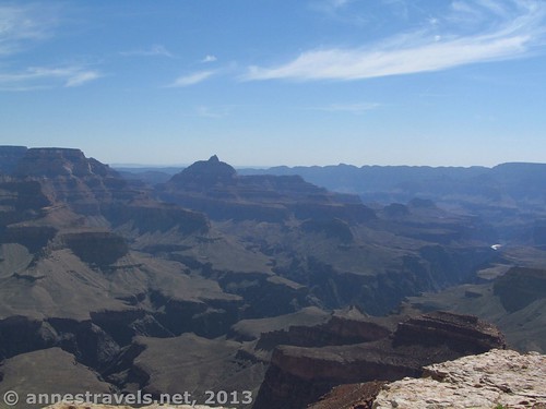
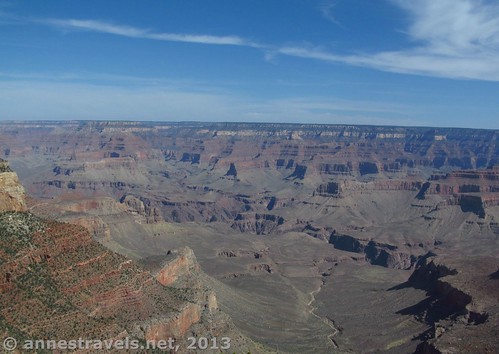
Vishnu Temple (center left) and the Colorado River (right)
Shoshone Point Parking: 36.03521N / 112.06931W (7142ft.)
Shoshone Point Trail Beginning: 36.03540N / 112.06894W (7187ft.)
Road Split: 36.04373N / 112.05922W (7263ft.)
Shoshone Point Picnic Area/Pavilion: 36.04460N / 112.05933W (7247ft.)
Shoshone Point: 36.04582N / 112.05887W (7255ft.)
The gpx file for the Shoshone Point Trail can be downloaded – please note that this is for reference only and should not be used as a sole resource when hiking this trail.
Download GPS File File size: 14.9 KB Downloaded 516 times
(Note: I do my best to ensure that all downloads, the webpage, etc. are virus-free and accurate; however, I cannot be held responsible for any damage that might result, including but not limited to loss of data, damages to hardware, harm to users, from use of files, information, etc. from this website. Thanks!)
Getting to Shoshone Point Trailhead:
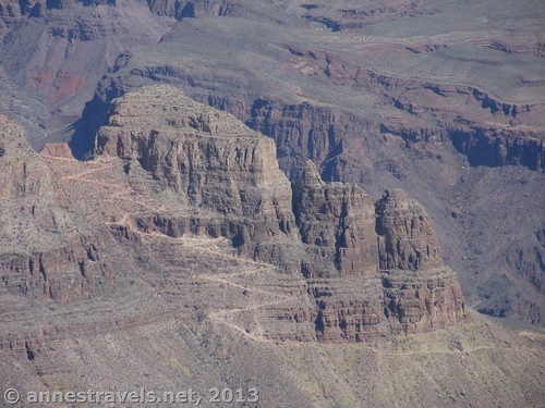
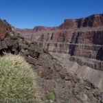
The “Great Whites” on the South Kaibab Trail. Skeleton Point is just to the left of the photo.
From the South Entrance Road on Grand Canyon National Park’s South Rim, turn onto the East Rim Drive (toward Desert View). Drive exactly 2.4 miles to a small, sandy parking area on the left side of the road between mile posts 244 and 245. This parking area is unmarked. It will probably only look like the entrance to a gated road. Park in the open area before the gate, but do not block the gate. Then walk the road out to Shoshone Point.
If you’re coming from the east, from Desert View drive exactly 19 miles west on the East Rim Drive (toward Grand Canyon Village). The unmarked parking area is between mile posts 245 and 244. Park in the sandy, easy-to-miss parking area before the gate (don’t bock the gate) and then proceed on foot down the dirt road beyond the gate to Shoshone Point.
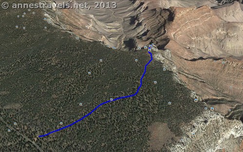
Shoshone Point Trail Map
This Week’s Featured Product!
I used this book quite a bit on our last trip to the Grand Canyon. One of the things I really liked about it is that it covers (in a fair amount of detail) many rim-toward-river hikes I didn’t know existed or wouldn’t have attempted because I didn’t know enough about the trails. The maps were also exceedingly helpful!
I really love your blog.. Vey nice colrs & theme.
Did yu dvelo this webste
yourself? leae reply bcκ
s I’m looking to create my own site and would love to learn where you got this from or what the theme is named. Cheers!
Hi Jessie,
My theme is called “Tropic Affair”. I customized it bit, including putting pictures that I took in the header, but otherwise it’s pretty much like what I downloaded.
Anne
Pingback: The 6 Best Day Hikes in Grand Canyon (South Rim)