
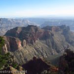
The Tonto Trail is one of the wonderful features of the Grand Canyon. You can walk for miles enjoying one view after another. And it really is mile after mile – I’ve heard that the Tonto Trail is about twice as long as the Grand Canyon simply because the trail keeps winding its way around side canyons! Because of the views, I decided to descend Horseshoe Mesa after walking to the end of it and then take the trail right around the east side of the mesa. This turned out to be both good and not so good. Many of the views were no better than what I’d seen from on top of Horseshoe Mesa, but other views showed me a side of the Grand Canyon I’d never seen before. In fact, I considered titling this post, “The Grand Canyon You Never Saw” just because the side canyon (Dark Canyon) is so different from what I’ve always known Grand Canyon scenery to look like! So, if you have a couple days, I highly recommend it, if you’re doing this as a day hike, I don’t recommend that you descend to the Tonto Trail.
(Affiliate links are present on this page.)
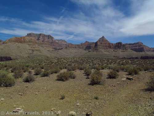
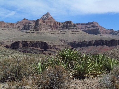
The trail from Horseshoe Mesa to the Tonto Trail begins near the western arm of the mesa. The views from the arm are spectacular (a few pictures are near the bottom of this post), so I highly recommend walking out on the arm and then returning to the trail down.
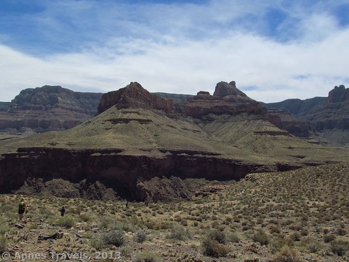
We finished our lunch at the end of the mesa, came back, and began the descent down a rocky desert valley toward the flat area that separates the outer canyon from the inner canyon. The trail itself was brutal, descending 1,000 feet (305 m) in about a mile (2 km) over a rocky path that would be better described as a route than a trail. (It distinctly reminded me of the Lava Falls Trail!) Still, it wasn’t hard to follow as it switchbacked its way through the scrub and rocks and finally ended its descent near a pile of rocks and another route that seems to go in both directions. This junction is unmarked, but we had reached the Tonto Trail: 10:40am. (As I explained in my last post, we were still living on EDT so we ate lunch at “noon”…9am Arizona time!)
I’d read that the views were better going east from this point than going west, so, after resting for a couple minutes on the rocks, we turned right and headed down the Tonto Trail (the video above was taken from this rock pile). We did not find the trail difficult to follow in most places; it’s definitely used. However, it’s also not heavily used so it does not give the nervous hiker the sense of security that many people have passed this way before.
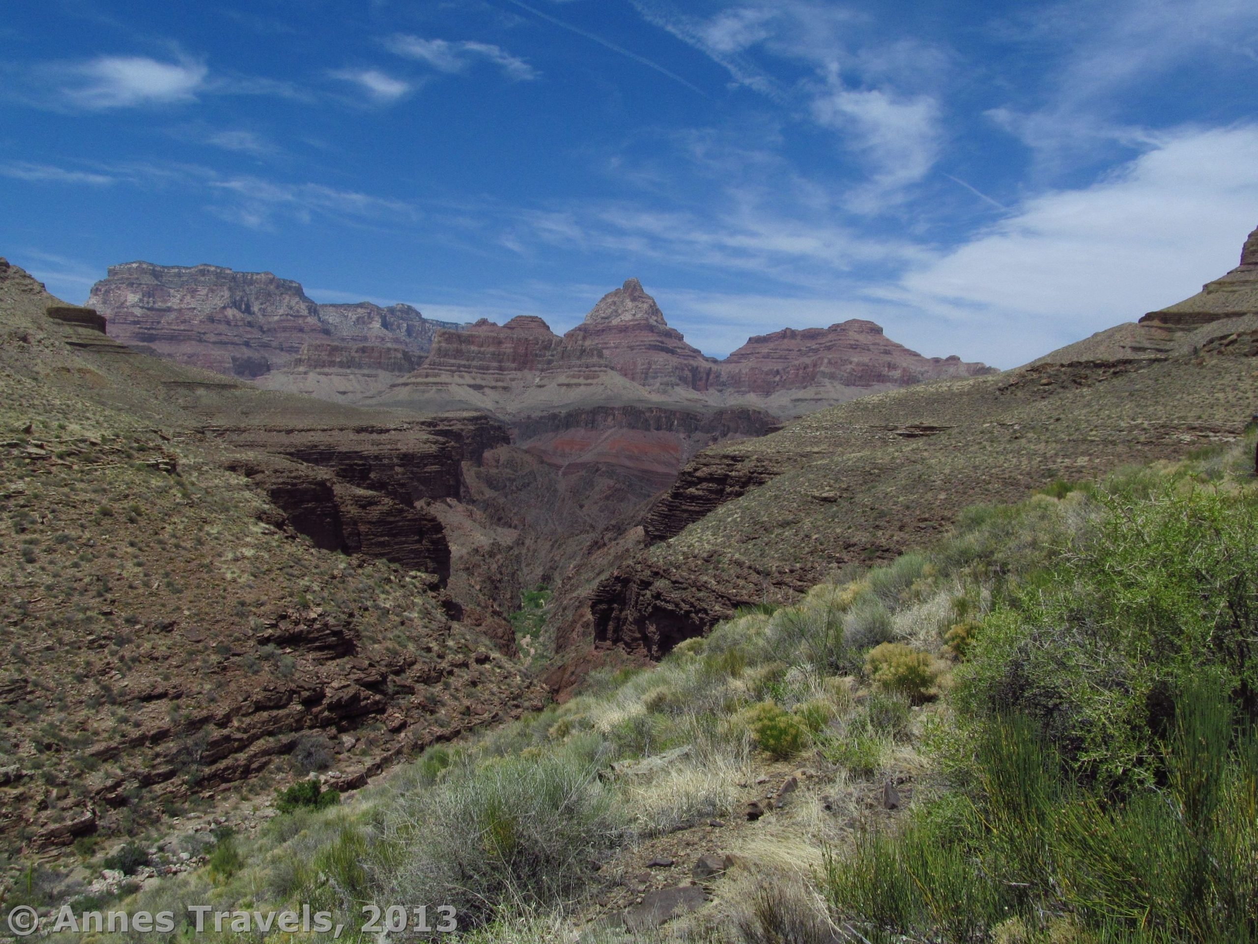
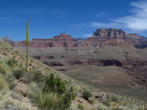
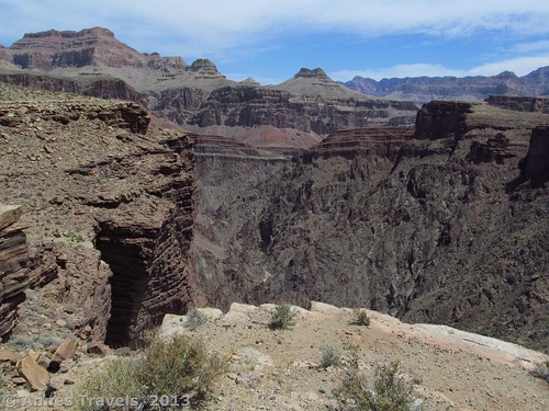
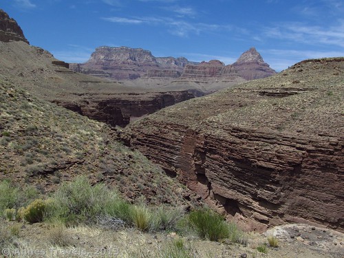
The Tonto Trail begins by plunging into a ravine (dry in mid-May, when we hiked the trail) and then climbing the other side. It then works its way around the eastern arm of Horseshoe Mesa, with views opening up ahead of and beside us. It really was beautiful, though very similar to what we’d seen from the western arm of Horseshoe Mesa. This is one of the reasons (if you’re doing a day hike) that I recommend you turn around while still on top of the mesa – you won’t have to climb back up again, and the views aren’t different enough to warrant the extra miles. However, if you’re backpacking, this would be a great place to take it slow and enjoy the scenery. For us, we stopped for a few minutes on a small rise to take in the scenery; however, by this time we were realizing the trail was longer than we’d expected and we should keep moving to get back before dark.
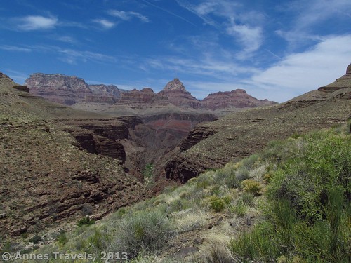
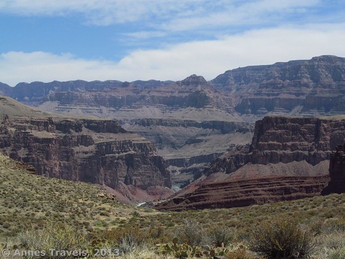
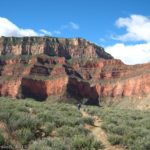
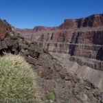
Sooner than I wished, the Tonto Trail began to descend slightly and then turned away from the main canyon, leaving most of the spectacular views behind. However, more was in store. After walking about 0.5 miles (0.8 km) along the edge of a side canyon we looked back and stopped in astonishment. Neither I nor any of my group members had ever seen black rock in the Grand Canyon before, and this side canyon (named “Dark Canyon”, I learned later) was nearly black with spires and formations sticking up from its sides. Every few yards (meters) we’d have to stop again and look back. It made this part of the trail exciting and interesting (which was a good thing since the group was starting to tire and we still had to climb back up to Horseshoe Mesa and then to the rim!)
As we neared the more southern end of the side canyon, we stopped for about 30 minutes for a snack. We were in the heat of the day now, so it was nice to find some shade under a large boulder. Then, we packed back up and continued on. The Tonto Trail continuously winds on, finally reaching the end of Dark Canyon and turning west again. Near this point, we found what we thought was the trail back up to Horseshoe Mesa – just after crossing a dry streambed, cairns led upward on a small, not-often-used trail. However, this place did not match up with my GPS coordinates, so we kept walking on the Tonto Trail. As it turned out, we could have taken this trail (and the GPS coordinates didn’t do me any good anyway), but “better safe than sorry” as the saying goes.
Eventually, we could see Hance Creek flowing many feet (meters) below us on our left. The rock was no longer black, but red like we were used to in this area of the country. Then, finally, we found the trail back up – a small side trail, but bigger than the one we’d passed earlier. I’ll talk about this part of the journey in my next post!
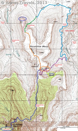
Key GPS Coordinates for Grandview Trail
Grandview Trail beginning: 35. 99846N / 111.98764W (5:07am)
Grandview/Trail to Page Spring Junction: 36.01831N / 111.97578W (7:35am)
Grandview Trail/Cottonwood Trail Junction: 36.02014N / 111.97576W (7:40am)
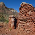
Cabin on Horseshoe Mesa: 36.02033N / 111. 97594 (7:45am)
Grandview Trail Junction with Path to Tonto Trail: 36.03136N / 111.98270W (8:40am)
End Grandview Trail and End Horseshoe Mesa (great views!): 36. 03569N / 111.98386W (8:50am)
Trail from Horseshoe Mesa/Tonto Trail Junction: 36.03667N / 111.97782W (10:40am)
Possible Trail up to Horseshoe Mesa (we went straight): 36.02264N / 111.96686W (1:05pm)
Second Trail from Tonto Trail back up around Horseshoe Mesa toward Page Spring: 36.02113N / 111. 96426W (1:30pm)
The gpx file for the Horseshoe Mesa Loop can be downloaded – please note that the section across Horseshoe Mesa (the Cottonwood Canyon Junction to the western arm) and a portion of the trail up the east side of Horseshoe mesa are not accurate due to a GPS malfunction. I apologize for any inconvenience.
Download GPS File File size: 382.1 KB Downloaded 914 times
(Note: I do my best to ensure that all downloads, the webpage, etc. are virus-free and accurate; however, I cannot be held responsible for any damage that might result, including but not limited to loss of data, damages to hardware, harm to users, from use of files, information, etc. from this website. Thanks!)
Getting to Horseshoe Mesa
From the west end of the Rim Drive (just south of the Grand Canyon Visitor Center), drive 8.7 miles (14 km) to the Grandview Point Road, on your left. Turn down this road; drive to its end and park as best as you can. This parking lot fills up quickly during the day and you are expected to park in a legal parking space. Overnight hikers are supposed to park on the far side of the loop at the end of the road, but dayhikers and sightseers also use this parking area. Hike down the Grandview Trail and across Horseshoe Mesa (directions can be accessed here and here).
Round Trip Trail Length: This section of the Tonto Trail is approximately 6 miles (9.5 km), though it didn’t feel that long. The entire loop is (according to my GPS when I returned to the parking area) 17.5 miles (28.2 km) (down the Grandview Trail, across Horseshoe Mesa, down to the Tonto Trail, across the Tonto Trail, up to Horseshoe Mesa via the trail that goes by Page (Miner’s) Spring, and back up the Grandview Trail)
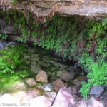
Facilities: Primitive toilets at the trailhead (no water; make sure to fill up at the visitor center or Desert View before attempting a hike); extremely primitive toilets near the Last Chance Mine on Horseshoe Mesa
Fees: $25 fee to enter Grand Canyon National Park, valid 7 days. America the Beautiful (Interagency), Senior (Golden Age), Access (Golden Access), Volunteer, Military, and Grand Canyon Annual Passes also accepted.
Trail 
![]()
![]()
![]()
Road
Signs ![]()
![]()
![]()
Scenery
Would I go 100 miles out of my way for this?
Overall Rating: ![]()
This Week’s Featured Product!
“Hiking Grand Canyon National Park” Falcon Guide is one of the best hiking guides I’ve found for Grand Canyon National Park. This isn’t because it details every trail available, but because it goes into great detail on several known and unknown trails on the south and north rims. Its maps are also fairly good – in it, I found one of the best maps of the Horseshoe Mesa Loop I’d seen to that date (it finally made all the internet descriptions make sense). The guide details many different hikes for both dayhikers and backpackers (though the book is aimed at the latter). I don’t trust the authors to a T (do your homework on the internet as well; for example, the length of the loop around Horseshoe Mesa is longer than the author’s estimate) but it’s a great resource that I’ll be using over and over again.
5 responses to “Horseshoe Mesa Loop, pt. 3: The Tonto Trail”
[…] also use this parking area. Hike down the Grandview Trail and across Horseshoe Mesa, then down the Tonto Trail, turning right at the bottom of Horseshoe Mesa (click the links for […]
[…] realized there was nothing there), and sometimes the directions are just wrong (like the 11 mile Horseshoe Mesa Loop that turned into 17.75 miles, or the 13 mile Cirque of Towers Overlook that was really more like 17 […]
[…] I’ve done two sections; one between the South Kaibab Trail and Bright Angel Trail and the other around Horseshoe Mesa. Both were beautiful! Mileage will […]
[…] was voluntarily going back down that way, even if another way was longer!), and kept walking around Horseshoe Mesa even though we were already at the 13 mile mark and nowhere near the trailhead… and the trail was […]
[…] explain our dayhike down the Grandview Trail, across Horseshoe Mesa, down to the Tonto Trail, east around Horseshoe Mesa on the Tonto Trail, then back up to the Grandview Trail via a trail past Miner’s (Page) Spring. At 17.5 miles […]