

High above US-89 north of Page, Arizona (but before Big Water), a hole in the cliff can be seen up on a butte on the west side of the road. This is Skylight Arch. While it’s difficult to view from below for more than a fleeting glance while driving (I tried; more on that later), you can hike up to it via a network of dirt roads for fantastic views of the surrounding area. You can also drive most of the way there, so today, I’m going to tell you how to drive to Skylight Arch without 4×4 (much of it could even be done with lower clearance, especially if you have AWD, such as a Subaru – I wouldn’t recommend it for a sedan like a Ford Fusion, though).
Quick Stats
I had tried to reach Skylight Arch once before. With vague instructions off the internet, we set out to do the impossible. If I’d had a GPS and the official Glen Canyon National Recreation Area Trail Description back then, we probably could have made it. But we didn’t, so we ended up with great views and discovered a lot of fallen arches instead. This time, armed with much better information, we set off again to do the impossible (which was possible with a little help from our friends).
There are two official routes to the Skylight Arch Trailhead from US-89. I’ll describe them both, plus where I deviated from the official route so I didn’t need 4×4 (my van is high clearance but only 2WD).
100% Hiking Route to the Skylight Arch Trailhead
The driving route to the beginning of the hiking route begins 8.0 miles north of the Glen Canyon Dam (5.2 miles south of Big Water; 37.0090292°, -111.5811143°). Turning west onto the road here, you can drive about 1.3 miles to the corrals (36.9959851°, -111.5956277°); almost any vehicle should be able to this in dry weather. Parking here, you can hike up some dirt roads; however, the roads are so awful that you’d have to be driving a really good jeep and be really crazy to try it.

Continue to follow the road on foot straight as it waggles down into the wash and then rises up the other side. It then heads south to a junction (36.9846842°, -111.5942506°) after 0.9 miles; turn right here to ascend an insane dirt road to another junction at mile 1.3 (36.9824359°, -111.5995365°). Turn right here on the sandy road that will soon take you to a gate (nearby is some cowboy graffiti that says, “A Button”). Views should be improving as you climb.

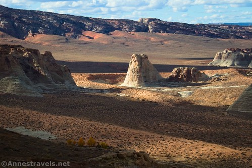
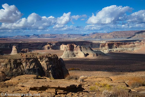
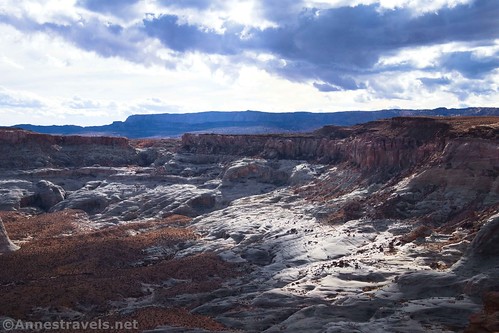
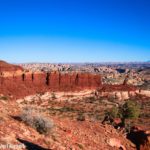
Pass through the gate (be sure to close it again after you) and climb the very steep, sandy road up the hill. Pass by Stud Horse Point on the right at mile 1.8 (36.9890914°, -111.6021753°; of course, you’re welcome to check this out if you want). The next junction is at mile 2.4 (36.9922056°, -111.6101430°); turn right to view some very cool hoodoos.
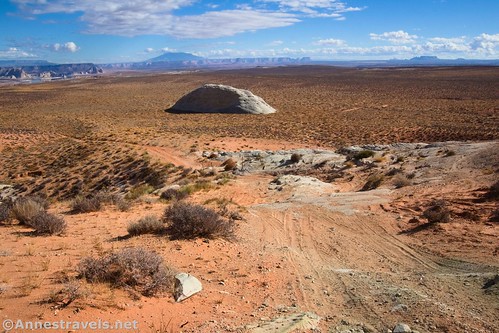
The road after this is a little bit crazy, since several routes exist for ascending some slickrock. Just try to stay on the main route and you should be fine. Pass into Utah about mile 3.3 and keep hiking to the Skylight Arch Trailhead about mile 3.7 (37.0071520°, -111.6081340°).
100% Driving Route to the Skylight Arch Trailhead
The driving route requires reasonable clearance, but it can be accessed by 2WD via this route in dry weather. Begin by turning off of US-89 5.7 miles north of the Glen Canyon Dam (7.6 miles south of Big Water; 36.9840970°, -111.5519710°) onto a paved road. Pass by a road on the left after 0.3 miles (36.9850680°, -111.5574330°) and another at mile 0.5 (36.9864240°, -111.5607370°). At mile 0.8 (36.9880750°, -111.5649000°), turn left off of the paved road. Another road will go off on the left at mile 1.3 (36.9849640°, -111.5731240°); keep going straight to a Y with signboards at mile 2.3 (36.9771140°, -111.5880410°). Take the left fork; only 0.3 miles later, roads will strike off on the right and left near a cattleguard (36.9728710°, -111.5913210°). Continue straight.

At mile 2.9, roads will again go off on the right and left. Following the official directions from Glen Canyon National Recreation Area, we dutifully turned right here up to where we met the hiking route at the top of the crazy steep hill (just before the gate). However, my van is only 2WD and couldn’t make it up the hill beyond the gate (it’s just too sandy). We gave it up, picked up our packs, and headed off to do the rest of the roads on foot. After about a quarter mile, we met a jeep with a really nice couple, out picking up trash and paroling the area (they’re volunteers). They drew me a map and told us how to take the van where we wanted to go. Their directions were excellent, so I’ll describe their route. The first thing you’ll need to do is to go straight at the mile 2.9 junction (36.9722730°, -111.5957430°) instead of turning right.
About a tenth of a mile after not turning right, the road dumps you out onto another dirt road that follows powerlines (36.9725320°, -111.5975580°); keep driving straight (which at this point means driving northwest). Pass two sideroads a tenth of a mile later (36.9729590°, -111.5985250°) and two more at mile 4.0 (36.9797220°, -111.6123600°). At mile 4.1 (36.9810250°, -111.6148830°), turn right on a side road, away from the power lines.

The next excitement is a mile 5.0 (36.9921450°, -111.6101720°). A road enters from the right (ignore it; this is where the hiking route and the driving route meet); nearby is a small area for parking with views down onto the hoodoos. Very cool!

The road strikes north from here to enter a tricky section at mile 5.2 (36.9946770°, -111.6113050°) – this is the most technical part of the road. Up to this point, most vehicles probably would be ok (though having some ground clearance is useful). The road ascends a slickrock section; there are multiple routes up the slickrock (we mostly stayed left), so take whichever one looks best to you. Once atop this section (the right-most of the routes comes back in about mile 5.6 (36.9979690°, -111.6111350°)), it’s an easy drive to the Skylight Arch Trailhead at mile 6.4 (37.0071520°, -111.6081340°).

The Skylight Arch Trail
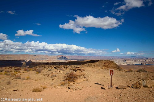
You’ve worked so hard to get to the Skylight Arch Trailhead; now it’s time to hike the actual trail! It seems that the road used to go further, but it’s been closed for a number of years beyond the trailhead.
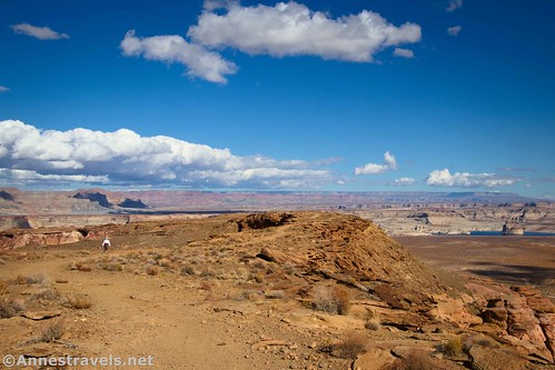
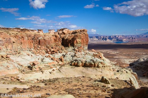
The old road travels northeast across a narrow neck of rock (views are awesome on both sides!) and then north down to the arch. Along the way, I stayed fairly right (south) to take in multiple small viewpoints.
The route becomes rockier and rougher near the end, but persevere! You’re almost there.
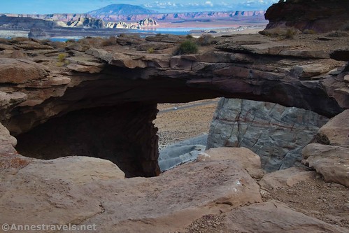
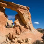
To be fair, I almost missed Skylight Arch entirely. It seemed like the path went in the direction of some rocks (there will be a rock wall behind you at this point – you’ll be turning right (away from the wall) to get to the arch). So I followed it. And then suddenly, there was a huge hole in the ground!
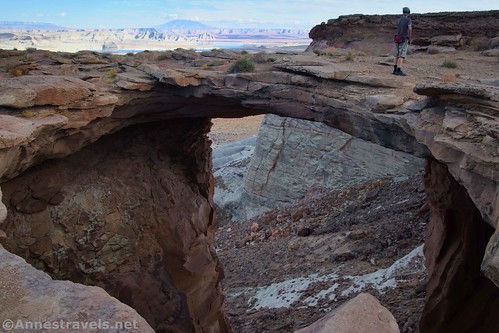
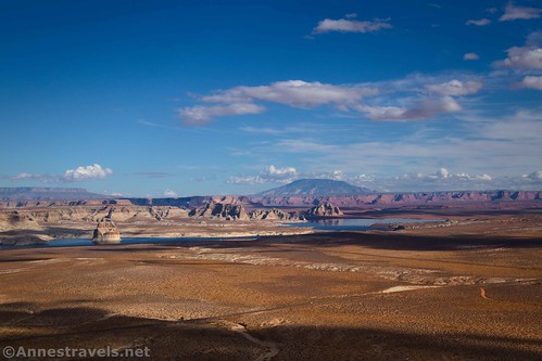
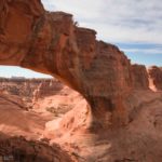
Skylight Arch is massive! Probably not quite 50ft. across, but pretty close! (Google says 43ft. as an estimate.) I tried to get pictures with people in them just so that I could give an idea of size. You’re welcome to walk all of the way around the arch, just be careful since there are no railings keeping you from stepping too close to the edge.

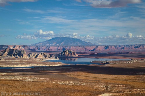
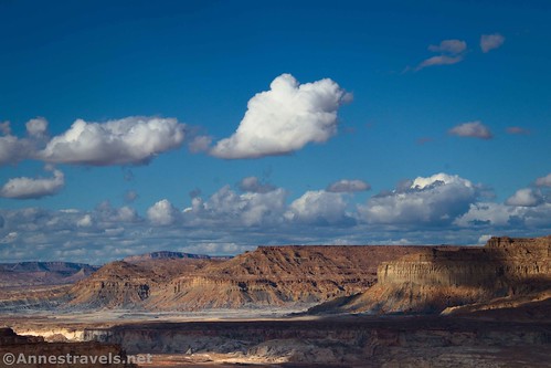
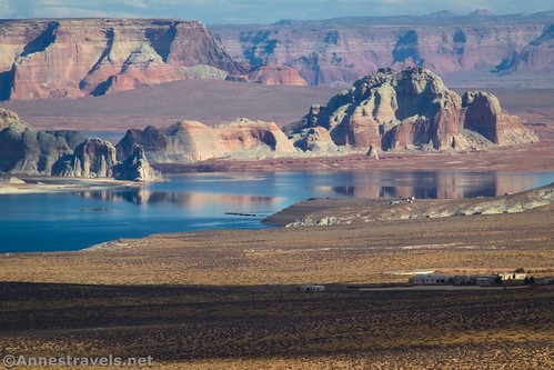
Unfortunately for me, the moment we arrived at Skylight Arch, the sun went under. But we enjoyed the spectacular views, anyway, and watched the autumn clouds sail across the plains, buttes, and Lake Powell.
When you’ve finished looking, retrace your steps to your vehicle. I can easily say it was worth the wait and the trouble to get up here – though being ready for a good adventure would be a good idea!

Skylight Arch from US-89
After we returned to US-89, we decided to check it out from the highway. Views are best from approximately 37.0165611°, -111.5894558° (because you can see light through the hole in the mesa top). However, there’s no place to safely park here. I parked in a gravel lot about 0.3 miles north up US-89 and then walked back (not a lot of fun with semi-trucks racing by at 65mph!) I also pretty much stayed on the road instead of scrambling up to the base of the cliff – I hear (though I could be wrong) that the land is private property.

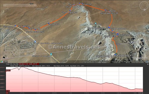
Round Trip Trail Length: Just the Skylight Arch Trail is 2.2 miles. Hiking up from the corrals would be about 9.6 miles.
Elevation Gain: About 200ft. (4,604ft. to c.4,430ft.) It was too close to the edge of the cliff for my GPS to handle the elevation accurately.
Facilities: None (though there are a few dispersed sites along the route)
Fees: None
Trail Notes: Use care near the arch, as there are no railings and it’s a long way down. There’s a real tangle of roads en route, so I highly recommend a GPS for finding the important junctions. However, realize that GPSes may or may not have signal (Skylight Arch is pretty remote) and may 1) show roads that don’t exist, and 2) not show roads that do exist. Be ready to self-rescue out here!

Trail 
![]()
![]()
![]()
Road ![]()
![]()
![]()
Signs ![]()
![]()
![]()
![]()
Scenery
Would I go 100 miles out of my way for this? ![]()
Overall Rating: ![]()
![]()
Skylight Arch Trail GPS Coordinates
Hoodoos: 36.9925940°, -111.6101680° (36°59.55564′, -111°36.61008′ / 36°59’33.3384″, -111°36’36.6048″) (4,606ft.)
TH: 37.0071520°, -111.6081340° (37°00.42912′, -111°36.48804′ / 37°00’25.7472″, -111°36’29.2824″) (4,615ft.) (0.0)
Viewpoint: 37.0110890°, -111.6011410° (37°00.66534′, -111°36.06846′ / 37°00’39.9204″, -111°36’04.1076″) (4,552ft.) (2.72)
Arch: 37.0169610°, -111.5983840° (37°01.01766′, -111°35.90304′ / 37°01’01.0596″, -111°35’54.1824″) (4,428ft.) (3.34)
End: 37.0071450°, -111.6081420° (37°00.42870′, -111°36.48852′ / 37°00’25.7220″, -111°36’29.3112″) (4,615ft.) (4.31)

GPS Coordinates for the Drive from Skylight Arch TH back to US-89
TH: 37.0071520°, -111.6081340° (37°00.42912′, -111°36.48804′ / 37°00’25.7472″, -111°36’29.2824″) (4,615ft.) (0.0)
Junction: 36.9979690°, -111.6111350° (36°59.87814′, -111°36.66810′ / 36°59’52.6884″, -111°36’40.0860″) (4,730ft.) (0.76)
Junction: 36.9974170°, -111.6132850° (36°59.84502′, -111°36.79710′ / 36°59’50.7012″, -111°36’47.8260″) (4,714ft.) (0.89)
Junction: 36.9967040°, -111.6138260° (36°59.80224′, -111°36.82956′ / 36°59’48.1344″, -111°36’49.7736″) (4,700ft.) (0.95)
Junction: 36.9946770°, -111.6113050° (36°59.68062′, -111°36.67830′ / 36°59’40.8372″, -111°36’40.6980″) (4,648ft.) (1.22)
Junction by the hoodoos: 36.9921450°, -111.6101720° (36°59.52870′, -111°36.61032′ / 36°59’31.7220″, -111°36’36.6192″) (4,606ft.) (1.42)
Junction with powerlines: 36.9810250°, -111.6148830° (36°58.86150′, -111°36.89298′ / 36°58’51.6900″, -111°36’53.5788″) (4,498ft.) (2.28)
Junction: 36.9797220°, -111.6123600° (36°58.78332′, -111°36.74160′ / 36°58’46.9992″, -111°36’44.4960″) (4,491ft.) (2.44)
Junction: 36.9729590°, -111.5985250° (36°58.37754′, -111°35.91150′ / 36°58’22.6524″, -111°35’54.6900″) (4,447ft.) (3.33)
Junction: 36.9725320°, -111.5975580° (36°58.35192′, -111°35.85348′ / 36°58’21.1152″, -111°35’51.2088″) (4,443ft.) (3.41)
Junction: 36.9722730°, -111.5957430° (36°58.33638′, -111°35.74458′ / 36°58’20.1828″, -111°35’44.6748″) (4,437ft.) (3.51)
Cattleguard/Junction: 36.9728710°, -111.5913210° (36°58.37226′, -111°35.47926′ / 36°58’22.3356″, -111°35’28.7556″) (4,376ft.) (3.76)
Junction with signs: 36.9771140°, -111.5880410° (36°58.62684′, -111°35.28246′ / 36°58’37.6104″, -111°35’16.9476″) (4,327ft.) (4.13)
Junction: 36.9849640°, -111.5731240° (36°59.09784′, -111°34.38744′ / 36°59’05.8704″, -111°34’23.2464″) (4,265ft.) (5.11)
Junction with paved road: 36.9880750°, -111.5649000° (36°59.28450′, -111°33.89400′ / 36°59’17.0700″, -111°33’53.6400″) (4,175ft.) (5.62)
Junction: 36.9864240°, -111.5607370° (36°59.18544′, -111°33.64422′ / 36°59’11.1264″, -111°33’38.6532″) (4,125ft.) (5.88)
Junction: 36.9850680°, -111.5574330° (36°59.10408′, -111°33.44598′ / 36°59’06.2448″, -111°33’26.7588″) (4,148ft.) (6.07)
Junction with US-89: 36.9840970°, -111.5519710° (36°59.04582′, -111°33.11826′ / 36°59’02.7492″, -111°33’07.0956″) (4,141ft.) (6.41)
GPS Coordinates for the Hiking Route to Skylight Arch TH via the Corrals
Turnoff to the corrals (only if you’re hiking): 37.0090292°, -111.5811143° (37°00.54175′, -111°34.86686′ / 37°00’32.5050″, -111°34’52.0116″)
Corrals: 36.9959851°, -111.5956277° (36°59.75911′, -111°35.73766′ / 36°59’45.5465″, -111°35’44.2596″) (0.0)
Junction (go right up hill): 36.9846842°, -111.5942506° (36°59.08105′, -111°35.65504′ / 36°59’04.8630″, -111°35’39.3023″) (0.9)
Junction (go right to gate): 36.9824359°, -111.5995365° (36°58.94615′, -111°35.97219′ / 36°58’56.7693″, -111°35’58.3315″) (1.3)
Turnoff for Stud Horse Point: 36.9890914°, -111.6021753° (36°59.34549′, -111°36.13052′ / 36°59’20.7292″, -111°36’07.8311″) (1.8)
Junction near hoodoos (turn right): 36.9922056°, -111.6101430° (36°59.53234′, -111°36.60858′ / 36°59’31.9403″, -111°36’36.5150″) (2.4)
Skylight Arch TH: 37.0071520°, -111.6081340° (37°00.42912′, -111°36.48804′ / 37°00’25.7472″, -111°36’29.2824″) (4,615ft.) (3.7)

The gpx file for the Skylight Arch Trail can be downloaded – please note that this and the GPS Coordinates are for reference only and should not be used as a sole resource when hiking this trail.
Download GPX File size: 38.7 KB Downloaded 323 times
The gpx file for the road to the Skylight Arch TH can also be downloaded – please note that this and the GPS Coordinates are for reference only and should not be used as a sole resource when hiking this trail. Also note that the GPX file runs from the trailhead back to the main highway (US-89).
Download GPX File size: 19.8 KB Downloaded 312 times
(Note: I do my best to ensure that all downloads, the webpage, etc. are virus-free and accurate; however, I cannot be held responsible for any damage that might result, including but not limited to loss of data, damages to hardware, harm to users, from use of files, information, etc. from this website. Thanks!)
Today’s Featured Product!
Explore 100 trails in Utah, many of them just north of Skylight Arch! The book is highly rated and includes everything you need to plan hikes through the state. Buy your copy here.


Pingback: Sneak Peak: Petrified Forest, Southern Utah, and Death Valley! – Anne's Travels