
Winter Camp Arch is located just outside of Arches National Park, but to get to it, you’ll have to drive the dirt roads into the Yellowcat Flat area northeast of Moab, Utah. A low-clearance vehicle might be able to make it in from I-70 in dry weather, but you’re much better off with high clearance (4×4 wasn’t necessary for us). To make the hike even more of an adventure, there’s no trail, no signs, and no dedicated parking area. You’re pretty much alone and on an adventure out here!
Quick Stats
Note: Some of the links in this post are affiliate links. If you click one and purchase something, I may earn a small commission without an extra cost to you.

But if you can make it, it’s really an interesting and fun arch to see. It’s also near Covert Arch, so you can make a day of it and visit both spans (depending on the level of your adventure meter…) The terrain makes Winter Camp Arch easier than it might be to find, so strap on your hiking boots, take a good map and compass, and we can get started!
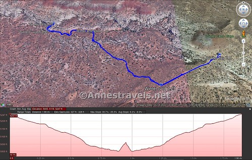
I began hiking at the top of the hill on the road (see the driving directions at the bottom of this post – the road is called the Winter Camp Ridge Road, but it’s not marked with this name). I hiked for a quarter mile down the road (more or less to the bottom of the hill and a short distance more) before striking right (north) off of the road.
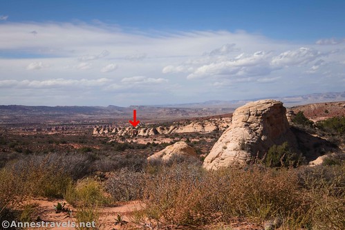
Actually, if you know where to look and the sun is shining, you can see the shadow of Winter Camp Arch in the fins to the north-northeast. But it vanishes fairly quickly after you leave the road.
After leaving the road, I headed north and a little west across the desert. I tried to leave no trace and generally followed washes and/or slickrock sections (not too many of those!) and cow trails when all else failed.

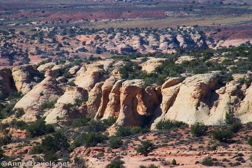
About half a mile from the road, we dropped down into Winter Camp Wash (a major east-west drainage – it’s a bit of a low-walled canyon at this point). If you’re having trouble finding a way down, walk left (west) along the rim until you find a safe place to scramble. You might also be able to follow a side wash down into the main wash.

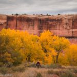
Winter Camp Wash is an intriguing canyon if not especially exciting. The walls are often 6-12ft. deep, slightly overgrown, though the bottom of the wash is easy enough to walk on and most definitely not a slot. A few small dryfalls are more interesting than really challenging.

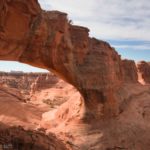
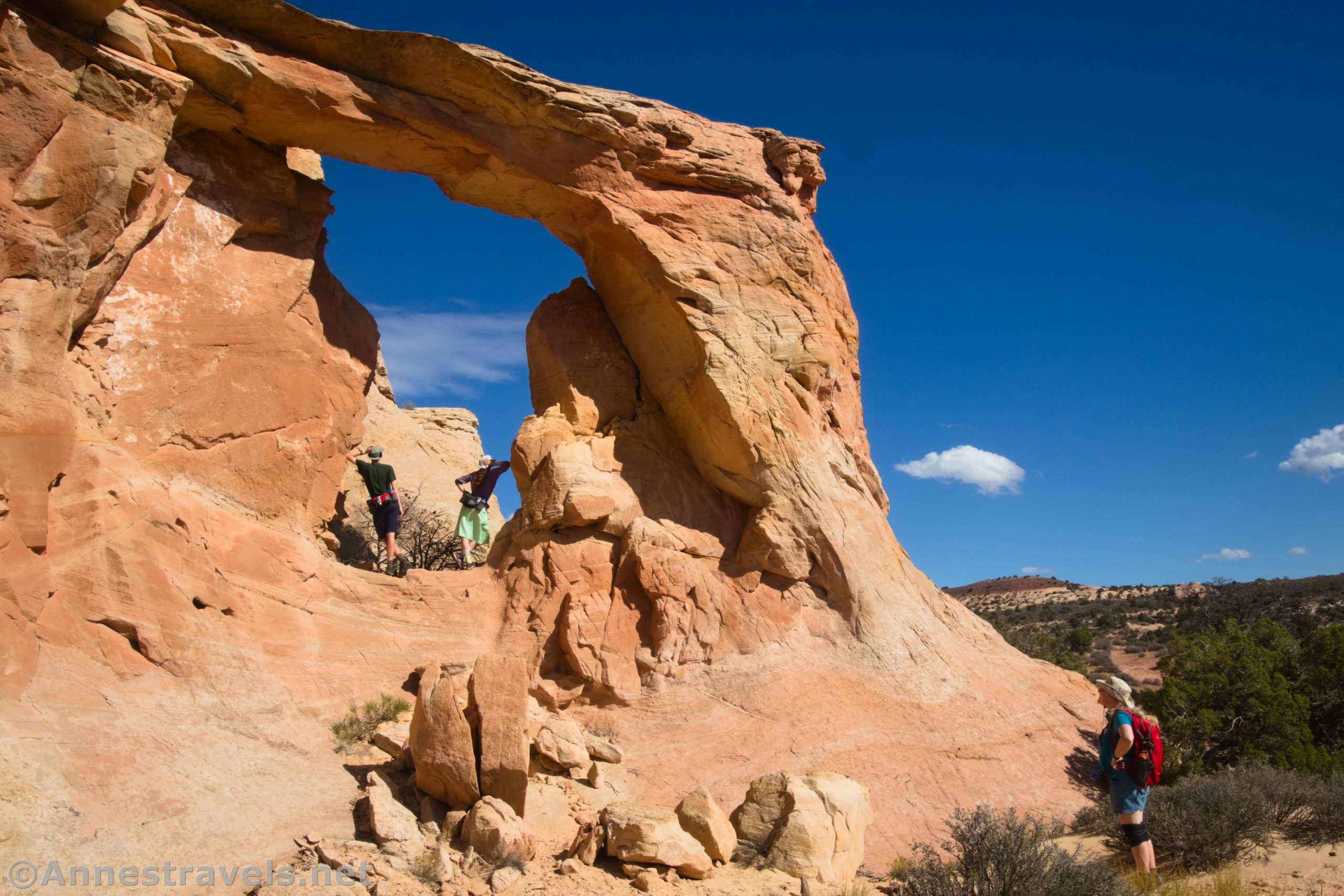
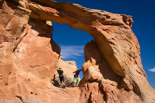
Exactly where you enter Winter Camp Wash will determine how long you’ll follow it. I walked downstream for just over 0.2 miles before I came to the arch on the right (north) side of the wash. (Actually, we hiked a few yards past it and then realized our mistake.)

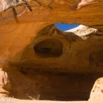
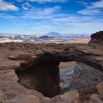
We scrambled up the west-facing side of the arch (it was in sunshine since we hiked it in the afternoon). The arch has a unique shape and is bigger than it looks in the pictures!

A few of my group scrambled through the arch and then up above it. I went into the arch but stayed down with another member of the group who’s not much on scrambling. While they enjoyed the challenge, I enjoyed views to the La Sal Mountains to the southeast.

Then we retraced our steps back up the wash, back across the desert, and back up the road to our van. It ended up being just about a 2 mile hike – not bad when we didn’t have a trail to follow!

Round Trip Trail Length: I went 2.0 miles
Elevation Gain: 328ft. (5,247ft. to 5,000ft.)
Facilities: None. There is a primitive (very primitive!) campsite at the start point.
Fees: None

Trail Notes: Remember, there is no trail. It is your responsibility to make sure you leave no trace and that you don’t get lost (or at least, that’s one way to put it!) Try not to step on the black, pokey-looking dirt (cryptobiotic soil), as this helps to hold the desert together and avoid erosion. If you get lost, head south and you’ll hit the road sooner or later. The arch is not in Arches National Park, but it is still protected – remember, leave no trace, and respect others who will come after you!

Trail 
![]()
![]()
![]()
Road ![]()
![]()
![]()
Signs ![]()
![]()
![]()
![]()
Scenery ![]()
Would I go 100 miles out of my way for this? ![]()
Overall Rating: 
![]()
![]()

GPS Coordinates for Winter Camp Arch
TH: 38.7868060°, -109.4630320° (38°47.20836′, -109°27.78192′ / 38°47’12.5016″, -109°27’46.9152″) (5,276ft.) (0.0)
Leave Road: 38.7851550°, -109.4669790° (38°47.10930′, -109°28.01874′ / 38°47’06.5580″, -109°28’01.1244″) (5,209ft.) (0.25)
Enter wash: 38.7890600°, -109.4714880° (38°47.34360′, -109°28.28928′ / 38°47’20.6160″, -109°28’17.3568″) (5,078ft.) (0.72)
Leave wash: 38.7892360°, -109.4748900° (38°47.35416′, -109°28.49340′ / 38°47’21.2496″, -109°28’29.6040″) (5,030ft.) (0.96)
Winter Camp Arch: 38.7896880°, -109.4745940° (38°47.38128′, -109°28.47564′ / 38°47’22.8768″, -109°28’28.5384″) (5,086ft.) (1.03)
Regain road: 38.7851650°, -109.4669720° (38°47.10990′, -109°28.01832′ / 38°47’06.5940″, -109°28’01.0992″) (5,209ft.) (1.76)
End: 38.7868250°, -109.4631020° (38°47.20950′, -109°27.78612′ / 38°47’12.5700″, -109°27’47.1672″) (5,276ft.) (2.01)

The gpx file for Winter Camp Arch can be downloaded – please note that this and the GPS Coordinates are for reference only and should not be used as a sole resource when hiking this trail.
Download GPX File size: 45.8 KB Downloaded 538 times
(Note: I do my best to ensure that all downloads, the webpage, etc. are virus-free and accurate; however, I cannot be held responsible for any damage that might result, including but not limited to loss of data, damages to hardware, harm to users, from use of files, information, etc. from this website. Thanks!)

Getting to Winter Camp Arch
The recommended route to Winter Camp Arch begins at I-70 Exit 193. (I hear there are two other ways of getting in – one from US-191 (I tried that and it was flooded and too sketchy for my van) and another from Owl Draw Road off of UT-128, but neither of these are recommended for 2WD vehicles). Take the exit (it should be signed for Yellowcat) and turn south. All of my mileages will be from the westbound entrance/exit ramps.
After 6.2 miles, a road will go off on the right (west) at approx. 38.8679514, -109.5499733. Continue straight (south) to mile 7.8, where you want to go left at a Y in the road (approx. 38.8489544, -109.5358285). A half a mile beyond this Y, you will see a couple of old ore hoppers on the left (north) about 38.8479059, -109.5283851. This is the Yellowcat Mine.
Keep driving to mile 9.3. Take the road that goes right (south) about 38.8504449, -109.5107063. At mile 12.0 (approx. 38.8242522, -109.4966222), a road on the right leads west to the trailhead for Lost Spring Canyon and Clover Canyon. You want to continue straight (south). Ignore the sideroads, just like you’ve been doing at several points along the route. The next turn is at mile 16.3 (approx. 38.7975664, -109.4352337); turn right (west). This is Winter Camp Ridge Road. About a tenth of a mile down the road, a second way in from the “main” road enters from the left. Continue west.

After 1.75 miles, you’ll come to an area that is often used by campers (“Winter Camp” approx. 38.786794, -109.463053). Park here. (Beyond this, the road crosses rocks and slickrock and then descends a steep hill. It’s totally doable by a high clearance van like mine, but we were a bit worried about making it back up the hill and through this section on the way back (we spun just slightly but were fine), so just park here and walk the 0.25 miles to where I left the road.) If you kept driving on the road, you’d get to the trailhead for Covert Arch.
This Week’s Featured Product!
This five-star reviewed book will guide you to and through some of the best dirt roads near Moab, Utah! With maps, color photographs, and turn-by-turn directions, it’s a great addition to planning trips to the region. Buy your copy here!