

I first saw the GPS track for Clover Canyon over on gjhikes.com. But GJ doesn’t yet have a writeup about it. I figured it out eventually that he probably doesn’t have a post on Clover Canyon because it’s not really worth doing. If you’re in the area, you’re better off hiking Lost Spring Canyon. But since I did hike it, and the photos turned out much more amazing than the hike itself, I’ll share those photos with you so you don’t have to waste your time hiking Clover Canyon yourself.
Quick Stats
Note: Some of the links in this post are affiliate links. If you click one and purchase something, I may earn a small commission without an extra cost to you.

The first adventure is getting to the trailhead. While Clover Canyon is in Arches National Park, you’ll come in through Yellowcat Flats (while you’re here, you might want to check out Covert Arch (the best of the destinations listed here), Winter Camp Arch, and/or La Boca Arch.) The dirt roads are high-clearance, 2WD-friendly in dry weather – until you get to the Lost Spring Canyon Trailhead. From there, 4×4 is useful. I did make it to the end of the road, mostly because I didn’t realize the sandy parts were coming until it was too late to stop. Thankfully, we made it all right all of the way to a small dirt parking area beside a fenced-in transformer station and evidence of the pipeline you’ll be following.

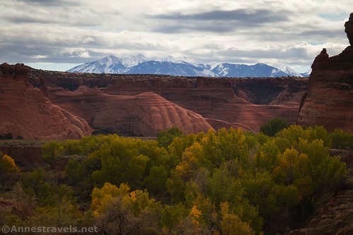
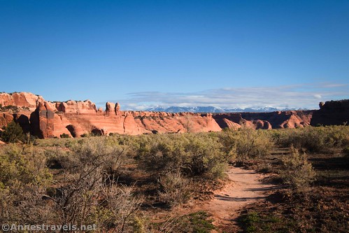
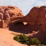
The views from the end of the road are nice. You can see into Arches National Park (including several of the famous arches) and also to the La Sal Mountains and even Castleton Tower.

Walk down the road beyond the parking area. While there’s nothing keeping you from driving to the border of Arches National Park, the road gets much rougher – it looks to me like ATVs are the only vehicles that drive this part of the road.

The road is mostly a steep downhill with views into Salt Wash and Cordova Canyon (another sidecanyon upstream from Clover Canyon). Across Salt Wash, you can see the top of the Balanced Rock, Landscape Arch, and the top of the Dark Angel, among other features.
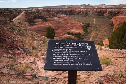
After 0.3 miles, you’ll come to a big green gate. A sign informs you that you’re entering Arches National Park and gives a brief synopsis of the park rules.
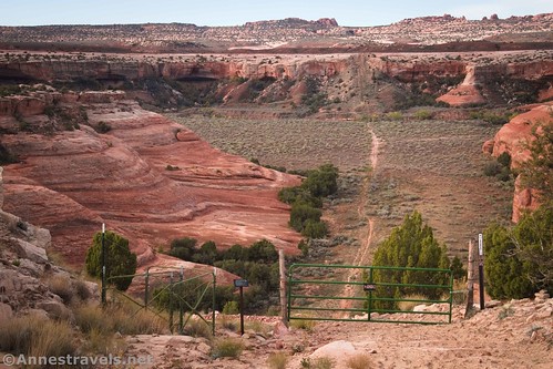
A style allows hikers to bypass the gate/fence easily and continue down the steepest part of the road up to this point. It’s seriously steep – coming back up is a good test of your lungs!

The trail finally drops into the canyon around Salt Wash about mile 0.6. Continue another tenth of a mile to where a major social trail crosses the pipeline road, just before you pass a sign that says, “170.” The social trail is also marked by a flexible brown post that reminds drivers that this is a wilderness area and vehicles are not allowed.
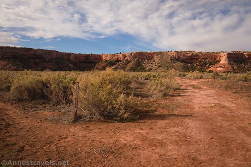
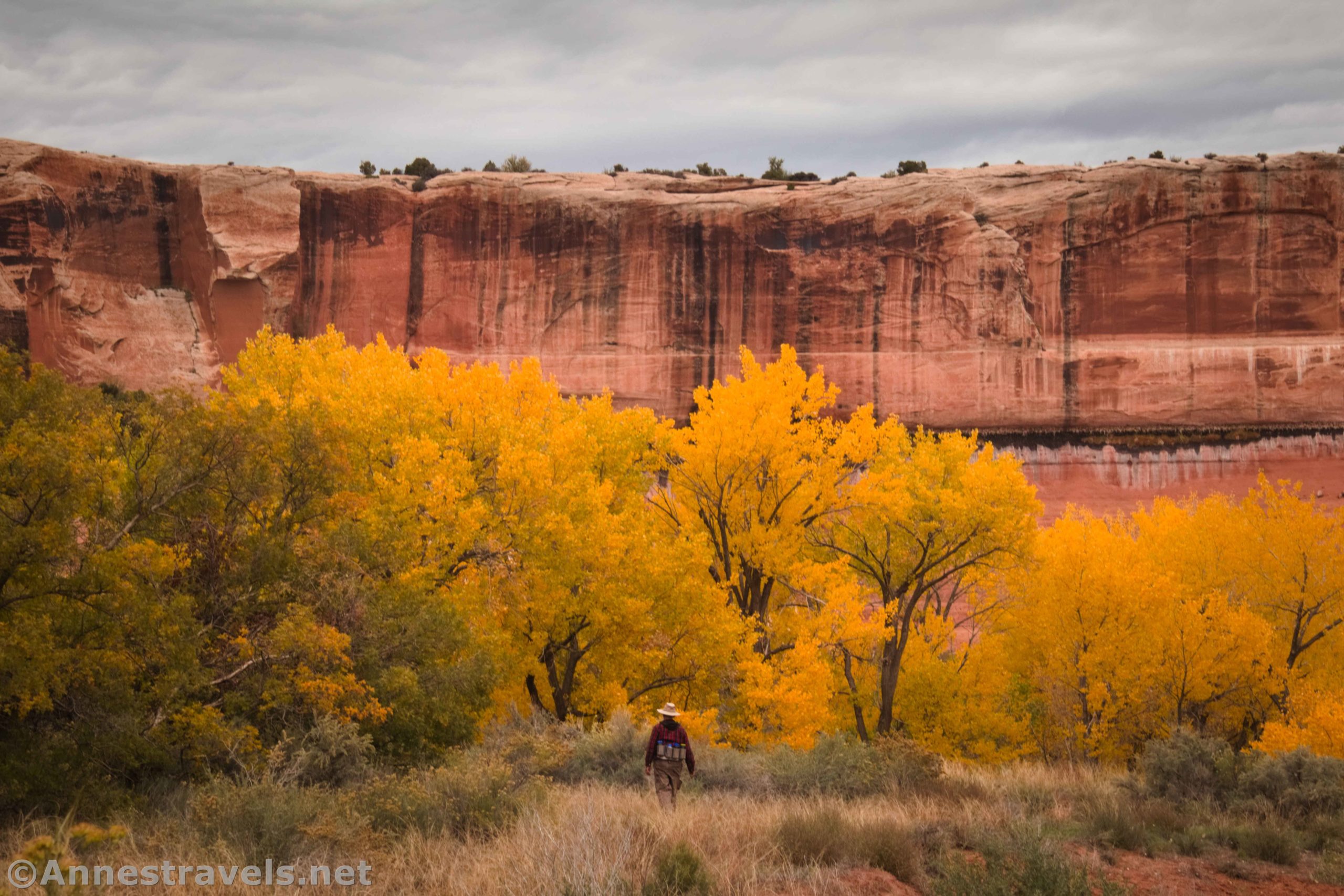
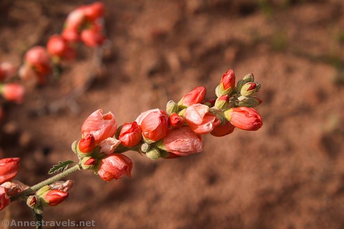
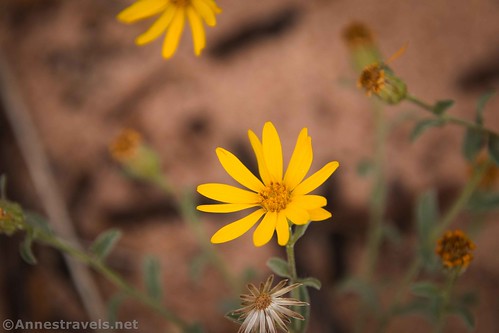
Turn left (downstream/south) on the social trail. In this area, I found quite a few wildflowers in October. So beautiful!
If you’d continued along the pipeline up the ramp on the other side of Salt Wash, you’d eventually get to the Broken Arch Trail in Arches National Park. But that’s another adventure for another day.

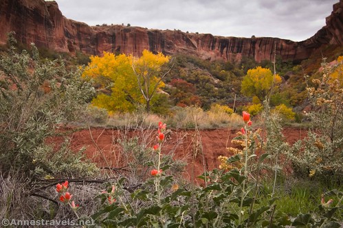
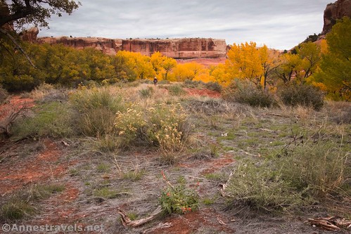
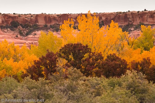
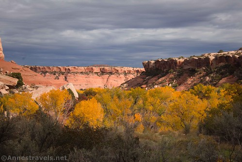
The views from the social trail are pretty good. To the left are rock formations and straight ahead are the La Sal Mountains. The colorful poplar trees made it even more beautiful.
Unfortunately, the social trail doesn’t last. Or maybe it does, but we missed a turn. At any rate, we found ourselves on the brink of the drop down into the true wash of Salt Creek. We scrambled down to try and find another social trail, but it led us into a swampy area.

Somehow or other, you need to find a way to cross Salt Creek to the west side. We ended up wandering for quite some time and missed the entrance to Clover Canyon. Instead, we found ourselves in a brushy area at the outlet of Lost Spring Canyon. If views from there mean anything, Lost Spring Canyon would be very nice.

But we wanted Clover Canyon, so we backtracked up through the thick brush (not as thick as Upper Salt Creek Canyon in Canyonlands National Park!) and then scrambled over some hills and into Clover Canyon.

That explanation was pretty fast. In reality, it took us much longer to figure out where we’d gone wrong, get our bearings, and then bushwack our way back where we wanted to be. At the canyon mouth (wide enough and brushy enough that it can be hard to see from Salt Creek) we ate lunch perched on a little hill.
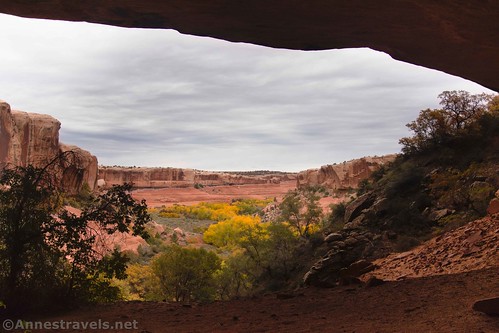
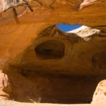
We were able to pick up an animal trail to travel up the southern side of Clover Canyon. At the meeting of canyons, we opted to turn left up into the south fork of the canyon. It wasn’t terribly scenic, though possibly more so than the rest of the canyon. What was exciting was finding an alcove under the westerly of the two pouroffs in the south fork.

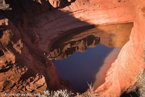
A social trail (human-made, I’d say) travels up into the alcove. The view was nice from up there. I also found a spring and evidence of other visitors – both animals and people.

I trekked back down from the alcove (which is about 0.9 miles from the mouth of Clover Canyon), and we set out for the main fork of Clover Canyon. We had to cross a small creek and then make our own path into the main fork.
Once in the main fork of Clover Canyon, we resolutely turned upcanyon. There are social trails (probably animal trails) that lead up the southern side of the canyon. But it’s not easy hiking. The path takes you down into tiny gullies, then up and over to the next gully, and so on and so forth. You’d better want an adventure for this part of the hike!

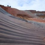
There’s not a whole lot to see as you scramble up and down. There are scrub oak (orange in October) and poplar and other trees (also colorful in October). Sometimes you can see the desert varnish or rocks on the sides of the canyon. I also found some nice cacti. However, I didn’t find any arches. Some showed up on my map, but I guess they’re not visible from the canyon bottom.

We finally pulled up next to an overhang on the northern canyon wall. The canyon wasn’t getting much more scenic and the day was moving on. We decided to cut our losses and head back.

Looking at maps later, we made it most of the way to the end of the canyon. So I don’t think we missed much.

Along the way, I found an old boundary marker for Arches National Park. Apparently, this part of Salt Creek didn’t use to be in the park!

I also found a spring along the northern canyon wall. It wasn’t very large, but I could see where water had stained the rocks on its route down into the creek that flows through Clover Canyon. I heard a waterfall in the canyon, proper, but I couldn’t see it due to the topography around the stream.

About this point, the sun, which had been sulking behind clouds all day, decided to break free. Wow! What a difference a little sunshine makes!

We came to the mouth of Clover Canyon and cast about for a few minutes to find a way across Salt Creek without getting our feet wet.

Then we tried to regain higher ground on the western side of the wash as quickly as possible. It’s just too wet and marshy down by the creek! So we scrambled up the bank and headed upcanyon, finally picking up the social trail again at what one report on my GPS said was mile 6.22 and another report said was mile 7.43.

Either way, the views of the rock formations on the east side of Salt Creek were great, and it was an easy trek back to the pipeline road, an arduous climb back up the road, and then we were back at the parking area!
So that’s a lot of words to say that we dropped into a canyon, walked right past the canyon we were looking for, backtracked, went up the canyon and a sidecanyon, and took a lot of pictures! Enjoy – because honestly, the photos turned out better than the views in real life.

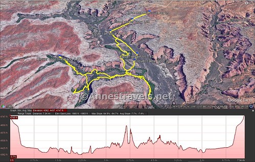
Round Trip Trail Length: My GPS disagrees with itself whether I trekked 7.3 miles or 8.7 miles
Elevation gain: 1,985ft. (4,747ft. to 4,362ft.)
Facilities: None
Fees: None. Technically, you should have a pass to enter Arches National Park, but no one down in here is checking such things.
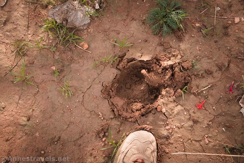
Trail Notes: Be prepared to bushwack, way-find, and generally self-rescue. I didn’t see another soul all day, though it was obvious that other people do hike down in here at times. I also didn’t see any animals, though I did find the prints of an elk, a dog, and a bear. Remember that you’ll need a permit to camp in Arches National Park.
Trail 
![]()
![]()
![]()
![]()
Road ![]()
![]()
![]()
Signs ![]()
![]()
![]()
![]()
Scenery ![]()
![]()
Would I go 100 miles out of my way for this? ![]()
![]()
![]()
Overall Rating: ![]()
![]()
![]()
GPS Coordinates for Clover Canyon
TH: 38.7962160°, -109.5301100° (38°47.77296′, -109°31.80660′ / 38°47’46.3776″, -109°31’48.3960″) (4,750ft.) (0.0)
Arches National Park Boundary: 38.7942540°, -109.5343190° (38°47.65524′, -109°32.05914′ / 38°47’39.3144″, -109°32’03.5484″) (4,637ft.) (0.28)
Left on social trail: 38.7913840°, -109.5395040° (38°47.48304′, -109°32.37024′ / 38°47’28.9824″, -109°32’22.2144″) (4,433ft.) (0.67)
From the mouth of Clover Canyon to the alcove is about 0.9 miles
From the alcove to the overhang is about 0.9 miles
Overhang: 38.7848140°, -109.5495020° (38°47.08884′, -109°32.97012′ / 38°47’05.3304″, -109°32’58.2072″) (4,525ft.) (5.57)
From the overhang to the mouth of Clover Canyon is about 1.2 miles
Where we came up out of Salt Wash: 38.7841800°, -109.5340540° (38°47.05080′, -109°32.04324′ / 38°47’03.0480″, -109°32’02.5944″) (4,407ft.) (7.32)
Regain social trail: 38.7856530°, -109.5335030° (38°47.13918′, -109°32.01018′ / 38°47’08.3508″, -109°32’00.6108″) (4,417ft.) (7.43)
Regain pipeline: 38.7913660°, -109.5395330° (38°47.48196′, -109°32.37198′ / 38°47’28.9176″, -109°32’22.3188″) (4,433ft.) (7.99)
End: 38.7962710°, -109.5299440° (38°47.77626′, -109°31.79664′ / 38°47’46.5756″, -109°31’47.7984″) (4,756ft.) (8.68)
The gpx file for Clover Canyon can be downloaded – please note that this and the GPS Coordinates are for reference only and should not be used as a sole resource when hiking this trail.
Download GPX File size: 200.8 KB Downloaded 433 times
(Note: I do my best to ensure that all downloads, the webpage, etc. are virus-free and accurate; however, I cannot be held responsible for any damage that might result, including but not limited to loss of data, damages to hardware, harm to users, from use of files, information, etc. from this website. Thanks!)
Getting to Clover Canyon
From I-70, take Exit 193, signed for Yellowcat (no services). Turn south on the dirt road (all of my mileages are from the westbound entrance/exit ramps. (I hear there are two other ways of getting in – one from US-191 (I tried that and it was flooded and too sketchy for my van) and another from Owl Draw Road off of UT-128, but neither of these are recommended for 2WD vehicles).

After 6.2 miles, a road will go off on the right (west) at approx. 38.8679514, -109.5499733. Continue straight (south) to mile 7.8, where you want to go left at a Y in the road (approx. 38.8489544, -109.5358285). A half a mile beyond this Y, you will see a couple of old ore hoppers on the left (north) about 38.8479059, -109.5283851. This is the Yellowcat Mine.

Keep driving to mile 9.3. Take the road that goes right (south) about 38.8504449, -109.5107063. At mile 12.0 (approx. 38.8242522, -109.4966222), turn right on a road on the right leads west and south to the trailhead for Lost Spring Canyon after about 4.8 miles from the main road. 2WD vehicles should park here. Continue either on foot or by 4×4 vehicle another 0.8 miles to the parking area beside a fenced-in transformer station and other evidence of the pipeline.
This Week’s Featured Product!
This book boasts 24 trails in Arches National Park – both well-known and slightly off the beaten path. Buy your copy here!


One response to “Exploring to Clover Canyon”
[…] road, following a pipeline down into Arches National Park. Our destination was supposed to be Clover Canyon – we got there, eventually, but that was a lot of bushwacking and slickrock scrambling and […]