
La Boca Arch (and its neighbor, Harold Arch) is often overlooked because it’s a long distance down a dirt road well outside of the typical parks near Moab, Utah. But if you happen to be in the area (say, to see Covert Arch, Winter Camp Arch, Lost Spring Canyon, or Clover Canyon), it makes a quick and fun little stop with a good reward. (Even if we did get a little lost looking for Harold Arch!)
Quick Stats
I’d read that the roads to get to La Boca Arch were sketchy but not bad if you had high clearance. We got halfway down the entrance road and were like, um, no way unless you have 4×4! So we backed out to the main road and parked out of the way of traffic (not that we saw another soul the entire time we were in the area). Walking in on the dirt road wasn’t long or especially hard (0.1 miles).

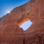
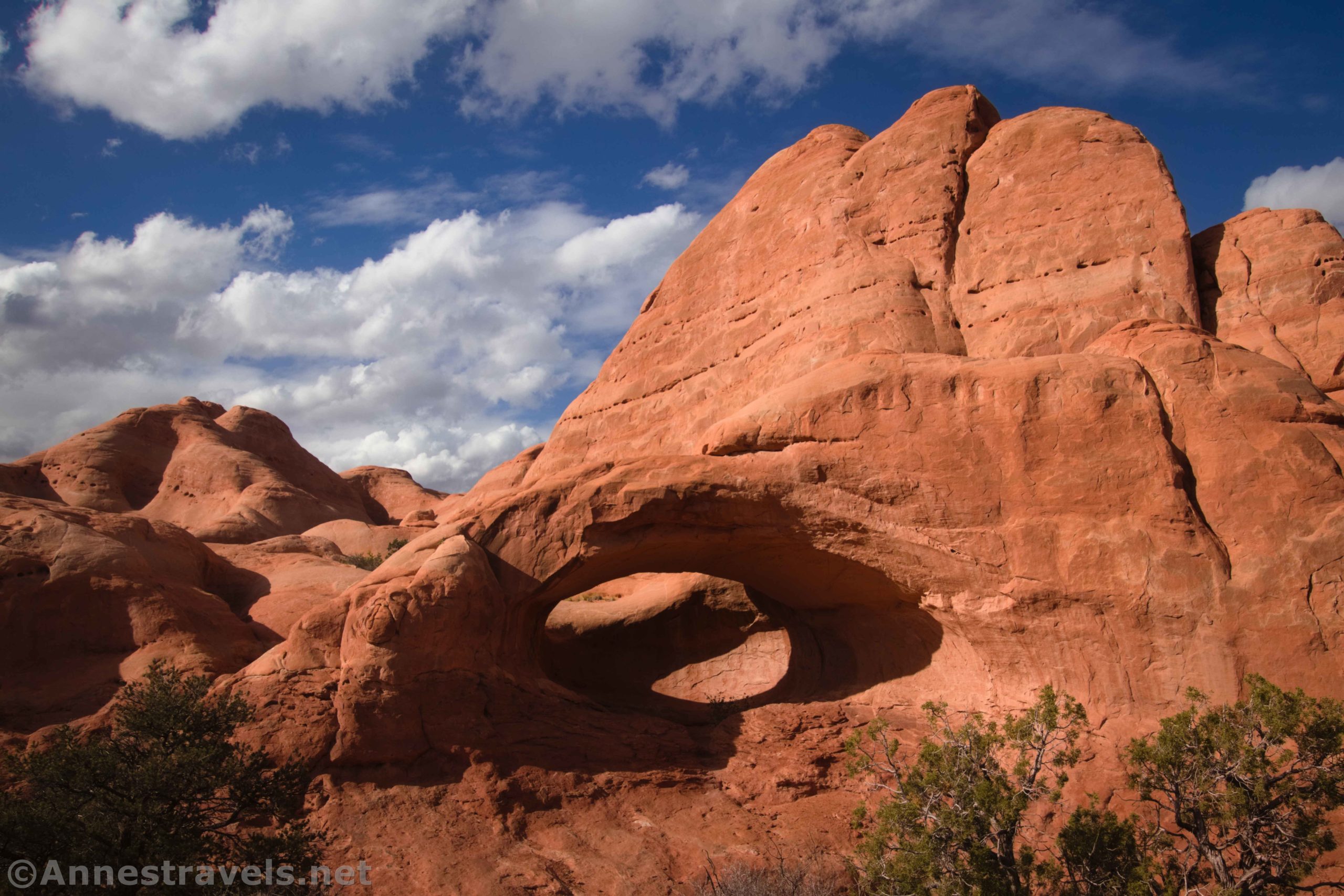
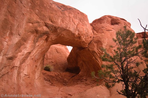
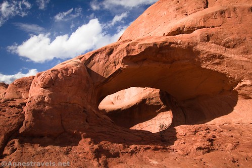
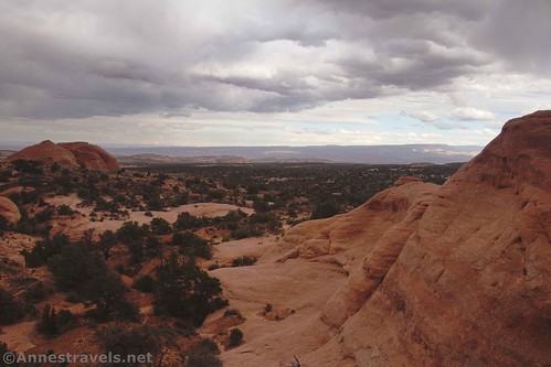
La Boca Arch itself was gorgeous in the evening light. While you can see it from the parking area, you’re welcome to hike down the sandy hill, cross the wash, and then scramble up into it.
Views back to the La Sal Mountains were also great.

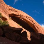
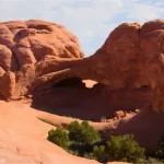
Then we set out to find Harold Arch. I had a couple of issues. First, my directions weren’t very good, and second, while I did have general GPS coordinates, trying to follow them with the topography of sandstone fins wasn’t the easiest. Basically, what you want to do is to head right around the rocks that hold La Boca Arch. Keep walking until you see this on the left:

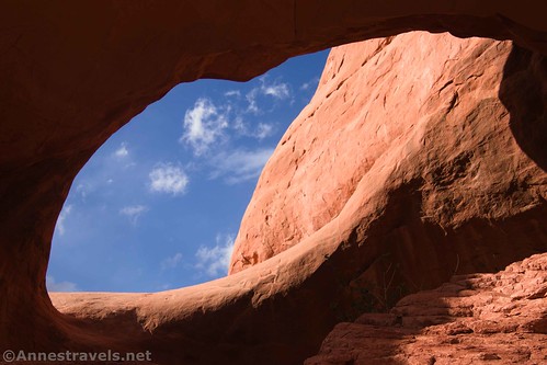
Scrambling up to the arch is fairly simple. I scrambled through and looked out the other side toward the mesas and canyons to the west. There are reasonable views back toward the parking area, too.
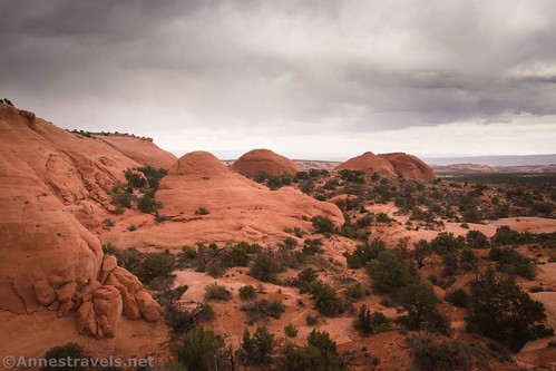
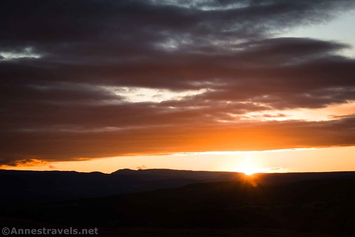
And that’s it! Scramble back down and retrace your steps to the parking area or wherever you were able to park. While the sun went under (and it even spitted rain) while we were looking for Harold Arch, we were treated to a great sunset over the La Sal Mountains that evening.

Round Trip Route Length: 0-1.0 miles (not including hiking in on the access road)
Elevation Gain: 196ft. (5,215ft. to 5,262ft.)
Facilities: None
Fees: None
Trail Notes: “La Boca” means “The Mouth” in Spanish. You’re welcome to climb up into “the mouth.” There is no trail, so make sure you can get back to the parking area. Try to stay in washes, on slickrock, or at least not step on the cryptobiotic soil (black pock-marked dirt areas). You’ll want high clearance to get to the access road and (unless things have changed since 2021) 4×4 to get up the final access road to the parking area. Harold Arch is fun but not especially impressive, so don’t worry if you can’t find it or don’t have an inkling to go searching for it.

Trail 
![]()
![]()
![]()
![]()
Road ![]()
![]()
![]()
Signs ![]()
![]()
![]()
![]()
Scenery ![]()
![]()
Would I go 100 miles out of my way for this? ![]()
![]()
![]()
Overall Rating: ![]()
![]()
![]()

GPS Coordinates for La Boca Arch and Harold Arch
TH: 38.790720,-109.417789 (38°47.44320′, -109°25.06734′ / 38°47’26.5920″, -109°25’04.0404″) (5,238ft.) (0.0)
La Boca Arch: 38.790995,-109.417982 (38°47.45970′, -109°25.07892′ / 38°47’27.5820″, -109°25’04.7352″) (5,244ft.) (225ft.)
Harold Arch: 38.793501,-109.419268 (38°47.61006′, -109°25.15608′ / 38°47’36.6036″, -109°25’09.3648″) (5,272ft.) (0.69)
End: 38.790720,-109.417796 (38°47.44320′, -109°25.06776′ / 38°47’26.5920″, -109°25’04.0656″) (5,238ft.) (1.19)
Turn off of the main road: 38.7867244°, -109.4177166° (38°47.20346′, -109°25.06300′ / 38°47’12.2078″, -109°25’03.7798″)
Turn onto the La Boca Arch access road (we had to park here): 38.7901007°, -109.4168889° (38°47.40604′, -109°25.01333’/ 38°47’24.3625″, -109°25’00.7999″)
Turning onto the sideroad at 38.79365744, -109.4238661 (along the “main” road between the road to Covert Arch and the turnoff for La Boca Arch) takes you out onto a nice slickrock area that’s great for dispersed c*mping.
The gpx file for La Boca Arch and Harold Arch can be downloaded – please note that this and the GPS Coordinates are for reference only and should not be used as a sole resource when hiking this trail.
Download GPX File size: 40.4 KB Downloaded 373 times
(Note: I do my best to ensure that all downloads, the webpage, etc. are virus-free and accurate; however, I cannot be held responsible for any damage that might result, including but not limited to loss of data, damages to hardware, harm to users, from use of files, information, etc. from this website. Thanks!)

Getting to La Boca Arch & Harold Arches Trailhead
The recommended route to La Boca Arch begins at I-70 Exit 193. (I hear there are two other ways of getting in – one from US-191 (I tried that and it was flooded and too sketchy for my van) and another from Owl Draw Road off of UT-128, but neither of these are recommended for 2WD vehicles). Take the exit (it should be signed for Yellowcat) and turn south. All of my mileage will be from the westbound entrance/exit ramps.
After 6.2 miles, a road will go off on the right (west) at approx. 38.8679514, -109.5499733. Continue straight (south) to mile 7.8, where you want to go left at a Y in the road (approx. 38.8489544, -109.5358285). A half a mile beyond this Y, you will see a couple of old ore hoppers on the left (north) about 38.8479059, -109.5283851. This is the Yellowcat Mine.

Keep driving to mile 9.3. Take the road that goes right (south) about 38.8504449, -109.5107063. At mile 12.0 (approx. 38.8242522, -109.4966222), a road on the right leads west to the trailhead for Lost Spring Canyon and Clover Canyon. You want to continue straight (south). Ignore the sideroads, just like you’ve been doing at several points along the route. Pass another sideroad on the right at mile 16.3 (approx. 38.7975664, -109.4352337) that would take you to the trailheads for Winter Camp Arch and Covert Arch.
Keep driving 1.4 miles; take a very sharp left on a sideroad (approx. 38.7867244°, -109.4177166°) for not quite 0.3 miles to another sideroad on the left (about 38.7901007°, -109.4168889°). We had to park here, as turning left up to La Boca Arch would require 4×4 (or at least something not quite so top-heavy as a van). To get to La Boca Arch, turn left up this final sideroad for about 0.1 mile to the parking area.

Today’s Featured Product!
Explore the shorter but no less scenic trails near Moab, Utah, with this guide! Thirty hikes inside and outside of the national parks lead you to and through amazing scenery and interesting sites. Buy your copy here!