
Arches National Park has over 2,000 arches within its borders. Some arches – like the Windows, Double Arch, Delicate Arch, Landscape Arch, etc. – are famous, while others – like Ring Arch – are off the beaten path. Covert Arch is part of this latter category. In fact, Covert Arch barely makes it into Arches National Park: the border is the rim of the canyon, and since the arch branches off of the canyon wall, it’s technically in the park!
Quick Stats
Note: Some of the links in this post are affiliate links. If you click one and purchase something, I may earn a small commission without an extra cost to you.
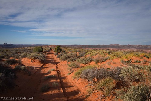
Covert Arch is not easy to access, however. While many of Arches National Park’s arches are found on the west side of the Salt Creek Drainage, Covert Arch (sometimes called Convert Arch) is on the east side. The only “easy” way to access it is to take a high-clearance 2WD dirt road to the parking area for rock climbers exploring the upper reaches of Lost Spring Canyon. From here, you can walk (or drive if you have 4×4) the rough dirt road to a social trail across the desert to the arch. I got lost along the way, but it was still a really great hike if you don’t mind wayfinding and seeing no other human beings.
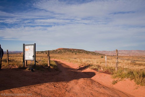
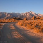
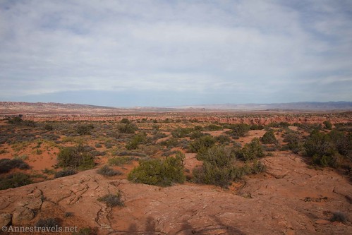
From the high clearance trailhead, you want to keep walking down the dirt road (on the other side of the gate which may or may not be closed). In the early morning, the views were quite good across the grasslands surrounding the road. No wonder ranchers liked this area for cattle back in the early part of the 1900s!

You can see into Arches National Park, proper, from along the road – I spotted the South Window and Landscape Arch was visible from the parking area. At the road junction after a quarter mile, be sure to take the right (more westerly/northerly) of the two roads.

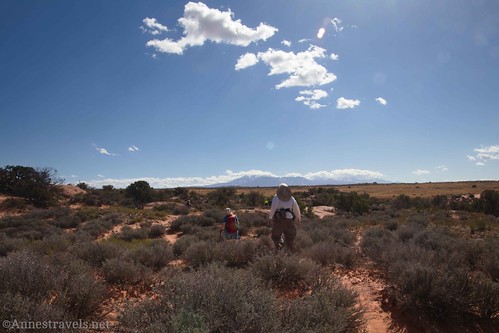
About 0.7 miles from the High Clearance Parking Area, you’ll cross a wash and then pass between two large trees, one on each side of the road. Just after the trees, you’ll likely see several social trails going off on the right. Take one or any of these right (north-ish), off the road, to begin the cross-country section of the hike. Most of these social trails will bring you where you want to go, sooner or later.
Not too long after leaving the road, the sometimes-cairned route crosses a wash. What we should have done here was to go left (downstream) a short distance to pick up the cairns again. But not knowing any better, we went straight across and possibly a bit right to pick up a wash that headed generally west. It was pretty easy hiking and I congratulated myself on finding a good route.
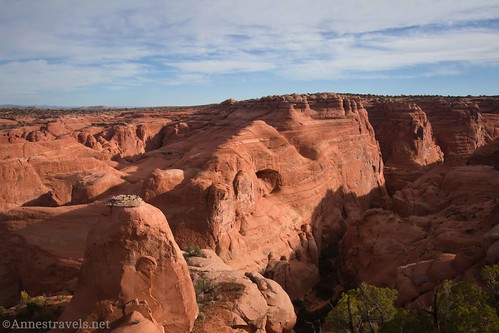
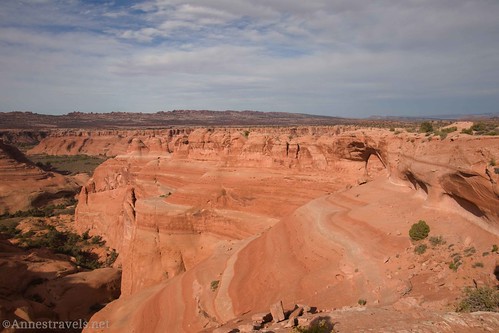
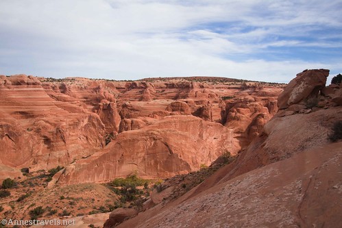
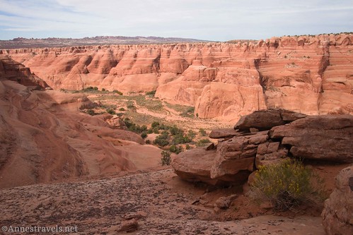
The trouble with this route is that it doesn’t take you to Covert Arch. It gets you to the canyon rim where we had a fantastic view into the upper part of Lost Spring Canyon about mile 1.5. On the one hand, this is not a very good way to get to Covert Arch. On the other hand, this view is amazing and I’m really glad I didn’t miss it.
From the view over Lost Spring Canyon, we turned left generally along the canyon rim. We scrambled over slickrock rises, tried to avoid cryptobiotic soil (please don’t step where others haven’t stepped before – there are rocks and trails you can use), and generally blundered our way west.
With my GPS and a good sense of direction, we ended up above Covert Arch about mile 2.1. Not bad for getting lost along the way!
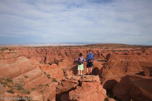
Our first viewpoint was on an outcrop of rock about as close to the arch as you can get and still get a reasonably good view of it. While you can see the arch from here, it’s off to the side a bit.

Several of us walked about 0.3 miles left (south) along the canyon rim and then west to get a view from across the sidecanyon. It’s a very impressive vantage point on the arch.

I’d read that there was a way down onto the rock shelf that passes under Covert Arch. On our way along the rim, I was pretty sure I’d seen where the route went over the edge. It’s near a larger-than-the-others-nearby tree and may be marked by a cairn, near where the canyon rim makes a jag from north-south to east-west.
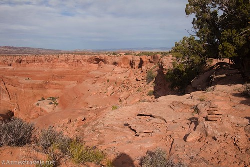
The route looks steep and slippery, but it also looks doable. Per my exploration, this is the one and only possible place along this section of rim to scramble down. Also, note that you’re in Arches National Park as soon as you go over the rim, so national park regulations apply (for example, no rope swings, no drones, no fires on the slickrock, etc.).

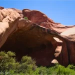
Once down on the shelf, walk north toward Covert Arch. The slickrock slope is steeply sloped at times and is littered with rocks that have fallen off of the cliff above. However, it is walkable. Even one of my group members whose shoes weren’t very grippy made it all right (though I do recommend decent grip for this part of the hike!)
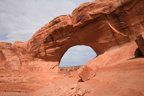
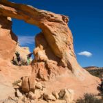
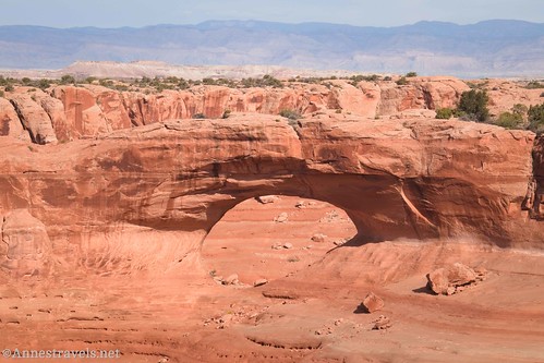
Standing under Covert Arch is awe-inspiring. It’s so much bigger than it looks from above!
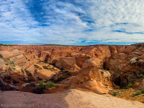
For the best views, walk through Covert Arch and scramble up/over the jumble of rocks on the north side. It’s a little sketchy in places, so take your time and use care. But once up on the rocks and dirt, you can look down on Lost Spring Canyon, into Arches National Park, and get a great view of the rib of rock of which Covert Arch is a part. This is a panorama one of my group members took; it’s hard to get far enough away to take it all in with a single photo.

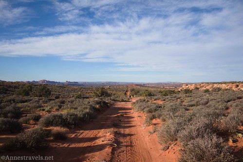
Once you’re finished enjoying the arch, retrace your steps along the shelf and scramble back up to the rim. From here, we were able to pick up the vaguely cairned trail that led us in a much straighter line (and on a much easier path) back to the wash by the road. So if you’re following my GPS track, you’ll probably want to follow my return track to get to Covert Arch!
Round Trip Trail Length: I did 5.2 miles. Not taking in the Lost Spring Canyon View shouldn’t change the mileage significantly.
Elevation Gain: 784ft. (4,721ft. to 5,072ft.) – given GoogleEarth’s ability to deal with cliff edges, I’d guess the elevation gain listed here is fairly generous.
Facilities: None
Fees: None, though technically if you enter Arches National Park you should have some sort of entrance fee. We had our park pass with us and didn’t think about it one way or the other.
Trail Notes: Remember to walk on rock or social trails/washes so you don’t crush the fragile soil in the area. That shouldn’t be too difficult. Use care near the edge of the canyon, as there are no guardrails and it’s a long drop. If you’re canyoneering, you must first get a free day-use permit from Arches National Park (available online). I highly recommend the scramble down to the shelf if you’re up to it – the views are so good from under and around the arch. Most of the hike is in the Lost Spring Canyon Wilderness Study Area, so regular wilderness regulations apply.

Trail 
![]()
![]()
![]()
Road ![]()
![]()
![]()
Signs ![]()
![]()
![]()
Scenery
Would I go 100 miles out of my way for this?
Overall Rating: ![]()
![]()

GPS Coordinates for Covert Arch
TH: 38.779601, -109.481800 (38°46.77606′, -109°28.90800′ / 38°46’46.5636″, -109°28’54.4800″) (5,076ft.) (0.0)
Road Junction: 38.776991, -109.482698 (38°46.61946′, -109°28.96188′ / 38°46’37.1676″, -109°28’57.7128″) (5,080ft.) (0.22)
Leave Road: 38.772771, -109.489766 (38°46.36626′, -109°29.38596′ / 38°46’21.9756″, -109°29’23.1576″) (5,025ft.) (0.71)
Lost Canyon View: 38.778286, -109.497581 (38°46.69716′, -109°29.85486′ / 38°46’41.8296″, -109°29’51.2916″) (4,892ft.) (1.49)
Covert Arch Viewpoint 1: 38.781257, -109.504467 (38°46.87542′, -109°30.26802′ / 38°46’52.5252″, -109°30’16.0812″) (4,804ft.) (2.12)

Covert Arch Viewpoint 2: 38.779963, -109.504889 (38°46.79778′, -109°30.29334′ / 38°46’47.8668″, -109°30’17.6004″) (4,808ft.) (2.41)
Trail down: 38.780348, -109.503296 (38°46.82088′, -109°30.19776′ / 38°46’49.2528″, -109°30’11.8656″) (4,808ft.) (2.60)
Covert Arch: 38.782058, -109.506243 (38°46.92348′, -109°30.37458′ / 38°46’55.4088″, -109°30’22.4748″) (4,786ft.) (2.85)

Regain road: 38.772746, -109.48974 (38°46.36476′, -109°29.38440′ / 38°46’21.8856″, -109°29’23.0640″) (5,025ft.) (4.47)
End: 38.779560, -109.481783 (38°46.77360′, -109°28.90698′ / 38°46’46.4160″, -109°28’54.4188″) (5,077ft.) (5.17)
The gpx file for my trek to Covert Arch (including to the Lost Spring Canyon Viewpoint) can be downloaded – please note that this and the GPS Coordinates are for reference only and should not be used as a sole resource when hiking this trail.
Download GPX File size: 116.0 KB Downloaded 523 times
(Note: I do my best to ensure that all downloads, the webpage, etc. are virus-free and accurate; however, I cannot be held responsible for any damage that might result, including but not limited to loss of data, damages to hardware, harm to users, from use of files, information, etc. from this website. Thanks!)
Getting to Covert Arch
The recommended route to Covert Arch begins at I-70 Exit 193. (I hear there are two other ways of getting in – one from US-191 (I tried that and it was flooded and too sketchy for my van) and another from Owl Draw Road off of UT-128, but neither of these are recommended for 2WD vehicles). Take the exit (it should be signed for Yellowcat) and turn south. All of my mileages will be from the westbound entrance/exit ramps.
After 6.2 miles, a road will go off on the right (west) at approx. 38.8679514, -109.5499733. Continue straight (south) to mile 7.8, where you want to go left at a Y in the road (approx. 38.8489544, -109.5358285). A half a mile beyond this Y, you will see a couple of old ore hoppers on the left (north) about 38.8479059, -109.5283851. This is the Yellowcat Mine.

Keep driving to mile 9.3. Take the road that goes right (south) about 38.8504449, -109.5107063. At mile 12.0 (approx. 38.8242522, -109.4966222), a road on the right leads west to the trailhead for Lost Spring Canyon. You want to continue straight (south). Ignore the sideroads, just like you’ve been doing at several points along the route. The next turn is at mile 16.3 (approx. 38.7975664, -109.4352337); turn right (west). This is Winter Camp Ridge Road. About a tenth of a mile down the road, a second way in from the “main” road enters from the left. Continue west.

The roughest part of the Winter Camp Ridge Road begins about mile 1.75, near an area often used by campers (“Winter Camp” approx. 38.786794, -109.463053; also the trailhead for Winter Camp Arch). The road crosses rocks and slickrock. It’s totally doable by a high clearance van like mine, but we were a bit worried about making it back up the hill and through this section on the way back (we spun just slightly but were fine). Right after this, the road descends steeply to a lower flat area, where the road once again becomes quite passable. At mile 3.0, the road reaches a fence and gate about 38.779601, -109.481800. A small parking area on the left (south) is the High Clearance Trailhead. To the left of the gate is an informational sign about hiking to Covert Arch and climbing in Lost Spring Canyon.

This Week’s Featured Product!
If you’re looking for hikes beyond the traditional routes in Arches National Park, check out this guide. It sticks (generally) to trails and established routes, but it will also likely bring you on adventures most visitors miss out on for lack of knowledge of their existence. Buy your copy here!