

If you counted up how many times we’ve been to each national park in the US, I’m sure you’d find the one we’ve visited the most to be Grand Canyon National Park in northern Arizona. In the last 16 years, I’ve visited it a total of 9 times, and 5 of those visits were on consecutive years! Part of this is due to its central location—if we were visiting northern southwest it was on the way, and if we were visiting the southern southwest, it was still on the way. One member of our group also loves the park, and could just sit for hours staring at the canyon. Anyhow, the canyon itself is beautiful—simply breathtaking—and we’ve enjoyed both walking along the rim and hiking down into the canyon. We’ve never actually made it to Phantom Ranch, but we’ve gotten more than halfway down before going back to the top. (We also hiked to the bottom of the canyon at Toroweep, but I’m not sure that counts…!) My favorite of the trails we’ve hiked into the canyon from the south rim is the South Kaibab Trail, for the simple reason that it has tremendously better views than the Bright Angel Trail. In fact, if you’re going for views, this trail is hard to beat in general—just hiking it is stunning!
(Affiliate links are present on this page.)
To get to the trailhead, you will need to take the free shuttle bus from the Grand Canyon Visitor Center. Actually, there are a lot of other places to park and then ride the shuttle to the visitor center, but the visitor center itself has several huge parking lots where you can park and then ride to most of the other destinations in the park (not Grandview or Desert View; you’ll have to drive your own vehicle to get to these and some other views that aren’t very near Grand Canyon Village). When you get to the visitor center, walk down towards the bus stop that is in the middle of a circle of blacktop (there is a shelter to stand under). You will want the bus going to the South Kaibab Trailhead (currently orange, although at one time it was red). Signs tell which bus stop is right. Stand under the shelter or near the sign that will be on your right if your back is to the shelter. The other sign is where people get off of the bus to get back to their car or transfer to another bus.

Once you’re on the bus, it will take you directly to the parking area for the trailhead. I don’t know why there are so many cars there, since you’re not allowed to drive up there, but I’m guessing they must belong to hikers doing many-day hikes in the canyon. There is a primitive toilet in the parking lot, as well as a couple of picnic tables. The trail begins at the far end of the parking area (it’s hard to miss) and leads to the canyon rim.
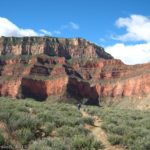
Once you get to the rim, the trail immediately begins to switchback steeply down. The views here are nice enough, but better is to come. At 0.9 miles, you will come to the first viewpoint. This, Ooh-Ahh Point, offers an amazing view of the canyon. There is no sign marking the point, but there are some large, red, flat rocks as well as crowds of people (unless you’re an early riser—we once got there just after sunrise and didn’t see anyone at the point!). If it’s summer, or if you’re not up to much hiking, enjoy the view and then hike back up to the top for a 1.8 mile hike. However, if it’s not too hot and you’re up to some more hiking and tremendous views, keep going for another 0.6 miels to Cedar Ridge. A sign, hitching rail, and primitive toilet mark this area. Again, here the views are awe-inspiring. The views as you were walking down the trail are also quite good, but here you get your first glimpse of what it’s really like to be inside of the canyon. Hiking back up to the ridge from here is a 3 mile (RT) hike. It is not recommended that you go past here in the summer.

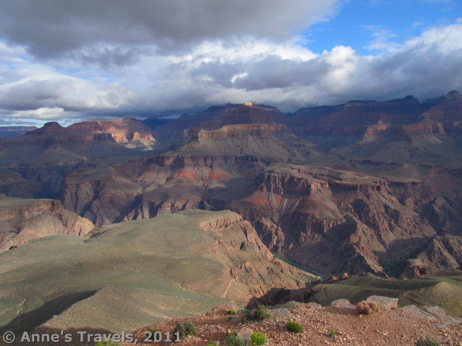
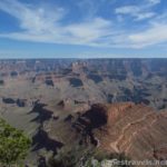
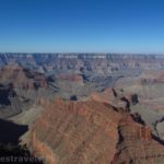
From Cedar Ridge, the trail descends more in a straight line than in switchbacks (up until this point it has been one switchback after another). The views keep opening up in front of and around you, and you realize that this was why you chose not to do the Bright Angel Trail. (That trail goes down a side canyon, so you don’t get the same views you get on the South Kaibab). At several points the wall that you are following breaks up enough for you to see both ways down the canyon. It’s awesome: what you’d see at Yaki Point, only so much better. There are spires, buttes, and just-plain-Grand-Canyon-ness everywhere. This is one of the best parts of the trail, in my opinion. Unfortunately, the day we hiked it, the sun didn’t come out from behind the clouds until we were quite a bit farther down the trail. So, the pictures you see here are less-than-sunny. Oh, well: I’ve always wondered what the Grand Canyon looked like without sun on it!

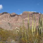
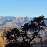
After another 1.5 miles (you’re now 3 miles down the trail) you will come to Skeleton Point, my personal favorite view point on the trail. At the sign/hitching rail, turn left and follow the side trail for a few hundred feet. At the end is an amazing view—it really puts what you’ve seen already to shame. You can actually see the Colorado River from here, as well as up and down the canyon in both directions. The flowers that were here when we visited in May also added to the beauty of the scenery. You’re at a nice height; well below the rim, but still high enough that you’re sort of level with the higher buttes. The lower you go from here, the more you will be below the buttes, and although that’s nice, in some ways I prefer this type of view. Sit back and enjoy the beauty for a little while. It is not recommended that you go farther than this on a day hike.

If you do go farther, only a short distance down the trail you will encounter some switchbacks that make just about every backpacker shutter in their hiking boots: the Great Whites. These are some of the steepest switchbacks on the entire trail; don’t try them unless you really want to have to climb back up them! Actually, just before the Great Whites (which, by the way, get their name from the color of the sand on the trail—you’ve been hiking over orange/red sand ever since you set out, but suddenly the trail is covered in white sand) you will see a little peek-a-boo view through the wall you are following. This was a cool little feature, so if you want to walk down to it from Skeleton Point, it’s less than 0.1 miles down the trail.
After the Great Whites, the trail levels out a little, and then gradually descends to the Tonto Trail, where there is a primitive toilet and an emergency phone (at the “tip off”). This is as far as I’ve ever gone, but it looked like just beyond the toilet the trail began to steeply descend into the inner canyon. The Tonto Trail is right in between the outer and inner canyons. From here, you can either take the Tonto Trail to another trail to climb back to the rim (only if you’re in the mood for a very, very long hike!), or you can climb back up the way you came (approximately an 8.8 mile RT hike). I continued down to the Colorado River about 10 years later.

The choice of how far you go down the South Kaibab Trail is really up to you, and will depend on your hiking ability, the weather, and the time of year. In the summer, this trail is incredibly hot, with virtually no shade, so you won’t want to go very far. Also, if a thunderstorm is approaching, you probably won’t want to go very far…these can be dangerous if you’re caught in them. Also, remember that there is no water available on the trail, so bring plenty, no matter what your hiking ability, weather, or time of year! The round trip distances, if you go to these points, are as follows: Ooh-Aah Point: 1.8 miles; Cedar Ridge: 3 miles; Skeleton Point, 6 miles; Tip Off (Tonto Trail), 8.8 miles.
Trail 
![]()
![]()
Road
Signs
Scenery
Would I go 100 miles out of my way for this?
Overall Rating: 
This Week’s Featured Product!
If you want more trails in Grand Canyon, check out this book. It covers nearly 30 different hikes within and around the canyon.
6 responses to “So You Wanna Go Down in the Canyon… The South Kaibab Trail”
[…] Note: The Tonto Trail actually transverses most of the canyon. However, I choose to hike the trail from the South Kaibab Trail to the Bright Angel Trail (about a 4.4 mile (7 km) section of the Tonto Trail and a 13.1-mile (21 km) RT loop). The Tonto Trail intersects the South Kaibab Trail 4.4 miles (7 km) from the South Kaibab Trailhead, after the Great Whites and near the “tip-off point” (primitive toilet, hitching rail, and emergency phone). I reached this junction about 8:15am and turned left down the Tonto Trail – the junction is fairly well-marked. You can read about my trek down the Tonto Trail here. […]
[…] for a very long time. As I said above, the view is quite different than what I had seen on the South Kaibab Trail because this is a different section of the […]
[…] South Kaibab Trail to Skeleton Point. If you can only do one hike into the Grand Canyon, this is the one. Spectacular views from the first continue to abound and improve for the 1.5 miles down to Skeleton Point, a popular destination for dayhikers. Here are views of the canyon’s many temples, as well as the rest of the canyon. Wow! And if you’re really feeling adventurous, continue down the infamous “Great Whites” (steep switchbacks) another 3 miles to the “Tip Off Point” at the edge of the inner canyon. 3 miles RT. […]
[…] South Kaibab / Tonto / Bright Angel Loop, Grand Canyon National Park, AZ […]
[…] South Kaibab–Tonto-Bright Angel Loop, Grand Canyon National Park, Arizona. […]
[…] the South Kaibab Trail to the Tonto Trail and then up the Bright Angel Trail in Grand Canyon was a “must do” hike a […]