
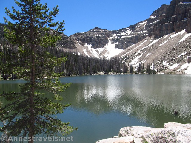
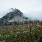
A pine tree at Ibantik Lake
One of the great things about hiking the Uinta Mountains in the early summer is that there is still snow on the peaks. Of course, that might mean there is still snow on the trails, too, but if you can balance the snow on the peaks with the snow on the trails, you’ve got yourself some winner hikes. One such winner is the hike to Ibantik Lake. While only 4.5 miles from a trailhead, it feels like it’s deep in the wilderness. And with 5+ lakes along the way, plus some great mountain views, it’s an alpine paradise!
Quick Stats
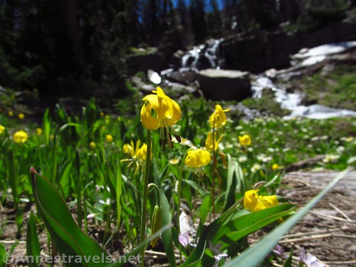
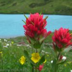
Glacier lilies near the inlet to Ibantik Lake
We hiked to Ibantik Lake the second week of June after a fairly light snow year. The bugs weren’t too bad (yay!), and it was cool enough that we wanted our jackets.

Pond Lake near the trailhead
The trail begins at the Crystal Lake Trailhead. There is a large trail network that begins here, so be sure to take the Wall Lake Trail #229 toward Notch Mountain and Clyde Lake. The path passes through a swampy section between Ponds Lake and Lily Lake. I didn’t dally; it seemed like a haven for mosquitos. The trail generally follows the stream on a gentle upward through the forest.
Waterfall below Wall Lake
A mile from the trailhead, we could hear a waterfall on our right. The trail passes near the waterfall that drains Wall Lake (the lake has been dammed, so the waterfall is quite picturesque but not exactly natural). Keep walking up the hill, and you’ll be on the shores of Wall Lake.

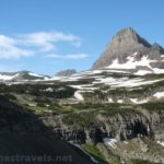
Wall Lake with the unnamed peak beyond
After admiring the view of Wall Lake and an unnamed 10,513ft. peak, turn right to cross over the lake’s outlet and connect to the Notch Mountain Trail. Turn left to continue up toward Hope Lake (the sign may not mention the lake by name). The trail passes through some very nice forests; at that time of year, the avalanche lilies were out in force. They were so beautiful, especially the ones by Hope Lake about mile 2.0.
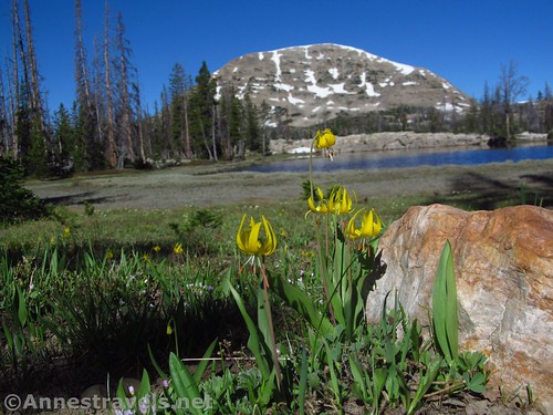
Glacier lilies at Hope Lake
A boardwalk goes around Hope Lake, then the well-worn trail continues upward through the thinning forest. Reach a trail junction at mile 2.6; turn right toward the Notch. The trail steepens to rise into a land of boulders and a few trees.

Views from The Notch – there are quite a few lakes that didn’t make it into this picture
The views from the trail around the Notch are glorious. So many lakes dot the valleys below the mountains. With the snow still on the peaks, there’s incredible beauty on both sides of the pass!

Lovenia Lake from The Notch
We crossed over the other side and found our first snow patch. Actually, much of the trail on the north side of the Notch was snow covered. I didn’t know exactly where the trail was, but we could see enough that it wasn’t too hard to figure out which way to go.

White marsh marigolds and snow along the trail
Once we were down in the valley, the snow tapered off and we were on mostly dry trails again. There were more avalanche lilies and white marsh marigolds. We eventually passed Lovenia Lake (mile 3.6), and half the party decided to wait for us there while the rest of us hurried down to Ibantik Lake. All I can say is that they missed the second best scenery on the hike. Lovenia is just an alpine pond, but Ibantik is beautiful.

Lovenia Lake
Just about the time we thought we couldn’t go much further (time restraints, etc.) a sign on the right indicated that we had arrived at Ibantik Lake. I struck off-trail down to the lakeshore (or the rocks above the lake, more accurately) and arrived just about mile 5.0.

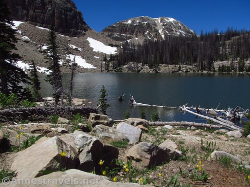
Ibantik Lake
The view across the lake is lovely. Steep cliffs rise beyond the scree along the shore, and snow was still prominent on the north sides of the cliffs. Meanwhile, the lake sparkled in the sunshine. Beautiful!

The Ibantk Lake Outlet
Several of us scrambled left along the lakeshore, then we crossed the spillway (Ibantik Lake is dammed, too) in relative safety and walked across the dam. Trails lead around the far side of the lake to various campsites. I was following another group member, but we got separated, and he went back. By the time I realized that I wasn’t following him anymore, I was well more than halfway around the lake. So it only made sense to keep going, right?
Views from the far side of the lake
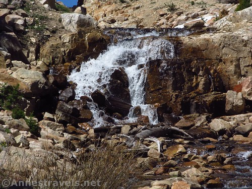
About as far as you can easily go around the lake is to the inlet stream. Walking up the stream is a soggy experience in the early summer, but there is a lovely little waterfall (natural, I think).

The waterfall in the lake’s inlet
I came back down, got my feet good and wet trying to cross the inlet (it’s soggy – thankful for hiking boots!) and finally reached the scree slope along the southern end of the lake. Scrambling it was pretty typical for a scree field (expect big rocks, somewhat stable). There was some snow where the north-facing cliffs had shadowed the scree, but I was able to skirt it (I wasn’t going to climb over it!) This was by far the most difficult part of the hike around Ibantik Lake, but I made it around to the corner where the forest began again and was able to find easier scrambles / social trails back to where my group was patiently waiting (thankfully the view kept them at least somewhat occupied!)

Snow and scree on the southern shore of Ibantik Lake
After that, we began the trek back the way we had come. It was a bit of a long day hike (though somehow my GPS was only reading 9 miles when we got back to the trailhead – but that didn’t count going around the lake). But the views were epic enough to make it well worth the effort!
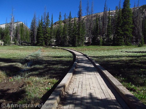
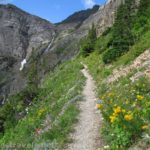
Curving boardwalk around Hope Lake
Round Trip Trail Length: My GPS would suggest 9.0 miles to 10.0 miles
Vertical Change: 625ft. (9,974ft. to 10,599ft.)
Facilities: Primitive restrooms in the parking area; campgrounds and picnic areas nearby (the water isn’t turned on until later in the season)
Fees: $6/1-3 days; $12/7 days. National Park & Federal Recreation Passes and Uinta National Forest Annual Pass also accepted.
Trail Notes: The parking area (especially!) and the trail / lake can be very crowded in the summer. The views of the area are best from the Notch, so even if you hike that far you’ll have a great hike.

Wall Lake from The Notch
Trail 
![]()
![]()
Road
Signs
Scenery
Would I go 100 miles out of my way for this?
Overall Rating: 

An unnamed pond along the trail between Lovenia Lake and Ibantik Lake
GPS Coordinates for Ibantik Lake
Trailhead: 40.6819333°, -110.9629500° (N40° 40.916′ W110° 57.777′ / 40°40’54.9600″, -110°57’46.6200″) (9,974ft.) (0.0) (9.08)
Waterfall Viewpoint: 40.6936833°, -110.9s608000° (N40° 41.621′ W110° 57.648′ / 40°41’37.2600″, -110°57’38.8800″) (10,059ft.) (0.99)
Waterfall: 40.7122667°, -110.9485833° (N40° 42.736′ W110° 56.915′ / 40°42’44.1600″, -110°56’54.9000″) (10,065ft.) (???)
Notch Trail Junction: 40.6946000°, -110.9600667° (N40° 41.676′ W110° 57.604′ / 40°41’40.5600″, -110°57’36.2400″) (10,126ft.) (1.19)
Hope Lake: 40.7011667°, -110.9531333° (N40° 42.070′ W110° 57.188′ / 40°42’04.2000″, -110°57’11.2800″) (10,313ft.) (2.08)
Trail Junction: 40.7047667°, -110.9573333° (N40° 42.286′ W110° 57.440′ / 40°42’17.1600″, -110°57’26.4000″) (10,432ft.) (2.59)
Notch: 40.7072000°, -110.9585167° (N40° 42.432′ W110° 57.511′ / 40°42’25.9200″, -110°57’30.6600″) (10,599ft.) (2.95)
Lavona Lake: 40.7129333°, -110.9592833° (N40° 42.776′ W110° 57.557′ / 40°42’46.5600″, -110°57’33.4200″) (10,304ft.) (3.6)
Leave Trail: 40.7152333°, -110.9515833° (N40° 42.914′ W110° 57.095′ / 40°42’54.8400″, -110°57’05.7000″) (10,105ft.) (4.45)
Ibantik Lake: 40.7151333°, -110.9510500° (N40° 42.908′ W110° 57.063′ / 40°42’54.4800″, -110°57’03.7800″) (10,105ft.) (4.51)

Looking back across Ibantik Lake not far from the inlet stream
The gpx file for Ibantik Lake can be downloaded – please note that this and the GPS Coordinates are for reference only and should not be used as a sole resource when hiking this trail.
Download GPX File size: 172.4 KB Downloaded 385 times
(Note: I do my best to ensure that all downloads, the webpage, etc. are virus-free and accurate; however, I cannot be held responsible for any damage that might result, including but not limited to loss of data, damages to hardware, harm to users, from use of files, information, etc. from this website. Thanks!)

White marsh marigolds along the trail
Driving Directions
From I-80E, east of Salt Lake City, take Exit 146 toward US-40 East toward Heber City and Vernal. After 0.7 miles continue on US-189 / US-40E for another 0.3 miles. Take Exit 4 toward Park City and Kamas; turn left onto UT-248E. After 11.4 miles, turn left onto UT-32 (there’s a 7-Eleven on the corner); only 0.2 miles later, turn right onto UT-150 (next to the Chevron). A ranger station is nearby if you need information – by some fluke, it was closed for staff training the day we tried to visit. Continue on UT-150 for 25.4 miles and turn left onto the road marked for Crystal Lakes Trailhead. After 0.7 miles, turn right, then arrive at the parking area after 0.4 miles (the route is a little hard to follow; be sure to stay on the main road and not someone’s driveway).

One of the unnamed peaks of Notch Mountain from the far side of Ibantik Lake
From I-80W (west of Evanston, Wyoming), take Exit 5 in Evanston toward UT-150. Turn left onto WY-150, also known as Front Street. After 22.6 miles, the road will change names to UT-150. Continue to drive up into the mountains for another 25.6 miles to the top of Bald Mountain Pass. Continue down the other side of the pass another 3.7 miles to turn right on the road marked for the Crystal Lakes Trailhead. After 0.7 miles, turn right, then arrive at the parking area after 0.4 miles (the route is a little hard to follow; be sure to stay on the main road and not someone’s driveway).
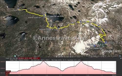
Visual trail map and elevation profile for my hike to Ibantik Lake
Zoom map out to browse nearby hikes & places of interest
This Week’s Featured Product!
This book, with 99 hikes in the Uinta Mountains, may be one of the most thorough books about hiking in the Uintas. It also includes good fishing spots, maps, and photos of the hikes.

Pingback: Sneak Peak: Southwestern Variety at its Finest - Anne's Travels