
Taking the Long Canyon Trail up Gold Hill is shorter than taking the official Gold Hill Trail from Bull-of-the-Woods Pasture. However, this means it skips a lot of the scenic aspect of the longer trail, while offering a stream-side experience the longer route doesn’t even begin to dream of. Many hikers try to cut their losses by taking one trail up and the other down – that’s exactly what I did when I climbed Gold Hill last summer, but since this is a perfectly viable trail up the peak, I’ll describe it as though you’re hiking up Gold Hill via Long Canyon from the parking area.
Quick Stats
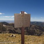
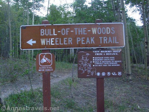
The trail begins at the Bull-of-the-Woods Trailhead in the Taos Ski Valley. To get to the trailhead from the parking area, climb the trail uphill to the road above the parking area. Cross the road and look for the big brown sign announcing the Wheeler Peak Trail and Bull-of-the-Woods. A sign may call it the Wheeler Peak Trailhead, but while a trail does go to Wheeler Peak from here, the more popular trailhead for Wheeler Peak is higher up the gravel road. A second sign says, “Columbine-Twining National Recreation Trail” and has arrows for “Wheeler Peak Tr. 90” and “Bull-of-the-Woods Pasture 1.8 Mi.” (as in miles). Follow this rocky trail uphill (you’ll pass a primitive restroom very shortly after the trailhead – perfect for that last-minute pit stop!)
Fairly quickly, you’ll pass a “Horse Trail” junction. There are several of these – it really doesn’t matter which trail you take; they’ll both get you up the mountain. The horse trail is slightly longer and slightly less rugged than the hiker trail (I took the horse trail on the way down and the GPS track reflects this), so take either trail.
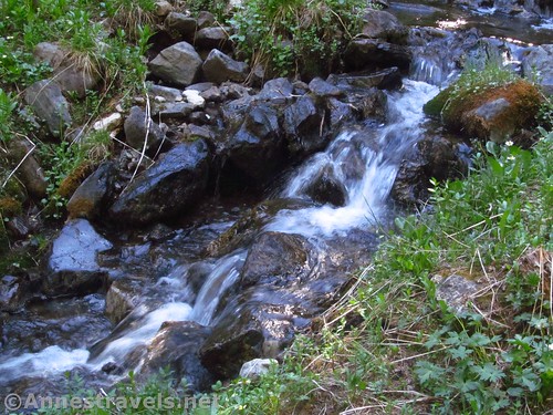
Cross the stream that travels down Long Canyon (very easy in late May after 25% snowpack the winter before) about mile 0.75; about a tenth of a mile later, the Long Canyon Trail strikes left. Turn left to ascend generally along the stream.
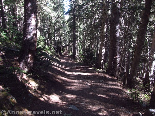
There was quite a bit of windfall across the path when I hiked it. Very likely it was cleared later in the season (May really is early for the Taos Ski Valley, especially most years) but it definitely slowed our progress to scramble over tree trunks, sometimes every 50 feet or so, sometimes a quarter mile apart.
The trail really is a bit idyllic as it travels above the stream. It’s always a tinkling sound, and there are several waterfalls and quite a few wildflowers (in late May).
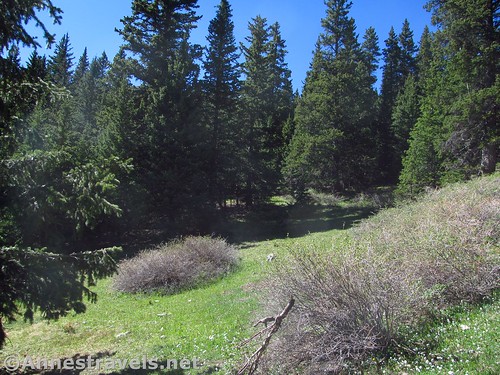
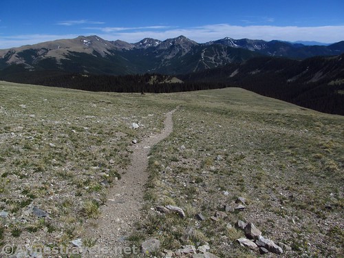
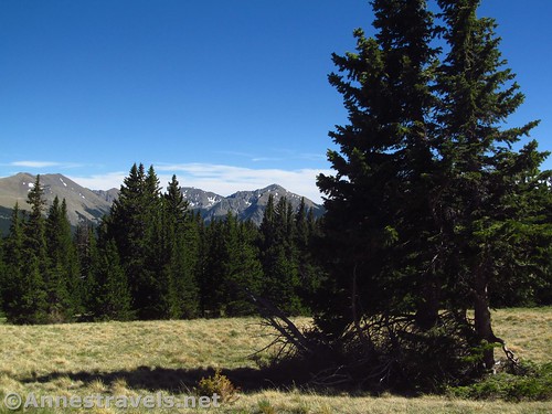
As the trail reaches the head of Long Canyon, it turns a bit to the north and then switchbacks up above the treeline. Right at the treeline, it meets a connector trail that will take you over to the Gold Hill Trail. Ignore the connector and turn left (straight aka uphill) to continue upward toward the ridge that contains Gold Hill.
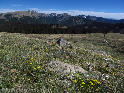
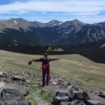
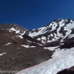
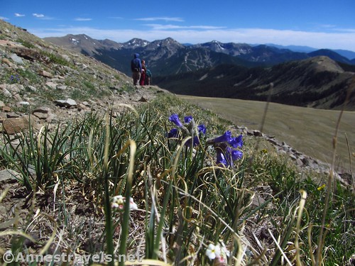
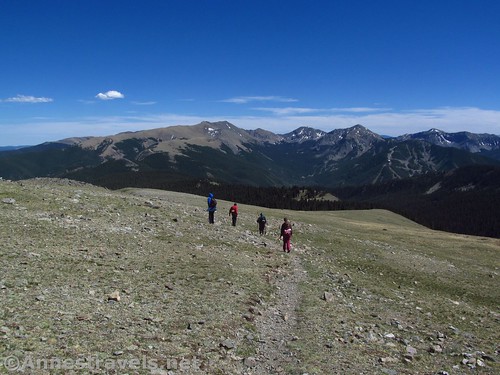
It’s very beautiful up here; that “top-of-the-world” feeling that makes me return again and again to high alpine peaks. You are above the trees, so it’s just you and the tundra – and possibly a few bighorn sheep (we spotted a few over the next ridge).
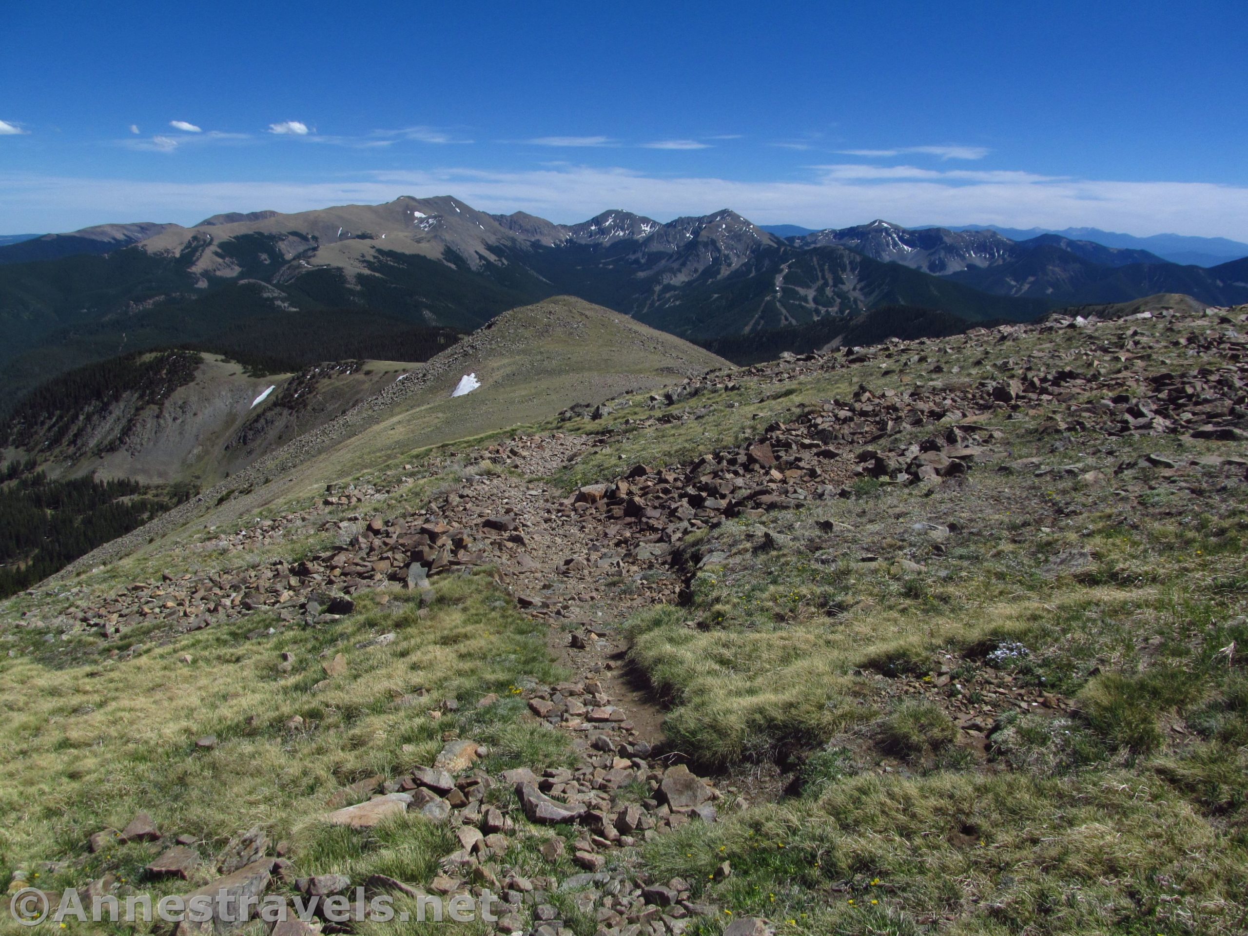
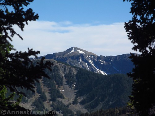
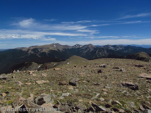
We continued up toward what appeared to be Gold Hill (actually a false summit). The trail wound around several false summits, always higher and higher, then up Gold Hill, itself.
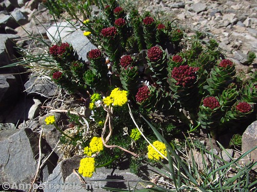
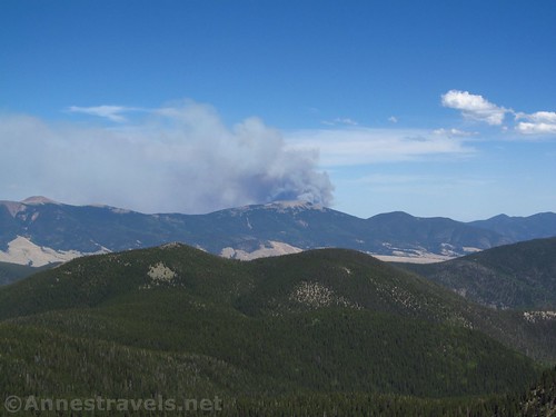
The views just kept getting more glorious. Around our feet were rocks set into the ground as our trail, and wildflowers bloomed among the nearby rocks and stones. It was idyllic, beautiful, and oh, so peaceful, despite the smoke beginning to billow from behind Tunnel Hill.
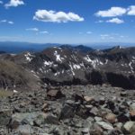
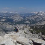
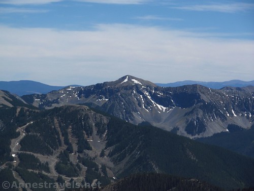
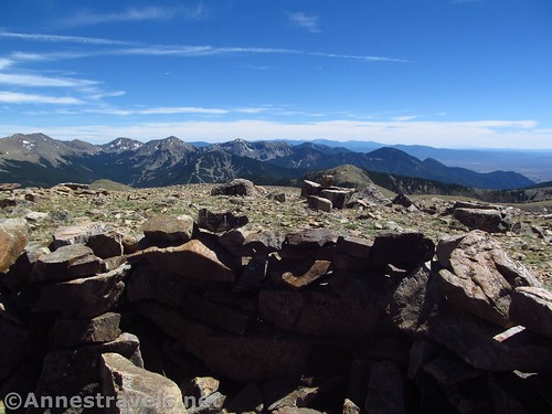
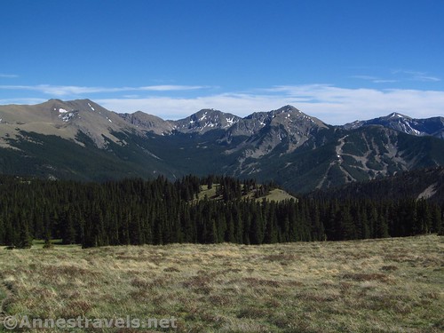
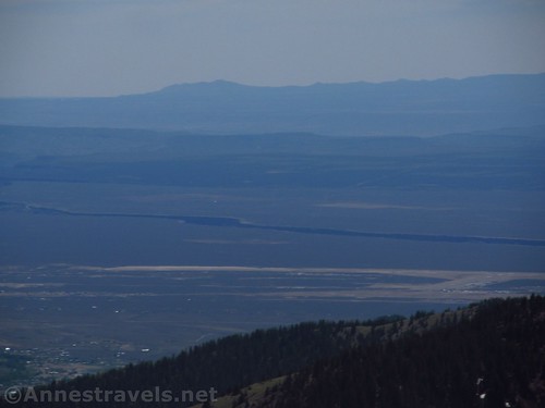
The top of Gold Hill about mile 5.3 probably doesn’t have the best views of the entire hike, and the wind was so fierce, we were thankful for the rock windblock on the peak (you will have to walk left, off the trail, to reach the official peak), but the views open up north, which you haven’t seen before. There are views all the way into Colorado from up here, as well as back down to the peaks around the Taos Ski Valley. Beautiful!
From here, you can choose to take the same trail back, descend to Goose Lake (about 1.5 miles from the top of Gold Hill), or take the Gold Hill Trail back to the Taos Ski Valley and the Bull-of-the-Woods Trailhead via Bull-of-the-Woods Pasture (longer than returning via Long Canyon, but extremely scenic / pleasant to hike)
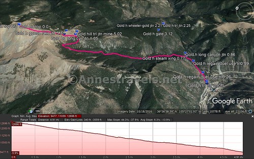
Round Trip Trail Length: 10.6 miles out & back via Long Canyon; 12.6 miles out & back via Bull-of-the-Woods Pasture; 11.6 miles as a semi-loop up one trail and down the other (my recommendation)
Net Elevation Change: 3,228ft. (9,473ft. at the trailhead to 12,701ft. at the top of Gold Hill)
Facilities: Restrooms and visitor services near the trailhead in the Taos Ski Valley
Fees: None
Trail Notes: Note that this is a very high-elevation hike; you would be wise to acclimate a bit in Colorado or other nearby hikes before trying out this one. I highly recommend the loop option, though I have a feeling the Long Canyon Route is less steep than the Gold Hill Route (but maybe that was because I was going down and not up, lol).
Trail 
![]()
![]()
Road ![]()
Signs ![]()
Scenery
Would I go 100 miles out of my way for this?
Overall Rating: ![]()
GPS Coordinates for Gold Hill via Long Canyon
Parking: 36.5965000°, -105.4496167° (N36° 35.790′ W105° 26.977′ / 36°35’47.4000″, -105°26’58.6200″) (9,530ft.)
Gold Hill Peak: 36.6433167°, -105.4557000° (N36° 38.599′ W105° 27.342′ / 36°38’35.9400″, -105°27’20.5200″) (12,693ft.) (0.0)
Lobo Trail Junction: 36.6320500°, -105.4530000° (N36° 37.923′ W105° 27.180′ / 36°37’55.3800″, -105°27’10.8000) (12,098ft.) (0.86)
Long Canyon Junction: 36.6298667°, -105.4512000° (N36° 37.792′ W105° 27.072′ / 36°37’47.5200″, -105°27’04.3200″) (11,944ft.) (1.05)
Trailhead: 36.5971167°, -105.4490000° (N36° 35.827′ W105° 26.940′ / 36°35’49.6200″, -105°26’56.4000″) (9,592ft.) (5.29)
The gpx file for Gold Hill from the top of Gold Hill back to the Bull-of-the-Woods Trailhead via Long Canyon can be downloaded – please note that this and the GPS Coordinates are for reference only and should not be used as a sole resource when hiking this trail. For the gpx from the trailhead to Gold Hill via Bull-of-the-Woods Pasture, click here.
Download GPX File size: 98.3 KB Downloaded 424 times
(Note: I do my best to ensure that all downloads, the webpage, etc. are virus-free and accurate; however, I cannot be held responsible for any damage that might result, including but not limited to loss of data, damages to hardware, harm to users, from use of files, information, etc. from this website. Thanks!)
Getting to the Gold Hill Trailhead
From Taos, New Mexico, drive north on US-64W. Outside of town, turn right on NM-150N, turning away from the Rio Grande Gorge Bridge (which is a worthy destination unto itself.) (If you’re coming in from the north, take this turn where NM-522S meets US-64 – turn left toward the Taos Ski Valley).
Follow the NM-150N for almost 15 miles (a GPS is useful, but not required). You’ll pass through typical northern New Mexico plains, then enter an alpine canyon more fit for Colorado – it’s a beautiful (if steep) drive. Just before the main part of the ski valley, a gravelish road / hill / parking area will go off on the left. Just before or after this, park in one of the parking areas, then walk up the gravelish road / hill / parking area to the trail, on the left (north) side of the road with a prominent brown sign about the Wheeler Peak Trail and Bull-of-the-Woods.
Zoom map out to browse nearby hikes & places of interest
This Week’s Featured Product!
Looking for even more hikes in the Taos and Taos Ski Valley vicinity? This book offers a wide variety of trails in the surrounding region.