
For three weeks now, we’ve been talking about climbing Wheeler Peak. We visited Williams Lake (a worthy short side trip from the Wheeler Peak Trail), discovered Williams Falls (a little lengthier, but still worth visiting), and then up Mount Walter, a beautiful little high point on the same ridgeline as Wheeler Peak. So today, I think it would be great to actually get to Wheeler Peak!
Quick Stats
(Affiliate links are present on this page.)
Hike up the trail to the Wheeler Peak Trail Junction (as described here – Williams Lake Trail) and turn left, or continue to Williams Lake (as described here – Williams Lake Trail) and then either retrace your steps to the Wheeler Peak Trail Junction or go up through the forest (as described here – Mt. Walter Trail) to connect to the Wheeler Peak Trail further up. Either way, you want to be hiking upward on the Wheeler Peak Trail.
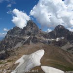
Follow the directions (here – Mt. Walter Trail) up to the Wheeler / Walter saddle. You can turn left (as described here – Mt. Walter Trail) as a 0.2 mile RT side-trek to Mount Walter. However, right now, we’re going to Wheeler Peak, so we’re going to turn right along the ridgeline.
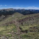
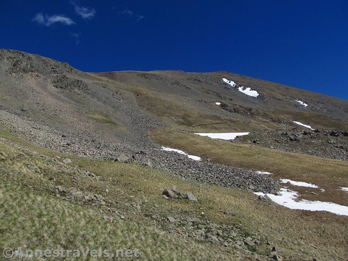
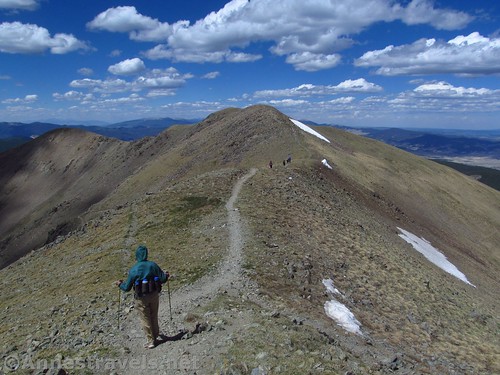
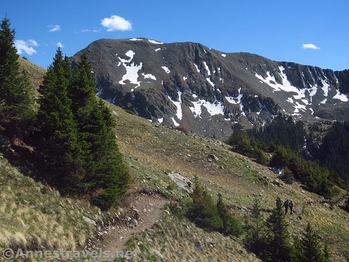
The trail drops slightly on the far side of the ridge to go around a false summit or two (thank you to the trail builders that we don’t have to hike over these humps!) and then rises steeply to the ridgeline again to turn left up to the top of Wheeler Peak.
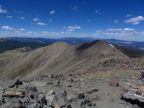
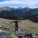
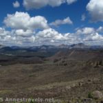
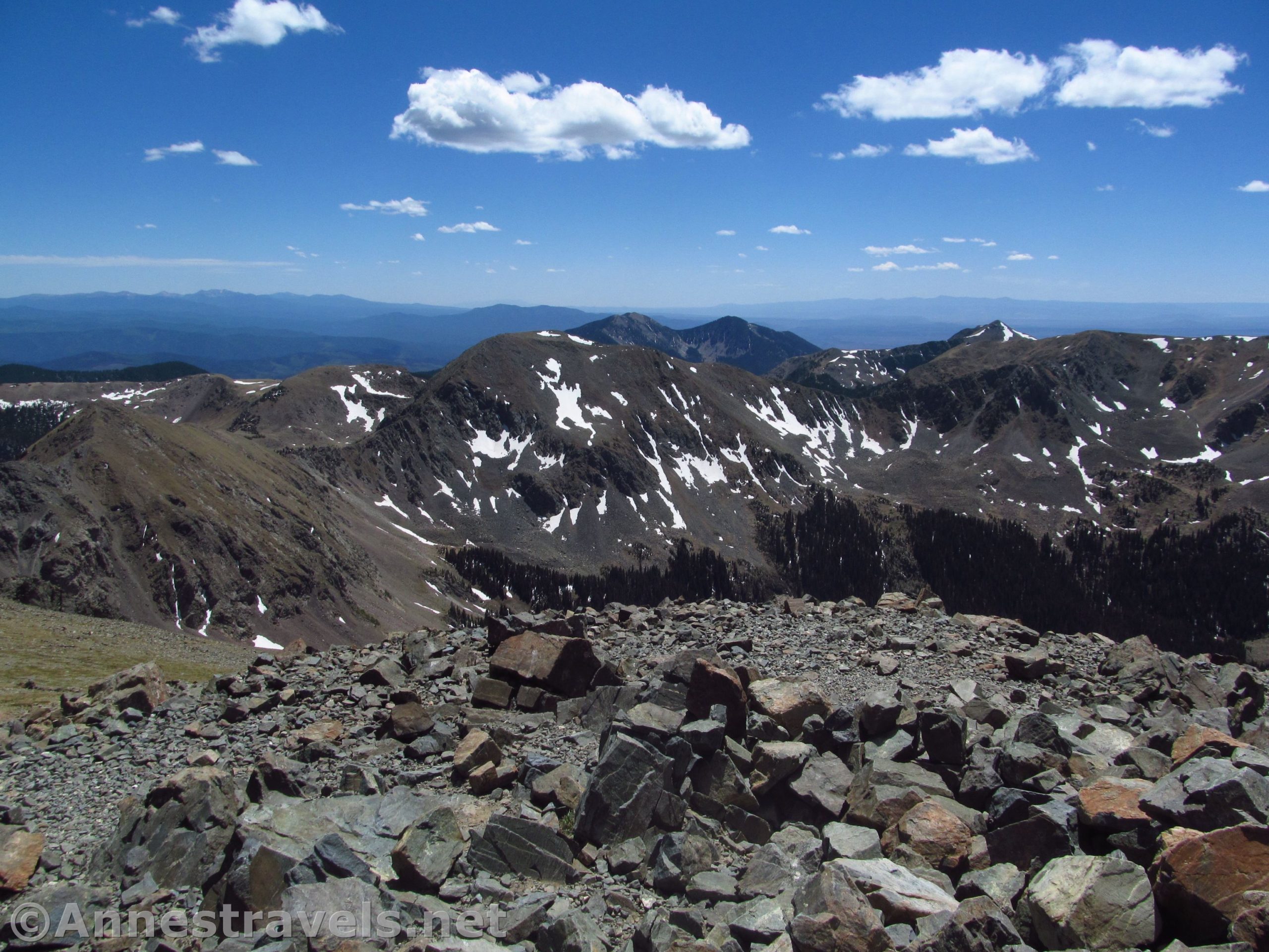
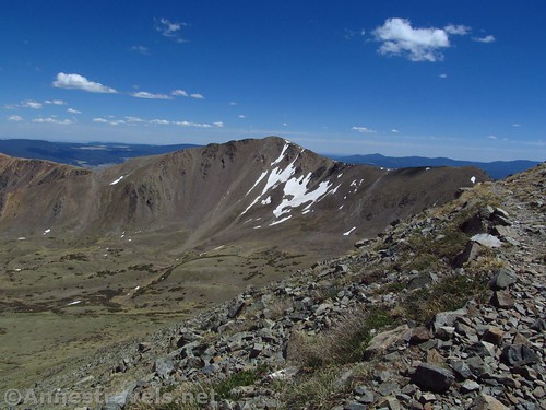
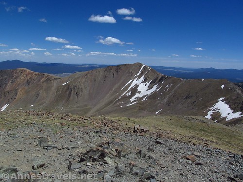
The views from Wheeler Peak are pretty glorious, especially early in the season, when the nearby cirque is still speckled with snow.
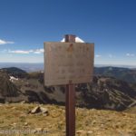
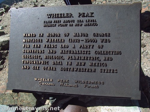
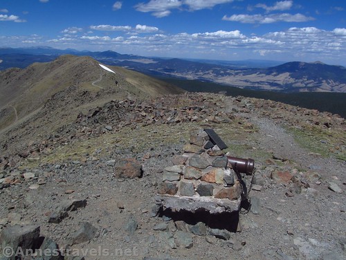
There is a trail register (looks a bit like a cannon) and a windbreak on the peak. It’s a well-used area, but also deserted when we were visiting (we met a number of people on the trail, but had the peak to ourselves – maybe we were a little late in the day, after visiting three other places on the trail first, lol).
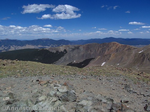
There are views in all directions – Red Dome and Taos Cone to the east, Old Mike Peak and Simpson Peak to the south, along with Pueblo Peak and Vallecito Mountain, Lake Fork Peak to the west, the Taos Ski Valley further north, Fraser Mountain and Mt. Walter close by to the north, with peaks ranging as far as the 14ers of Colorado beyond. It’s an incredible view on a clear day.

Enjoy the view (and the lack of oxygen – bring layers up here because the wind can be frigid even in the summer!) and then retrace your steps back down to the trailhead. It’s not an easy hike – 13ers rarely are easy – but it’s worth it for the view and the bragging rights of saying you’ve hit a state high point!
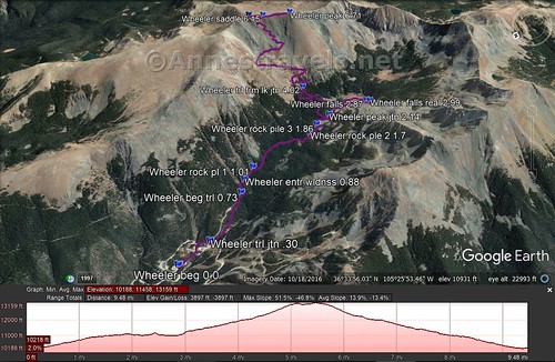
Round Trip Trail Length: Just Wheeler Peak: 9.2 miles; add Mt. Walter: 9.4 miles; add Williams Lake: 9.7 miles; add Williams Lake & Williams Falls: 10.9; Williams Lake, Williams Falls, Mt. Walter, and Wheeler Peak: 11.1 miles (though I ended 11.3 miles)
Elevation Change: 2,850ft. (10,299ft. at the trailhead to 13,149ft. on Wheeler Peak)
Facilities: A couple picnic tables and possibly port-a-potties at the trailhead
Fees: None
Trail Notes: Bring layers – it’s warm in the valley, but not on the peak, where the wind seems to be trying to tear through whatever clothes you’re wearing. Be wary of afternoon thundershowers in the summer – there really is no place to take shelter if a storm comes up. This is a 13er – the air is a lot thinner up here than in Taos! I highly recommend acclimating in the highlands of Colorado before hiking up Wheeler Peak.
Trail 
![]()
![]()
Road ![]()
![]()
Signs ![]()
![]()
Scenery
Would I go 100 miles out of my way for this?
Overall Rating: ![]()
GPS Coordinates for Wheeler Peak
Trailhead: 36.5791833°, -105.4400500° (N36° 34.751′ W105° 26.403′ / 36°34’45.0600″, -105°26’24.1800″) (10,299ft.) (0.0) (end 11.3)
Trail / Road Junction: 36.5759167°, -105.4390833° (N36° 34.555′ W105° 26.345′ / 36°34’33.3000″, -105°26’20.7000″) (10,299ft.) (0.30)
Begin Trail: 36.5713500°, -105.4355333° (N36° 34.281′ W105° 26.132′ / 36°34’16.8600″, -105°26’07.9200″) (10,506ft.) (0.73)
Enter Wheeler Peak Wilderness: 36.5704167°, -105.4341333° (N36° 34.225′ W105° 26.048′ / 36°34’13.5000″, -105°26’02.8800″) (10,581ft.) (0.88)
Rock Pile #1: 36.5690667°, -105.4331833° (N36° 34.144′ W105° 25.991′ / 36°34’08.6400″, -105°25’59.4600″) (10,646ft.) (1.01)
Rock Pile #2: 36.5623833°, -105.4327667° (N36° 33.743′ W105° 25.966′ / 36°33’44.5800″, -105°25’57.9600″) (10,999ft.) (1.7)
Rock Pile #3: 36.5611000°, -105.4319500° (N36° 33.666′ W105° 25.917′ / 36°33’39.9600″, -105°25’55.0200″) (11,019ft.) (1.86)
Wheeler Peak Junction: 36.5593167°, -105.4314500° (N36° 33.559′ W105° 25.887′ / 36°33’33.5400″, -105°25’53.2200″) (11,120ft.) (2.14; return 9.42)
Frm Lake Junction: 36.5597000°, -105.4260000° (N36° 33.582′ W105° 25.560′ / 36°33’34.9200″, -105°25’33.6000″) (11,421ft.) (4.02)
Wheeler Peak Saddle: 36.5595167°, -105.4151667° (N36° 33.571′ W105° 24.910′ / 36°33’34.2600″, -105°24’54.6000″) (13,025ft.) (6.15; return 6.43)
Mt. Walter: 36.5610500°, -105.4145000° (N36° 33.663′ W105° 24.870′ / 36°33’39.7800″, -105°24’52.2000″) (13,087ft.) (6.29)
Wheeler Peak: 36.5568833°, -105.4169500° (N36° 33.413′ W105° 25.017′ / 36°33’24.7800″, -105°25’01.0200″) (13,149ft.) (6.71)
The gpx file for Wheeler Peak (along with Williams Lake, Williams Falls, and Mt. Walter) can be downloaded – please note that this and the GPS Coordinates are for reference only and should not be used as a sole resource when hiking this trail.
Download GPX File size: 271.4 KB Downloaded 611 times
(Note: I do my best to ensure that all downloads, the webpage, etc. are virus-free and accurate; however, I cannot be held responsible for any damage that might result, including but not limited to loss of data, damages to hardware, harm to users, from use of files, information, etc. from this website. Thanks!)

Getting to the Wheeler Peak Parking Area
From Taos, New Mexico, drive north on US-64W. Outside of town, turn right on NM-150N, turning away from the The Rio Grande Gorge Bridge (which is a worthy destination unto itself.) (If you’re coming in from the north, take this turn where NM-522S meets US-64 – turn left toward the Taos Ski Valley).
Follow the NM-150N for almost 15 miles (a GPS is useful, but not required). You’ll pass through typical northern New Mexico plains, then enter an alpine canyon more fit for Colorado – it’s a beautiful (if steep) drive. Just before the main part of the ski valley, turn left up a wide, gravelish road / hill / parking area. Keep following the road upward, passing the Bull of the Woods Trailhead (it will probably say something about “Wheeler Peak Trail”, and while it will take you to Wheeler Peak eventually, you’re better off starting from the Williams Lake Trailhead). You’re now in a crazy network of roads – I highly recommend a GPS and common sense (because one can fill in where the other is lacking). In general, just keep driving upward on the very, very steep main road. About 2.2 miles above the beginning of the Ski Valley, a parking area will be on the right for Williams Lake. Park here. The roads may be closed until early summer due to snow.
Hike up to Williams Lake, following the roads and then trails up to the lake.
Zoom map out to browse nearby hikes & places of interest
This Week’s Featured Product!
Taos and Santa Fe are nearly surrounded by national forests. As such, they also offer some great hiking opportunities. This book will introduce you to more than 50 of these trails.