
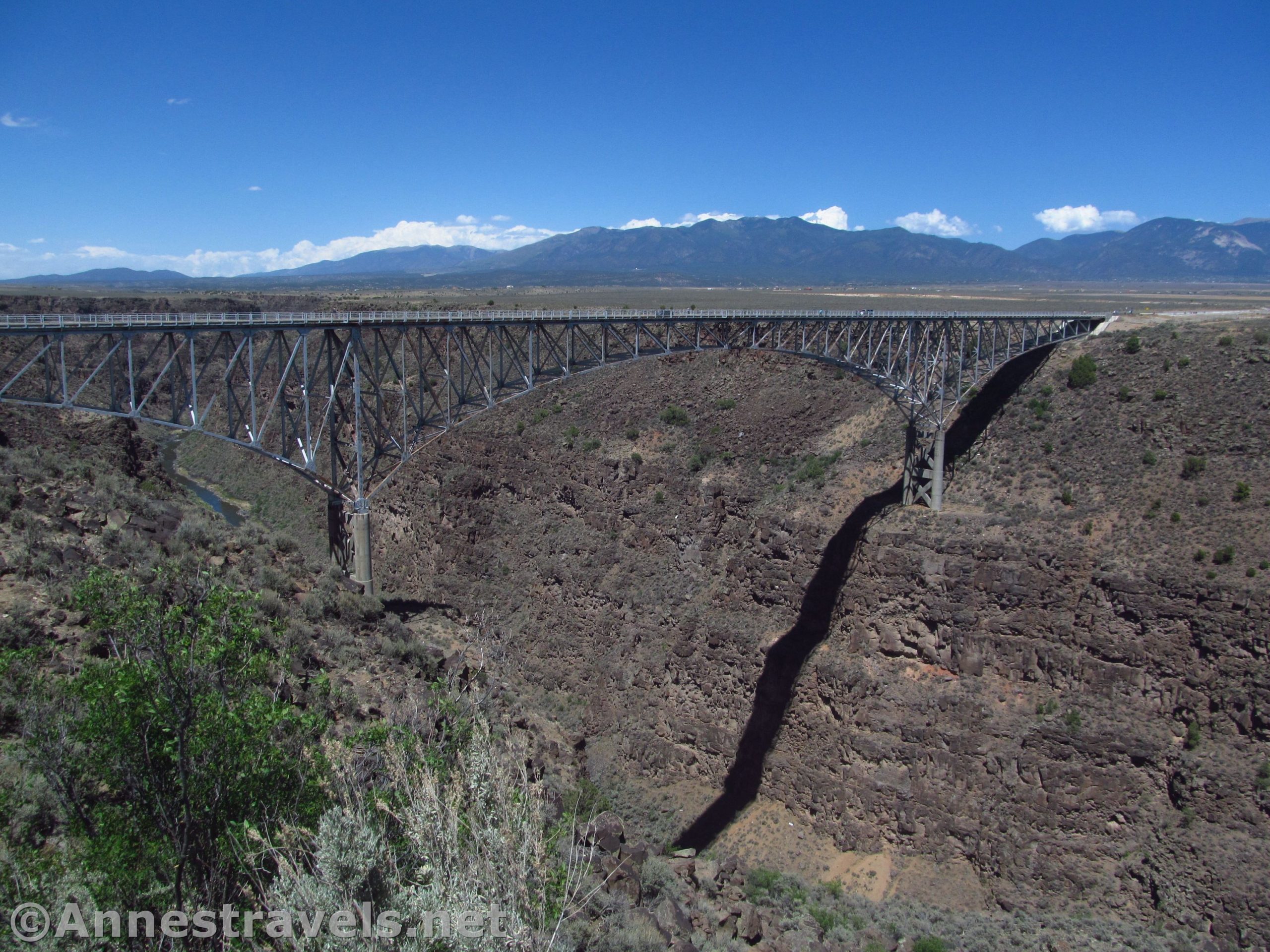

Just north and west of Taos, New Mexico, the Rio Grande Gorge cuts through the plateau for about 50 miles to depths of 800 feet. That in itself is interesting (and beautiful), but a road bridge was built over the (almost) deepest section of the canyon. Pedestrian walkways were constructed into the Rio Grande Gorge Bridge, so it’s perfectly possible to walk across the bridge and enjoy views of the canyon – it’s said that the bridge is the 10th highest in the United States, so the walkway is not for those afraid of heights!
Quick Stats

You can park on either side of the Rio Grande Gorge Bridge along US-64. We ended up parking on the east (Taos) side in a small pulloff because that’s where we were coming from and we were driving out of our way to see the bridge. However, you can also park in the Rio Grande Gorge Rest Area on the west side of the bridge. Both are free, though the rest area has restrooms and picnic tables as well as hiking trails.

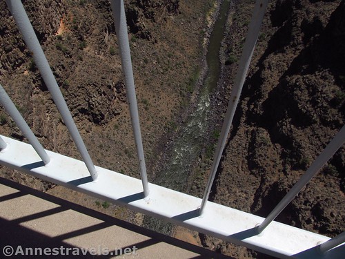
The views from the bridge are pretty impressive. There isn’t much more than a railing between you and the drop into the gorge, so this isn’t for the faint of heart or those who don’t like heights. We’ve hiked the Golden Gate Bridge and the Deception Pass Bridge, and this wasn’t too much worse than either of them. (I actually felt safer than on the Deception Pass Bridge because the road portion of the bridge is wider so we weren’t quite so close to the moving traffic.) Views are also good to the east toward Wheeler Peak (the New Mexico High Point) and the peaks around the Taos Ski Valley. Looking north, you can see the mountains of Colorado.

The bridge has a number of awards and distinctions. Besides being the 10th highest bridge in the United States (the Glen Canyon Dam Bridge, for one, is higher), and standing 565 feet (600ft. by some calculations) over the Rio Grande River, the American Institute of Steel Construction presented a plaque calling it the “Most Beautiful Bridge” in the Long Span category in 1966. The bridge is on both the New Mexico State Register of Cultural Properties and the United States Register of Historic Places.

The canyon has a fair number of whitewater rapids, so you might spot some rafters on the river. Hot springs abound on the banks, and ancient ruins have been found near the springs. A famous narrow gauge railroad better known as the “Chili Line” or officially known as the Santa Fe Branch, once ran along the bottom of the canyon, but it was removed in 1942. The area was also used as a training ground for the Apollo astronauts since the geography closely resembled the proposed moon-landing site.

We walked across the bridge east-to-west and then climbed over the guardrail to access the Rio Grande Gorge Rest Area. (You might as well use a restroom while there’s one available!) We also walked down to the canyon rim to a viewpoint where you can take photos of the bridge, itself, and see if it’s as beautiful as the American Institute of Steel Construction thought it was.

Several trails in the Rio Grande del Norte National Monument start or can be accessed from the rest area, so it would be easy enough to continue hiking along the canyon rim. It was a hot day, we’d already hiked to the top of Star Dune in Great Sand Dunes National Park, and we wanted to get ourselves well-situated for hiking Wheeler Peak the next day. All that to say, we weren’t really looking for an extra hike, so we turned around and walked back across the bridge to our van.

You won’t spend more than an hour looking at the bridge – probably not more than half an hour – but the views are good, so the Rio Grande Gorge Bridge is worth a short detour if you happen to be in the area.

Round Trip Length: About 0.8 miles to cross the bridge and come back. Going up to the rest area and down to the viewpoint put me at about 1.25 miles.
Elevation Gain: About 75ft. (7,031ft. to 6,960ft.)
Facilities: Restrooms and picnic tables in the rest area
Fees: None
Trail Notes: This is a very high bridge with only a railing between you and space. It’s not for people who don’t like heights. Also note that I was not overly excited about the “feel” around the bridge – too many people have committed suicide here. Do not park on the bridge, itself; there are pulloffs at either end for parking. It is unlawful to throw objects (including rocks) from the bridge into the canyon.
Trail 
Road
Signs
Scenery ![]()
Would I go 100 miles out of my way for this? ![]()
![]()
![]()
Overall Rating: ![]()

GPS Coordinates for the Rio Grande Gorge Bridge
Parking: 36.4761333°, -105.7283167° (N36° 28.568′ W105° 43.699′ / 36°28’34.0800″, -105°43’41.9400″) (7,031ft.) (0.0) (end )
Turn to Rest Area: 36.4762000°, -105.7359500° (N36° 28.572′ W105° 44.157′ / 36°28’34.3200″, -105°44’09.4200″) (6,960ft.) (says 4.4; likely 0.44)
Viewpoint: 36.4747500°, -105.7350333° (N36° 28.485′ W105° 44.102′ / 36°28’29.1000″, -105°44’06.1200″) (6,973ft.) (0.59)
The gpx file for walking across the Rio Grande Gorge Bridge can be downloaded – please note that this and the GPS Coordinates are for reference only and should not be used as a sole resource when hiking this trail.
Download GPX File size: 23.6 KB Downloaded 539 times
(Note: I do my best to ensure that all downloads, the webpage, etc. are virus-free and accurate; however, I cannot be held responsible for any damage that might result, including but not limited to loss of data, damages to hardware, harm to users, from use of files, information, etc. from this website. Thanks!)

Getting to the Rio Grande Gorge Bridge
From Taos, drive north on US-64W. After about 4 miles, turn left to stay on US-64W (this turn is not quite 40 miles south of the Colorado border). A green road sign will fairly quickly tell you that the Rio Grande Gorge Bridge is in 7 miles. Per Google, the bridge is 7.5 miles from the intersection.
The bridge is also 19.5 miles east of the US-285/US-64 intersection in Tres Piedras.

This Week’s Featured Product!
Hike the area around Taos with confidence using this guide. Trails rise high into the Sangre de Cristo Mountains and down to the shores of the Rio Grande River

3 responses to “Walk Across the Rio Grande Gorge Bridge!”
Did you do this in June 2020 and was the West Rim trail open? We we’re planning on going but don’t want to make such a long trip for it to be closed!
I hiked this in June of 2018 (it’s taken me a while to blog about it!) From what I can tell online, the park is open (at the very least, people are hiking there and not reporting closures). I’d call the Taos Field Office (575-758-8851) to be sure.
Thank you so much for your help!