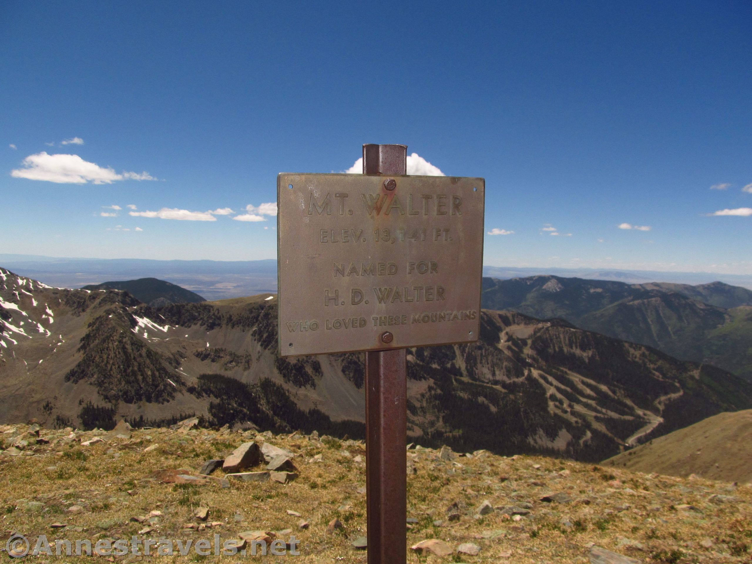

Mount Walter might well be seen as the handsome little brother of Wheeler Peak, the highest Point in New Mexico. Located only 0.4 miles north of – and 62 feet lower than – Wheeler Peak, Mount Walter is overlooked by most people climbing up to bag the higher peak. But the views from Mt. Walter make it well worth the extra 0.25 miles RT to make it to the second highest point in New Mexico – not the second highest peak, since there isn’t enough of a dip in the ridgeline for the sticklers to say Mount Walter has enough prominence to be its own mountain peak.
Quick Stats
(Affiliate links are present on this page.)
Hike the Williams Lake Trail 2.1 miles to the Wheeler Peak Trail Junction and turn left up the Wheeler Peak Trail. You can also hike to Williams Lake first (and visit Williams Falls!) if you want to (adds 0.5 to 1.7 miles to the overall hike).
If you begin from Williams Lake: The easiest thing to do is just to hike back up the Williams Lake Trail to the Wheeler Peak Junction. However, we had seen (on maps) that a trail began from the northwest side of the Williams Lake clearing, striking upward through the forest to connect to the Wheeler Peak Trail. It was supposed to be a shortcut. So we went up to the northwest side of the clearing, but found no sign of a trail. Knowing generally where it was supposed to be, we just started climbing through the trees. There were remnants of a trail, and even occasionally ribbon on some of the trees, but I think we finally just climbed a dry watercourse that eventually crossed the Wheeler Peak Trail. We turned right and upward and continued our journey.
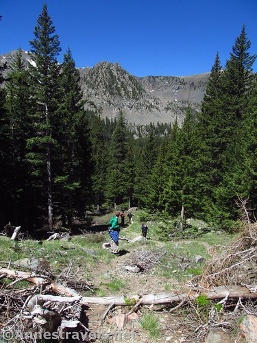
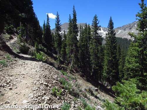
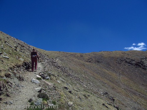
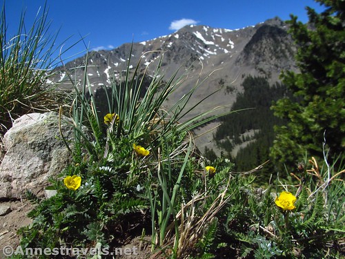
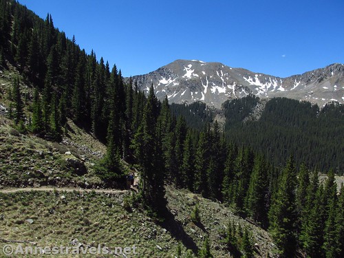
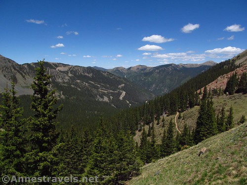
The Wheeler Peak Trail is quite easy to follow 90% of the time, but it is also very steep 90% of the time. Well, maybe only 70%; it just feels like it’s steep all the time because it’s such high elevation (and coming from living at 300ft. only a few days before, we weren’t exactly acclimated!) The trail climbs through the trees for a bit, then breaks out in the ragged treeline to fantastic views into the valley below and of the surrounding peaks.
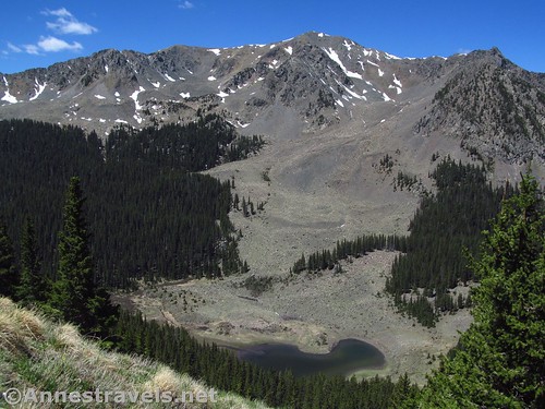
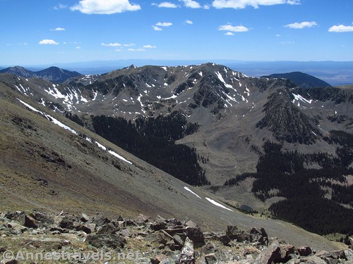
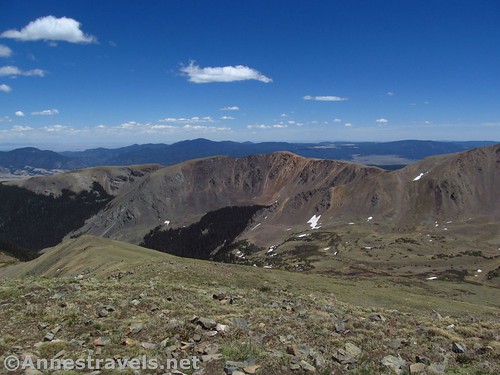
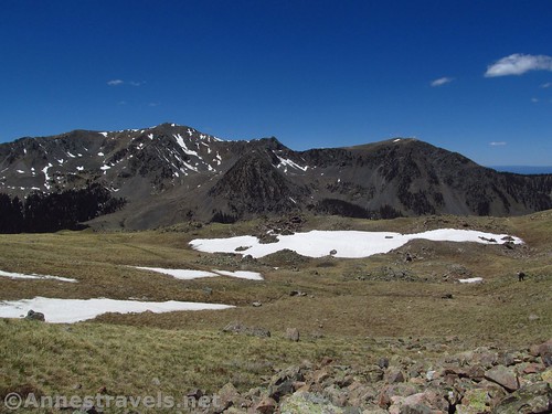
The views were even better because it was early in the season, so some of the peaks still were streaked with snow. Actually, when we visited, which was in late May, the trail should have still been snow-covered. However, there had been a very light snow year the winter before (25% snowpack; not-so-far-away Great Sand Dunes had seen the stream across the dune field dry up in April or early May) so we were able to hike despite the time of year.
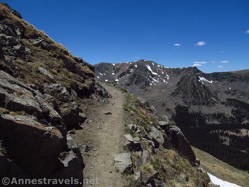
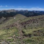
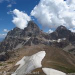
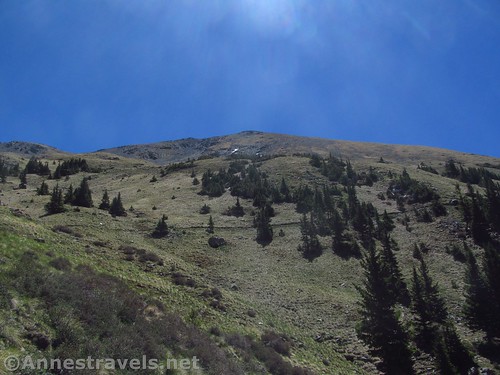
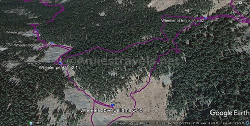
The trail seems to hang off the side of the mountain in places; this is definitely not the favorite trail for those with vertigo. It finally switchbacks up into a grassy bowl, crosses the bowl, and switchbacks up through meadows and scree fields (watch for the trail; it’s not hard to follow but occasionally a scree-filled drainage is as good or better route as the trail) to the saddle (just over 13,000ft.) between Mount Walter (left) and Wheeler Peak (right), about 4.3 miles from the trailhead.
Once in the saddle, turn left up the light, but well-defined, trail toward the sign on the peak. It’s only 0.1 miles up the (nowhere near as steep) ridgeline to the top of Mt. Walter.
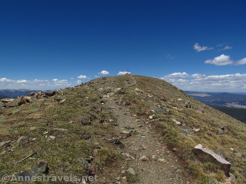
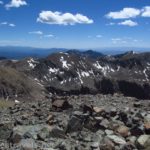
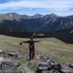
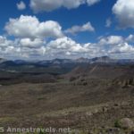
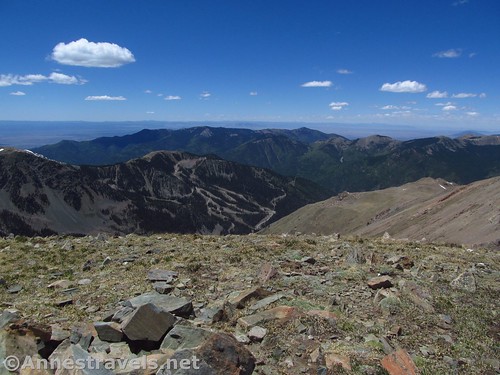
If you think the views are good in the saddle, they get exponentially better on Mt. Walter. I’m not sure why; it’s mostly the same view. But it’s better somehow, more all-compassing of Red Dome and Taos Cone across the valley, Touch-Me-Not Mountain, Baldy Mountain, Blanca Peak (in Colorado), Gold Hill, Flag Mountain, and many others.
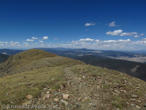
After enjoying the view on the mostly-deserted peak (did I mention that few people actually come up here?), you can either continue along the ridgeline (on the Blue Lake Trail) or head back down to the saddle to ascend Wheeler Peak (why not, you’re here, right?) or descend back to the parking area.
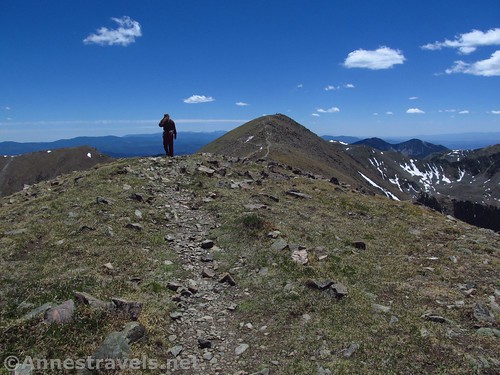
Overall? Mount Walter is a beautiful hike on its own, even better if you want to bag it as a 0.25 miles RT side-jaunt from hiking Wheeler Peak. To be honest, I zipped up there, got my pictures, and was resting in the saddle by the time the rest of the group came up the last switchback. Then we could all go up Wheeler Peak together!
Round Trip Trail Length: 8.8 miles up Mount Walter and back; 9.3 miles with Williams Lake; 10.5 with Williams Lake and Williams Falls. Add 0.6 miles RT to bag Wheeler Peak as well.
Net Elevation Change: 2,788ft. (10,299ft. at the trailhead to 13,087ft. on Mt. Walter)
Facilities: A couple picnic tables at the trailhead; port-a-potties when I visited. More services available in the Taos Ski Valley; nearest gas is probably in Taos.
Fees: None
Trail Notes: The worst thing about this trail is the elevation – you’re basically hiking from 10,000ft. (much higher than the surrounding plains near Taos) to 13,000ft. – lung bustingly high for the continental US. I highly recommend acclimating in the highlands of Colorado before hiking. Be wary of afternoon thundershowers in the summer. There isn’t much in the way of shelter along this trail.
Trail 
![]()
![]()
Road ![]()
![]()
Signs ![]()
![]()
Scenery
Would I go 100 miles out of my way for this?
Overall Rating: ![]()
GPS Coordinates for Wheeler Peak
Trailhead: 36.5791833°, -105.4400500° (N36° 34.751′ W105° 26.403′ / 36°34’45.0600″, -105°26’24.1800″) (10,299ft.) (0.0) (end 11.3)
Trail / Road Junction: 36.5759167°, -105.4390833° (N36° 34.555′ W105° 26.345′ / 36°34’33.3000″, -105°26’20.7000″) (10,299ft.) (0.30)
Begin Trail: 36.5713500°, -105.4355333° (N36° 34.281′ W105° 26.132′ / 36°34’16.8600″, -105°26’07.9200″) (10,506ft.) (0.73)
Enter Wheeler Peak Wilderness: 36.5704167°, -105.4341333° (N36° 34.225′ W105° 26.048′ / 36°34’13.5000″, -105°26’02.8800″) (10,581ft.) (0.88)
Rock Pile #1: 36.5690667°, -105.4331833° (N36° 34.144′ W105° 25.991′ / 36°34’08.6400″, -105°25’59.4600″) (10,646ft.) (1.01)
Rock Pile #2: 36.5623833°, -105.4327667° (N36° 33.743′ W105° 25.966′ / 36°33’44.5800″, -105°25’57.9600″) (10,999ft.) (1.7)
Rock Pile #3: 36.5611000°, -105.4319500° (N36° 33.666′ W105° 25.917′ / 36°33’39.9600″, -105°25’55.0200″) (11,019ft.) (1.86)
Wheeler Peak Junction: 36.5593167°, -105.4314500° (N36° 33.559′ W105° 25.887′ / 36°33’33.5400″, -105°25’53.2200″) (11,120ft.) (2.14; return 9.42)
Frm Lake Junction (I don’t know what frm is – likely where I met up with the Wheeler Peak Trail above Williams Lake): 36.5597000°, -105.4260000° (N36° 33.582′ W105° 25.560′ / 36°33’34.9200″, -105°25’33.6000″) (11,421ft.) (4.02)
Wheeler Peak Saddle: 36.5595167°, -105.4151667° (N36° 33.571′ W105° 24.910′ / 36°33’34.2600″, -105°24’54.6000″) (13,025ft.) (6.15; return 6.43)
Mt. Walter: 36.5610500°, -105.4145000° (N36° 33.663′ W105° 24.870′ / 36°33’39.7800″, -105°24’52.2000″) (13,087ft.) (6.29)
The gpx file for Mount Walter (along with Williams Lake, Williams Falls, and Wheeler Peak) can be downloaded – please note that this and the GPS Coordinates are for reference only and should not be used as a sole resource when hiking this trail.
Download GPX File size: 271.4 KB Downloaded 509 times
(Note: I do my best to ensure that all downloads, the webpage, etc. are virus-free and accurate; however, I cannot be held responsible for any damage that might result, including but not limited to loss of data, damages to hardware, harm to users, from use of files, information, etc. from this website. Thanks!)
Getting to the Wheeler Peak Parking Area
From Taos, New Mexico, drive north on US-64W. Outside of town, turn right on NM-150N, turning away from the The Rio Grande Gorge Bridge (which is a worthy destination unto itself.) (If you’re coming in from the north, take this turn where NM-522S meets US-64 – turn left toward the Taos Ski Valley).
Follow the NM-150N for almost 15 miles (a GPS is useful, but not required). You’ll pass through typical northern New Mexico plains, then enter an alpine canyon more fit for Colorado – it’s a beautiful (if steep) drive. Just before the main part of the ski valley, turn left up a wide, gravelish road / hill / parking area. Keep following the road upward, passing the Bull of the Woods Trailhead (it will probably say something about “Wheeler Peak Trail”, and while it will take you to Wheeler Peak eventually, you’re better off starting from the Williams Lake Trailhead). You’re now in a crazy network of roads – I highly recommend a GPS and common sense (because one can fill in where the other is lacking). In general, just keep driving upward on the very, very steep main road. About 2.2 miles above the beginning of the Ski Valley, a parking area will be on the right for Williams Lake. Park here. The roads may be closed until early summer due to snow.
Hike up the Williams Lake Trail, following the roads and then trails up to the Wheeler Peak Trail Junction.

Zoom map out to browse nearby hikes & places of interest
This Week’s Featured Product!
If off-the-beaten-trail is your goal, check out this book by a 62-year-resident of Taos, covering most of the mountains in the area… trails are optional.