
I’ve loved the rock formations in the Bisti area ever since my first visit in 2003. Somehow the ability to explore without trails, to discover rock formations – the first person ever, maybe – with no signs telling you what you can and can’t touch, the wildness of it all was an intrigue that brought me back several more times in the following years. But in looking for additional information on the area, I also ran across another somewhat-nearby wilderness, containing the famous Valley of Dreams.
Quick Stats
(Affiliate links are present on this page.)
Finding information on the Valley of Dreams is exciting at best and non-existent at worst. You can find pictures, no problem there. But the internet community has generally silently pledged to not tell exactly where these incredible rock formations reside, how exactly to get there, or directions on finding the formations once you get there.
It adds to the adventure, not doubt about it. It also could potentially create hazardous conditions for those who try to find it. But in general, those who go searching are well enough prepared that “hazardous” would not be the first thing to come to mind.
And so I’ll follow in their footsteps and only give general directions. But I will give half-descent walking directions to the Valley of Dreams East (and in the next post, the Valley of Dreams) from the parking areas.
Note that the area where you park is on private land or possibly right on the edge of BLM land. It’s ok to park there, but use even greater respect than you would on public land. It’s what keeps these areas open to the public, like you and me.
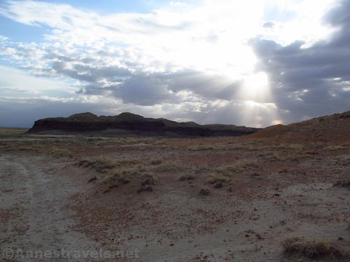
Also note that the Valley of Dreams East is in the middle of absolute nowhere. And I mean that. You’re miles and miles from any kind of civilization. Come prepared!
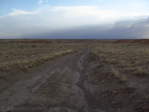
The roads are all dirt. In general, most of the roads could have been traversed in a low-clearance vehicle. We did just fine in our high-clearance E-150, though there were two sandy sections between the two parking areas that scared us half silly (I missed the first parking area, so I thought we were still fine until suddenly we were charging through the sand – thankfully the van handled it ok, though I give the credit to that in part to the driver who is used to driving Dodge vans in conditions usually not quite as bad as this.)
Car GPSes won’t get you there. The roads are extremely confusing, and GPSes make it worse. Honestly. Our Garman was constantly taking us on roads that didn’t exist, even straight through people’s houses, then missing the existence of perfect good roads. It was a nightmare we got through more through intuition and a variety of maps I had printed of the web than because of our road GPS. I did plug what coordinates I had into my hiking GPS, so we at least knew where we were trying to get to.
All roads are impassible in wet conditions. Please do not drive on them when wet! It’s more than you getting stuck or not getting stuck; it’s about keeping the roads open to public use, and if we leave ruts, or get stuck, it’s highly likely the roads will be closed (by hook or by crook, so to speak) by land owners.
There are no trails. That said, there is a road and a wash to follow. So while it’s not real likely that you will get lost, it’s altogether possible. Come prepared with lifesaving essentials, including a good compass and good map of the area (and know how to use them!). A hiking GPS, properly used, is also useful.
And now, for the hiking directions:
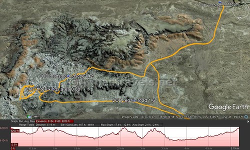
From the either parking area, continue walking north-ish on the road. It is vague, but still there. There will be some reddish hills on your right. After rounding a black badland hill, the road will cross a very wide wash. Turn right (east) here, on the near side of the wash, and the Valley of Dreams East is on right (south) side of the wash.
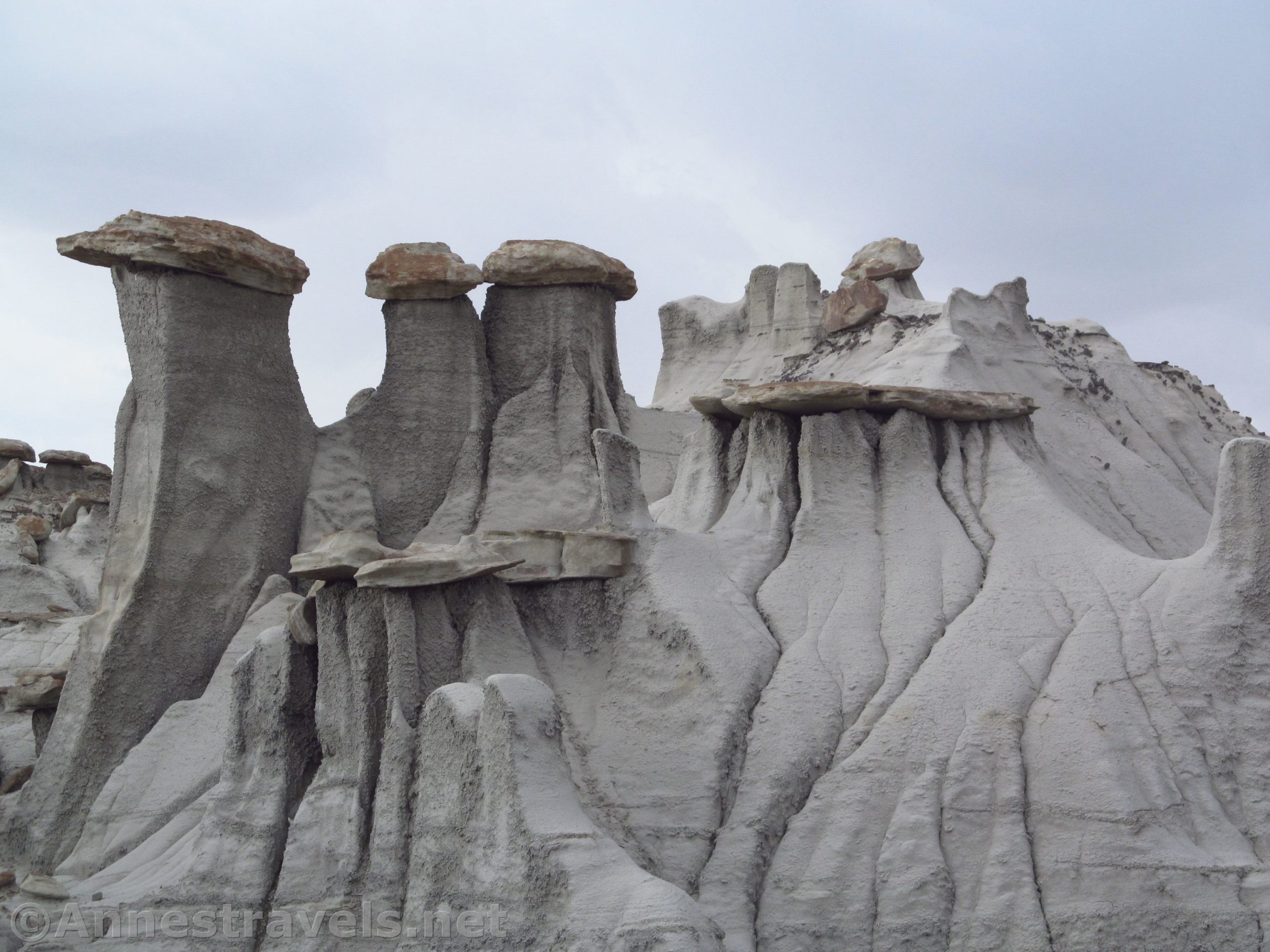
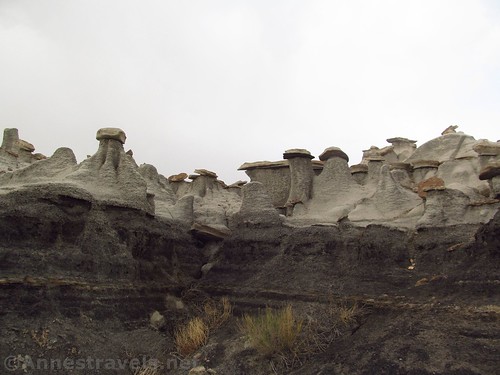
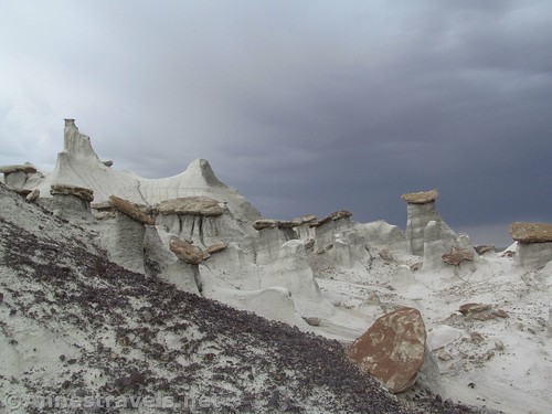
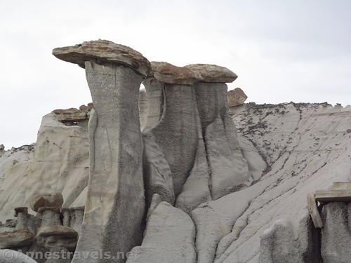
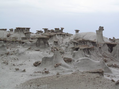
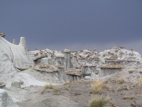
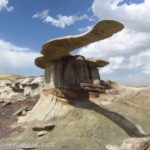
We didn’t explore as much as we could have, but we did walk through about three alcoves of formations, all incredible. The first alcove contains the “Three Wise Men” formation, though I never specifically found it.
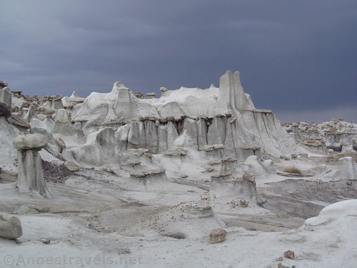
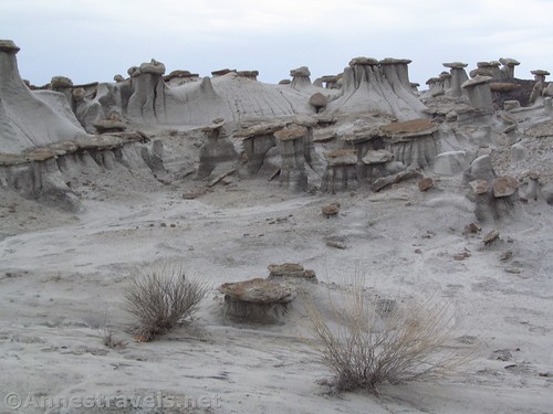
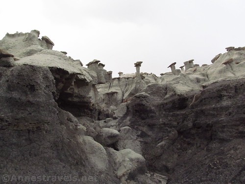
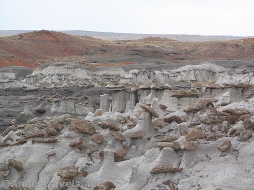
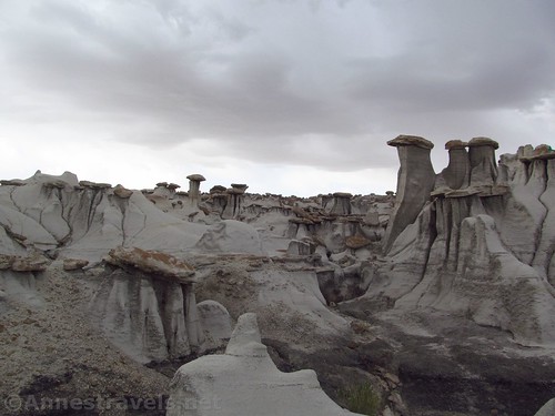
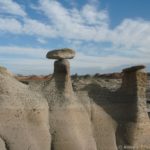
Actually, on our way in, we got confused on our maps and ended up walking up one wash too soon. The scenery was great, black badlands and grey badlands with thousands of toadstool formations up above the wash. When we figured out our error, we crossed through the toadstools (walk carefully!) and scrambled down the other side of the hill. Not optimal, but not too bad, either.
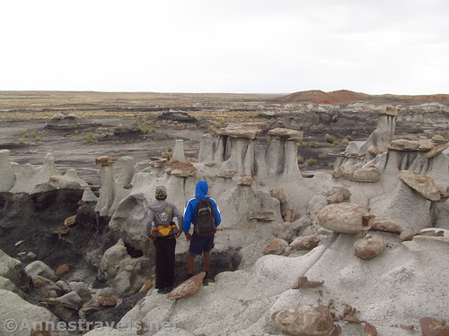
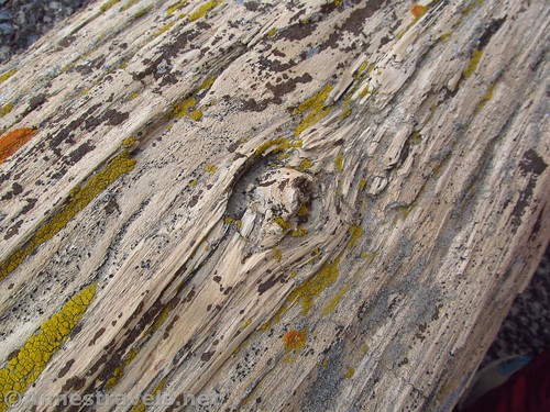
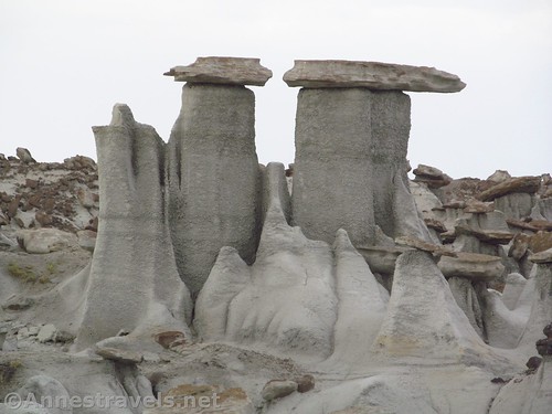
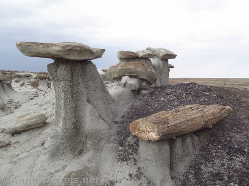
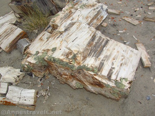
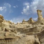
You can wander for a long way, and there seems to always be more formations. Also keep an eye out for petrified logs – there are several – along with dinosaur fossils.
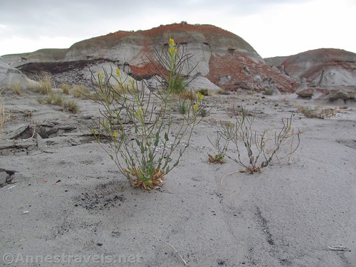
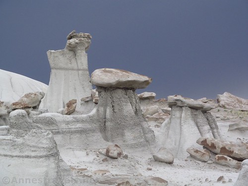
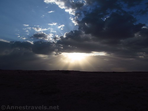
Unfortunately, the day wasn’t especially sunny. The good thing was that since this was June, it would have been incredibly hot if the sun had been out, so it was much more pleasant to have cloudy skies, even if the pictures weren’t quite as great as they might have been.
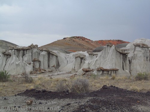
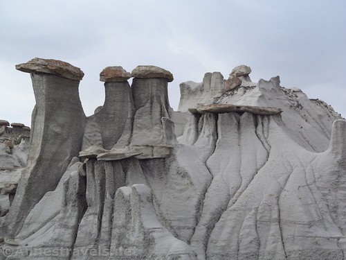
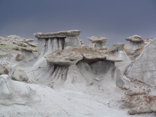
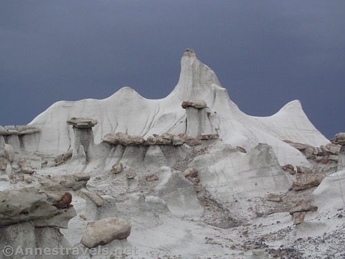
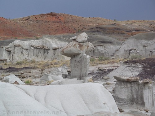
Most of the rock formations in the Valley of Dreams East are hoodoos and pillars of badland with rocks on top. There are a thousand variations on the theme (probably more), but that’s what most of the formations are like.
While we were at the far end of the Valley of Dreams East (at least, as far east as we went), a storm rolled it. We briefly considered abandoning the place so we could get out before the rain made the road impassible, but thankfully it only sprinkled and the storm moved on. Still, we kept half an ear out for flash floods.
We enjoyed the scenery for a bit, then walked back down the wash to the remains of the road. From here, we would explore the Valley of Dreams, but that’s a topic for another post!
Round Trip Trail Length: Just the Valley of Dreams East from where we parked would have been about 2.3 miles. It’s all relative depending on how you walk and where you go.
Elevation Change: Not a whole lot. It depends on how much you scramble around.
Facilities: None. Did you read about how it’s in the middle of “absolute nowhere”?
Fees: None
Trail Notes: I’ve already put most of the notes in the upper part of the post, but remember that you’re totally alone out here and don’t expect rescue or cell service if something goes wrong. Be used to wayfinding in the desert before you attempt this.
GPS Coordinates for the Valley of Dreams East
Road to the Valley of Dreams: 36.1240833°, -107.9801833° (N36° 07.445′ W107° 58.811′ / 36°07’26.7000″, -107°58’48.6600″) (6,257ft.)
Beginning (where we parked): 36.1407333°, -107.9666333° (N36° 08.444′ W107° 57.998′ / 36°08’26.6400″, -107°57’59.8800″) (6,169ft.) (0.0) (end 5.88)
Valley of Dreams East / Three Kings Area: 36.1466500°, -107.9581500° (N36° 08.799′ W107° 57.489′ / 36°08’47.9400″, -107°57’29.3400″) (6,158ft.) (0.88)
Getting to the Valley of Dreams East
From Bloomfield, NM, drive 28 miles south on US-550S. Turn right onto NM-57 for 21.1 miles. Turn right onto Rt 7022 (though Google marks it as 7870 – the road is marked) for 1.8 miles to turn right on an unmarked dirt road (intersection is approximately 36.1240833°, -107.9801833° (N36° 07.445′ W107° 58.811′ / 36°07’26.7000″, -107°58’48.6600″)). Follow the road 1.6 miles and park in the small dirt/desert area that could be a parking area just before the “road” crosses what looks like a small drainage and becomes noticeably worse. I saw that a jeep had driven down to the wash, itself, but I wouldn’t recommend that for a lot of reasons (including environmental).
From Farmington: Follow NM-371 S for 45 miles. Turn left onto County Road 7650 for 7.8 miles, then turn right on another well-maintained dirt road (I believe it is signed as CR-7870). Follow this road about 5 miles to an unmarked road on left at 36.1240833°, -107.9801833° (N36° 07.445′ W107° 58.811′ / 36°07’26.7000″, -107°58’48.6600″). Follow the road 1.6 miles and park in the small dirt/desert area that could be a parking area just before the “road” crosses what looks like a small drainage and becomes noticeably worse. I saw that a jeep had driven down to the wash, itself, but I wouldn’t recommend that for a lot of reasons (including environmental).
From the road to Chaco: This is possible, but not fun. It is impossible without high clearance; 4×4 highly recommended (this was how I came in, so I know what it’s like!) Follow the signs for Chaco from US-550. After 17 miles on the dirt road, you will cross a wash. Very shortly after rising out of the wash, a very primitive road will go off on the right (west) side of the road. Turn onto this road; be very careful to take the routes that follow the wash, but do not go into the wash or cross the wash (there are several primitive roads in this area leading in various directions). The road will eventually improve and you should be able to tell which way to go. Google calls the better road that you are on CR-7980. If you have any questions on which way to go, stay on the south side of the wash, but don’t stray too far from the wash, either. After about 6.5 miles, CR-7980 will T into NM-57. Turn right and almost immediately cross the wash. Only 0.7 miles later, turn left onto Rt-7022 (aka 7870 – the road is marked) for 1.8 miles to turn right on an unmarked dirt road (intersection is approximately 36.1240833°, -107.9801833° (N36° 07.445′ W107° 58.811′ / 36°07’26.7000″, -107°58’48.6600″)). Follow the road 1.6 miles and park in the small dirt/desert area that could be a parking area just before the “road” crosses what looks like a small drainage and becomes noticeably worse. I saw that a jeep had driven down to the wash, itself, but I wouldn’t recommend that for a lot of reasons (including environmental).
If you don’t have high clearance / 4×4: Find a small roughed up spot that could be a parking area about 1 mile from the final road junction. This will avoid the sandy spots.
If you come in via NM-57 from the north, or if you continue north on NM-57 if coming from the south, you’ll pass the parking area for the Ah-Shi-Sle-Pah Wilderness Study Area. It’s well-marked and might be another worthy place to hike! (Approx. 36.139912, -107.920714 (36 08.39472′, -107 55.24284′ / 36 08’23.6832″, -107 55’14.5704″))
Zoom map out to browse nearby hikes & places of interest
This Week’s Featured Product!
Looking for more off-the-beaten-path destinations to explore? Try this book with unique natural destinations across New Mexico.


2 responses to “Visiting the Valley of Dreams East”
[…] Last week, I posted about our trek to and through the Valley of Dreams East. As spectacular as it is, even more interesting (to me, at least!) was the Valley of Dreams. It’s only about 1.25 miles down the wash from the Valley of Dreams East. The formations are in some ways more concentrated, and there’s a lot more variety in the formations to gawk at. Overall, it’s just a cooler place to be. The entire area is a maze of toadstools, crazily eroded formations, little windows, petrified wood, and more, so it can take some time to explore (I’m sure I didn’t do the exploration justice!) […]
[…] A little more recently – probably only about three or four years ago – I heard of an area of rock formations called the Valley of Dreams. It’s extremely remote, and very difficult to get to, but it’s amazing! First we visited the Valley of Dreams East… […]